2022 Vol. 41, No. 7
Display Method:
2022, 41(7): 1-12.
doi: 10.1007/s13131-022-2013-5
Abstract:
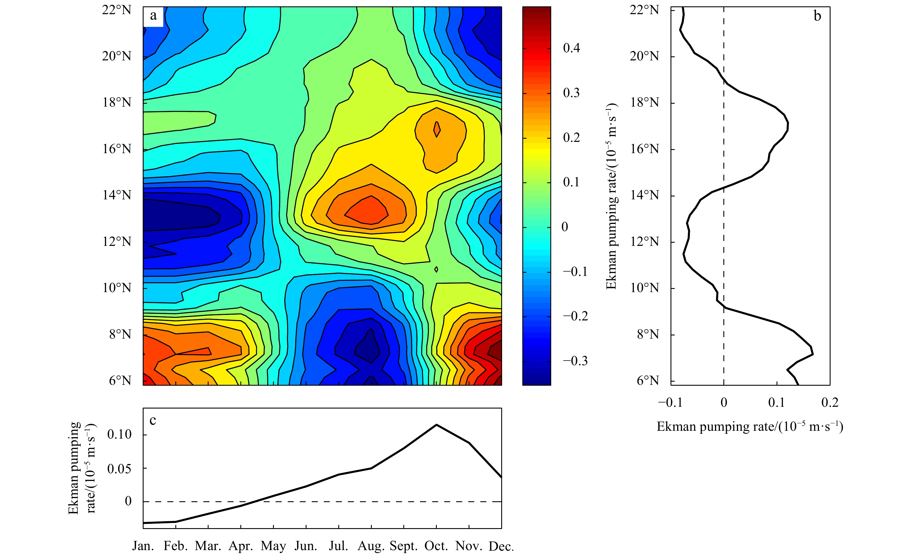
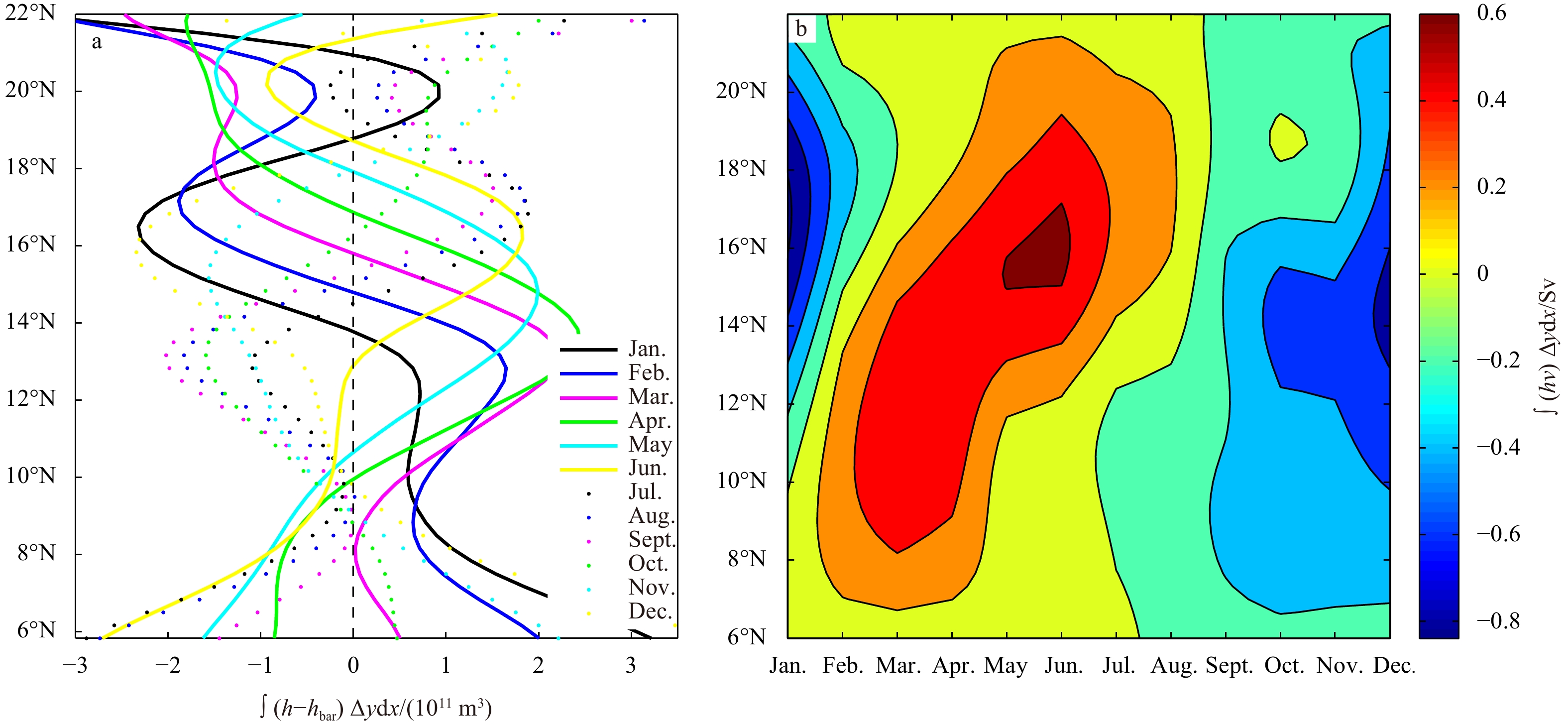
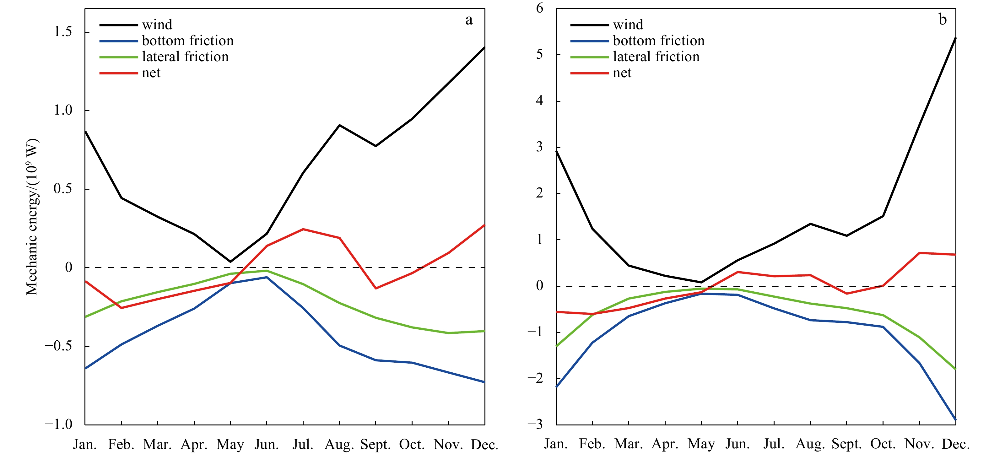
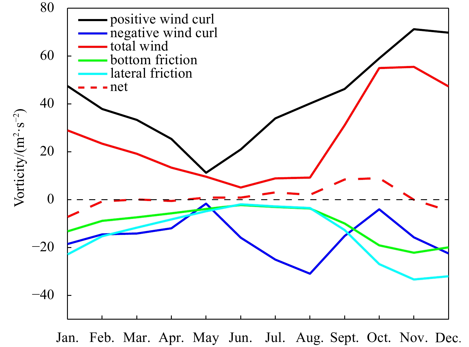
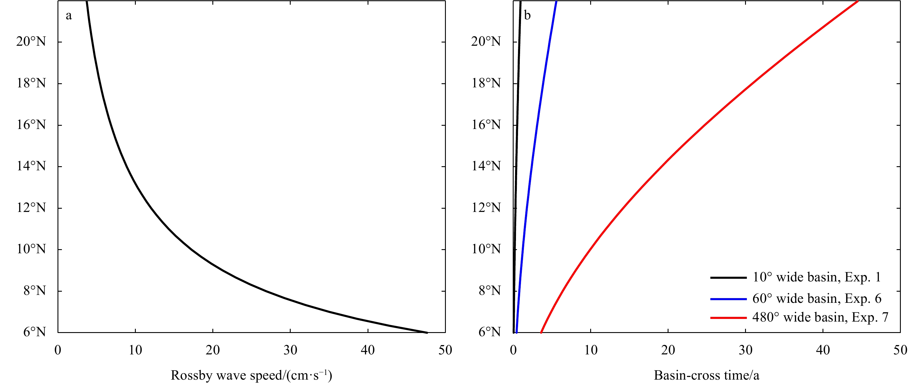
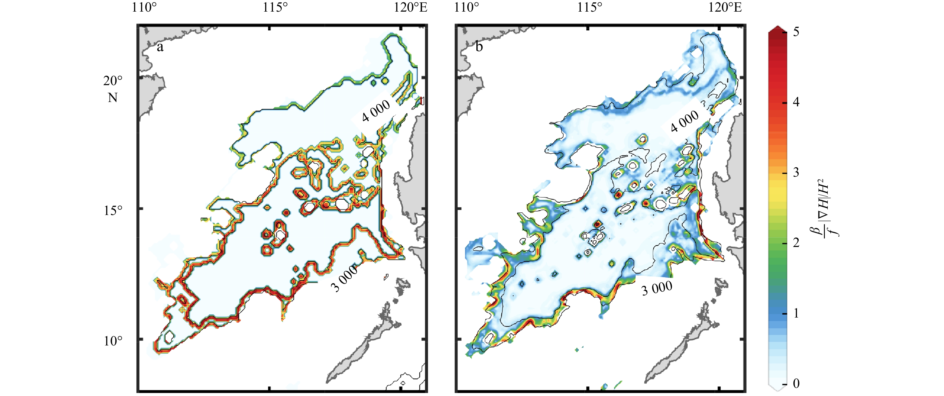
The South China Sea (SCS) is a narrow semi-enclosed basin, ranging from 4°–6°N to 21°–22°N meridionally. It is forced by a strong annual cycle of monsoon-related wind stress. The Coriolis parameter f increases at least three times from the southern basin to the northern basin. As a result, the basin-cross time for the first baroclinic Rossby wave in the southern part of the basin is about 10-times faster than that in the northern part, which plays the most vitally important role in setting the circulation. At the northernmost edge of SCS, the first baroclinic Rossby wave takes slightly less than 1 year to move across the basin, however, it takes only 1–2 months in the southernmost part. Therefore, circulation properties for a station in the model ocean are not solely determined by the forcing at that time instance only; instead, they depend on the information over the past months. The combination of a strong annual cycle of wind forcing and large difference of basin-cross time for the first baroclinic Rossby wave leads to a strong seasonal cycle of the circulation in the SCS, hence, the circulation is dominated by the forced oscillations, rather than the quasi-steady state discussed in many textbooks.The circulation in the SCS is explored in detail by using a simple reduced gravity model forced by seasonally varying zonal wind stress. In particular, for a given time snap the western boundary current in the SCS cannot play the role of balancing mass transport across each latitude nor balancing mechanical energy and vorticity in the whole basin. In a departure from the steady wind-driven circulation discussed in many existing textbooks, the circulation in the SCS is characterized by the imbalance of mechanical energy and vorticity for the whole basin at any part of the seasonal cycle. In particular, the western boundary current in the SCS cannot balance the mass, mechanical energy, and vorticity in the seasonal cycle of the basin. Consequently, the circulation near the western boundary cannot be interpreted in terms of the wind stress and thermohaline forcing at the same time. Instead, circulation properties near the western boundary should be interpreted in terms of the contributions due to the delayed wind stress and the eastern boundary layer thickness. In fact, there is a clear annual cycle of net imbalance of mechanical energy and vorticity source/sink. Results from such a simple model may have important implications for our understanding of the complicated phenomena in the SCS, either from in-situ observations or numerical simulations.


2022, 41(7): 13-25.
doi: 10.1007/s13131-021-1954-4
Abstract:
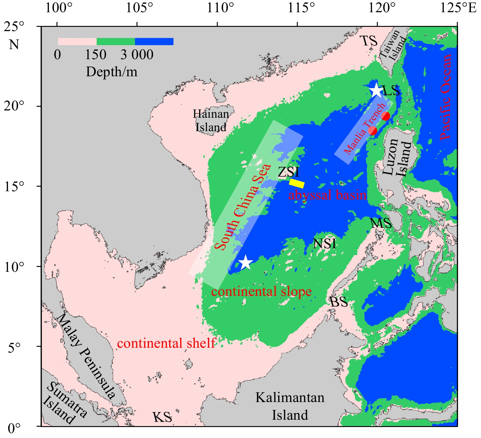
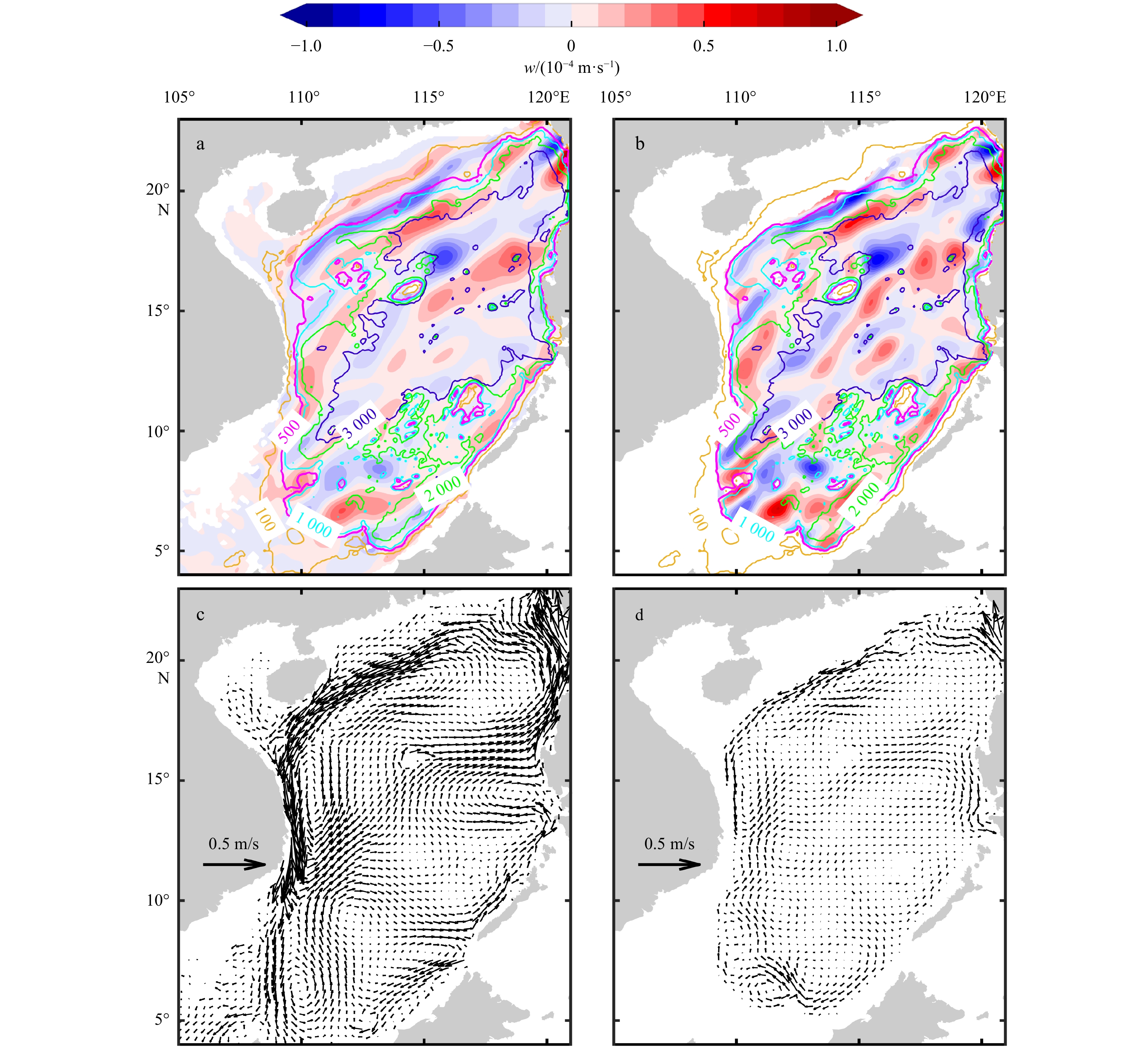
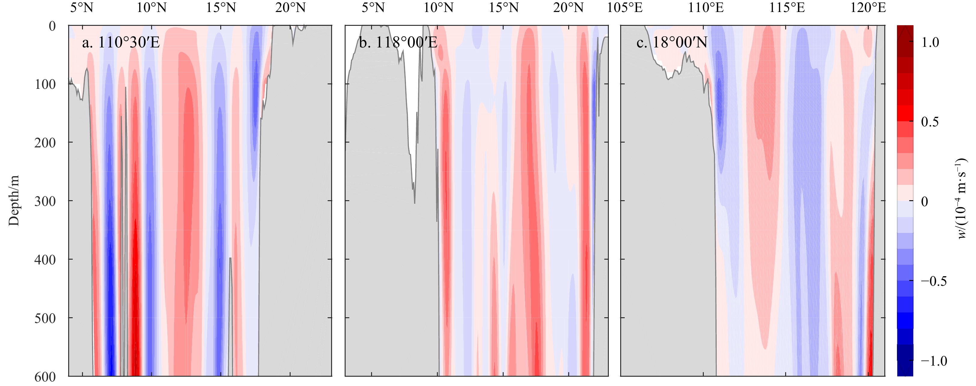
Deep water in the South China Sea is renewed by the cold and dense Luzon Strait overflow. However, from where and how the deep water upwells is poorly understood yet. Based on the Hybrid Coordinate Ocean Model reanalysis data, vertical velocity is derived to answer these questions. Domain-integrated vertical velocity is of two maxima, one in the shallow water and the other at depth, and separated by a layer of minimum at the bottom of the thermocline. Further analysis shows that this two-segmented vertical transport is attributed to the vertical compensation of subsurface water to the excessive outflow of shallow water and upward push of the dense Luzon Strait overflow, respectively. In the abyssal basin, the vertical transport increases upward from zero at the depth of 3 500–4 000 m and reaches a maximum of 1.5×10⁶ m3/s at about 1 500 m. Deep water upwells mainly from the northeastern and southwestern ends of the abyssal basin and off the continental slopes. To explain the upward velocity arising from slope breaks, a possible mechanism is proposed that an onshore velocity component can be derived from the deep western boundary current above steep slopes under bottom friction.
Deep water in the South China Sea is renewed by the cold and dense Luzon Strait overflow. However, from where and how the deep water upwells is poorly understood yet. Based on the Hybrid Coordinate Ocean Model reanalysis data, vertical velocity is derived to answer these questions. Domain-integrated vertical velocity is of two maxima, one in the shallow water and the other at depth, and separated by a layer of minimum at the bottom of the thermocline. Further analysis shows that this two-segmented vertical transport is attributed to the vertical compensation of subsurface water to the excessive outflow of shallow water and upward push of the dense Luzon Strait overflow, respectively. In the abyssal basin, the vertical transport increases upward from zero at the depth of 3 500–4 000 m and reaches a maximum of 1.5×10⁶ m3/s at about 1 500 m. Deep water upwells mainly from the northeastern and southwestern ends of the abyssal basin and off the continental slopes. To explain the upward velocity arising from slope breaks, a possible mechanism is proposed that an onshore velocity component can be derived from the deep western boundary current above steep slopes under bottom friction.


2022, 41(7): 26-41.
doi: 10.1007/s13131-022-2014-4
Abstract:
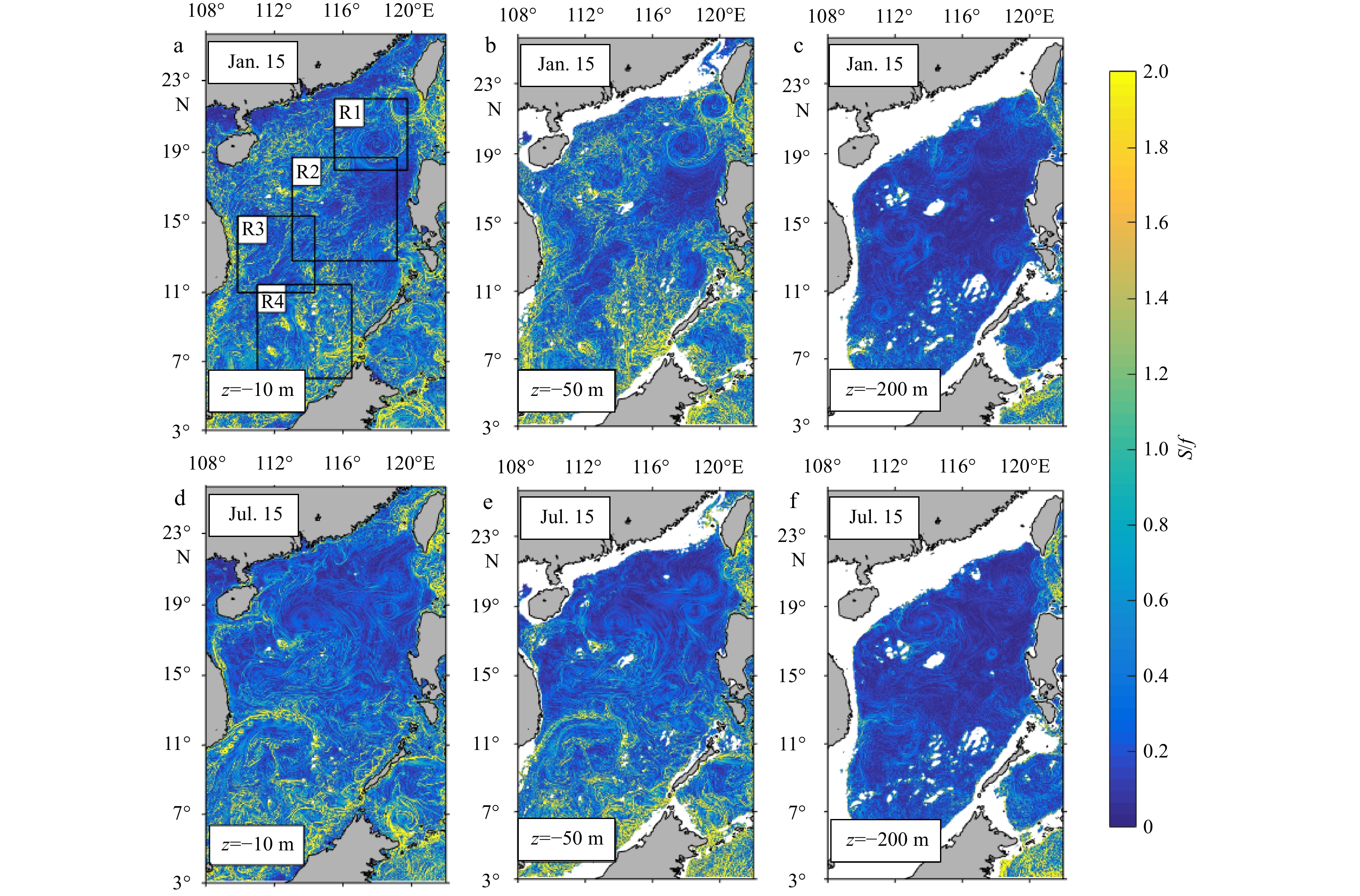
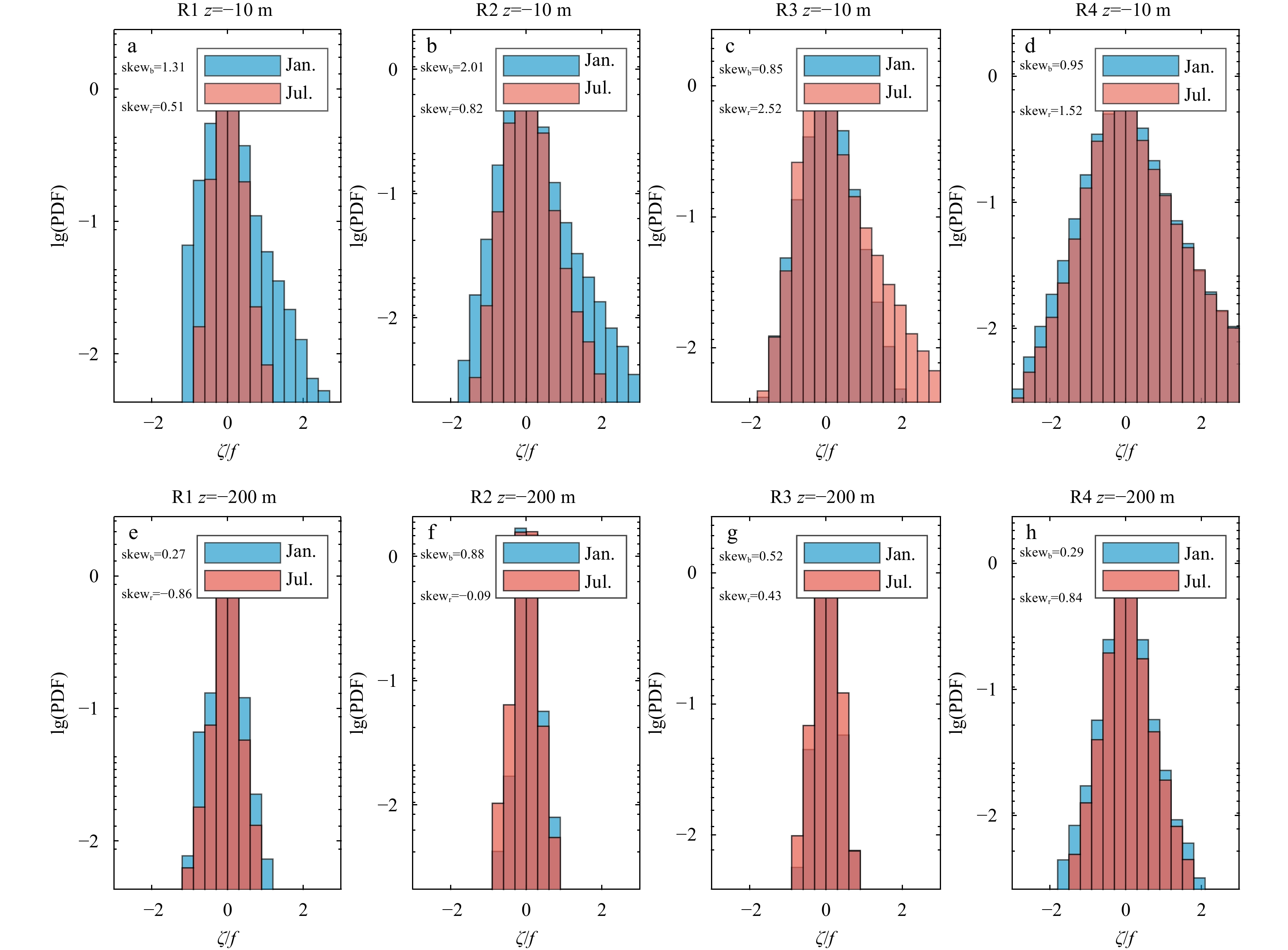
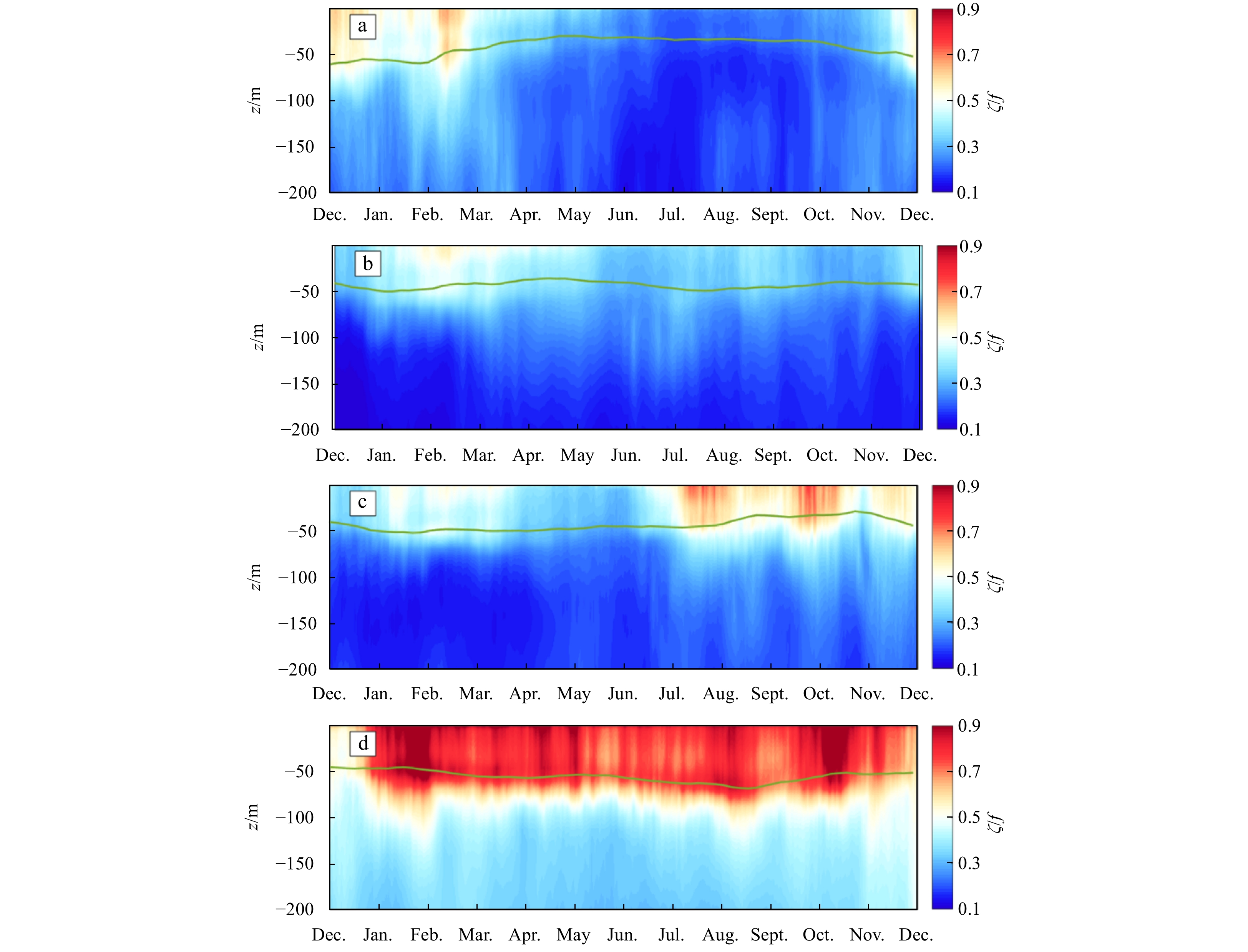
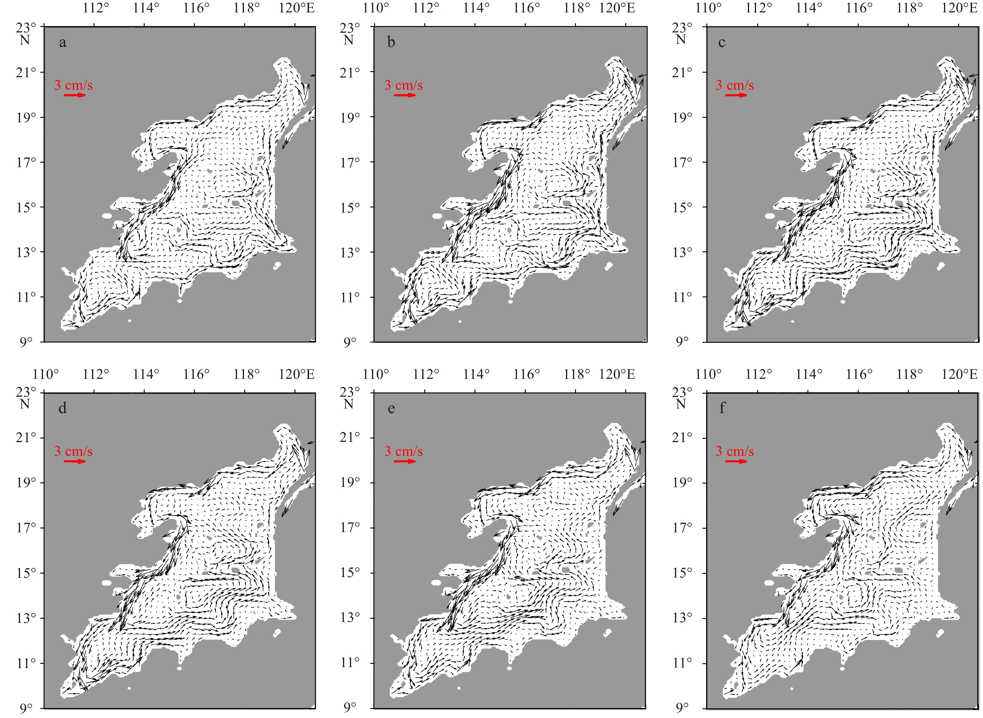
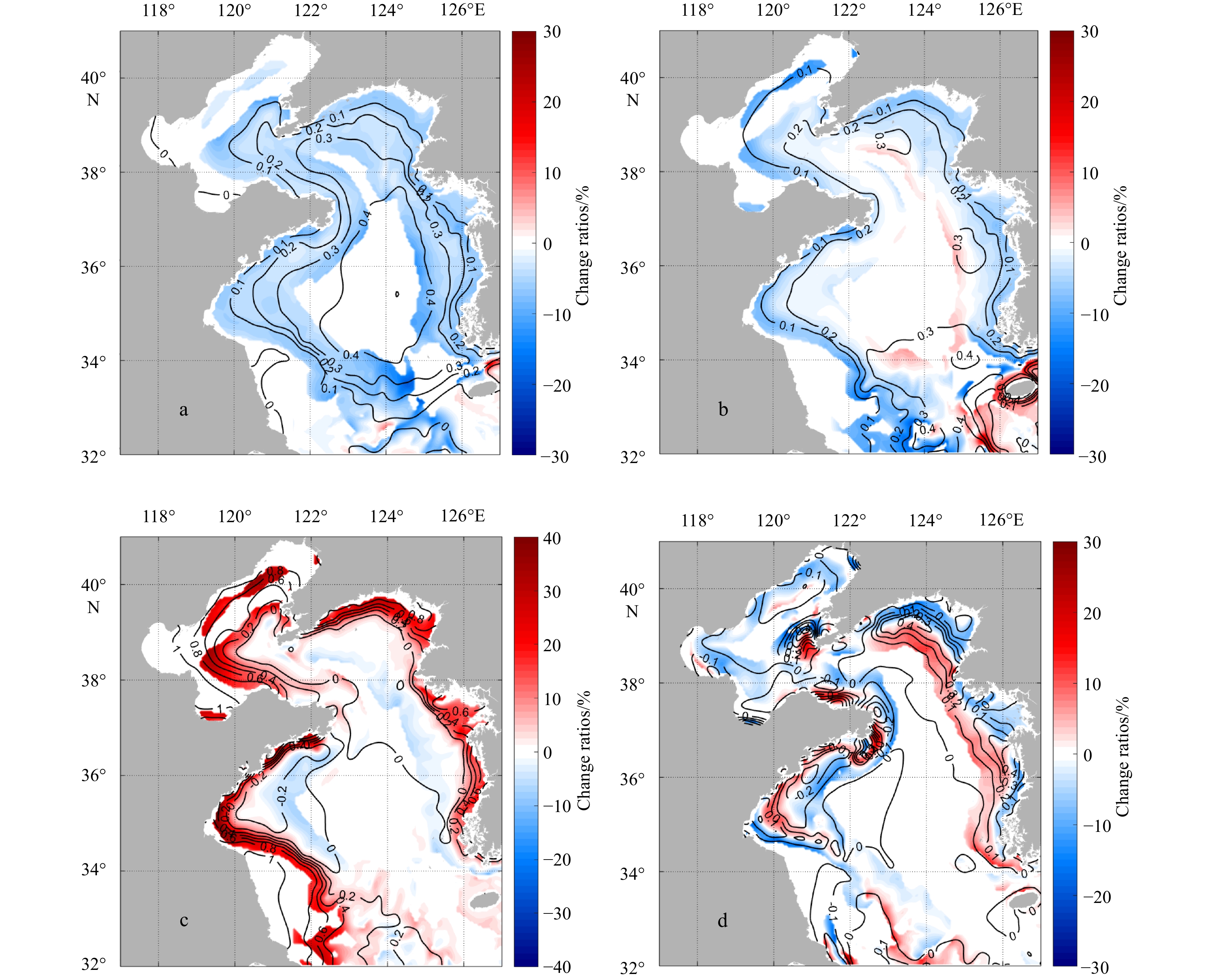
Submesoscale processes in marginal seas usually have complex generating mechanisms, highly dependent on the local background flow and forcing. This numerical study investigates the spatial and seasonal differences of submesoscale activities in the upper ocean of the South China Sea (SCS) and the different dynamical regimes for sub-regions. The spatial and seasonal variations of vertical vorticity, horizontal convergence, lateral buoyancy gradient, and strain rate are analyzed to compare the submesoscale phenomenon within four sub-regions, the northern region near the Luzon Strait (R1), the middle ocean basin (R2), the western SCS (R3), and the southern SCS (R4). The results suggest that the SCS submesoscale processes are highly heterogeneous in space, with different seasonalities in each sub-region. The submesoscale activities in the northern sub-regions (R1, R2) are active in winter but weak in summer, while there appears an almost seasonal anti-phase in the western region (R3) compared to R1 and R2. Interestingly, no clear seasonality of submesoscale features is shown in the southern region (R4). Further analysis of Ertel potential vorticity reveals different generating mechanisms of submesoscale processes in different sub-regions. Correlation analyses also show the vertical extent of vertical velocity and the role of monsoon in generating submesoscale activities in the upper ocean of sub-regions. All these results suggest that the sub-regions have different regimes for submesoscale processes, e.g., Kuroshio intrusion (R1), monsoon modulation (R2), frontal effects (R3), topography wakes (R4).
Submesoscale processes in marginal seas usually have complex generating mechanisms, highly dependent on the local background flow and forcing. This numerical study investigates the spatial and seasonal differences of submesoscale activities in the upper ocean of the South China Sea (SCS) and the different dynamical regimes for sub-regions. The spatial and seasonal variations of vertical vorticity, horizontal convergence, lateral buoyancy gradient, and strain rate are analyzed to compare the submesoscale phenomenon within four sub-regions, the northern region near the Luzon Strait (R1), the middle ocean basin (R2), the western SCS (R3), and the southern SCS (R4). The results suggest that the SCS submesoscale processes are highly heterogeneous in space, with different seasonalities in each sub-region. The submesoscale activities in the northern sub-regions (R1, R2) are active in winter but weak in summer, while there appears an almost seasonal anti-phase in the western region (R3) compared to R1 and R2. Interestingly, no clear seasonality of submesoscale features is shown in the southern region (R4). Further analysis of Ertel potential vorticity reveals different generating mechanisms of submesoscale processes in different sub-regions. Correlation analyses also show the vertical extent of vertical velocity and the role of monsoon in generating submesoscale activities in the upper ocean of sub-regions. All these results suggest that the sub-regions have different regimes for submesoscale processes, e.g., Kuroshio intrusion (R1), monsoon modulation (R2), frontal effects (R3), topography wakes (R4).


2022, 41(7): 42-53.
doi: 10.1007/s13131-021-1971-3
Abstract:
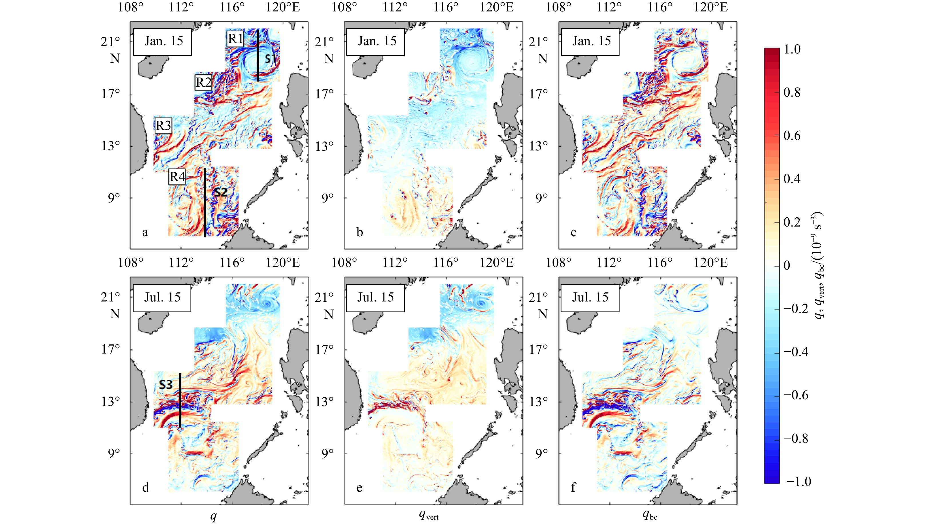
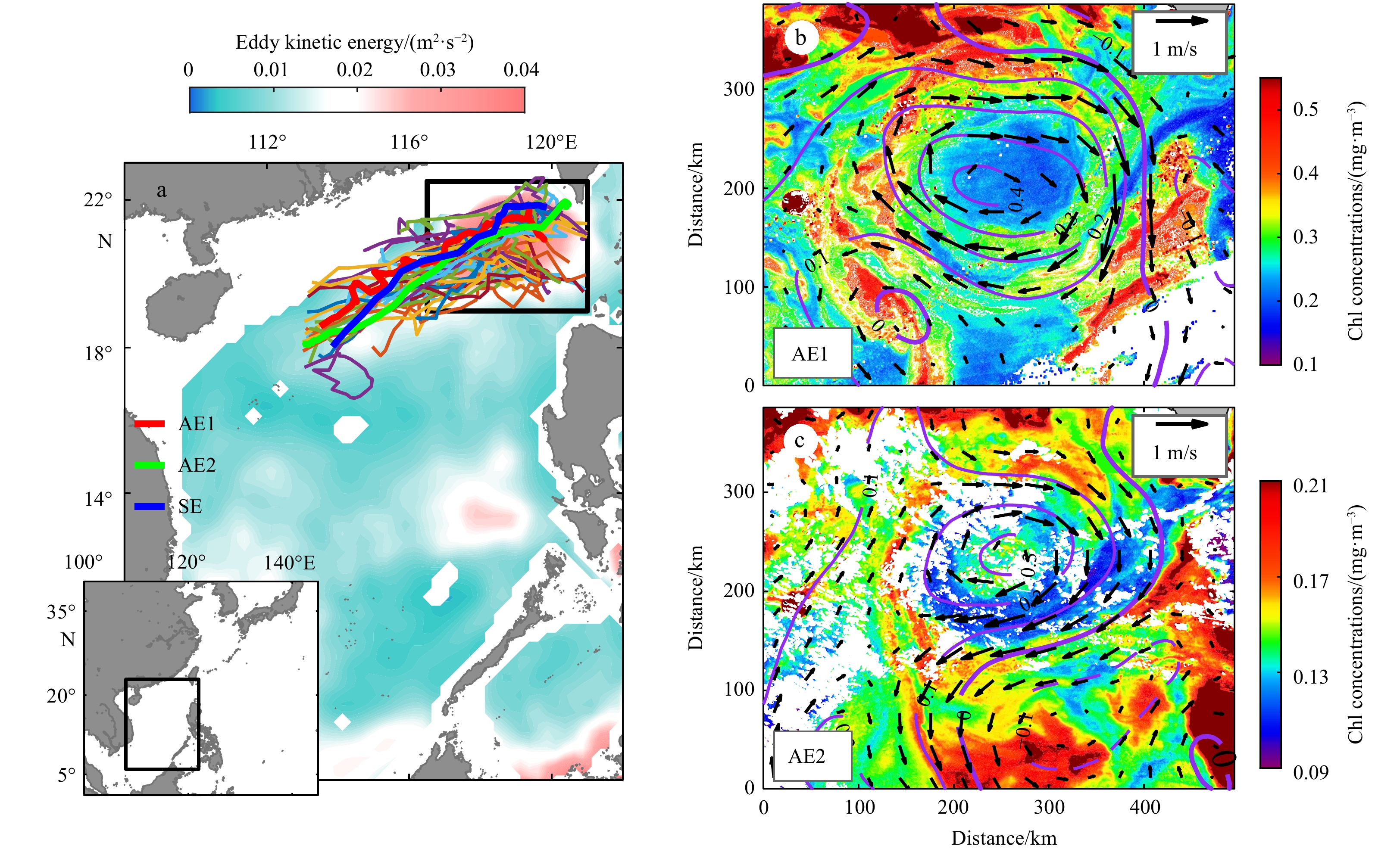
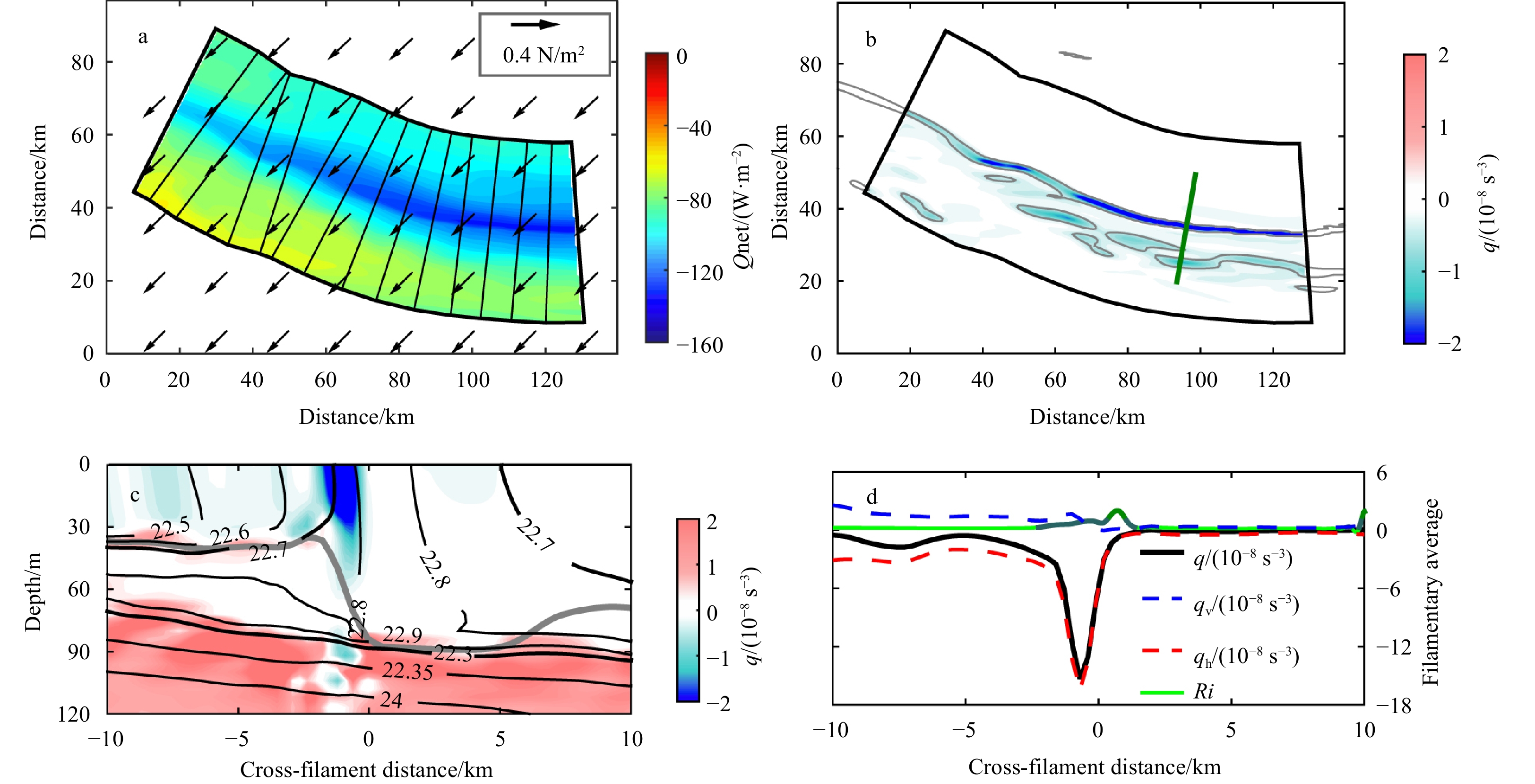
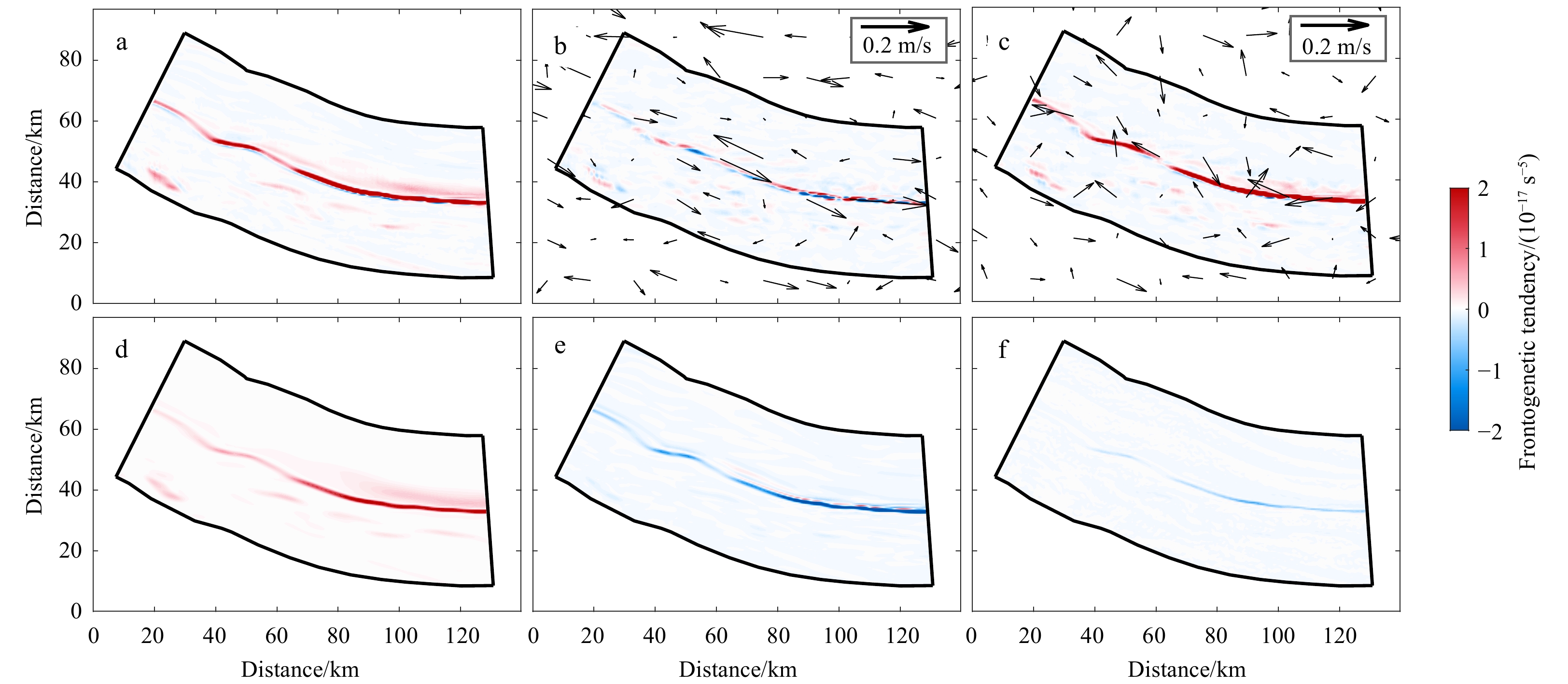
Submesoscale activity in the upper ocean has received intense studies through simulations and observations in the last decade, but in the eddy-active South China Sea (SCS) the fine-scale dynamical processes of submesoscale behaviors and their potential impacts have not been well understood. This study focuses on the elongated filaments of an eddy field in the northern SCS and investigates submesoscale-enhanced vertical motions and the underlying mechanism using satellite-derived observations and a high-resolution (~500 m) simulation. The satellite images show that the elongated highly productive stripes with a typical lateral scale of ~25 km and associated filaments are frequently observed at the periphery of mesoscale eddies. The diagnostic results based on the 500 m-resolution realistic simulation indicate that these submesoscale filaments are characterized by cross-filament vertical secondary circulations with an increased vertical velocity reaching O(100 m/d) due to submesoscale instabilities. The vertical advections of secondary circulations drive a restratified vertical buoyancy flux along filament zones and induce a vertical heat flux up to 110 W/m2. This result implies a significant submesoscale-enhanced vertical exchange between the ocean surface and interior in the filaments. Frontogenesis that acts to sharpen the lateral buoyancy gradients is detected to be conducive to driving submesoscale instabilities and enhancing secondary circulations through increasing the filament baroclinicity. The further analysis indicates that the filament frontogenesis detected in this study is not only derived from mesoscale straining of the eddy, but also effectively induced by the subsequent submesoscale straining due to ageostrophic convergence. In this context, these submesoscale filaments and associated frontogenetic processes can provide a potential interpretation for the vertical nutrient supply for phytoplankton growth in the high-productive stripes within the mesoscale eddy, as well as enhanced vertical heat transport.
Submesoscale activity in the upper ocean has received intense studies through simulations and observations in the last decade, but in the eddy-active South China Sea (SCS) the fine-scale dynamical processes of submesoscale behaviors and their potential impacts have not been well understood. This study focuses on the elongated filaments of an eddy field in the northern SCS and investigates submesoscale-enhanced vertical motions and the underlying mechanism using satellite-derived observations and a high-resolution (~500 m) simulation. The satellite images show that the elongated highly productive stripes with a typical lateral scale of ~25 km and associated filaments are frequently observed at the periphery of mesoscale eddies. The diagnostic results based on the 500 m-resolution realistic simulation indicate that these submesoscale filaments are characterized by cross-filament vertical secondary circulations with an increased vertical velocity reaching O(100 m/d) due to submesoscale instabilities. The vertical advections of secondary circulations drive a restratified vertical buoyancy flux along filament zones and induce a vertical heat flux up to 110 W/m2. This result implies a significant submesoscale-enhanced vertical exchange between the ocean surface and interior in the filaments. Frontogenesis that acts to sharpen the lateral buoyancy gradients is detected to be conducive to driving submesoscale instabilities and enhancing secondary circulations through increasing the filament baroclinicity. The further analysis indicates that the filament frontogenesis detected in this study is not only derived from mesoscale straining of the eddy, but also effectively induced by the subsequent submesoscale straining due to ageostrophic convergence. In this context, these submesoscale filaments and associated frontogenetic processes can provide a potential interpretation for the vertical nutrient supply for phytoplankton growth in the high-productive stripes within the mesoscale eddy, as well as enhanced vertical heat transport.


2022, 41(7): 54-64.
doi: 10.1007/s13131-021-1952-6
Abstract:
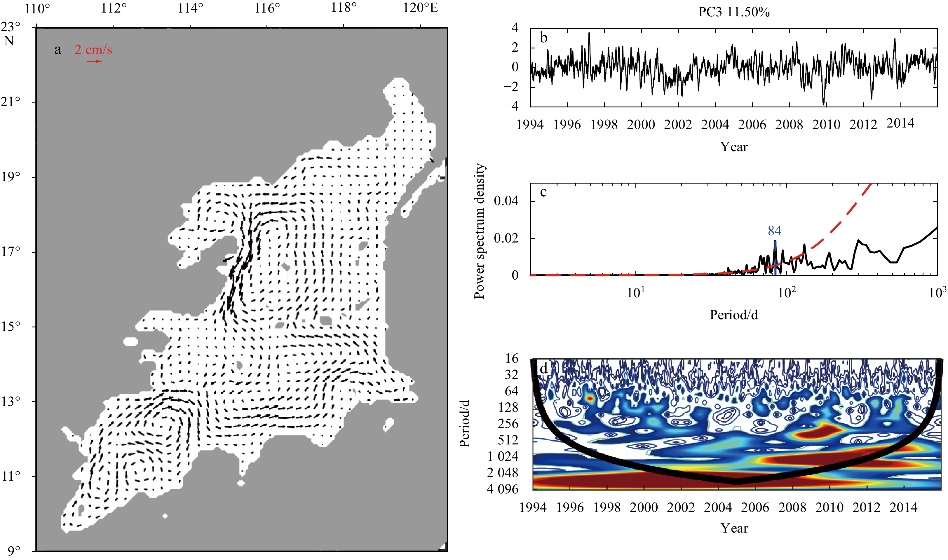
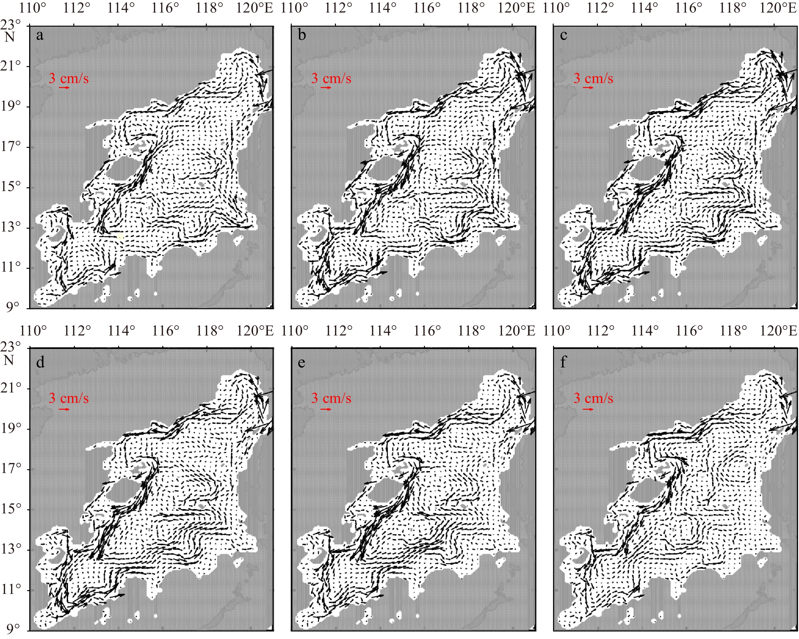
This study aims to investigate variability of the deep South China Sea (SCS) circulation using the Hybrid Coordinate Ocean Model (HYCOM) global reanalysis product. The results reveal that annual cycle is a dominant component in the deep SCS circulation. Meanwhile, the boundary circulation strength is the weakest in January and peaks between June and September. The eastern and southern boundary currents strengthen/weaken one to three months earlier than that in the western and northern boundaries. Vector Empirical Orthogonal Functions (VEOF) analysis results reveal that semiannual and intraseasonal fluctuations are significant components, of which the spatial patterns are mainly confined in the northern and western boundary areas as well as the southwestern sub-basin. Wavelet analysis results show the strength of significant fluctuation varies year to year. Trend analysis results indicate a decadal weakening in the deep SCS circulation. An anomalous anticyclonic circulation, 50–70 km apart from the slope break, tends to weaken the cyclonic boundary circulation in the western and northern boundaries as well as the southwestern sub-basin. This trend is similar to the observed decadal weakening in the North Atlantic deep circulation. Thus, the findings of this study reveal that the variation of the deep SCS circulation has a remarkable response to the climate change. The mechanisms responsible for the variation are worth pursuing if more observations are available.
This study aims to investigate variability of the deep South China Sea (SCS) circulation using the Hybrid Coordinate Ocean Model (HYCOM) global reanalysis product. The results reveal that annual cycle is a dominant component in the deep SCS circulation. Meanwhile, the boundary circulation strength is the weakest in January and peaks between June and September. The eastern and southern boundary currents strengthen/weaken one to three months earlier than that in the western and northern boundaries. Vector Empirical Orthogonal Functions (VEOF) analysis results reveal that semiannual and intraseasonal fluctuations are significant components, of which the spatial patterns are mainly confined in the northern and western boundary areas as well as the southwestern sub-basin. Wavelet analysis results show the strength of significant fluctuation varies year to year. Trend analysis results indicate a decadal weakening in the deep SCS circulation. An anomalous anticyclonic circulation, 50–70 km apart from the slope break, tends to weaken the cyclonic boundary circulation in the western and northern boundaries as well as the southwestern sub-basin. This trend is similar to the observed decadal weakening in the North Atlantic deep circulation. Thus, the findings of this study reveal that the variation of the deep SCS circulation has a remarkable response to the climate change. The mechanisms responsible for the variation are worth pursuing if more observations are available.


2022, 41(7): 65-77.
doi: 10.1007/s13131-021-1975-z
Abstract:
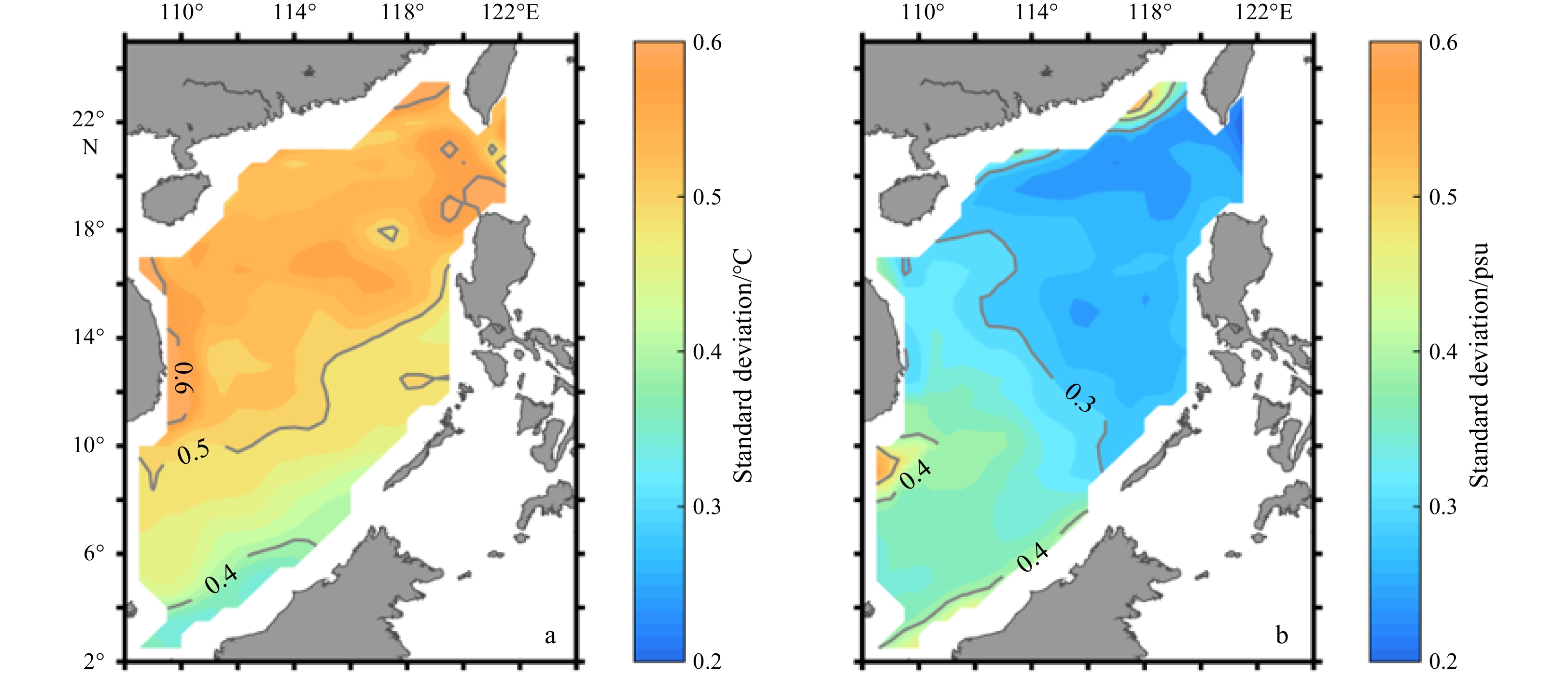
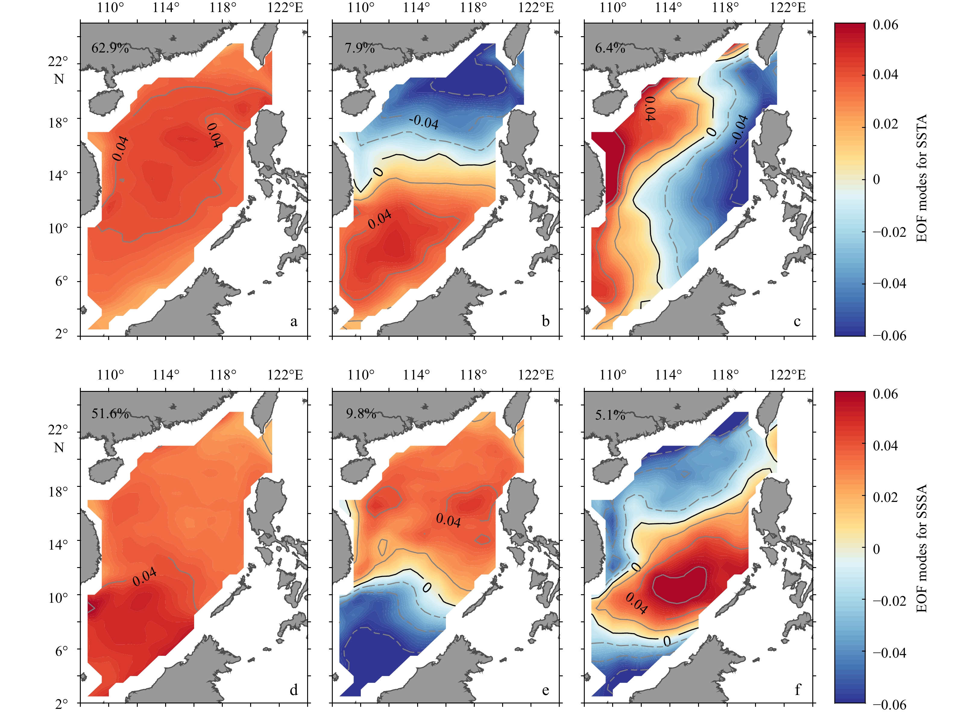
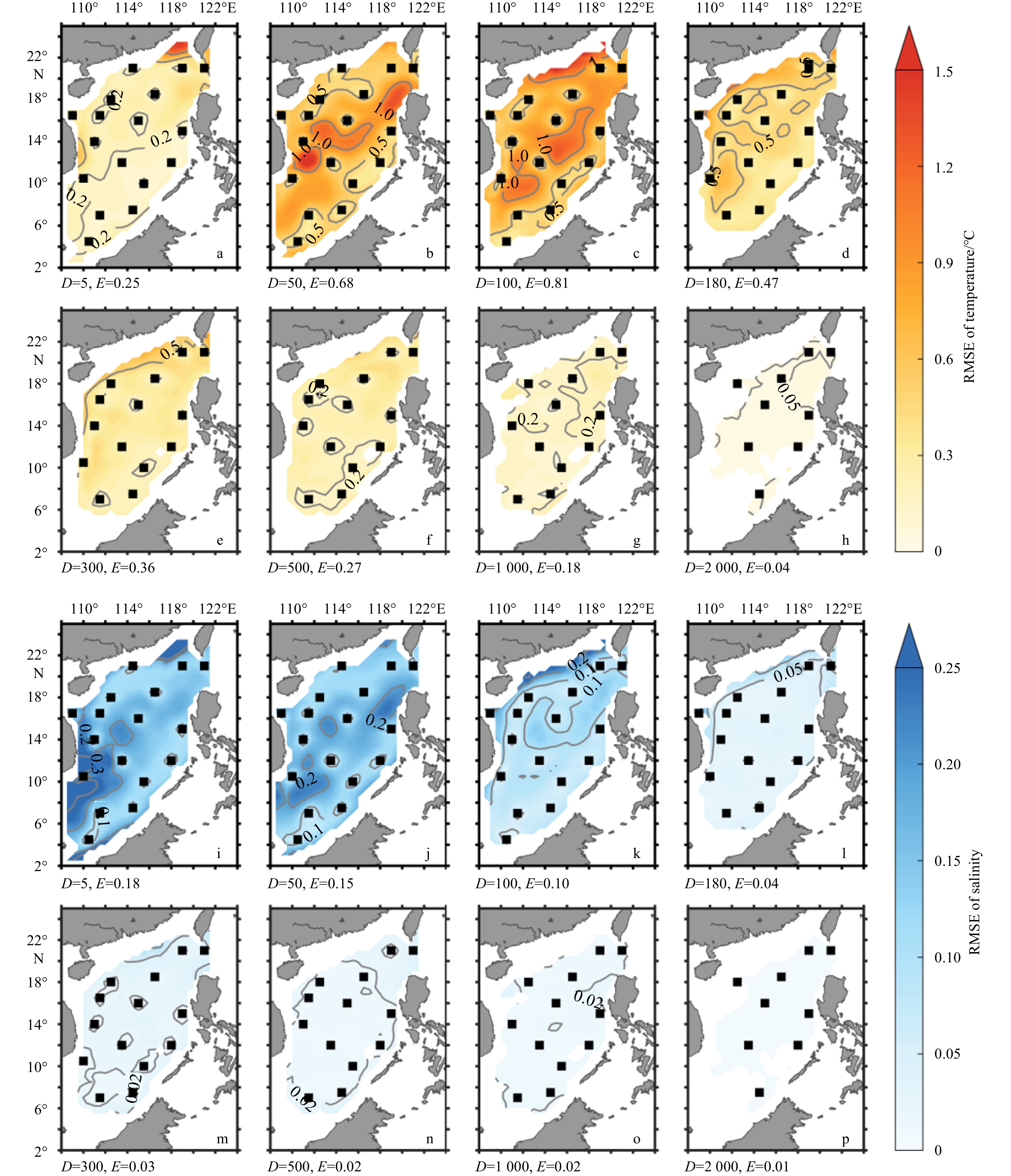
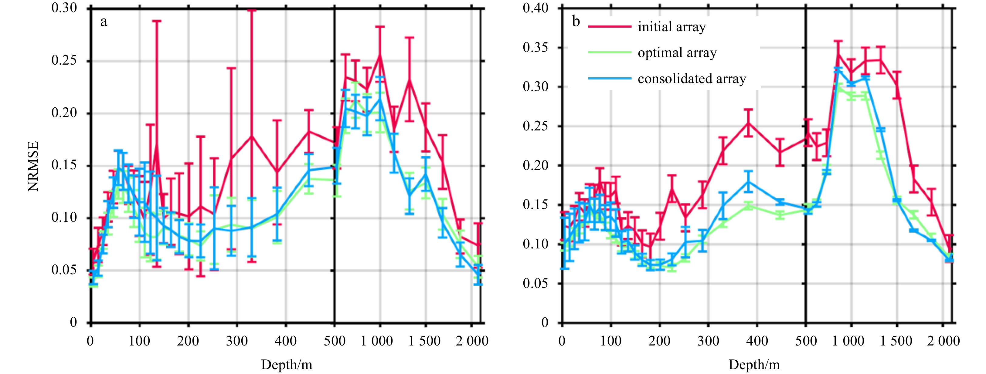
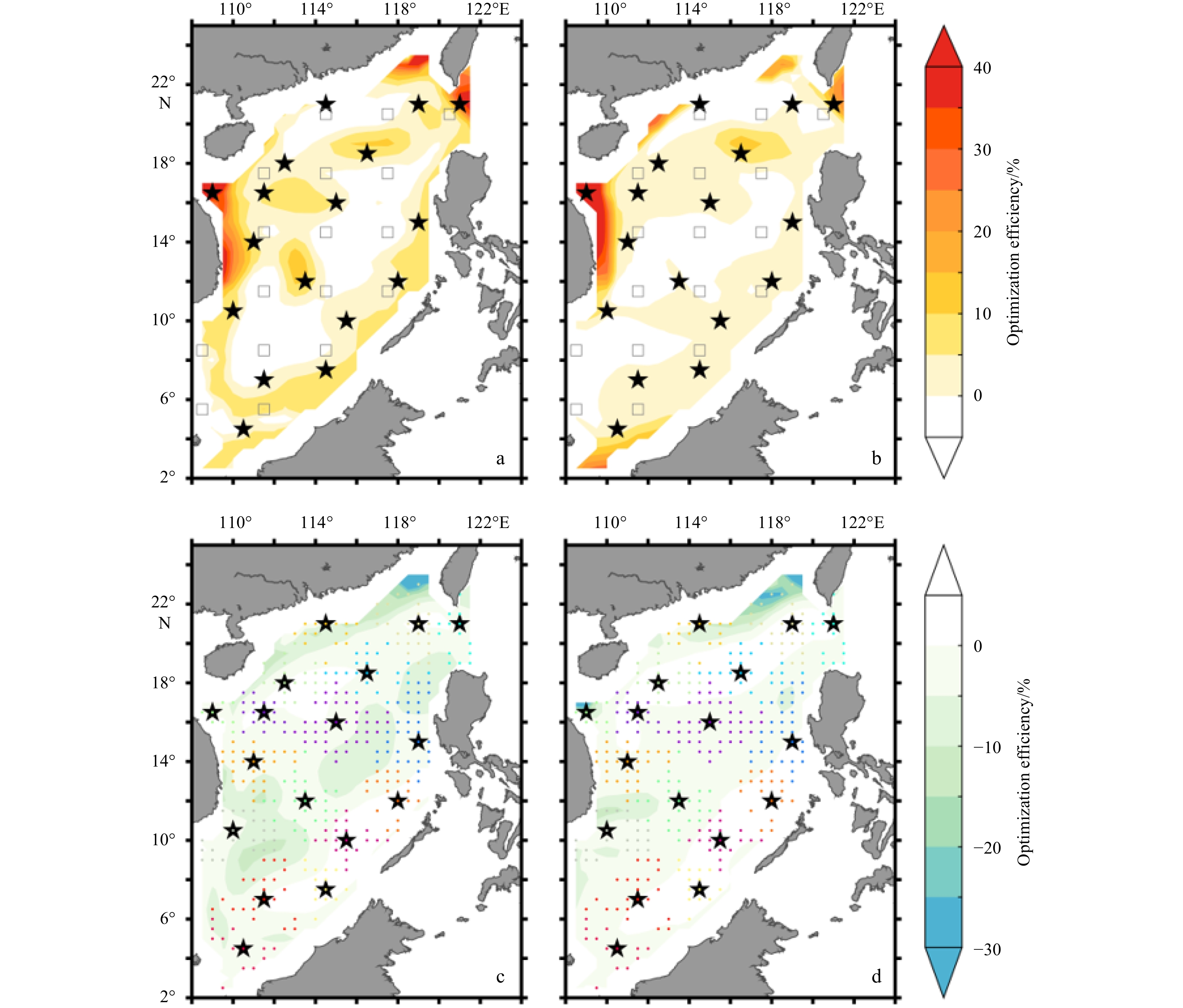
In this study, a moored array optimization tool (MAOT) was developed and applied to the South China Sea (SCS) with a focus on three-dimensional temperature and salinity observations. Application of the MAOT involves two steps: (1) deriving a set of optimal arrays that are independent of each other for different variables at different depths based on an empirical orthogonal function method, and (2) consolidating these arrays using a K-center clustering algorithm. Compared with the assumed initial array consisting of 17 mooring sites located on a 3°×3° horizontal grid, the consolidated array improved the observing ability for three-dimensional temperature and salinity in the SCS with optimization efficiencies of 19.03% and 21.38%, respectively. Experiments with an increased number of moored sites showed that the most cost-effective option is a total of 20 moorings, improving the observing ability with optimization efficiencies up to 26.54% for temperature and 27.25% for salinity. The design of an objective array relies on the ocean phenomenon of interest and its spatial and temporal scales. In this study, we focus on basin-scale variations in temperature and salinity in the SCS, and thus our consolidated array may not well resolve mesoscale processes. The MAOT can be extended to include other variables and multi-scale variability and can be applied to other regions.
In this study, a moored array optimization tool (MAOT) was developed and applied to the South China Sea (SCS) with a focus on three-dimensional temperature and salinity observations. Application of the MAOT involves two steps: (1) deriving a set of optimal arrays that are independent of each other for different variables at different depths based on an empirical orthogonal function method, and (2) consolidating these arrays using a K-center clustering algorithm. Compared with the assumed initial array consisting of 17 mooring sites located on a 3°×3° horizontal grid, the consolidated array improved the observing ability for three-dimensional temperature and salinity in the SCS with optimization efficiencies of 19.03% and 21.38%, respectively. Experiments with an increased number of moored sites showed that the most cost-effective option is a total of 20 moorings, improving the observing ability with optimization efficiencies up to 26.54% for temperature and 27.25% for salinity. The design of an objective array relies on the ocean phenomenon of interest and its spatial and temporal scales. In this study, we focus on basin-scale variations in temperature and salinity in the SCS, and thus our consolidated array may not well resolve mesoscale processes. The MAOT can be extended to include other variables and multi-scale variability and can be applied to other regions.


2022, 41(7): 78-83.
doi: 10.1007/s13131-022-2032-2
Abstract:
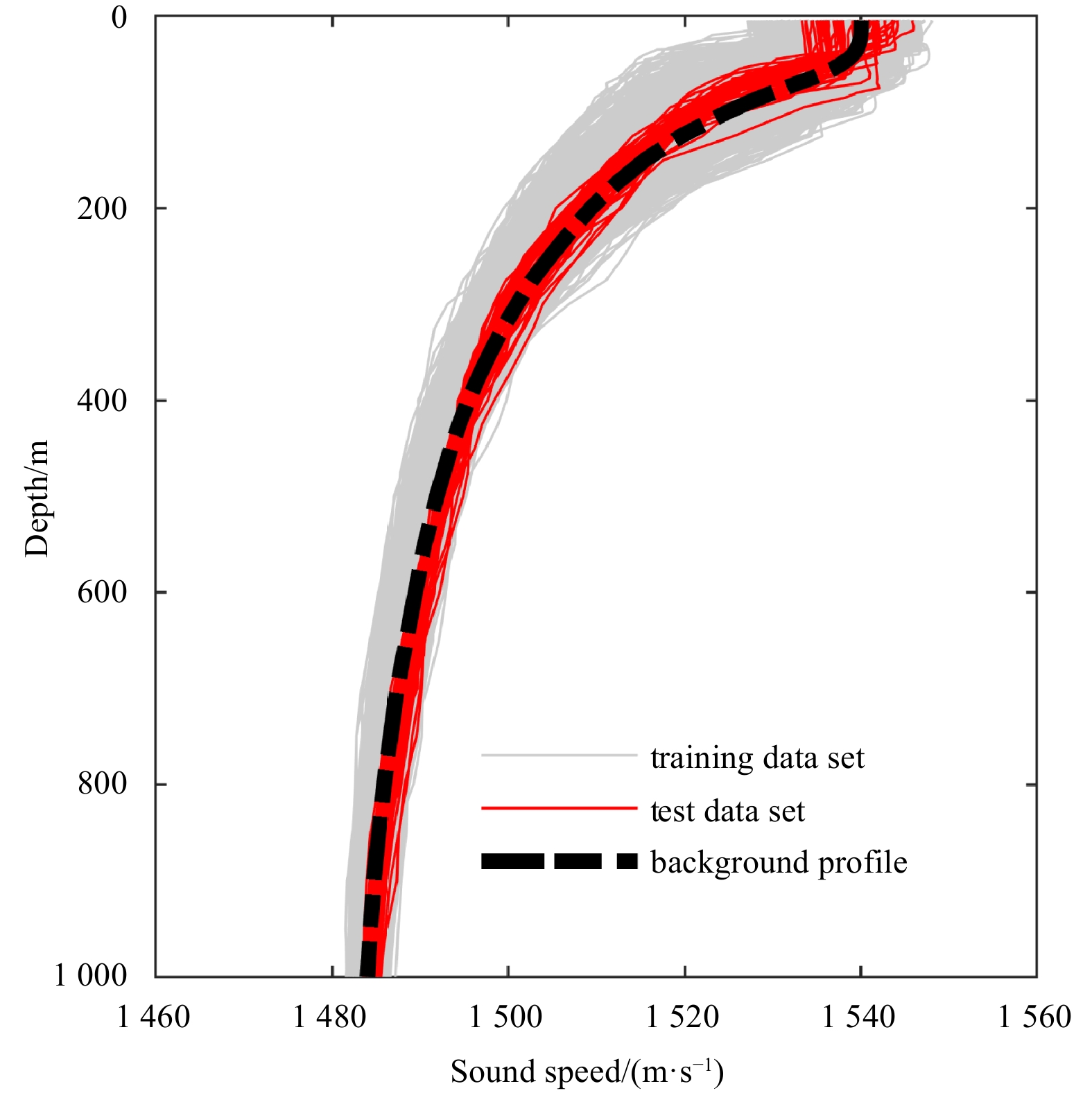
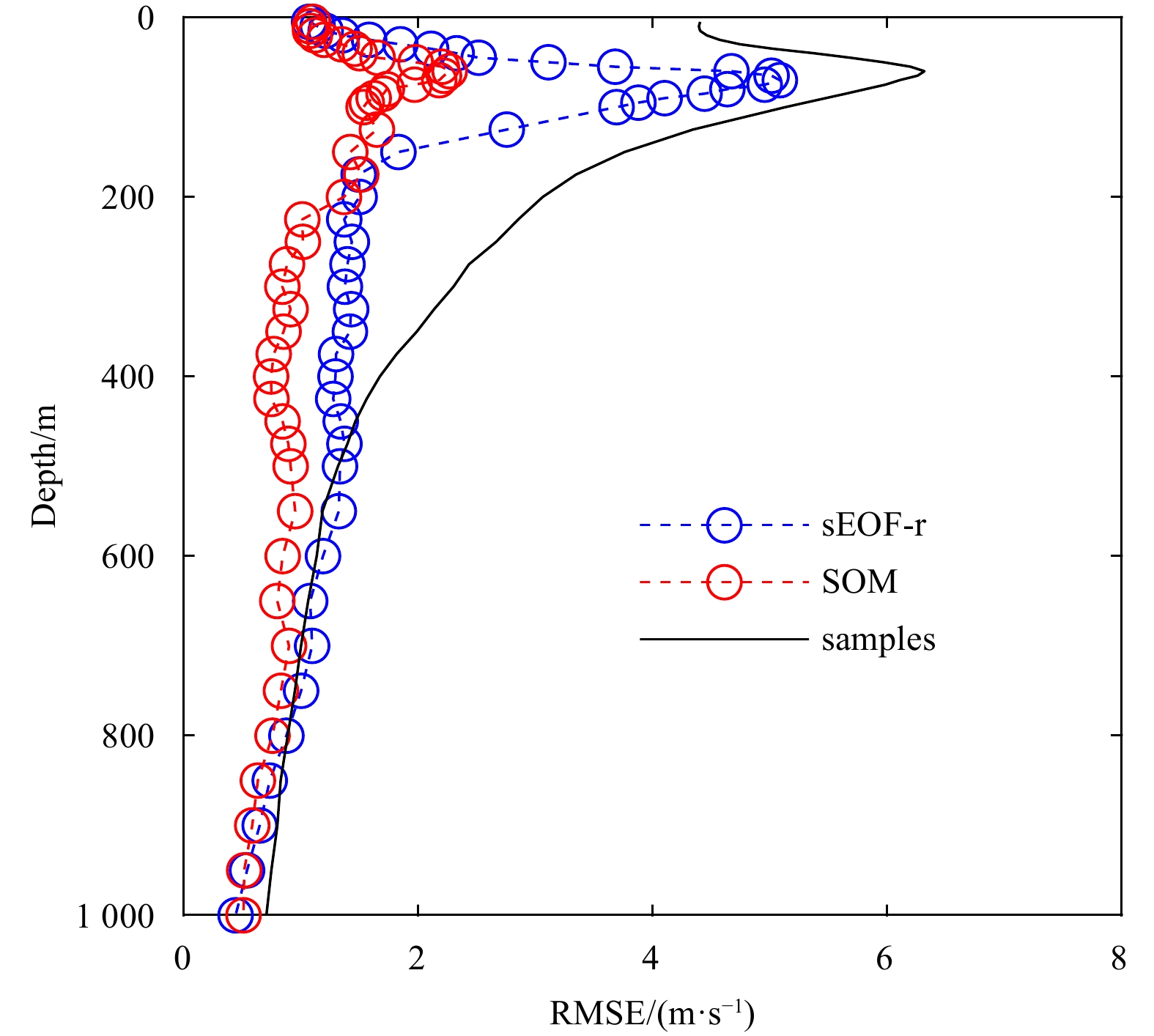
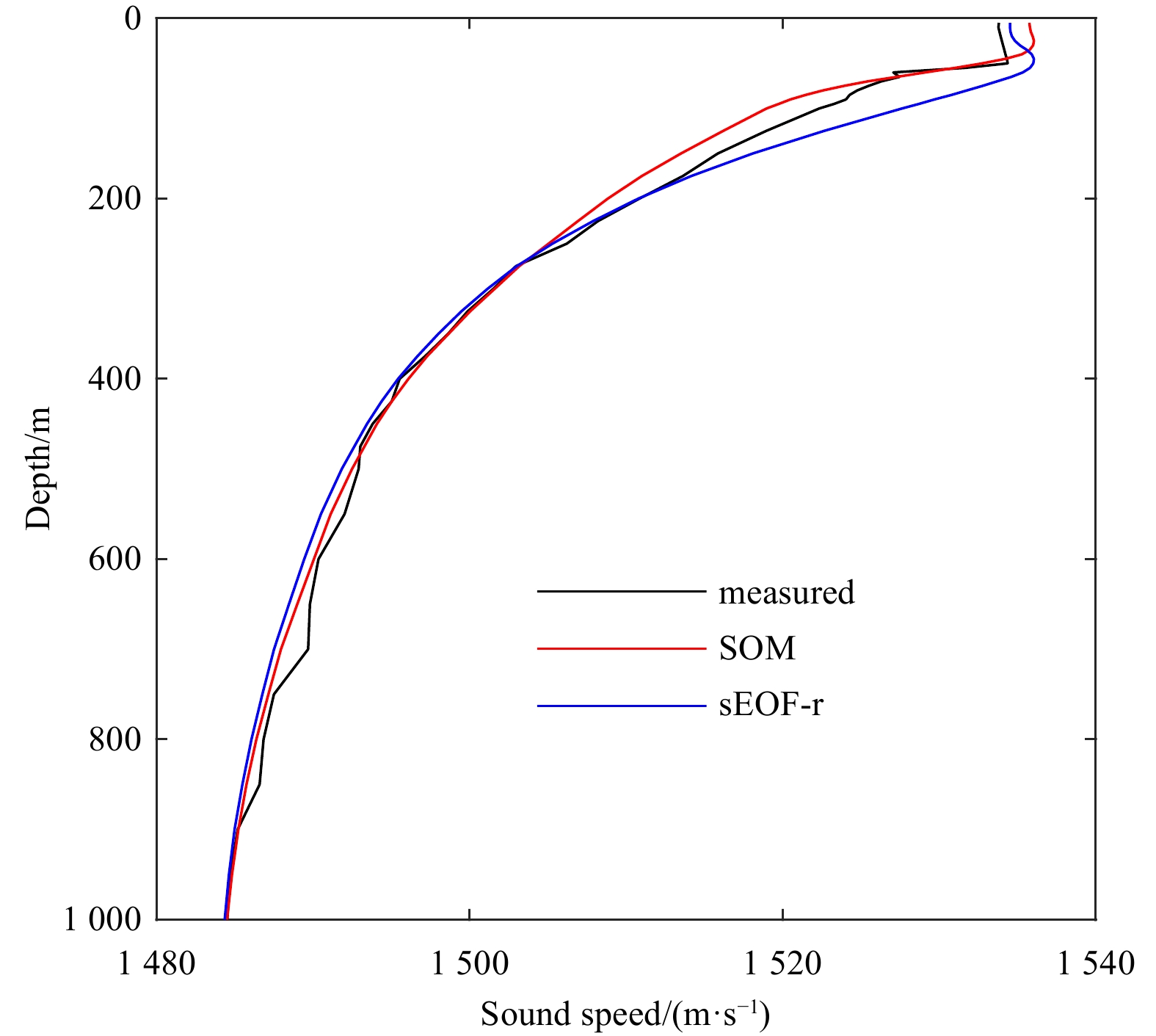
Complex perturbations in the profile and the sparsity of samples often limit the validity of rapid environmental assessment (REA) in the South China Sea (SCS). In this paper, the remote sensing data were used to estimate sound speed profile (SSP) with the self-organizing map (SOM) method in the SCS. First, the consistency of the empirical orthogonal functions was examined by using k-means clustering. The clustering results indicated that SSPs in the SCS have a similar perturbation nature, which means the inverted grid could be expanded to the entire SCS to deal with the problem of sparsity of the samples without statistical improbability. Second, a machine learning method was proposed that took advantage of the topological structure of SOM to significantly improve their accuracy. Validation revealed promising results, with a mean reconstruction error of 1.26 m/s, which is 1.16 m/s smaller than the traditional single empirical orthogonal function regression (sEOF-r) method. By violating the constraints of linear inversion, the topological structure of the SOM method showed a smaller error and better robustness in the SSP estimation. The improvements to enhance the accuracy and robustness of REA in the SCS were offered. These results suggested a potential utilization of REA in the SCS based on satellite data and provided a new approach for SSP estimation derived from sea surface data.
Complex perturbations in the profile and the sparsity of samples often limit the validity of rapid environmental assessment (REA) in the South China Sea (SCS). In this paper, the remote sensing data were used to estimate sound speed profile (SSP) with the self-organizing map (SOM) method in the SCS. First, the consistency of the empirical orthogonal functions was examined by using k-means clustering. The clustering results indicated that SSPs in the SCS have a similar perturbation nature, which means the inverted grid could be expanded to the entire SCS to deal with the problem of sparsity of the samples without statistical improbability. Second, a machine learning method was proposed that took advantage of the topological structure of SOM to significantly improve their accuracy. Validation revealed promising results, with a mean reconstruction error of 1.26 m/s, which is 1.16 m/s smaller than the traditional single empirical orthogonal function regression (sEOF-r) method. By violating the constraints of linear inversion, the topological structure of the SOM method showed a smaller error and better robustness in the SSP estimation. The improvements to enhance the accuracy and robustness of REA in the SCS were offered. These results suggested a potential utilization of REA in the SCS based on satellite data and provided a new approach for SSP estimation derived from sea surface data.


2022, 41(7): 84-96.
doi: 10.1007/s13131-021-1967-z
Abstract:
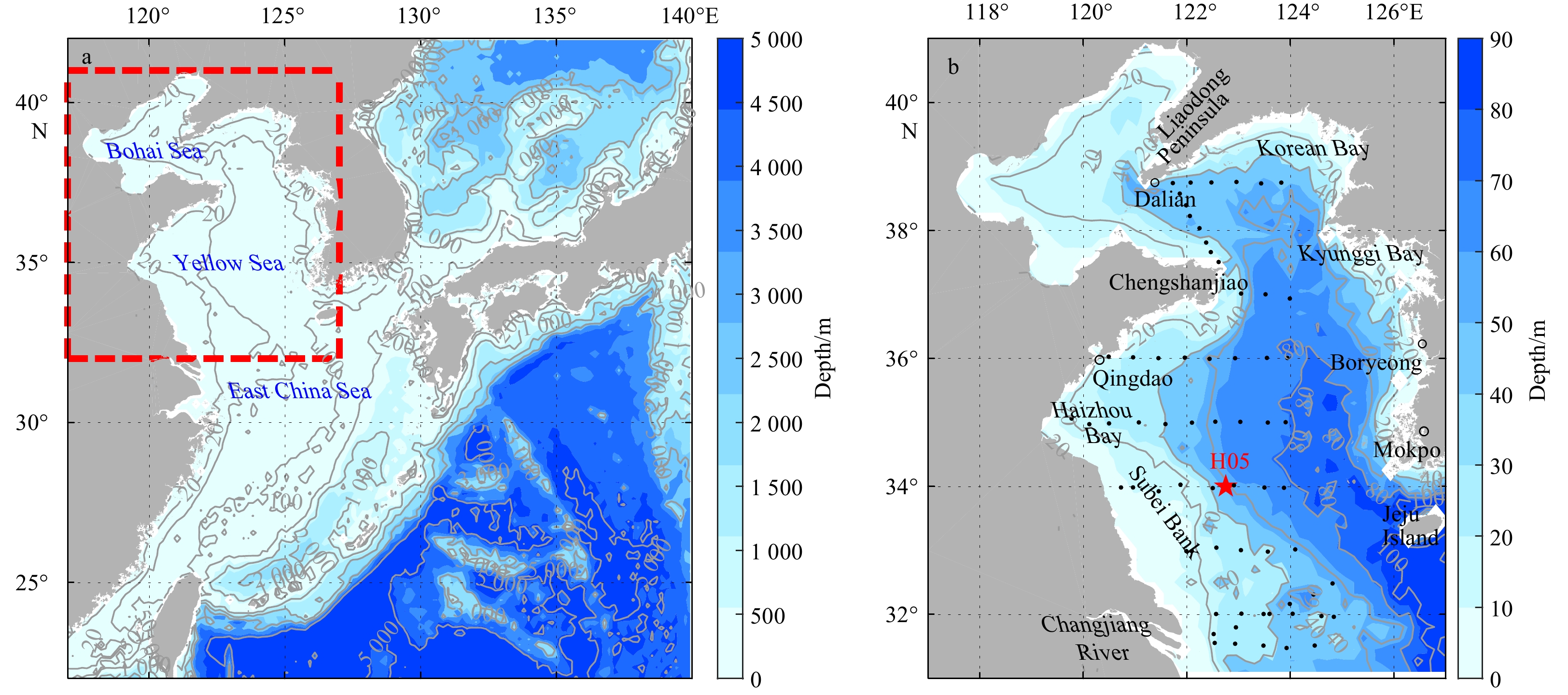
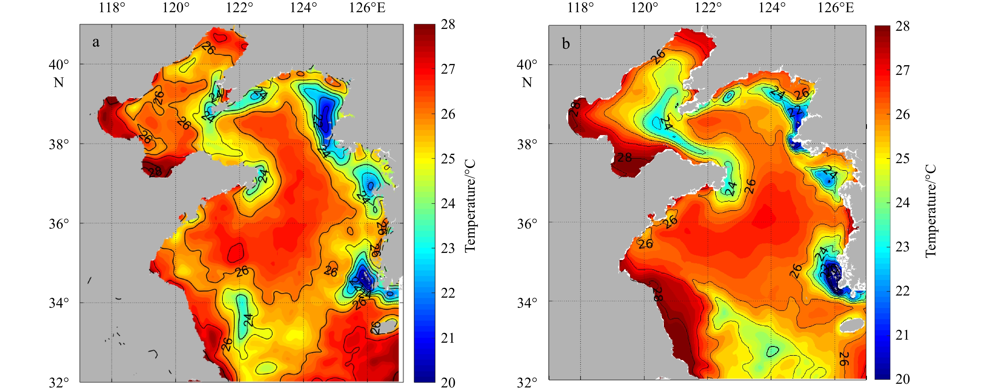
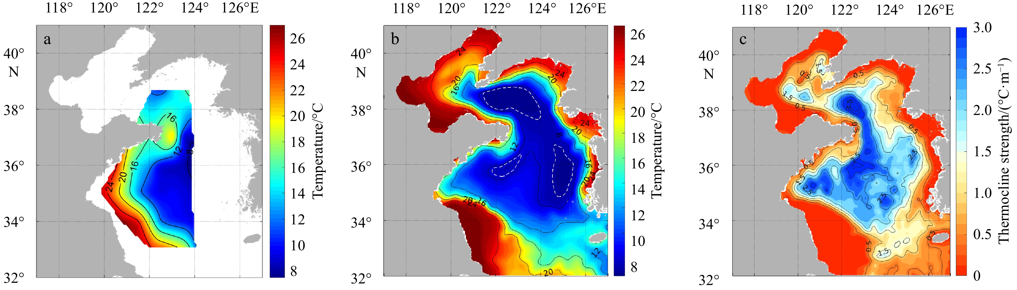
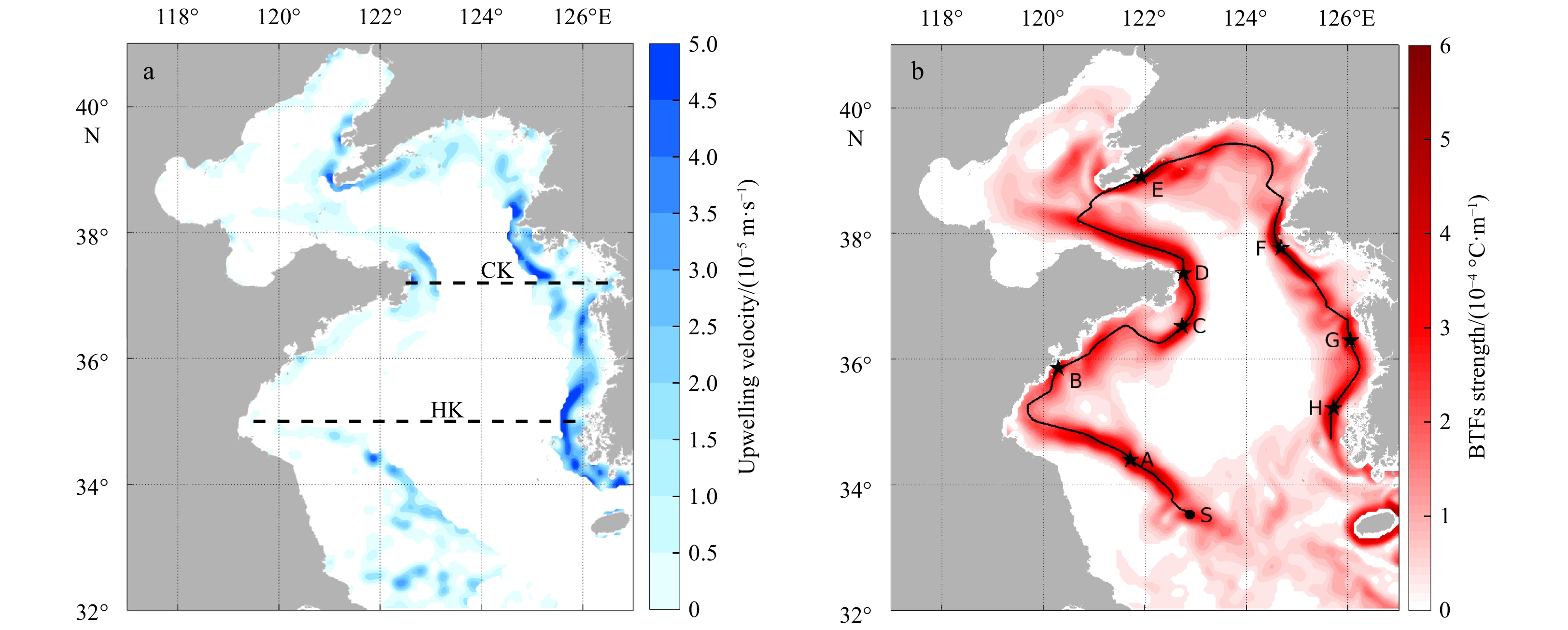
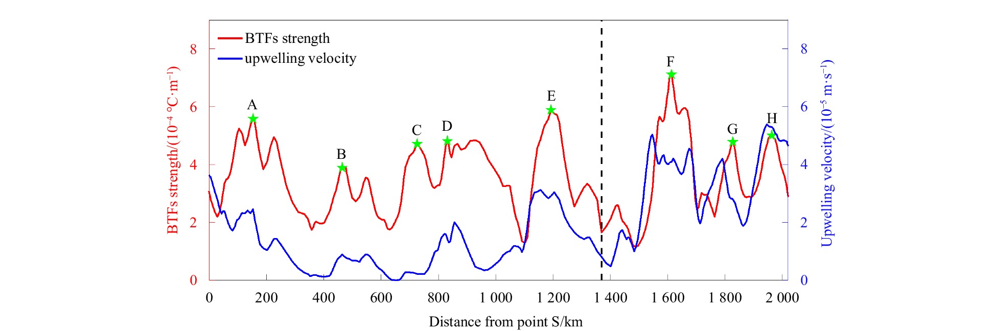
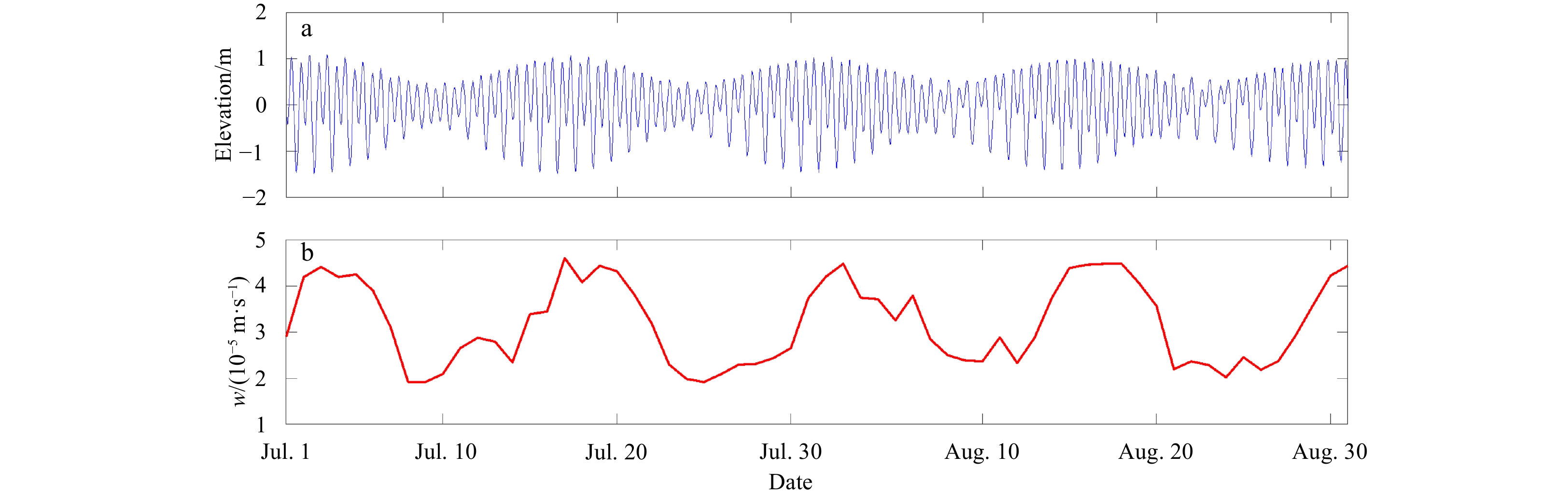
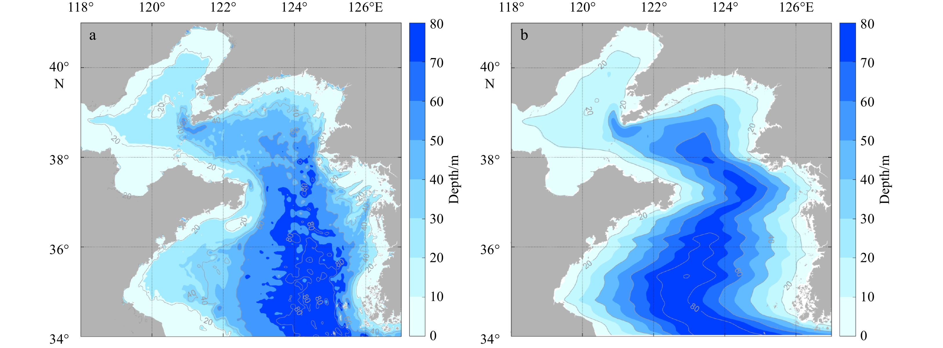
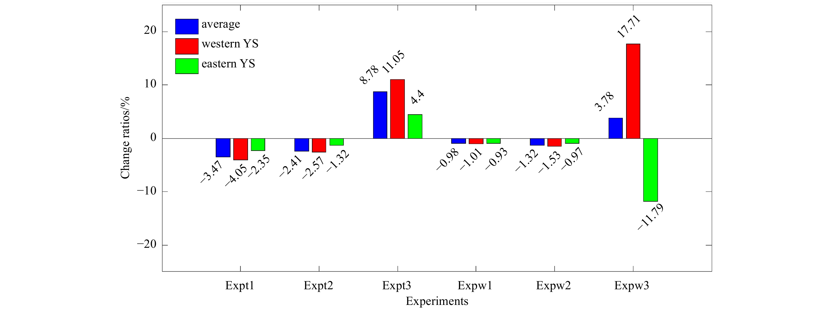
Frontal upwelling is an important phenomenon in summer in the Yellow Sea (YS) and plays an essential role in the distribution of nutrients and biological species. In this paper, a three-dimensional hydrodynamic model is applied to investigate the characteristics and influencing factors of frontal upwelling in the YS. The results show that the strength and distribution of frontal upwelling are largely dependent on the topography and bottom temperature fronts. The frontal upwelling in the YS is stronger and narrower near the eastern coast than near the western coast due to the steeper shelf slope. Moreover, external forcings, such as the meridional wind speed and air temperature in summer and the air temperature in the preceding winter and spring, have certain influences on the strength of frontal upwelling. An increase in air temperature in the previous winter and spring weakens the frontal upwelling in summer; in contrast, an increase in air temperature in summer strengthens the frontal upwelling. When the southerly wind in summer increases, the upwelling intensifies in the western YS and weakens in the eastern YS. The air temperature influences the strength of upwelling by changing the baroclinicity in the frontal region. Furthermore, the meridional wind speed in summer affects frontal upwelling via Ekman pumping.
Frontal upwelling is an important phenomenon in summer in the Yellow Sea (YS) and plays an essential role in the distribution of nutrients and biological species. In this paper, a three-dimensional hydrodynamic model is applied to investigate the characteristics and influencing factors of frontal upwelling in the YS. The results show that the strength and distribution of frontal upwelling are largely dependent on the topography and bottom temperature fronts. The frontal upwelling in the YS is stronger and narrower near the eastern coast than near the western coast due to the steeper shelf slope. Moreover, external forcings, such as the meridional wind speed and air temperature in summer and the air temperature in the preceding winter and spring, have certain influences on the strength of frontal upwelling. An increase in air temperature in the previous winter and spring weakens the frontal upwelling in summer; in contrast, an increase in air temperature in summer strengthens the frontal upwelling. When the southerly wind in summer increases, the upwelling intensifies in the western YS and weakens in the eastern YS. The air temperature influences the strength of upwelling by changing the baroclinicity in the frontal region. Furthermore, the meridional wind speed in summer affects frontal upwelling via Ekman pumping.


2022, 41(7): 97-112.
doi: 10.1007/s13131-021-1974-0
Abstract:
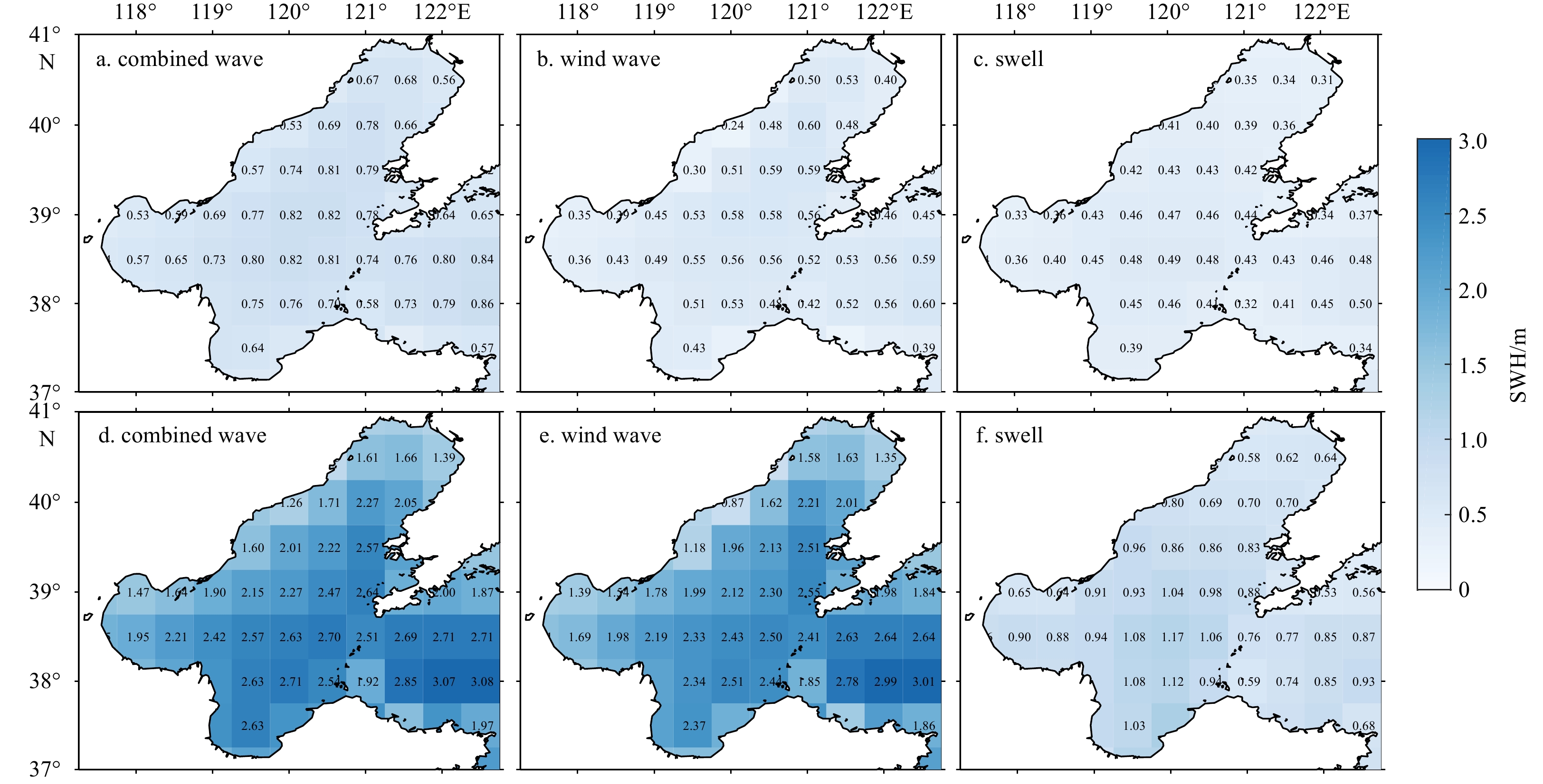
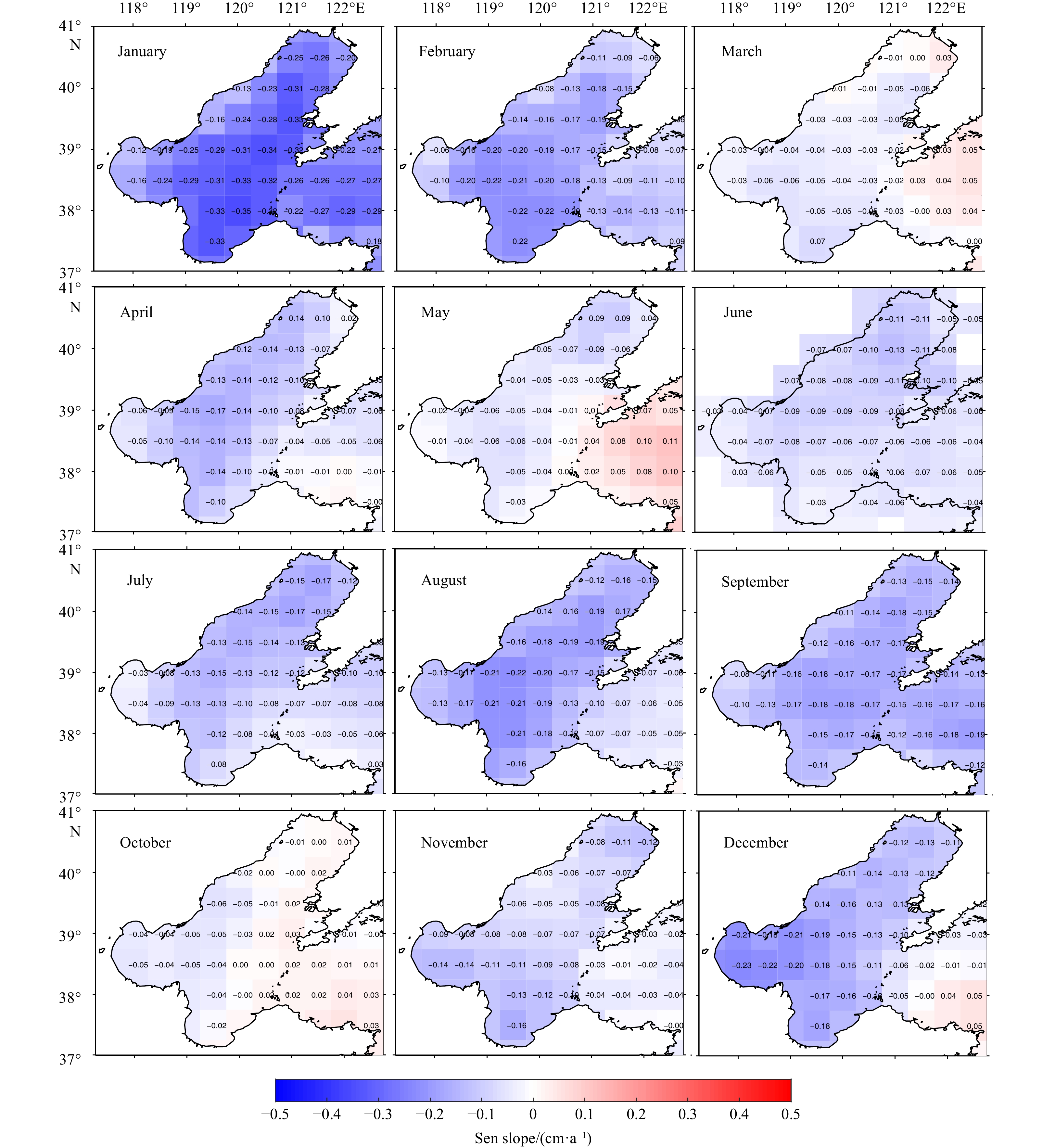
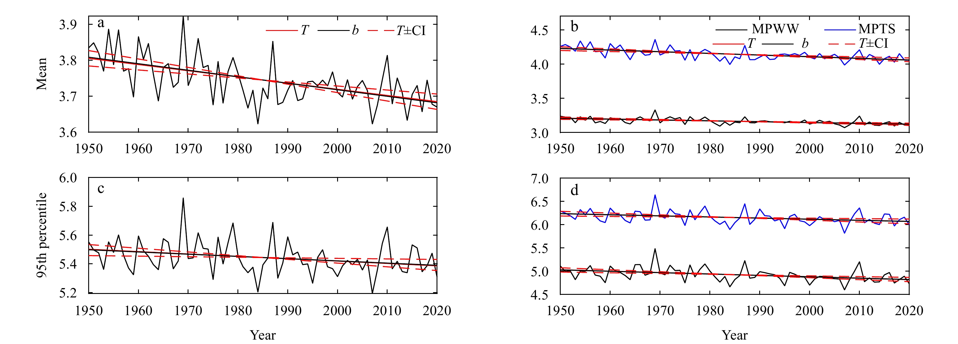
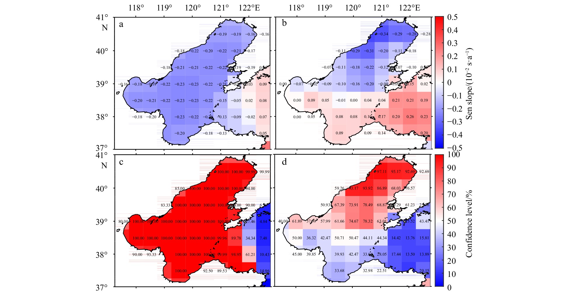
Reasonably understanding of the long-term wave characteristics is very crucial for the ocean engineering. A feedforward neural network is operated for interpolating ERA5 wave reanalysis in this study, which embodies a detailed record from 1950 onwards. The spatiotemporal variability of wave parameters in the Bohai Sea, especially the significant wave height (SWH), is presented in terms of combined wave, wind wave and swell by employing the 71 years (1950–2020) of interpolated ERA5 reanalysis. Annual mean SWH decreases at −0.12 cm/a estimated by Theil-Sen estimator and 95th percentile SWH reflecting serve sea states decreases at −0.20 cm/a. Inter-seasonal analysis shows SWH of wind wave has steeper decreasing trend with higher slopes than that of swell, especially in summer and winter, showing the major decrease may attribute to the weakening of monsoon. The inner Bohai Sea reveals a general decreasing trend while the intersection connecting with the Yellow Sea has the lower significance derived by Mann-Kendall test. Meanwhile, 95th percentile SWH decreases at a higher rate while with a lower significance in comparison with the mean state. The frequencies of mean wave directions in sub-sector are statistically calculated to find the seasonal prevailing directions. Generally, the dominant directions in summer and winter are south and north. A similar variation concerning to SWH, the trend of the mean wave period is provided, which also shows a decrease for decades.
Reasonably understanding of the long-term wave characteristics is very crucial for the ocean engineering. A feedforward neural network is operated for interpolating ERA5 wave reanalysis in this study, which embodies a detailed record from 1950 onwards. The spatiotemporal variability of wave parameters in the Bohai Sea, especially the significant wave height (SWH), is presented in terms of combined wave, wind wave and swell by employing the 71 years (1950–2020) of interpolated ERA5 reanalysis. Annual mean SWH decreases at −0.12 cm/a estimated by Theil-Sen estimator and 95th percentile SWH reflecting serve sea states decreases at −0.20 cm/a. Inter-seasonal analysis shows SWH of wind wave has steeper decreasing trend with higher slopes than that of swell, especially in summer and winter, showing the major decrease may attribute to the weakening of monsoon. The inner Bohai Sea reveals a general decreasing trend while the intersection connecting with the Yellow Sea has the lower significance derived by Mann-Kendall test. Meanwhile, 95th percentile SWH decreases at a higher rate while with a lower significance in comparison with the mean state. The frequencies of mean wave directions in sub-sector are statistically calculated to find the seasonal prevailing directions. Generally, the dominant directions in summer and winter are south and north. A similar variation concerning to SWH, the trend of the mean wave period is provided, which also shows a decrease for decades.


2022, 41(7): 113-127.
doi: 10.1007/s13131-022-1990-8
Abstract:
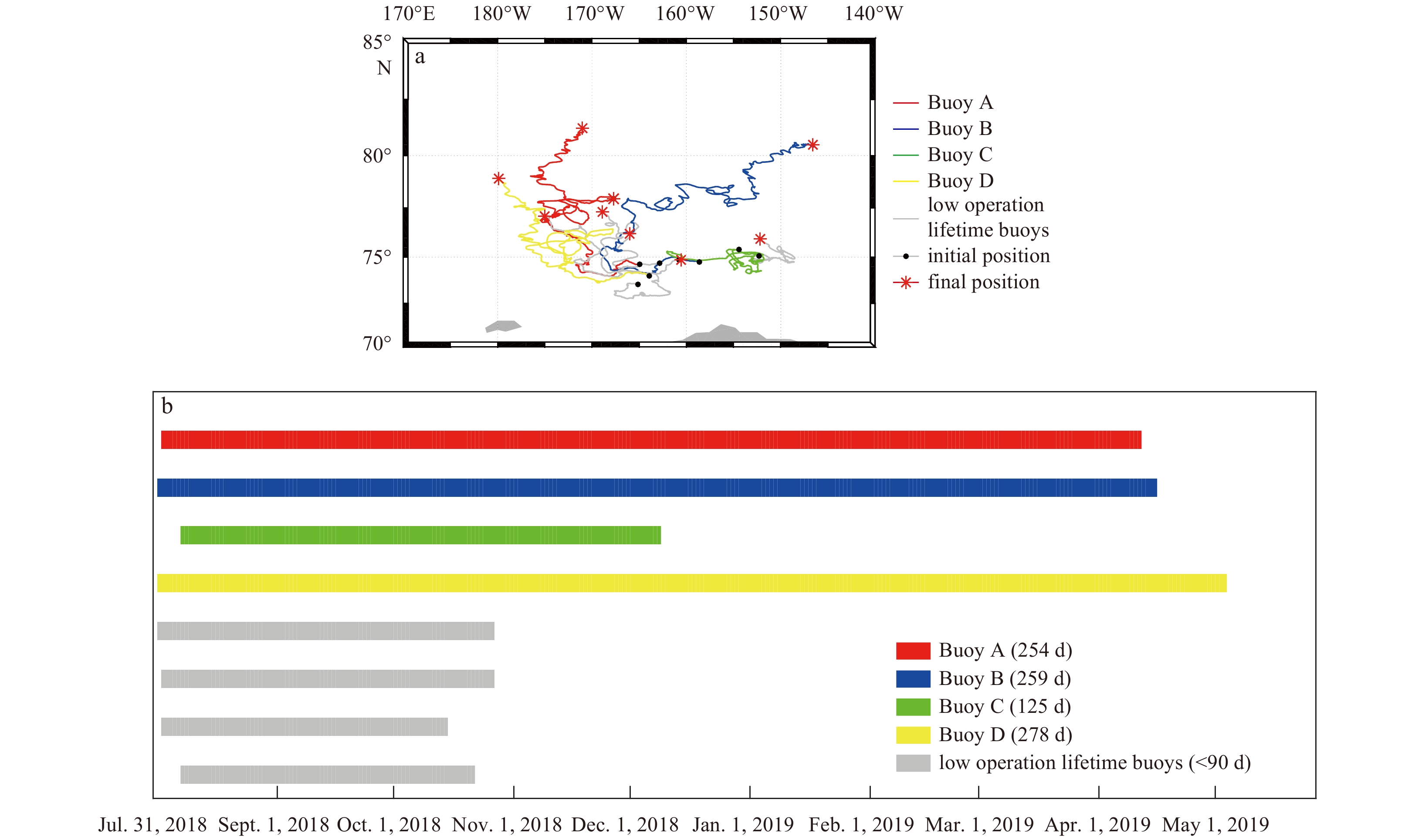
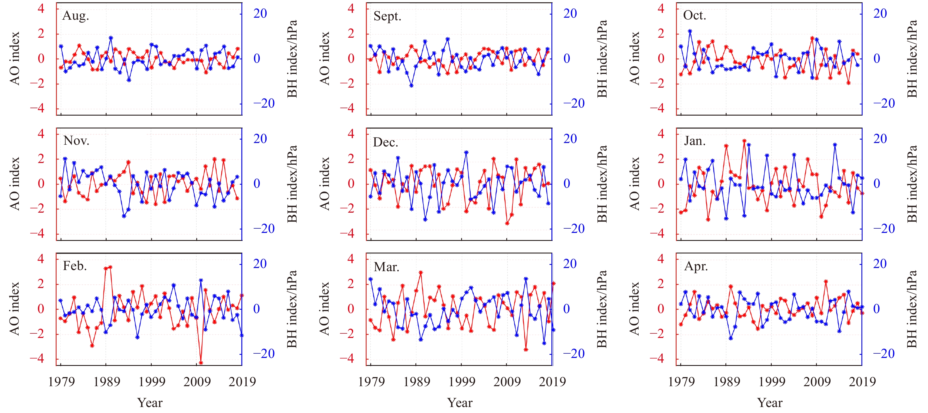
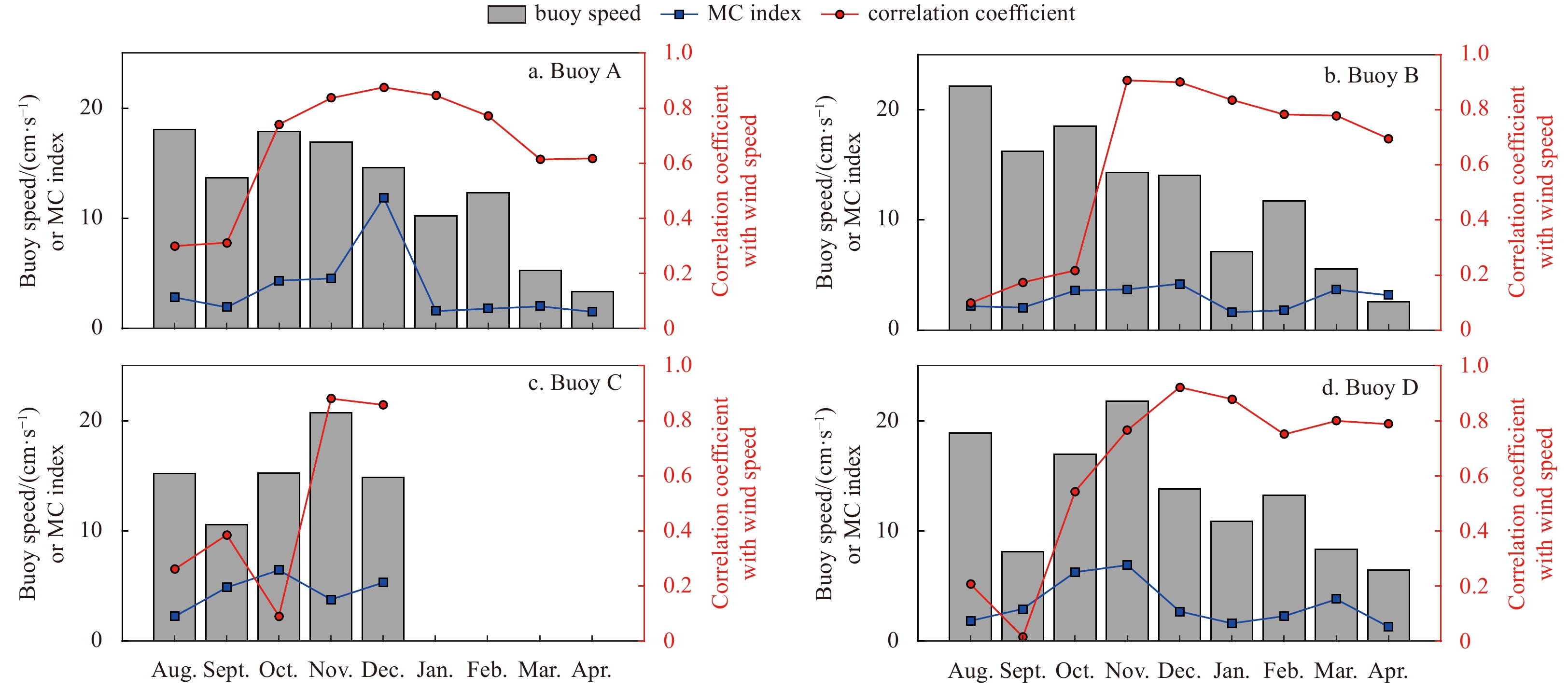
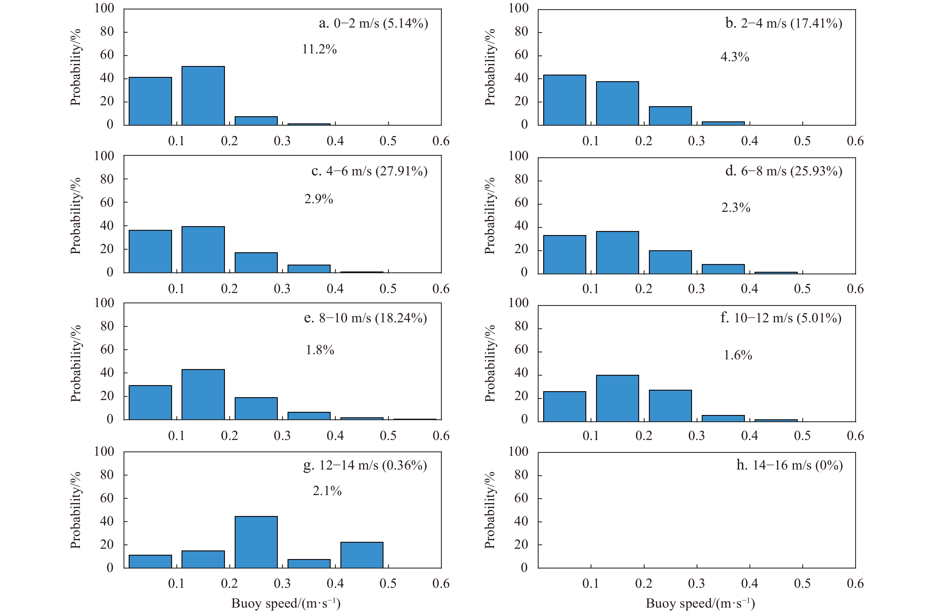
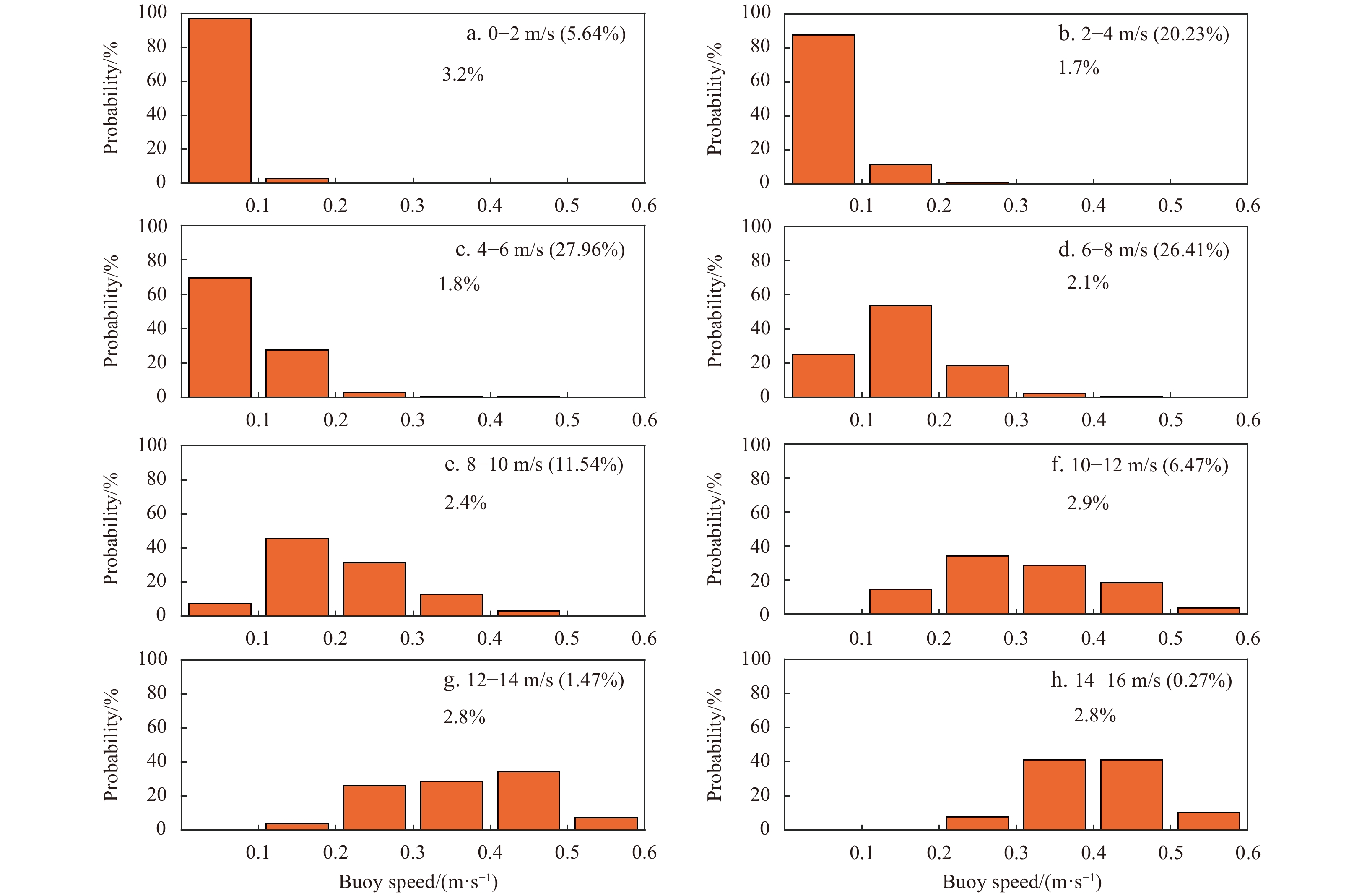
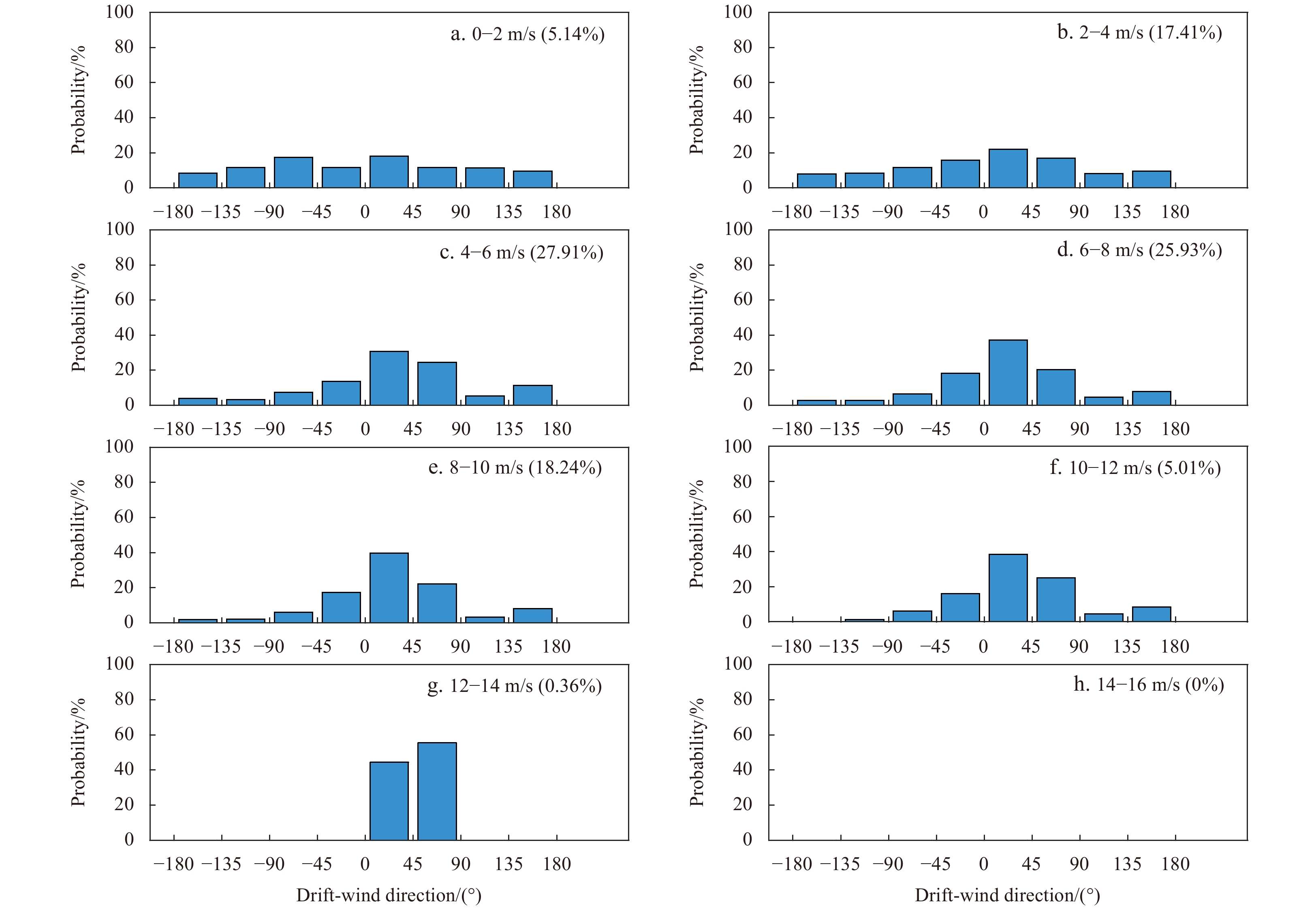
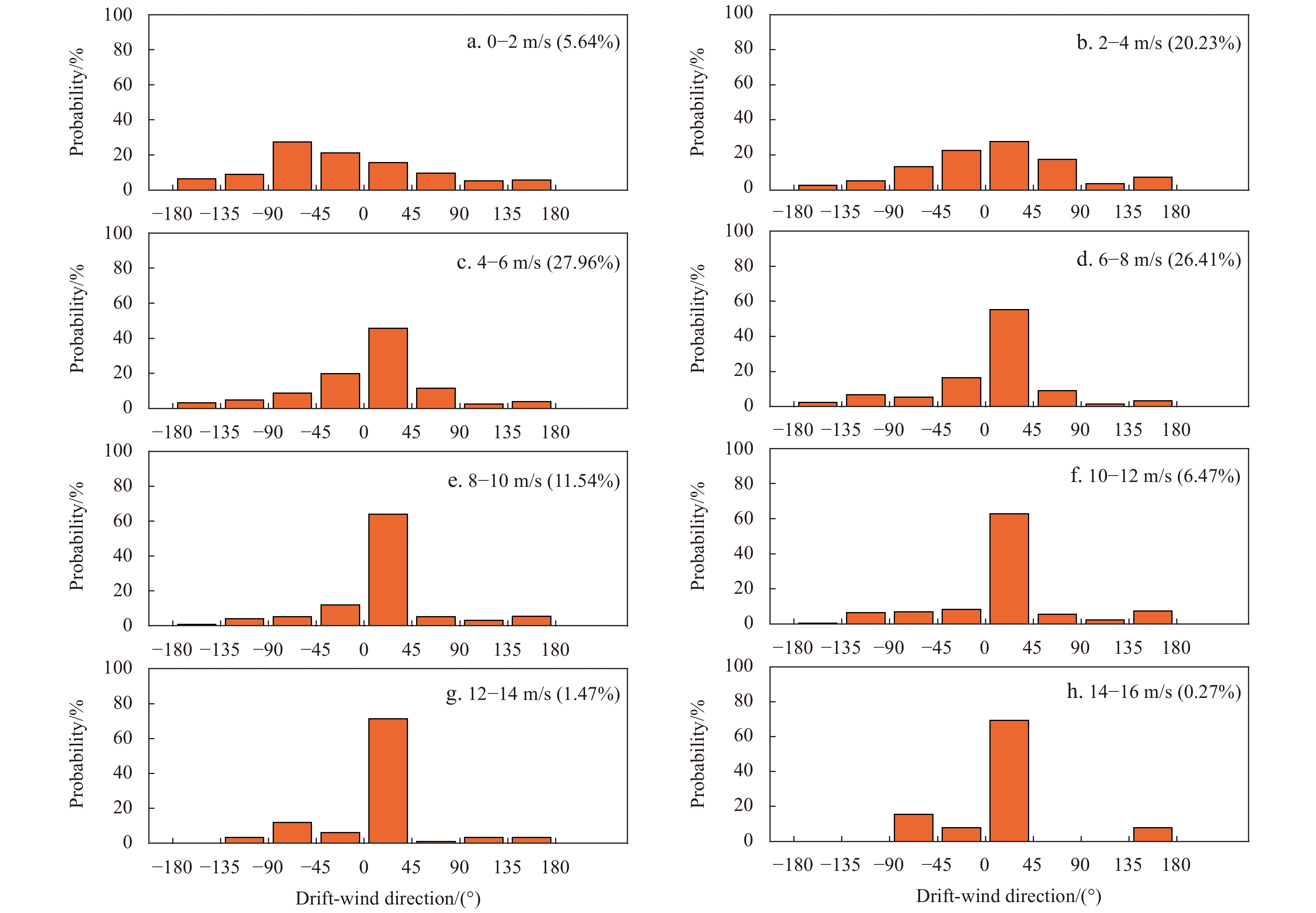
Sea ice growth and consolidation play a significant role in heat and momentum exchange between the atmosphere and the ocean. However, few in situ observations of sea ice kinematics have been reported owing to difficulties of deployment of buoys in the marginal ice zone (MIZ). To investigate the characteristics of sea ice kinematics from MIZ to packed ice zone (PIZ), eight drifting buoys designed by Taiyuan University of Technology were deployed in the open water at the ice edge of the Canadian Basin. Sea ice near the buoy constantly increased as the buoy drifted, and the kinematics of the buoy changed as the buoy was frozen into the ice. This process can be determined using sea ice concentration, sea skin temperature, and drift speed of buoy together. Sea ice concentration data showed that buoys entered the PIZ in mid-October as the ice grew and consolidated around the buoys, with high amplitude, high frequency buoy motions almost ceasing. Our results confirmed that good correlation coefficient in monthly scale between buoy drift and the wind only happened in the ice zone. The correlation coefficient between buoys and wind was below 0.3 while the buoys were in open water. As buoys entered the ice zone, the buoy speed was normally distributed at wind speeds above 6 m/s. The buoy drifted mainly to the right of the wind within 45° at wind speeds above 8 m/s. During further consolidation of the ice in MIZ, the direct forcing on the ice through winds will be lessened. The correlation coefficient value increased to 0.9 in November, and gradually decreased to 0.7 in April.
Sea ice growth and consolidation play a significant role in heat and momentum exchange between the atmosphere and the ocean. However, few in situ observations of sea ice kinematics have been reported owing to difficulties of deployment of buoys in the marginal ice zone (MIZ). To investigate the characteristics of sea ice kinematics from MIZ to packed ice zone (PIZ), eight drifting buoys designed by Taiyuan University of Technology were deployed in the open water at the ice edge of the Canadian Basin. Sea ice near the buoy constantly increased as the buoy drifted, and the kinematics of the buoy changed as the buoy was frozen into the ice. This process can be determined using sea ice concentration, sea skin temperature, and drift speed of buoy together. Sea ice concentration data showed that buoys entered the PIZ in mid-October as the ice grew and consolidated around the buoys, with high amplitude, high frequency buoy motions almost ceasing. Our results confirmed that good correlation coefficient in monthly scale between buoy drift and the wind only happened in the ice zone. The correlation coefficient between buoys and wind was below 0.3 while the buoys were in open water. As buoys entered the ice zone, the buoy speed was normally distributed at wind speeds above 6 m/s. The buoy drifted mainly to the right of the wind within 45° at wind speeds above 8 m/s. During further consolidation of the ice in MIZ, the direct forcing on the ice through winds will be lessened. The correlation coefficient value increased to 0.9 in November, and gradually decreased to 0.7 in April.


2022, 41(7): 128-138.
doi: 10.1007/s13131-021-1981-1
Abstract:
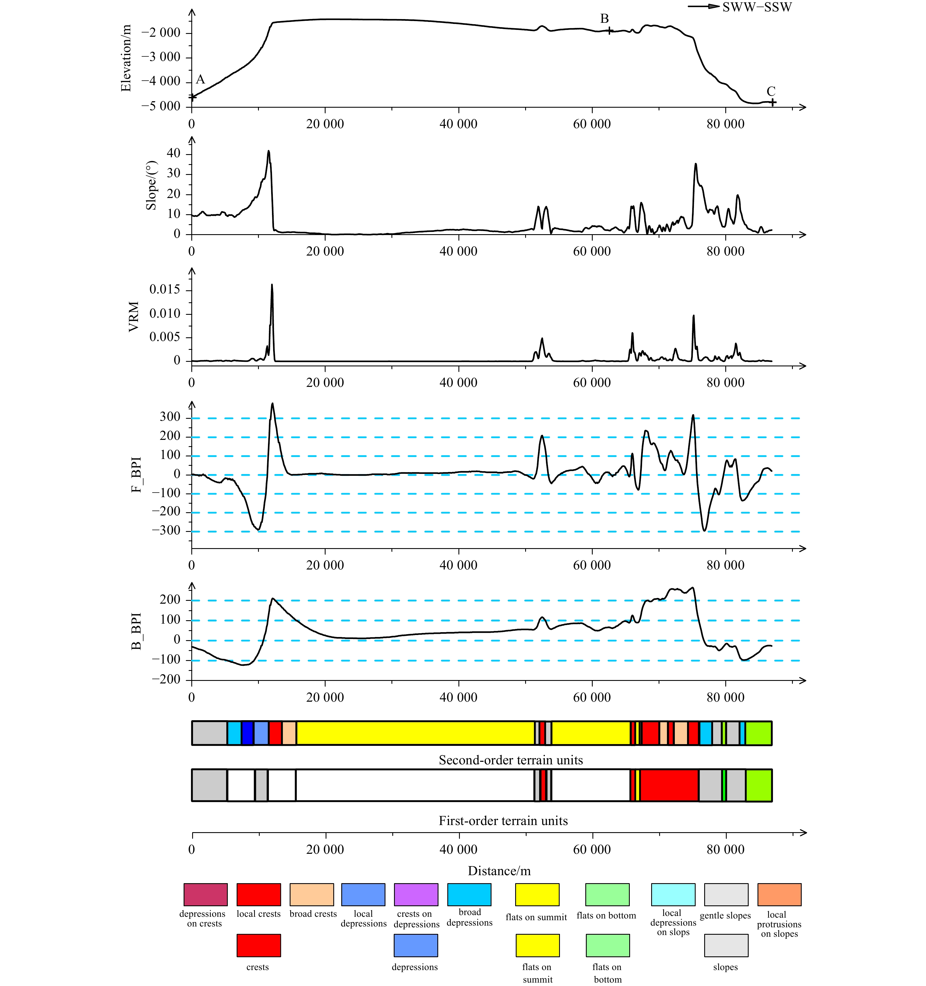
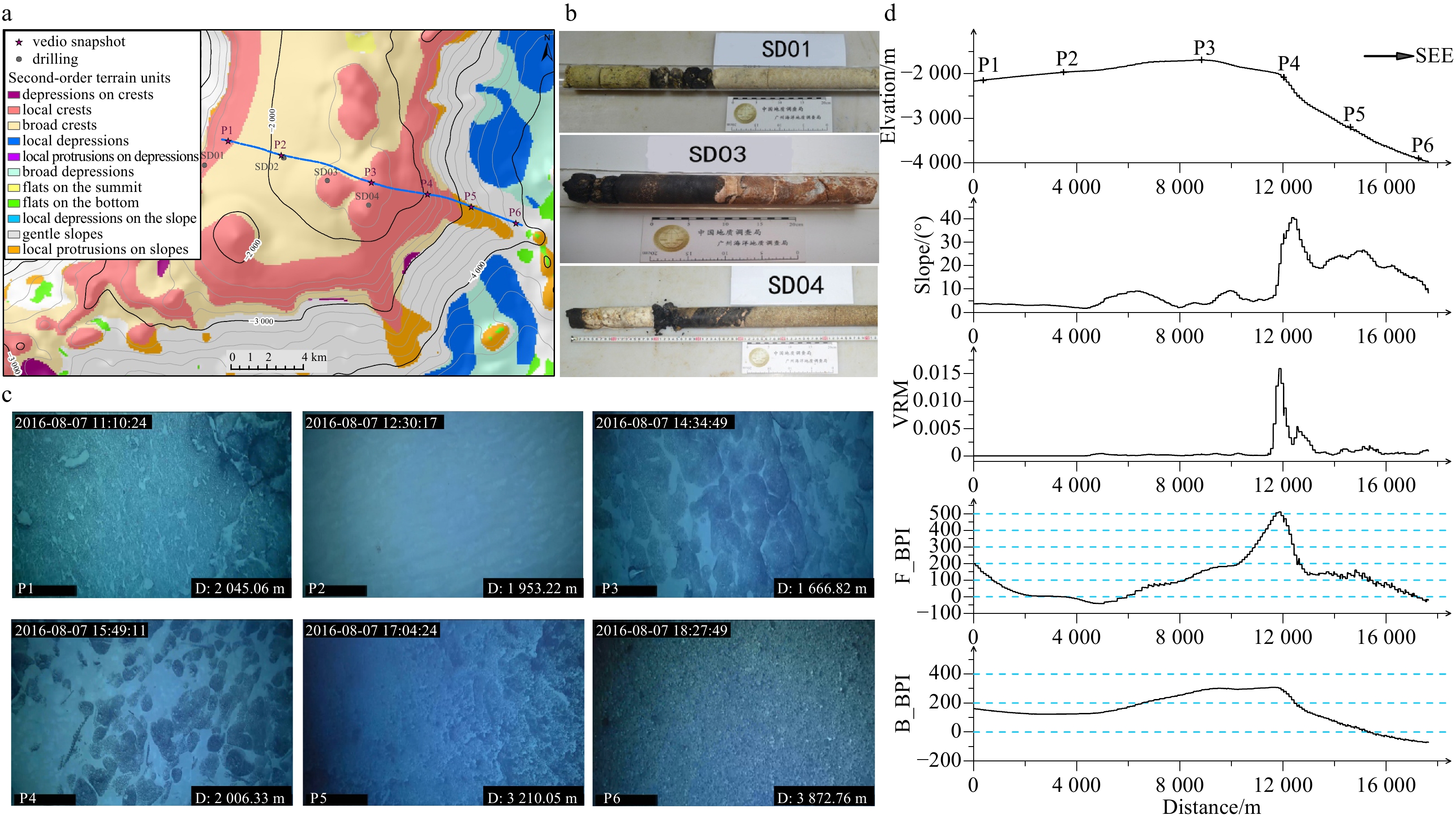
Given the advances in satellite altimetry and multibeam bathymetry, benthic terrain classification based on digital bathymetric models (DBMs) has been widely used for the mapping of benthic topographies. For instance, cobalt-rich crusts (CRCs) are important mineral resources found on seamounts and guyots in the western Pacific Ocean. Thick, plate-like CRCs are known to form on the summit and slopes of seamounts at the 1 000–3 000 m depth, while the relationship between seamount topography and spatial distribution of CRCs remains unclear. The benthic terrain classification of seamounts can solve this problem, thereby, facilitating the rapid exploration of seamount CRCs. Our study used an EM122 multibeam echosounder to retrieve high-resolution bathymetry data in the CRCs contract license area of China, i.e., the Jiaxie Guyots in 2015 and 2016. Based on the DBM construted by bathymetirc data, broad- and fine-scale bathymetric position indices were utilized for quantitative classification of the terrain units of the Jiaxie Guyots on multiple scales. The classification revealed four first-order terrain units (e.g., flat, crest, slope, and depression) and eleven second-order terrain units (e.g., local crests, depressions on crests, gentle slopes, crests on slopes, and local depressions, etc.). Furthermore, the classification of the terrain and geological analysis indicated that the Weijia Guyot has a large flat summit, with local crests at the southern summit, whereas most of the guyot flanks were covered by gentle slopes. “Radial” mountain ridges have developed on the eastern side, while large-scale gravitational landslides have developed on the western and southern flanks. Additionally, landslide masses can be observed at the bottom of these slopes. The coverage of local crests on the seamount is ~1 000 km2, and the local crests on the peak and flanks of the guyots may be the areas where thick and continuous plate-like CRCs are likely to occur.
Given the advances in satellite altimetry and multibeam bathymetry, benthic terrain classification based on digital bathymetric models (DBMs) has been widely used for the mapping of benthic topographies. For instance, cobalt-rich crusts (CRCs) are important mineral resources found on seamounts and guyots in the western Pacific Ocean. Thick, plate-like CRCs are known to form on the summit and slopes of seamounts at the 1 000–3 000 m depth, while the relationship between seamount topography and spatial distribution of CRCs remains unclear. The benthic terrain classification of seamounts can solve this problem, thereby, facilitating the rapid exploration of seamount CRCs. Our study used an EM122 multibeam echosounder to retrieve high-resolution bathymetry data in the CRCs contract license area of China, i.e., the Jiaxie Guyots in 2015 and 2016. Based on the DBM construted by bathymetirc data, broad- and fine-scale bathymetric position indices were utilized for quantitative classification of the terrain units of the Jiaxie Guyots on multiple scales. The classification revealed four first-order terrain units (e.g., flat, crest, slope, and depression) and eleven second-order terrain units (e.g., local crests, depressions on crests, gentle slopes, crests on slopes, and local depressions, etc.). Furthermore, the classification of the terrain and geological analysis indicated that the Weijia Guyot has a large flat summit, with local crests at the southern summit, whereas most of the guyot flanks were covered by gentle slopes. “Radial” mountain ridges have developed on the eastern side, while large-scale gravitational landslides have developed on the western and southern flanks. Additionally, landslide masses can be observed at the bottom of these slopes. The coverage of local crests on the seamount is ~1 000 km2, and the local crests on the peak and flanks of the guyots may be the areas where thick and continuous plate-like CRCs are likely to occur.


2022, 41(7): 139-152.
doi: 10.1007/s13131-021-1973-1
Abstract:
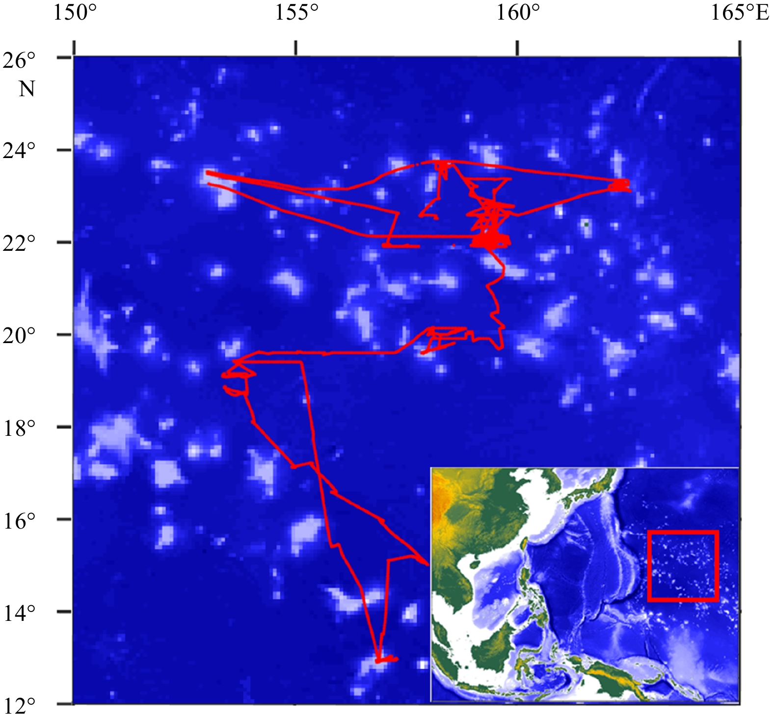
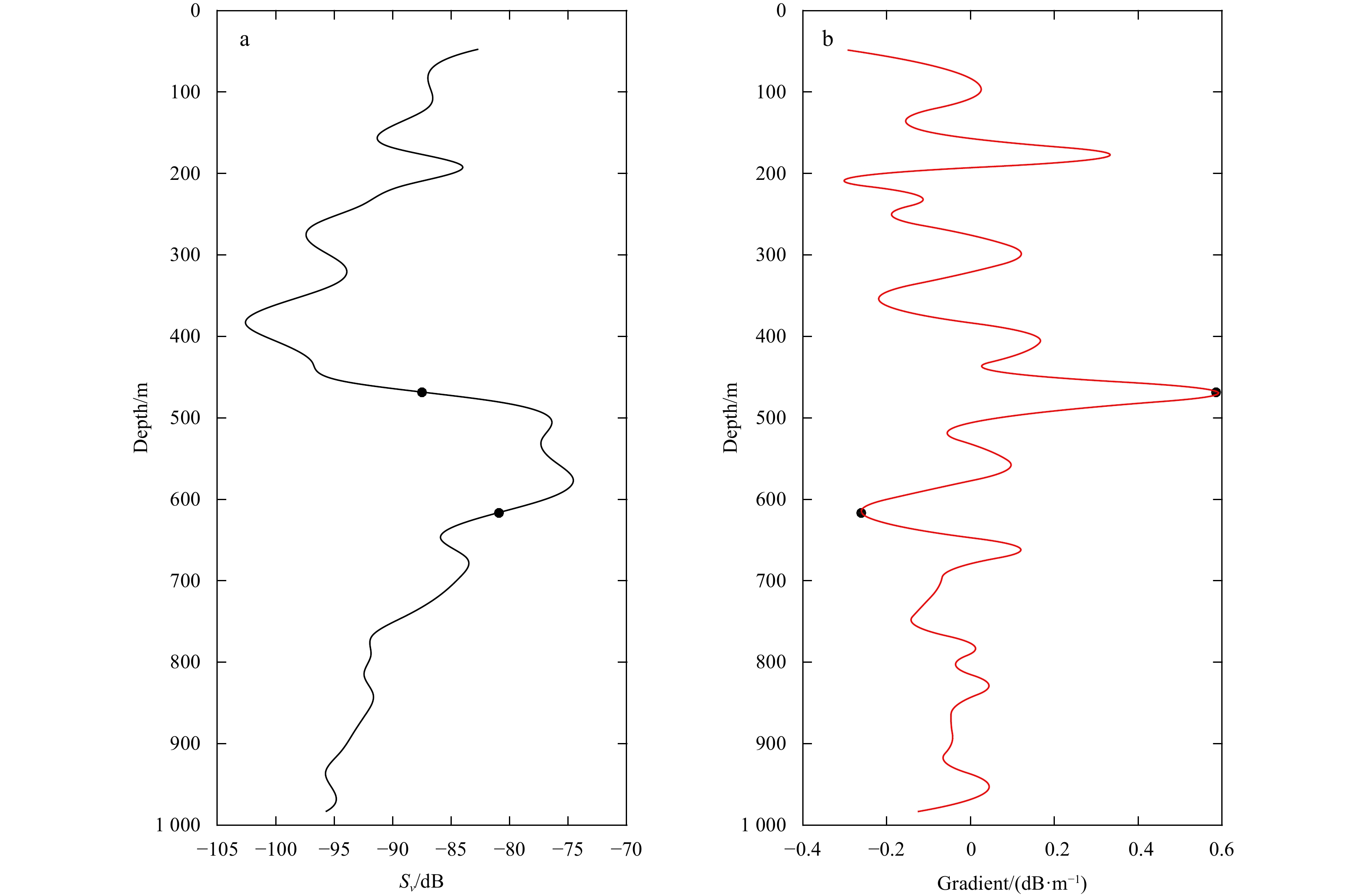
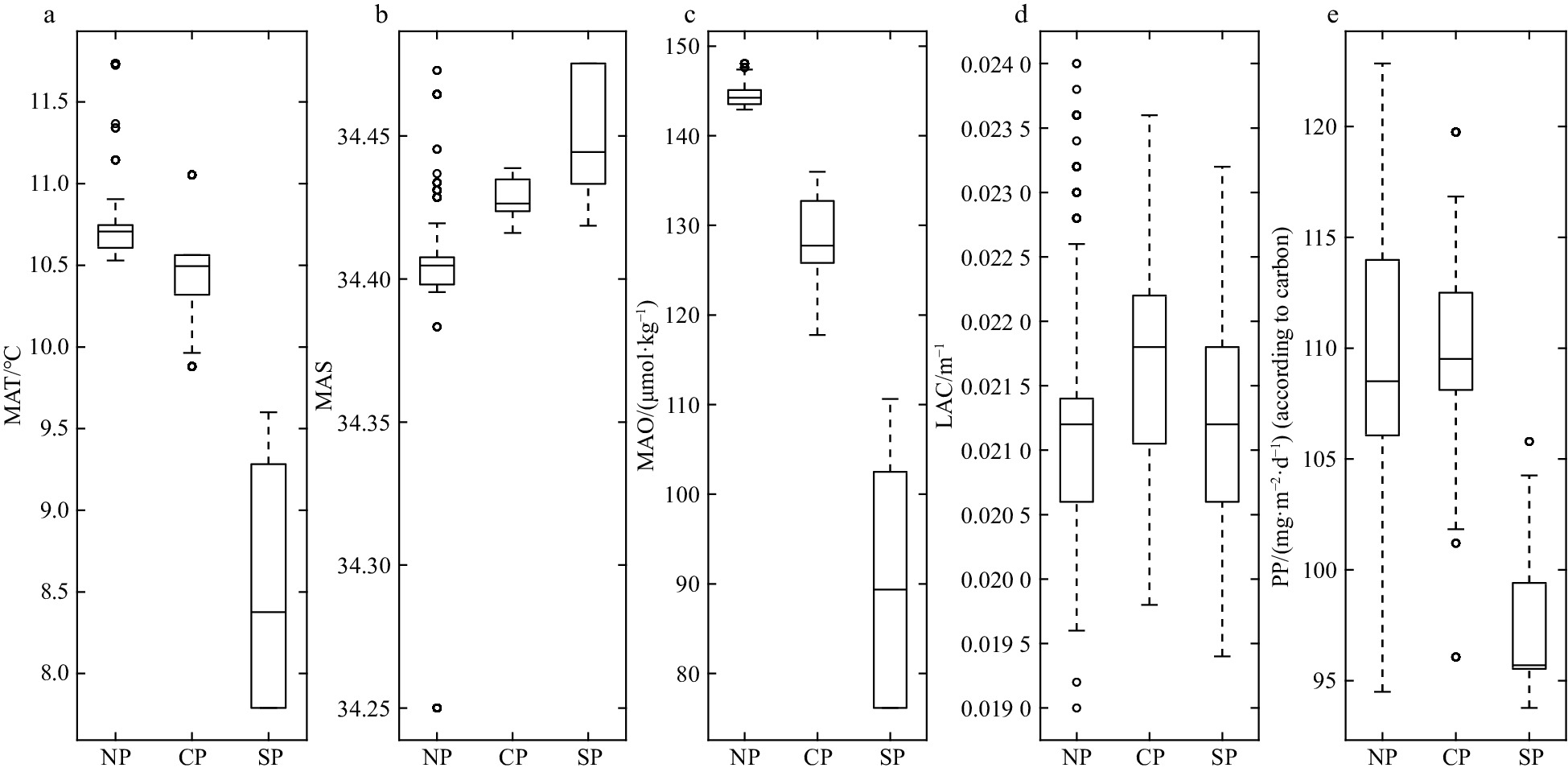
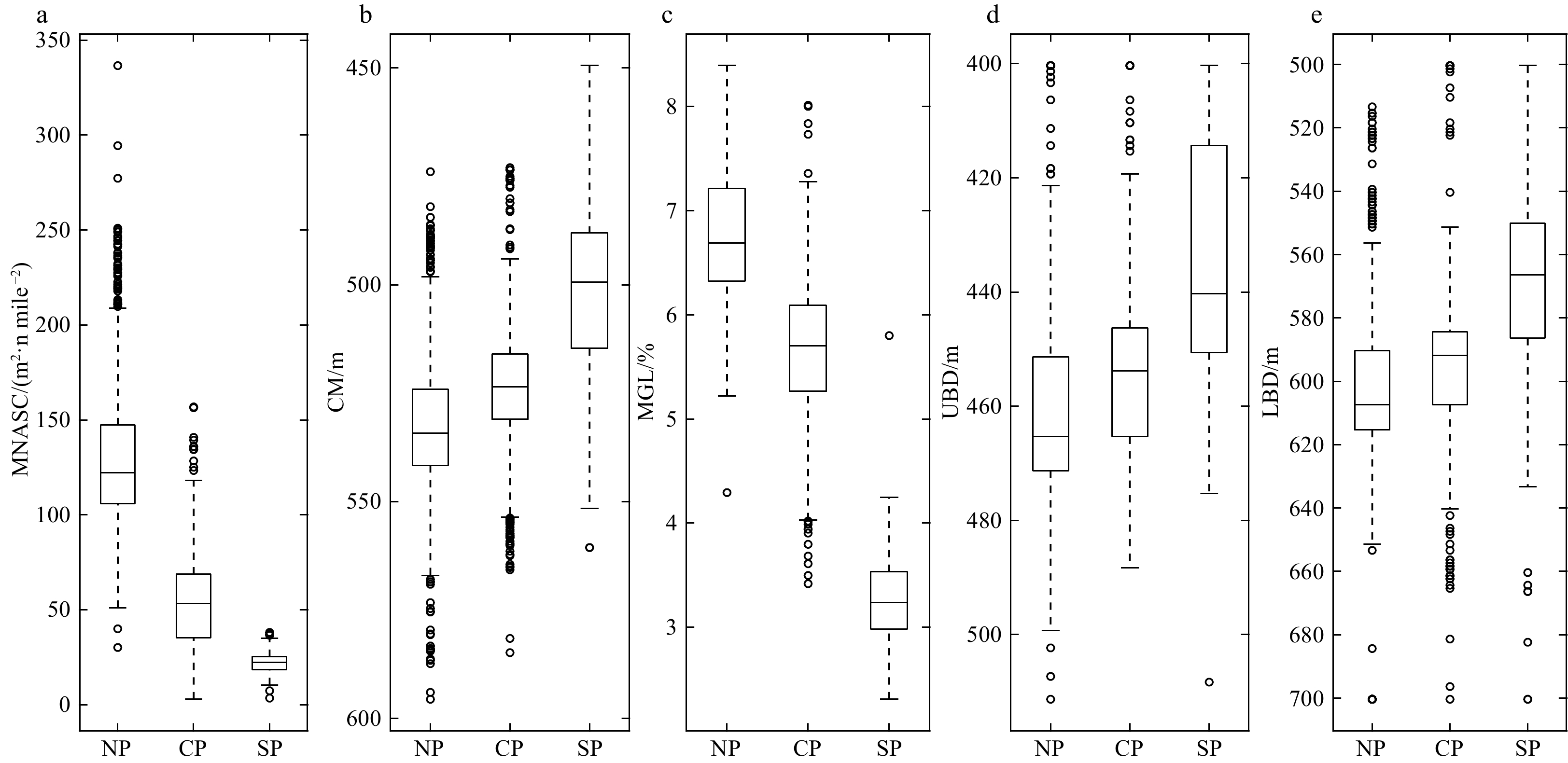
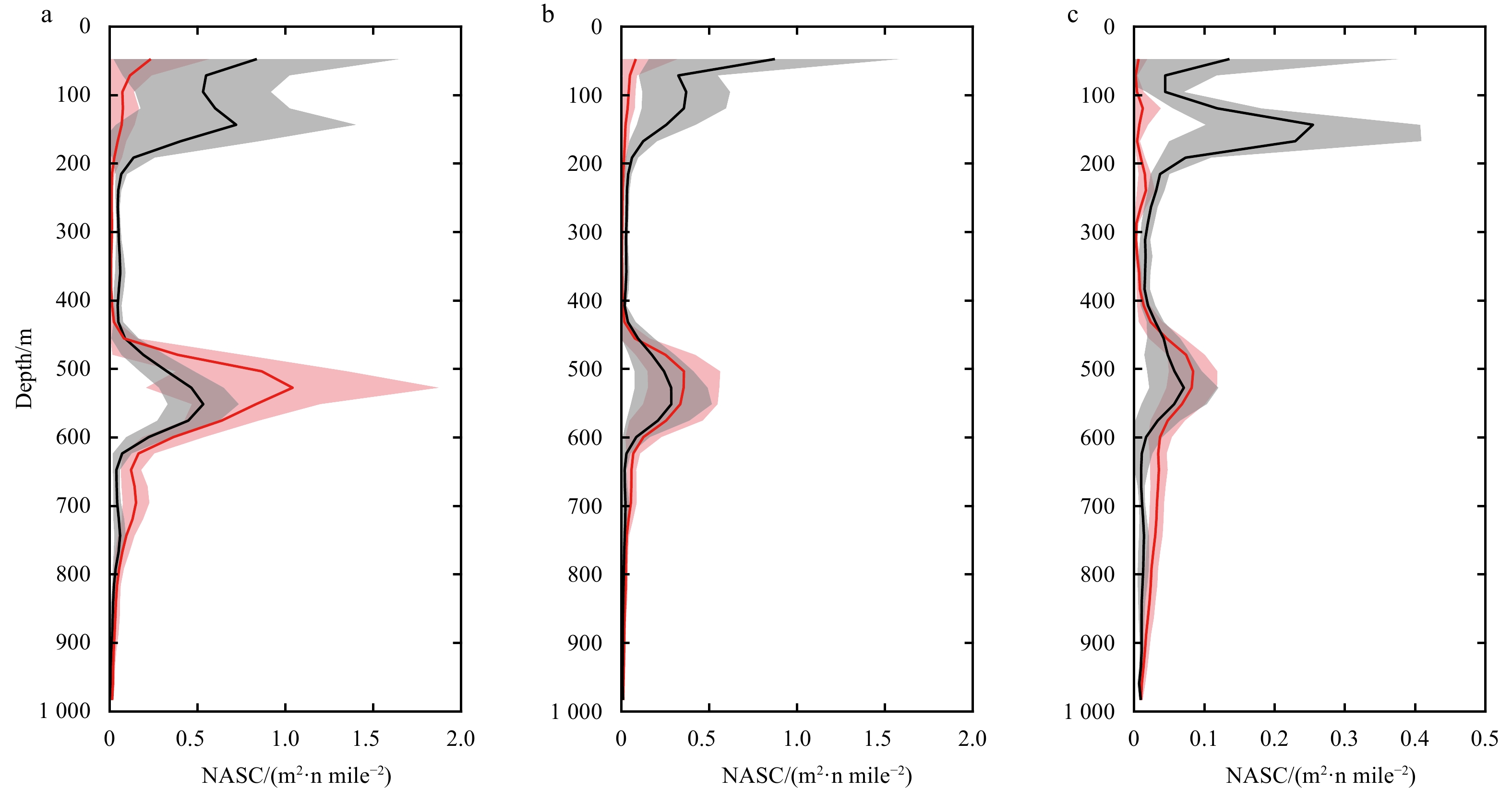
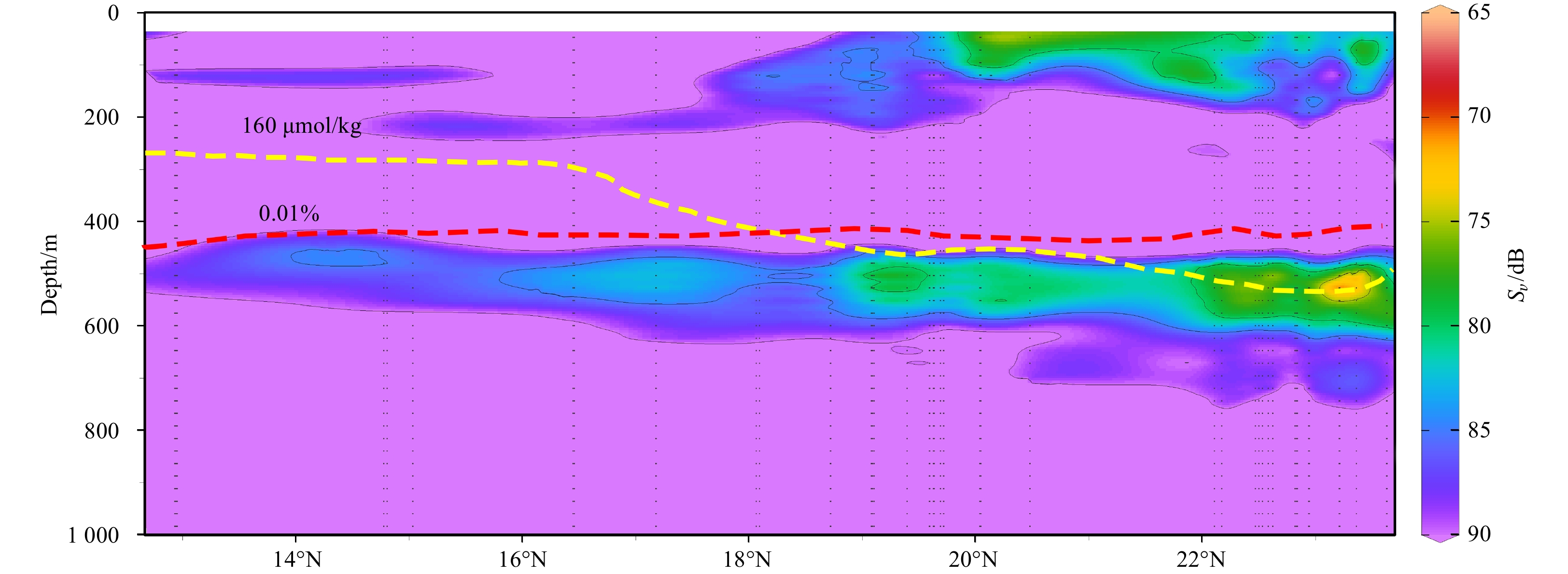
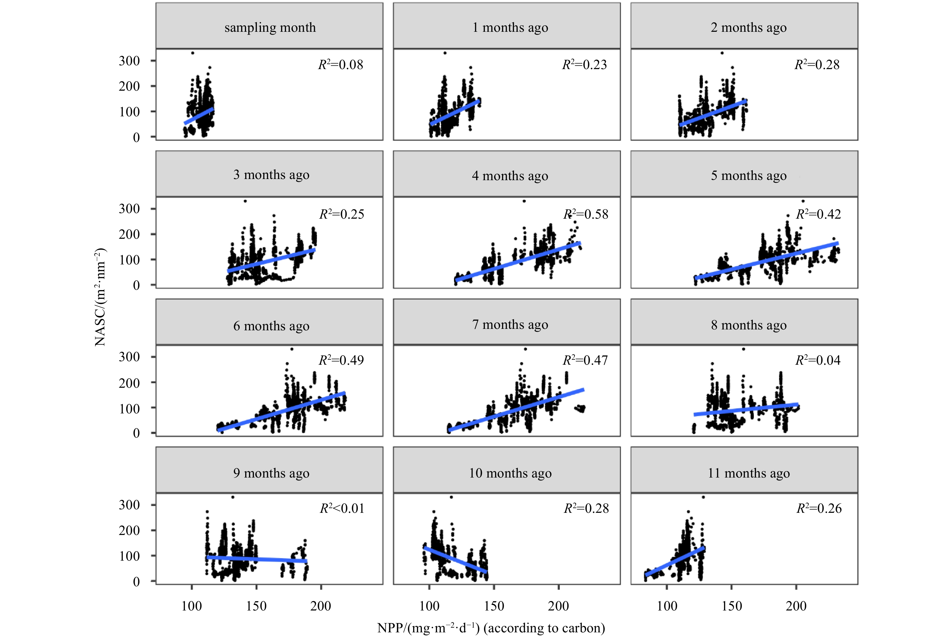
The mesopelagic communities are important for food web and carbon pump in ocean, but the large-scale studies of them are still limited until now because of the difficulties on sampling and analyzing of mesopelagic organisms. Mesopelagic organisms, especially micronekton, can form acoustic deep scattering layers (DSLs) and DSLs are widely observed. To explore the spatial patterns of DSLs and their possible influencing factors, the DSLs during daytime (10:00–14:00) were investigated in the subtropical northwestern Pacific Ocean (13°–23.5°N, 153°–163°E) using a shipboard acoustic Doppler current profiler at 38 kHz. The study area was divided into three parts using k-means cluster analysis: the northern part (NP, 22°–24°N), the central part (CP, 17°–22°N), and the southern part (SP, 12°–17°N). The characteristics of DSLs varied widely with latitudinal gradient. Deepest core DSLs (523.5 m±17.4 m), largest nautical area scattering coefficient (NASC) (130.8 m2/n mile2±41.0 m2/n mile2), and most concentrated DSLs (mesopelagic organisms gathering level, 6.7%±0.7%) were observed in NP. The proportion of migration was also stronger in NP (39.7%) than those in other parts (18.6% in CP and 21.5% in SP) for mesopelagic organisms. The latitudinal variation of DSLs was probably caused by changes in oxygen concentration and light intensity of mesopelagic zones. A positive relationship between NASC and primary productivity was identified. A four-months lag was seemed to exist. This study provides the first basin-scale baselines information of mesopelagic communities in the northwest Pacific with acoustic approach. Further researches are suggested to gain understandings of seasonal and annual variations of DSLs in the region.
The mesopelagic communities are important for food web and carbon pump in ocean, but the large-scale studies of them are still limited until now because of the difficulties on sampling and analyzing of mesopelagic organisms. Mesopelagic organisms, especially micronekton, can form acoustic deep scattering layers (DSLs) and DSLs are widely observed. To explore the spatial patterns of DSLs and their possible influencing factors, the DSLs during daytime (10:00–14:00) were investigated in the subtropical northwestern Pacific Ocean (13°–23.5°N, 153°–163°E) using a shipboard acoustic Doppler current profiler at 38 kHz. The study area was divided into three parts using k-means cluster analysis: the northern part (NP, 22°–24°N), the central part (CP, 17°–22°N), and the southern part (SP, 12°–17°N). The characteristics of DSLs varied widely with latitudinal gradient. Deepest core DSLs (523.5 m±17.4 m), largest nautical area scattering coefficient (NASC) (130.8 m2/n mile2±41.0 m2/n mile2), and most concentrated DSLs (mesopelagic organisms gathering level, 6.7%±0.7%) were observed in NP. The proportion of migration was also stronger in NP (39.7%) than those in other parts (18.6% in CP and 21.5% in SP) for mesopelagic organisms. The latitudinal variation of DSLs was probably caused by changes in oxygen concentration and light intensity of mesopelagic zones. A positive relationship between NASC and primary productivity was identified. A four-months lag was seemed to exist. This study provides the first basin-scale baselines information of mesopelagic communities in the northwest Pacific with acoustic approach. Further researches are suggested to gain understandings of seasonal and annual variations of DSLs in the region.


2022, 41(7): 153-165.
doi: 10.1007/s13131-022-1991-7
Abstract:
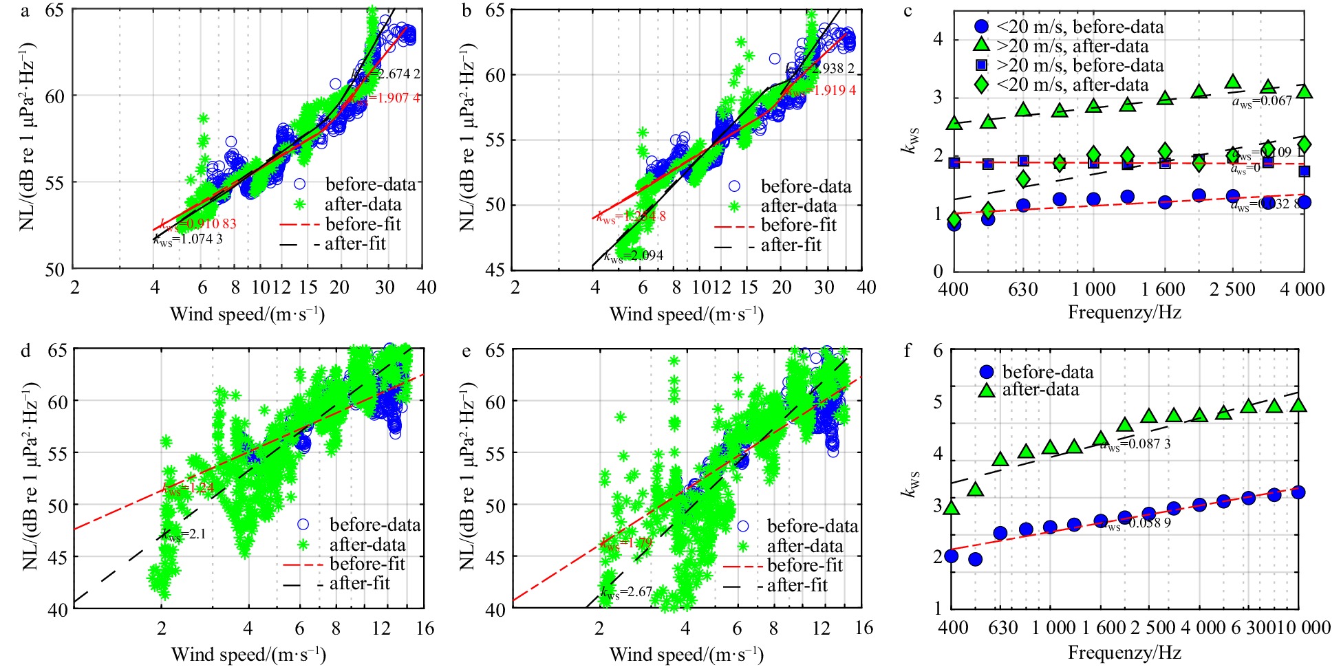
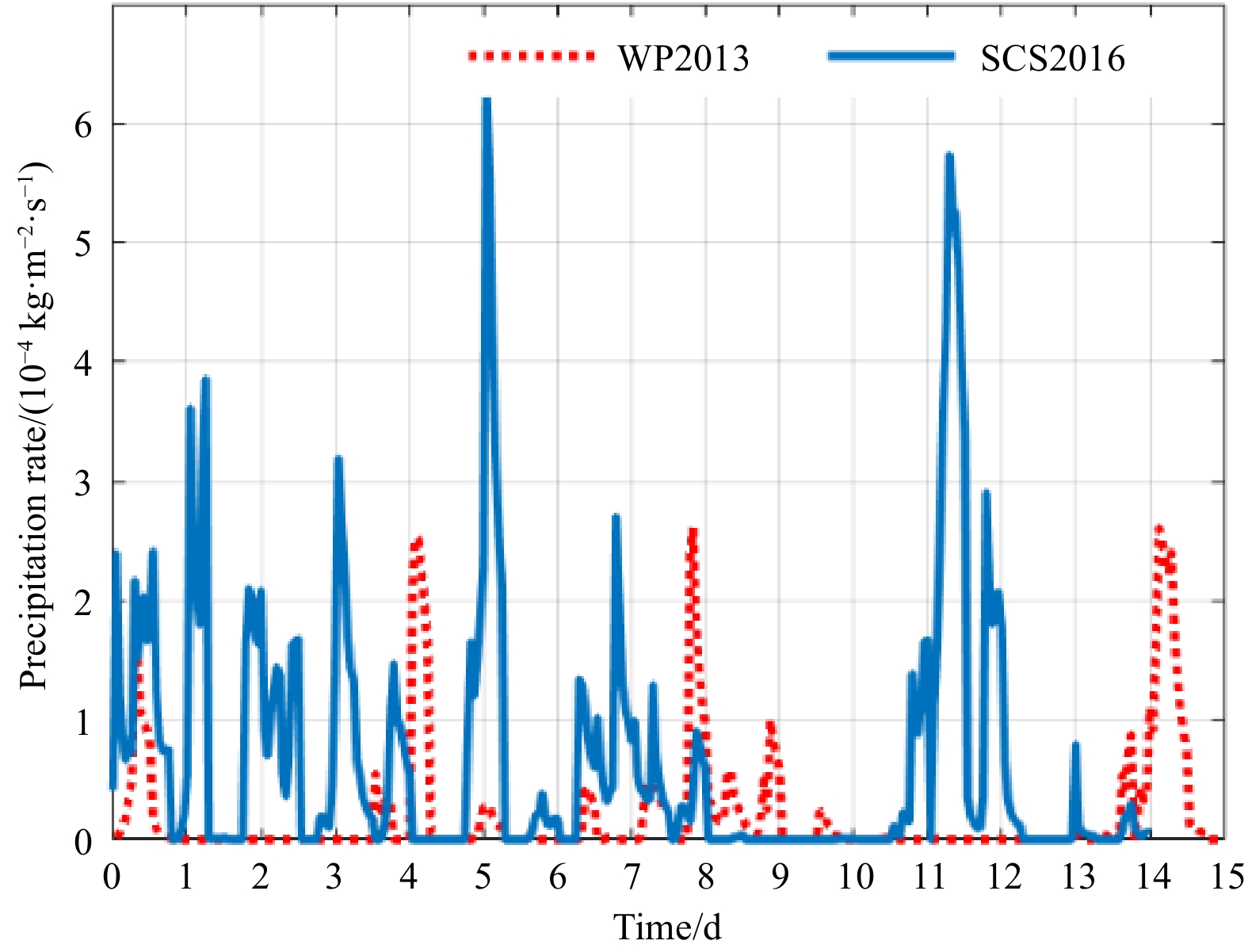
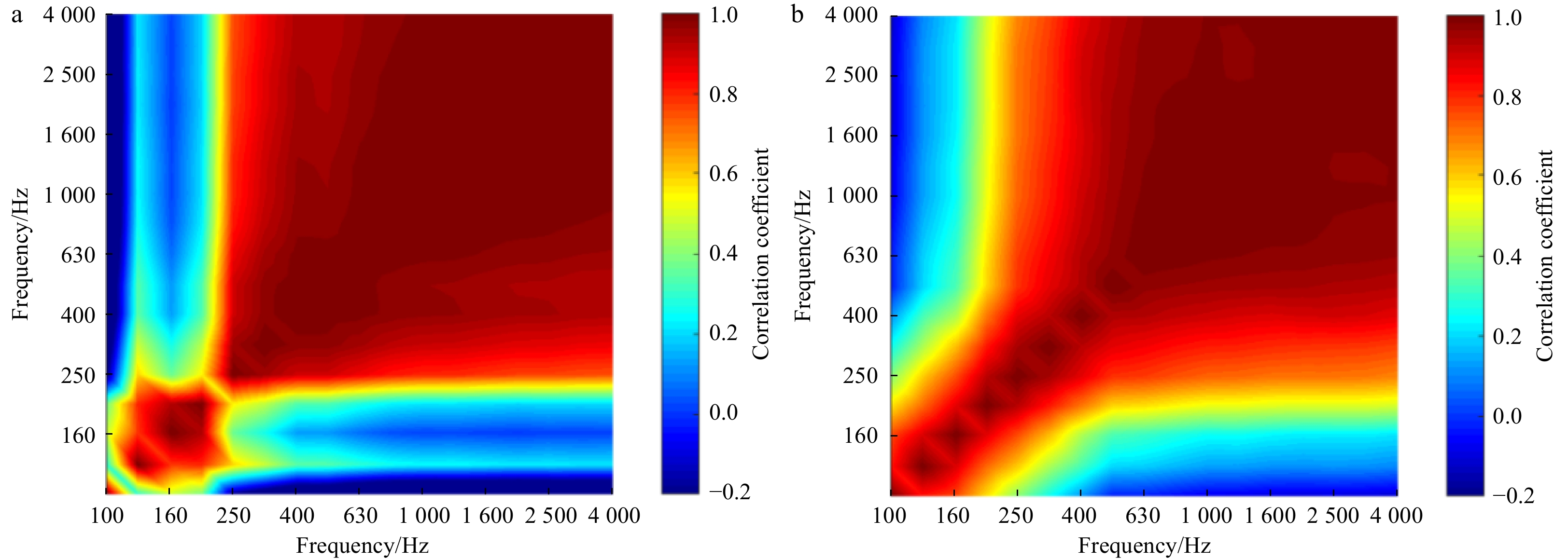
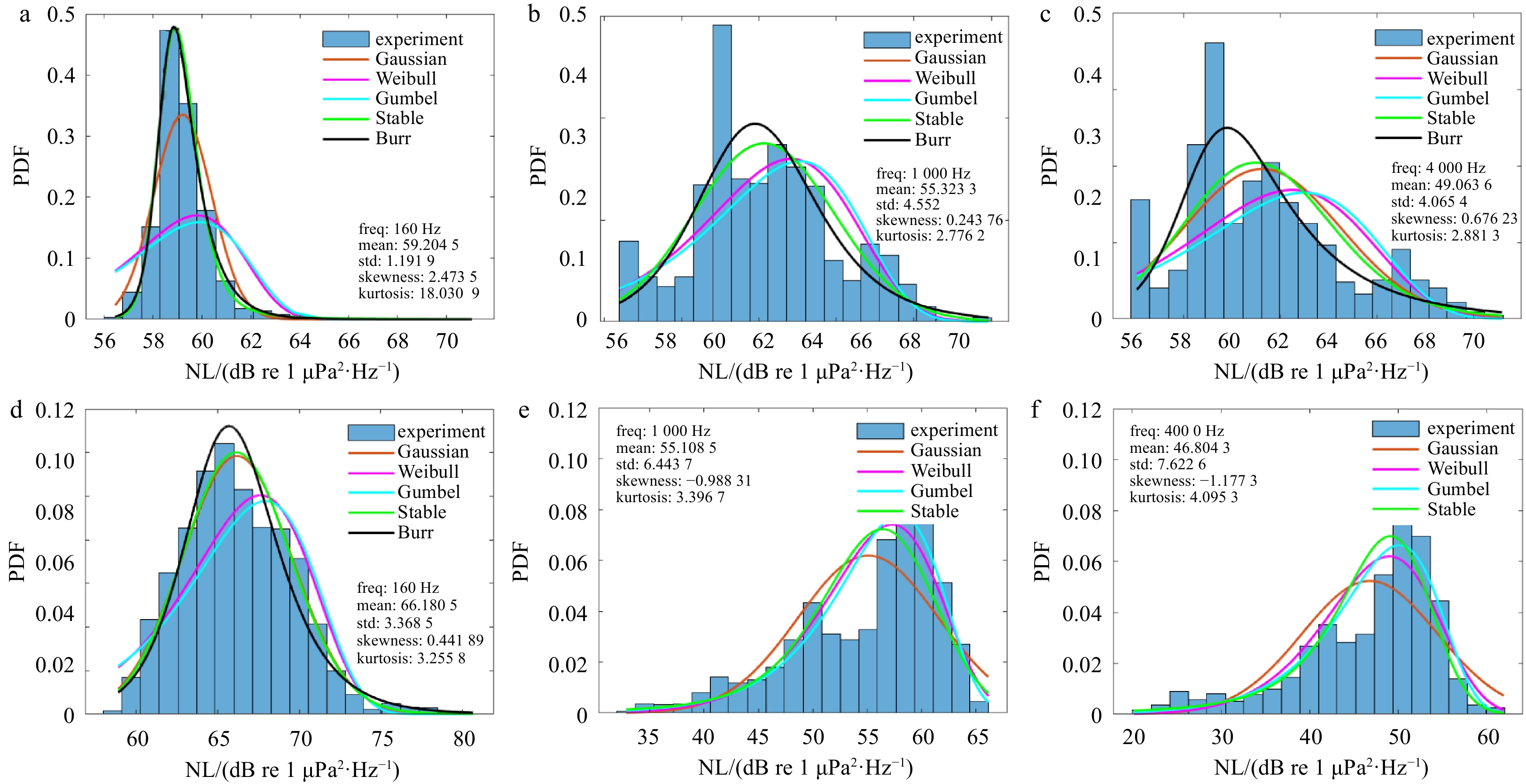
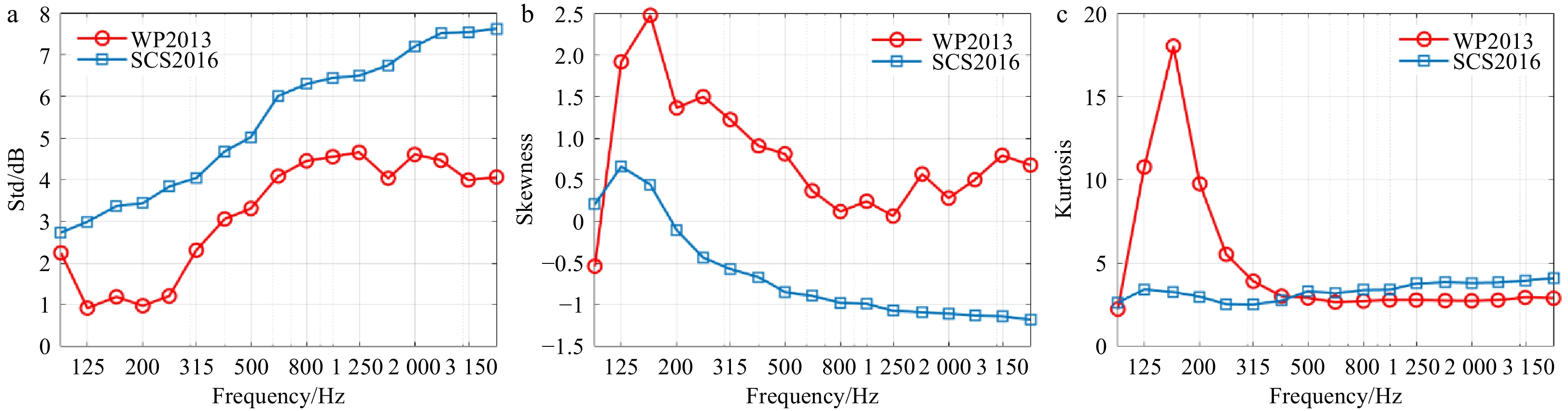
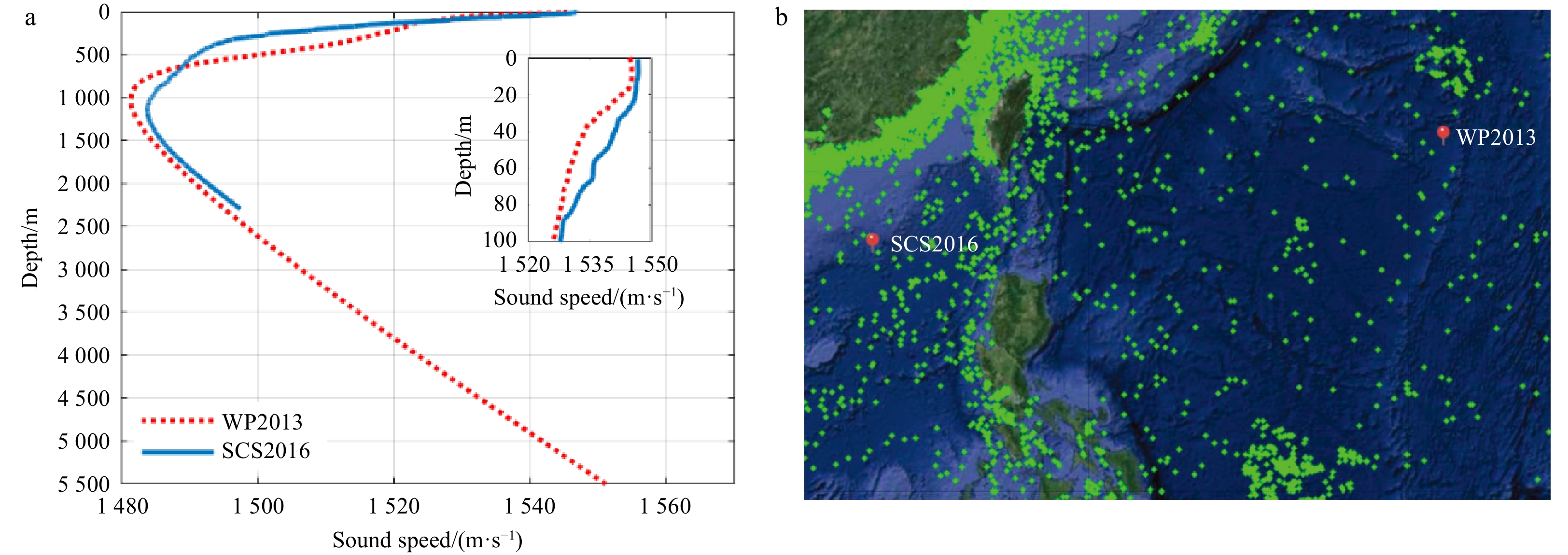
Oceanic noise is the background interference in sonar performance prediction and evaluation at high sea states. Statistics of underwater ambient noise during Typhoons Soulik and Nida were analyzed on the basis of experimental measurements conducted in a deep area of the Philippine Sea and the South China Sea. Generated linear regression, frequency correlation matrix (FCM), Burr distribution and Gumbel distribution were described for the analysis of correlation with environmental parameters including wind speed (WS), significant wave height (SWH), and the inter-frequency relationship and probability density function of noise levels (NLs). When the typhoons were quite close to the receivers, the increment of NLs exceeded 10 dB. Whilst ambient noise was completely dominated by wind agitation, NLs were proportional to the cubic and quintic functions of WS and SWH, respectively. The fitted results between NLs and oceanic parameters were different for “before typhoon” and “after typhoon”. The fitted slopes of linear regression showed a linear relationship with the logarithm of frequency. The average observed typhoon-generated NLs were 5 dB lower than the Wenz curve at the same wind force due to the insufficiently developed sea state or the delay between NLs and WS. The cross-correlation coefficient of FCM, which can be utilized in the identification of noise sources in different bands, exceeded 0.8 at frequencies higher than 250 Hz. Furthermore, standard deviation increased with frequency. The kurtosis was equal to 3 at >400 Hz approximately. The characteristics of NLs showed good agreement with the results of FCM.
Oceanic noise is the background interference in sonar performance prediction and evaluation at high sea states. Statistics of underwater ambient noise during Typhoons Soulik and Nida were analyzed on the basis of experimental measurements conducted in a deep area of the Philippine Sea and the South China Sea. Generated linear regression, frequency correlation matrix (FCM), Burr distribution and Gumbel distribution were described for the analysis of correlation with environmental parameters including wind speed (WS), significant wave height (SWH), and the inter-frequency relationship and probability density function of noise levels (NLs). When the typhoons were quite close to the receivers, the increment of NLs exceeded 10 dB. Whilst ambient noise was completely dominated by wind agitation, NLs were proportional to the cubic and quintic functions of WS and SWH, respectively. The fitted results between NLs and oceanic parameters were different for “before typhoon” and “after typhoon”. The fitted slopes of linear regression showed a linear relationship with the logarithm of frequency. The average observed typhoon-generated NLs were 5 dB lower than the Wenz curve at the same wind force due to the insufficiently developed sea state or the delay between NLs and WS. The cross-correlation coefficient of FCM, which can be utilized in the identification of noise sources in different bands, exceeded 0.8 at frequencies higher than 250 Hz. Furthermore, standard deviation increased with frequency. The kurtosis was equal to 3 at >400 Hz approximately. The characteristics of NLs showed good agreement with the results of FCM.


2022, 41(7): 166-179.
doi: 10.1007/s13131-021-1977-x
Abstract:
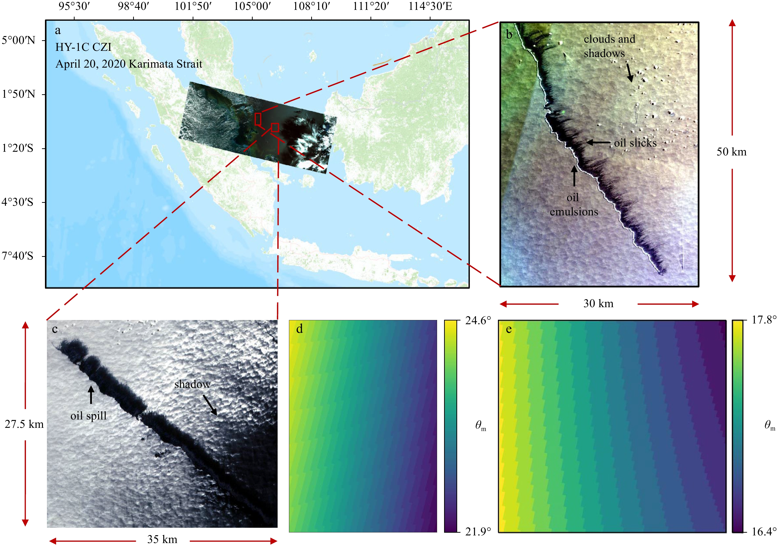
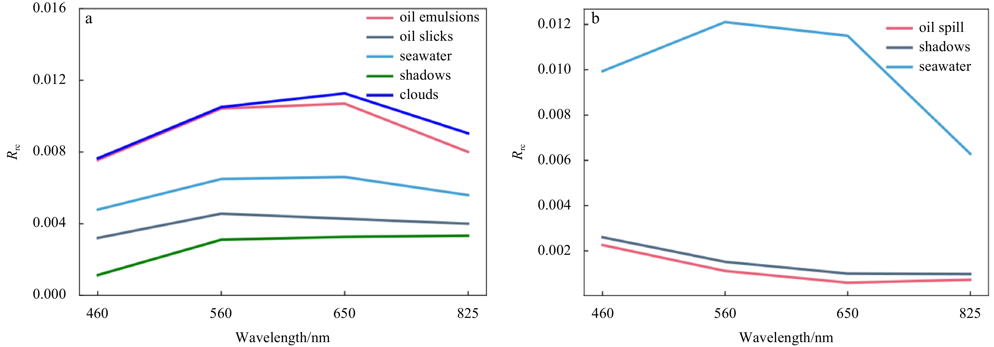
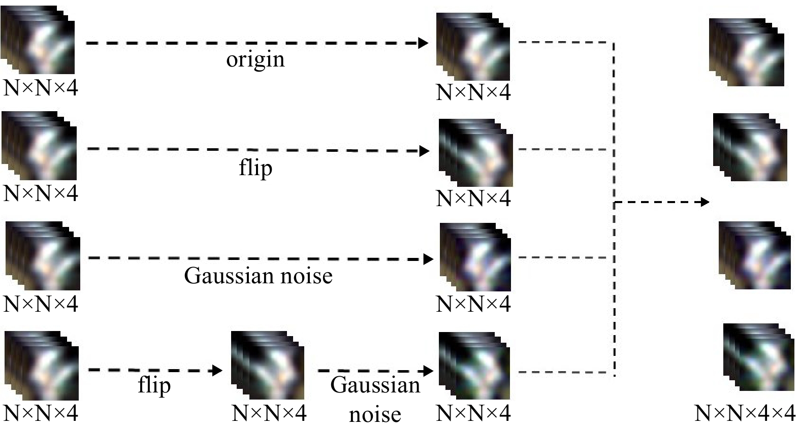
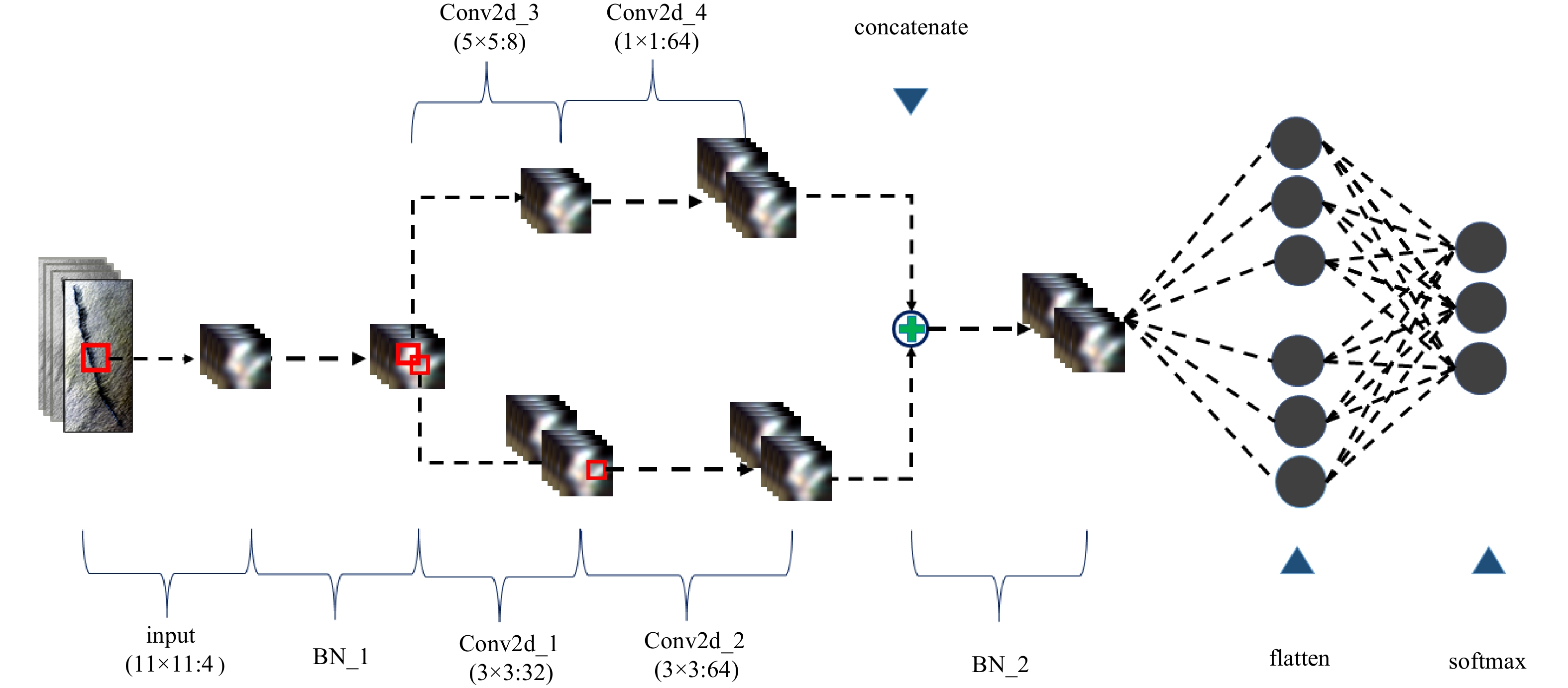
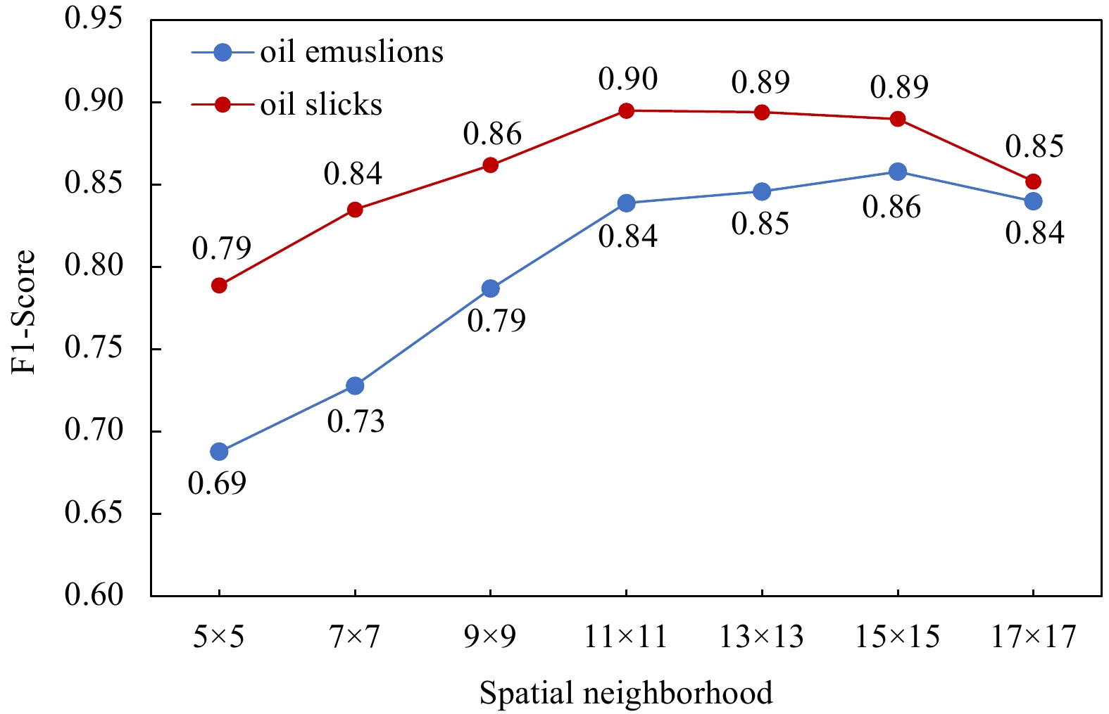
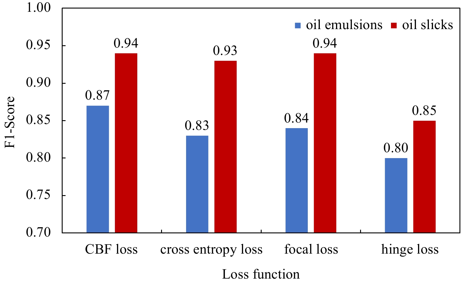
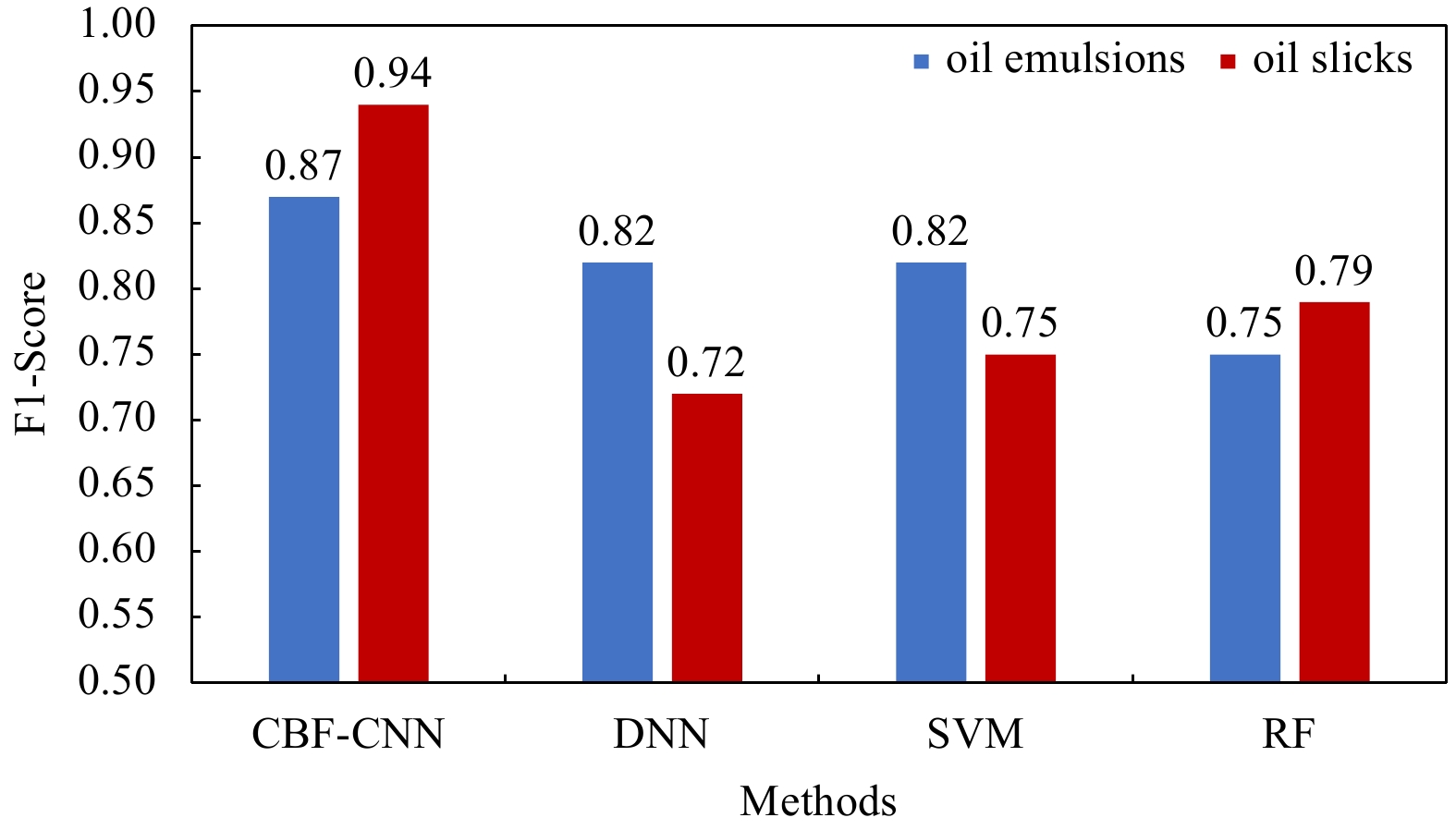
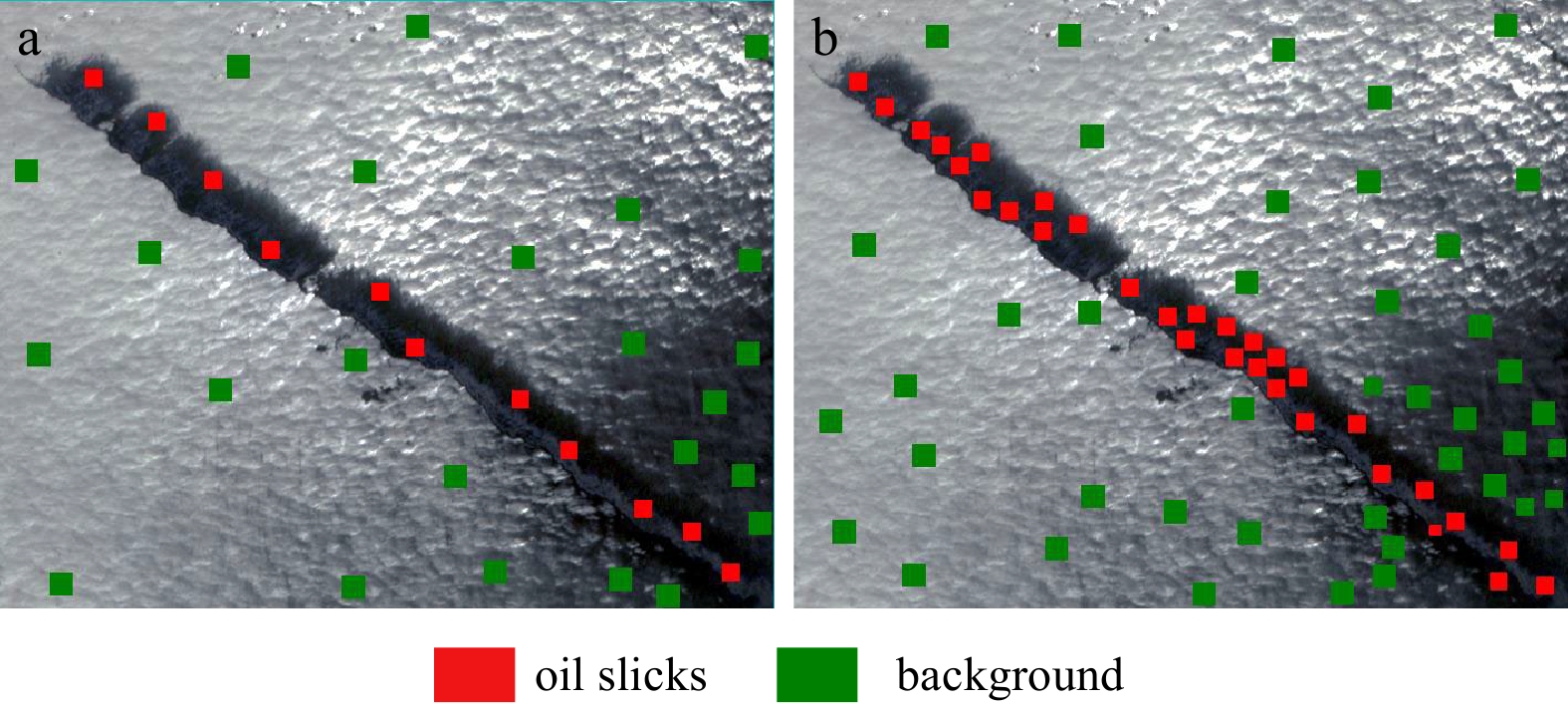
Accurate detection of an oil spill is of great significance for rapid response to oil spill accidents. Multispectral images have the advantages of high spatial resolution, short revisit period, and wide imaging width, which is suitable for large-scale oil spill monitoring. However, in wide remote sensing images, the number of oil spill samples is generally far less than that of seawater samples. Moreover, the sea surface state tends to be heterogeneous over a large area, which makes the identification of oil spills more difficult because of various sea conditions and sunglint. To address this problem, we used the F-Score as a measure of the distance between forecast value and true value, proposed the Class-Balanced F loss function (CBF loss function) that comprehensively considers the precision and recall, and rebalances the loss according to the actual sample numbers of various classes. Using the CBF loss function, we constructed convolution neural networks (CBF-CNN) for oil spill detection. Based on the image acquired by the Coastal Zone Imager (CZI) of the Haiyang-1C (HY-1C) satellite in the Andaman Sea (study area 1), we carried out parameter adjustment experiments. In contrast to experiments of different loss functions, the F1-Score of the detection result of oil emulsions is 0.87, which is 0.03–0.07 higher than cross-entropy, hinge, and focal loss functions, and the F1-Score of the detection result of oil slicks is 0.94, which is 0.01–0.09 higher than those three loss functions. In comparison with the experiment of different methods, the F1-Score of CBF-CNN for the detection result of oil emulsions is 0.05–0.12 higher than that of the deep neural networks, supports vector machine and random forests models, and the F1-Score of the detection result of oil slicks is 0.15–0.22 higher than that of the three methods. To verify the applicability of the CBF-CNN model in different observation scenes, we used the image obtained by HY-1C CZI in the Karimata Strait to carry out experiments, which include two studies areas (study area 2 and study area 3). The experimental results show that the F1-Score of CBF-CNN for the detection result of oil emulsions is 0.88, which is 0.16–0.24 higher than that of other methods, and the F1-Score of the detection result of oil slicks is 0.96–0.97, which is 0.06–0.23 higher than that of other methods. Based on all the above experiments, we come to the conclusions that the CBF loss function can restrain the influence of oil spill and seawater sample imbalance on oil spill detection of CNN model thus improving the detection accuracy of oil spills, and our CBF-CNN model is suitable for the detection of oil spills in an area with weak sunglint and can be applied to different scenarios of CZI images.
Accurate detection of an oil spill is of great significance for rapid response to oil spill accidents. Multispectral images have the advantages of high spatial resolution, short revisit period, and wide imaging width, which is suitable for large-scale oil spill monitoring. However, in wide remote sensing images, the number of oil spill samples is generally far less than that of seawater samples. Moreover, the sea surface state tends to be heterogeneous over a large area, which makes the identification of oil spills more difficult because of various sea conditions and sunglint. To address this problem, we used the F-Score as a measure of the distance between forecast value and true value, proposed the Class-Balanced F loss function (CBF loss function) that comprehensively considers the precision and recall, and rebalances the loss according to the actual sample numbers of various classes. Using the CBF loss function, we constructed convolution neural networks (CBF-CNN) for oil spill detection. Based on the image acquired by the Coastal Zone Imager (CZI) of the Haiyang-1C (HY-1C) satellite in the Andaman Sea (study area 1), we carried out parameter adjustment experiments. In contrast to experiments of different loss functions, the F1-Score of the detection result of oil emulsions is 0.87, which is 0.03–0.07 higher than cross-entropy, hinge, and focal loss functions, and the F1-Score of the detection result of oil slicks is 0.94, which is 0.01–0.09 higher than those three loss functions. In comparison with the experiment of different methods, the F1-Score of CBF-CNN for the detection result of oil emulsions is 0.05–0.12 higher than that of the deep neural networks, supports vector machine and random forests models, and the F1-Score of the detection result of oil slicks is 0.15–0.22 higher than that of the three methods. To verify the applicability of the CBF-CNN model in different observation scenes, we used the image obtained by HY-1C CZI in the Karimata Strait to carry out experiments, which include two studies areas (study area 2 and study area 3). The experimental results show that the F1-Score of CBF-CNN for the detection result of oil emulsions is 0.88, which is 0.16–0.24 higher than that of other methods, and the F1-Score of the detection result of oil slicks is 0.96–0.97, which is 0.06–0.23 higher than that of other methods. Based on all the above experiments, we come to the conclusions that the CBF loss function can restrain the influence of oil spill and seawater sample imbalance on oil spill detection of CNN model thus improving the detection accuracy of oil spills, and our CBF-CNN model is suitable for the detection of oil spills in an area with weak sunglint and can be applied to different scenarios of CZI images.


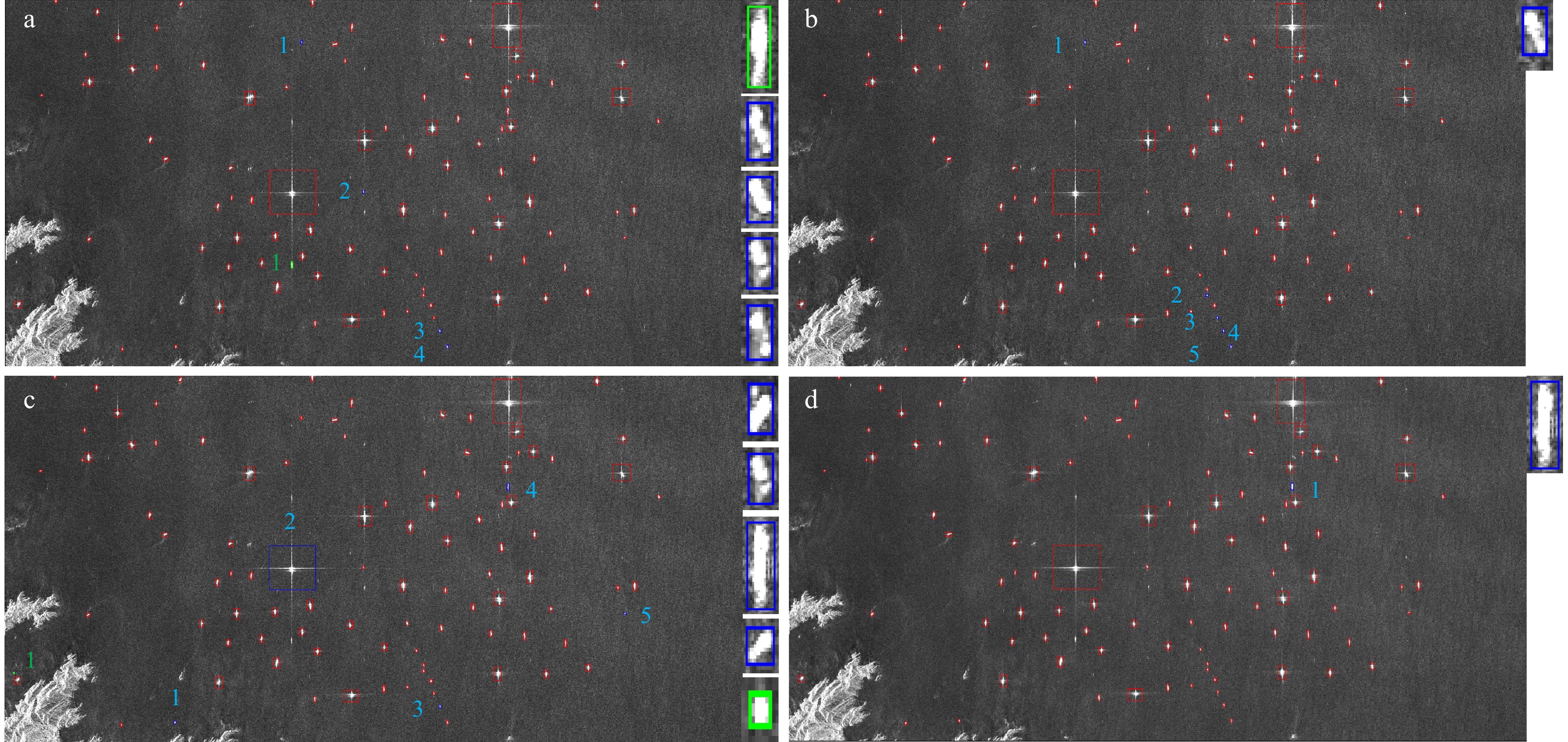
2022, 41(7): 180-192.
doi: 10.1007/s13131-021-1980-2
Abstract:
Ship detection using synthetic aperture radar (SAR) plays an important role in marine applications. The existing methods are capable of quickly obtaining many candidate targets, but numerous non-ship objects may be wrongly detected in complex backgrounds. These non-ship false alarms can be excluded by training discriminators, and the desired accuracy is obtained with enough verified samples. However, the reliable verification of targets in large-scene SAR images still inevitably requires manual interpretation, which is difficult and time consuming. To address this issue, a semisupervised heterogeneous ensemble ship target discrimination method based on a tri-training scheme is proposed to take advantage of the plentiful candidate targets. Specifically, various features commonly used in SAR image target discrimination are extracted, and several acknowledged classification models and their classic variants are investigated. Multiple discriminators are constructed by dividing these features into different groups and pairing them with each model. Then, the performance of all the discriminators is tested, and better discriminators are selected for implementing the semisupervised training process. These strategies enhance the diversity and reliability of the discriminators, and their heterogeneous ensemble makes more correct judgments on candidate targets, which facilitates further positive training. Experimental results demonstrate that the proposed method outperforms traditional tri-training.
Ship detection using synthetic aperture radar (SAR) plays an important role in marine applications. The existing methods are capable of quickly obtaining many candidate targets, but numerous non-ship objects may be wrongly detected in complex backgrounds. These non-ship false alarms can be excluded by training discriminators, and the desired accuracy is obtained with enough verified samples. However, the reliable verification of targets in large-scene SAR images still inevitably requires manual interpretation, which is difficult and time consuming. To address this issue, a semisupervised heterogeneous ensemble ship target discrimination method based on a tri-training scheme is proposed to take advantage of the plentiful candidate targets. Specifically, various features commonly used in SAR image target discrimination are extracted, and several acknowledged classification models and their classic variants are investigated. Multiple discriminators are constructed by dividing these features into different groups and pairing them with each model. Then, the performance of all the discriminators is tested, and better discriminators are selected for implementing the semisupervised training process. These strategies enhance the diversity and reliability of the discriminators, and their heterogeneous ensemble makes more correct judgments on candidate targets, which facilitates further positive training. Experimental results demonstrate that the proposed method outperforms traditional tri-training.