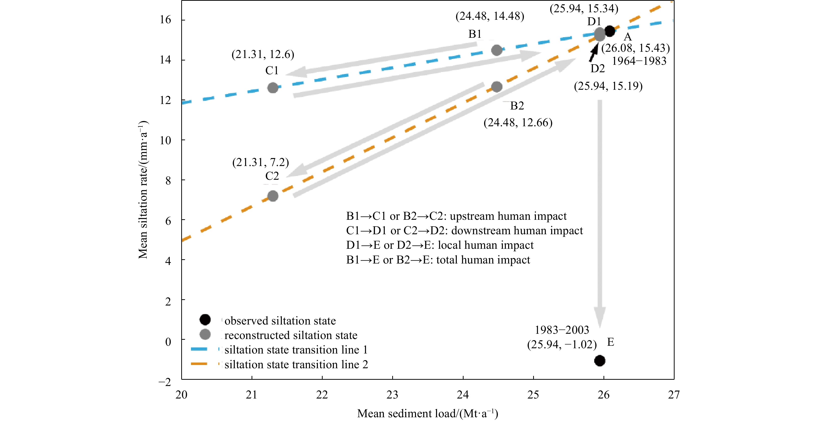
| Citation: | Tiehan Liao, Haigang Zhan, Xing Wei, Weikang Zhan. Impacts of human activities on morphological evolution in the Modaomen Estuary, China[J]. Acta Oceanologica Sinica, 2023, 42(5): 79-92. doi: 10.1007/s13131-022-2064-7

|

|
Acciarri A, Bisci C, Cantalamessa G, et al. 2016. Anthropogenic influence on recent evolution of shorelines between the Conero Mt. and the Tronto R. mouth (southern Marche, Central Italy). CATENA, 147: 545–555. doi: 10.1016/j.catena.2016.08.018
|
|
Besset M, Anthony E J, Bouchette F. 2019. Multi-decadal variations in delta shorelines and their relationship to river sediment supply: an assessment and review. Earth-Science Reviews, 193: 199–219. doi: 10.1016/j.earscirev.2019.04.018
|
|
Chen Xiaowen, Liu Xia, Zhang Wei. 2011. Shore reclamation in Zhujiang River Esturay and its impact analysis. Journal of Hohai University (Natural Sciences) (in Chinese), 39(1): 39–43
|
|
Chu Zhongxin, Yang Xuhui, Feng Xiuli, et al. 2013. Temporal and spatial changes in coastline movement of the Yangtze Delta during 1974–2010. Journal of Asian Earth Sciences, 66: 166–174. doi: 10.1016/j.jseaes.2013.01.002
|
|
Cooper J A G, Pilkey O H. 2004. Sea-level rise and shoreline retreat: time to abandon the Bruun Rule. Global and Planetary Change, 43(3–4): 157–171
|
|
Cowart L, Walsh J P, Corbett D R. 2010. Analyzing estuarine shoreline change: a case study of cedar Island, North Carolina. Journal of Coastal Research, 26(5): 817–830
|
|
Cui Buli, Li Xiaoyan. 2011. Coastline change of the Yellow River Estuary and its response to the sediment and runoff (1976–2005). Geomorphology, 127(1–2): 32–40
|
|
Cunliffe A M, Tanski G, Radosavljevic B, et al. 2019. Rapid retreat of permafrost coastline observed with aerial drone photogrammetry. The Cryosphere, 13(5): 1513–1528. doi: 10.5194/tc-13-1513-2019
|
|
Dai Zhijun. 2021. Changjiang Riverine and Estuarine Hydro-morphodynamic Processes: in the Context of Anthropocene Era. Singapore: Springer
|
|
Dai Zhijun, Liu J T. 2013. Impacts of large dams on downstream fluvial sedimentation: an example of the Three Gorges Dam (TGD) on the Changjiang (Yangtze River). Journal of Hydrology, 480: 10–18. doi: 10.1016/j.jhydrol.2012.12.003
|
|
Dai Zhijun, Liu J T, Wei Wen, et al. 2014. Detection of the Three Gorges Dam influence on the Changjiang (Yangtze River) submerged delta. Scientific Reports, 4: 6600. doi: 10.1038/srep06600
|
|
Dai Shibao, Lu Xixi. 2014. Sediment load change in the Yangtze River (Changjiang): a review. Geomorphology, 215: 60–73. doi: 10.1016/j.geomorph.2013.05.027
|
|
Dai Zhijun, Mei Xuefei, Darby S E, et al. 2018. Fluvial sediment transfer in the Changjiang (Yangtze) river-estuary depositional system. Journal of Hydrology, 566: 719–734. doi: 10.1016/j.jhydrol.2018.09.019
|
|
Dai Shibao, Yang Shilun, Cai Aimin. 2008. Impacts of dams on the sediment flux of the Zhujiang River, southern China. CATENA, 76(1): 36–43. doi: 10.1016/j.catena.2008.08.004
|
|
Day J W, Giosan L. 2008. Survive or subside?. Nature Geoscience, 1(3): 156–157
|
|
Dean R G, Houston J R. 2016. Determining shoreline response to sea level rise. Coastal Engineering, 114: 1–8. doi: 10.1016/j.coastaleng.2016.03.009
|
|
Fanos A M. 1995. The impact of human activities on the erosion and accretion of the Nile Delta coast. Journal of Coastal Research, 11(3): 821–833
|
|
Fearnley S M, Miner M D, Kulp M, et al. 2009. Hurricane impact and recovery shoreline change analysis of the Chandeleur Islands, Louisiana, USA: 1855 to 2005. Geo-Marine Letters, 29(6): 455–466. doi: 10.1007/s00367-009-0155-5
|
|
Ford M. 2013. Shoreline changes interpreted from multi-temporal aerial photographs and high resolution satellite images: Wotje Atoll, Marshall Islands. Remote Sensing of Environment, 135: 130–140. doi: 10.1016/j.rse.2013.03.027
|
|
Frihy O E, Debes E A, El Sayed W R. 2003. Processes reshaping the Nile delta promontories of Egypt: pre- and post-protection. Geomorphology, 53(3–4): 263–279
|
|
Gellis A C, Noe G B. 2013. Sediment source analysis in the Linganore Creek watershed, Maryland, USA, using the sediment fingerprinting approach: 2008 to 2010. Journal of Soils and Sediments, 13(10): 1735–1753. doi: 10.1007/s11368-013-0771-6
|
|
Gong Wenping, Shen Jian. 2011. The response of salt intrusion to changes in river discharge and tidal mixing during the dry season in the Modaomen Estuary, China. Continental Shelf Research, 31(7–8): 769–788
|
|
Grill G, Lehner B, Thieme M, et al. 2019. Mapping the world’s free-flowing rivers. Nature, 569(7755): 215–221. doi: 10.1038/s41586-019-1111-9
|
|
Han Zhiyuan, Tian Xiangping, Ou Suying. 2010. Impacts of Large-scale human activities on riverbed morphology and tidal dynamics at modaomen estuary. Scientia Geographica Sinica (in Chinese), 30(4): 582–587
|
|
Hansen J E, Elias E, List J H, et al. 2013. Tidally influenced alongshore circulation at an inlet-adjacent shoreline. Continental Shelf Research, 56: 26–38. doi: 10.1016/j.csr.2013.01.017
|
|
Healy M G, Hickey K R. 2002. Historic land reclamation in the intertidal wetlands of the Shannon Estuary, western Ireland. Journal of Coastal Research, 36(10036): 365–373
|
|
Hillel D. 2013. Introduction to Soil Physics. New York: Academic Press
|
|
Himmelstoss E A, Henderson R E, Kratzmann M G, et al. 2018. Digital shoreline analysis system (DSAS) version 5.0 user guide. Reston: U. S. Geological Survey
|
|
Jia Liangwen, Pan Shunqi, Wu Chaoyu. 2013. Effects of the anthropogenic activities on the morphological evolution of the Modaomen Estuary, Zhujiang River Delta, China. China Ocean Engineering, 27(6): 795–808. doi: 10.1007/s13344-013-0065-1
|
|
Jones B M, Grosse G, Arp C D, et al. 2011. Modern thermokarst lake dynamics in the continuous permafrost zone, northern Seward Peninsula, Alaska. Journal of Geophysical Research: Biogeosciences, 116(G2): G00M03
|
|
Kong Dongxian, Miao Chiyuan, Borthwick A G L, et al. 2015. Evolution of the Yellow River Delta and its relationship with runoff and sediment load from 1983 to 2011. Journal of Hydrology, 520: 157–167. doi: 10.1016/j.jhydrol.2014.09.038
|
|
Lehner B, Liermann C R, Revenga C, et al. 2011. High-resolution mapping of the world’s reservoirs and dams for sustainable river-flow management. Frontiers in Ecology and the Environment, 9(9): 494–502. doi: 10.1890/100125
|
|
Liu Feng, Hu Shuai, Guo Xiaojuan, et al. 2018. Recent changes in the sediment regime of the Zhujiang River (South China): causes and implications for the Zhujiang River Delta. Hydrological Processes, 32(12): 1771–1785. doi: 10.1002/hyp.11513
|
|
Liu Feng, Tian Xiangping, Han Zhiyuan, et al. 2011. Analysis of river channel evolution of Modaomen channel of Xijiang River in past forty years. Journal of Sediment Research (in Chinese), (1): 45–50
|
|
Liu Feng, Yuan Lirong, Yang Qingshu, et al. 2014. Hydrological responses to the combined influence of diverse human activities in the Zhujiang River Delta, China. CATENA, 113: 41–55. doi: 10.1016/j.catena.2013.09.003
|
|
Loveland T R, Dwyer J L. 2012. Landsat: building a strong future. Remote Sensing of Environment, 122: 22–29. doi: 10.1016/j.rse.2011.09.022
|
|
Luo Xiangxin, Yang Shilun, Zhang Jing. 2012. The impact of the Three Gorges Dam on the downstream distribution and texture of sediments along the middle and lower Yangtze River (Changjiang) and its estuary, and subsequent sediment dispersal in the East China Sea. Geomorphology, 179: 126–140. doi: 10.1016/j.geomorph.2012.05.034
|
|
Luo Xianlin, Zeng E Y, Ji Rongyao, et al. 2007. Effects of in-channel sand excavation on the hydrology of the Zhujiang River Delta, China. Journal of Hydrology, 343(3–4): 230–239
|
|
Matin N, Hasan G M J. 2021. A quantitative analysis of shoreline changes along the coast of Bangladesh using remote sensing and GIS techniques. CATENA, 201: 105185. doi: 10.1016/j.catena.2021.105185
|
|
McFeeters S K. 1996. The use of the Normalized Difference Water Index (NDWI) in the delineation of open water features. International Journal of Remote Sensing, 17(7): 1425–1432. doi: 10.1080/01431169608948714
|
|
Meade R H. 1982. Sources, sinks, and storage of river sediment in the Atlantic drainage of the United States. The Journal of Geology, 90(3): 235–252. doi: 10.1086/628677
|
|
Mei Xuefei, Dai Zhijun, Du Jinzhou, et al. 2015. Linkage between Three Gorges Dam impacts and the dramatic recessions in China’s largest freshwater lake, Poyang Lake. Scientific Reports, 5: 18197. doi: 10.1038/srep18197
|
|
Nilsson C, Reidy C A, Dynesius M, et al. 2005. Fragmentation and flow regulation of the world’s large river systems. Science, 308(5720): 405–408. doi: 10.1126/science.1107887
|
|
Pritchard D W. 1967. What is an estuary: physical viewpoint. American Association for the Advancement of Science, 83: 3–5
|
|
Roccati A, Faccini F, Luino F, et al. 2019. Morphological changes and human impact in the Entella River floodplain (Northern Italy) from the 17th century. CATENA, 182: 104122. doi: 10.1016/j.catena.2019.104122
|
|
San-Nami T, Uda T, Onaka S. 2013. Long-term shoreline recession on eastern Bali Coast caused by riverbed mining. In: Proceedings of the 7th International Conference on Asian and Pacific Coasts. Bali: Hasanuddin University, 275–282
|
|
Stanley D J, Warne A G. 1993. Nile delta: recent geological evolution and human impact. Science, 260(5108): 628–634. doi: 10.1126/science.260.5108.628
|
|
Thieler E R, Himmelstoss E A, Zichichi J L, et al. 2009. The digital shoreline analysis system (DSAS) version 4.0-An ArcGIS extension for calculating shoreline change. Reston: U. S. Geological Survey
|
|
van der Wal D, Pye K, Neal A. 2002. Long-term morphological change in the Ribble Estuary, northwest England. Marine Geology, 189(3–4): 249–266
|
|
Wang Jie, Dai Zhijun, Mei Xuefei, et al. 2020. Tropical cyclones significantly alleviate mega—deltaic erosion induced by high riverine flow. Geophysical Research Letters, 47(19): e2020GL089065
|
|
Wei Xing, Cai Shuqun, Zhan Weikang. 2021. Impact of anthropogenic activities on morphological and deposition flux changes in the Zhujiang River Estuary, China. Scientific Reports, 11(1): 16643. doi: 10.1038/s41598-021-96183-0
|
|
Wu Ziyin, Milliman J D, Zhao Dineng, et al. 2018. Geomorphologic changes in the lower Zhujiang River Delta, 1850–2015, largely due to human activity. Geomorphology, 314: 42–54. doi: 10.1016/j.geomorph.2018.05.001
|
|
Wu Ziyin, Saito Y, Zhao Dineng, et al. 2016a. Impact of human activities on subaqueous topographic change in Lingding Bay of the Zhujiang River Estuary, China, during 1955–2013. Scientific Reports, 6: 37742. doi: 10.1038/srep37742
|
|
Wu Chuangshou, Yang Shilun, Huang Shichang, et al. 2016b. Delta changes in the Zhujiang River Estuary and its response to human activities (1954–2008). Quaternary International, 392: 147–154. doi: 10.1016/j.quaint.2015.04.009
|
|
Yang Shilun, Belkin I M, Belkina A I, et al. 2003. Delta response to decline in sediment supply from the Yangtze River: evidence of the recent four decades and expectations for the next half-century. Estuarine, Coastal and Shelf Science, 57(4): 689–699
|
|
Yang Liuzhu, Liu Feng, Gong Wenping, et al. 2019. Morphological response of Lingding Bay in the Zhujiang River Estuary to human intervention in recent decades. Ocean & Coastal Management, 176: 1–10
|
|
Yang Shilun, Milliman J D, Li Peng, et al. 2011. 50, 000 dams later: erosion of the Yangtze River and its delta. Global and Planetary Change, 75(1–2): 14–20
|
|
Yang Zuosheng, Wang Houjie, Saito Y, et al. 2006. Dam impacts on the Changjiang (Yangtze) River sediment discharge to the sea: the past 55 years and after the Three Gorges Dam. Water Resources Research, 42(4): W04407
|
|
Yang Shilun, Zhang Jianbo, Xu Xiaojun. 2007. Influence of the Three Gorges Dam on downstream delivery of sediment and its environmental implications, Yangtze River. Geophysical Research Letters, 34(10): L10401. doi: 10.1029/2007GL029472
|
|
Zhang Shurong, Lu Xixi. 2009. Hydrological responses to precipitation variation and diverse human activities in a mountainous tributary of the lower Xijiang, China. CATENA, 77(2): 130–142. doi: 10.1016/j.catena.2008.09.001
|
|
Zhang Qiang, Xu Chongyu, Chen Yongqin David, et al. 2009. Abrupt behaviors of the streamflow of the Zhujiang River basin and implications for hydrological alterations across the Zhujiang River Delta, China. Journal of Hydrology, 377(3–4): 274–283
|
|
Zhang Wei, Xu Yang, Hoitink A J F, et al. 2015. Morphological change in the Zhujiang River Delta, China. Marine Geology, 363: 202–219. doi: 10.1016/j.margeo.2015.02.012
|
|
Zhu Meisha, Sun Tao, Shao Dongdong. 2016. Impact of land reclamation on the evolution of shoreline change and nearshore vegetation distribution in Yangtze River Estuary. Wetlands, 36(S1): 11–17. doi: 10.1007/s13157-014-0610-6
|

Figures(11) / Tables(8)

Supported by:
Beijing Renhe Information Technology Co. Ltd


 DownLoad: