

Tsunami hazard and mitigation analysis for bathing beaches in China based on numerical simulations
-
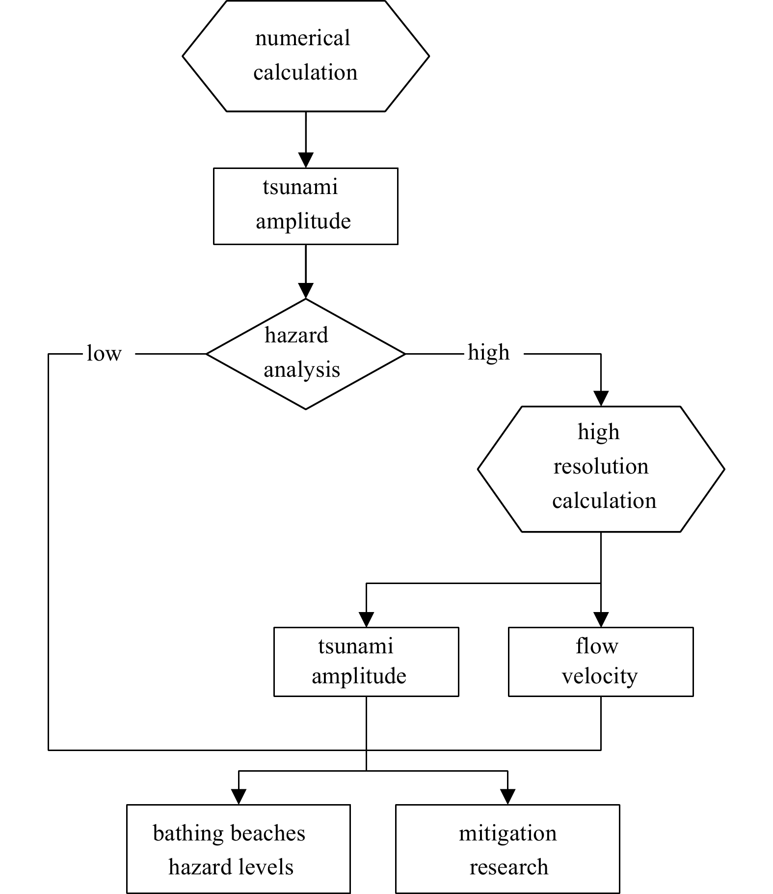
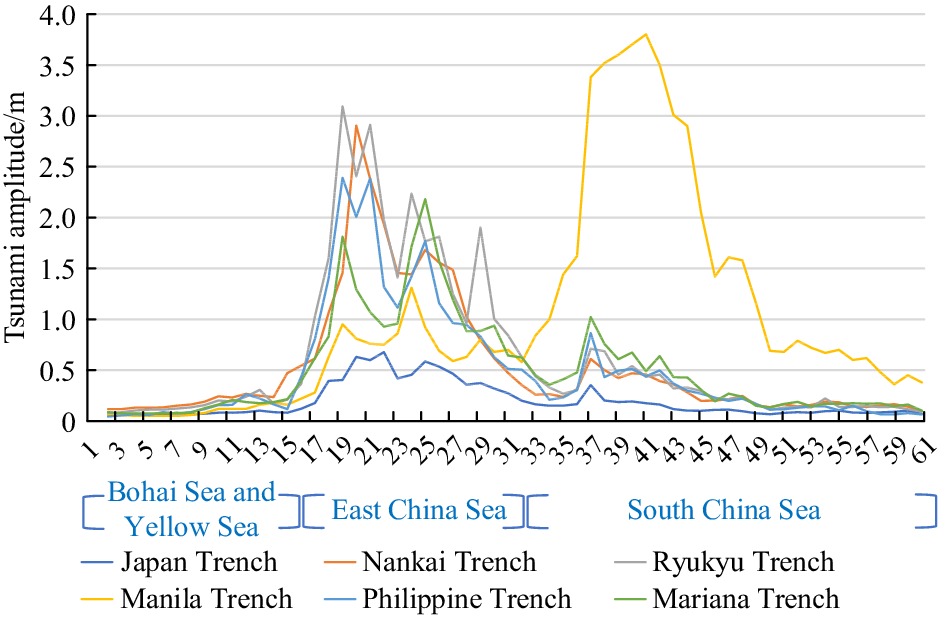
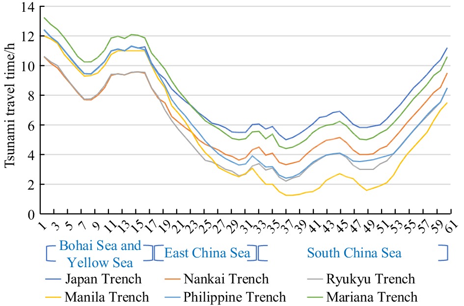
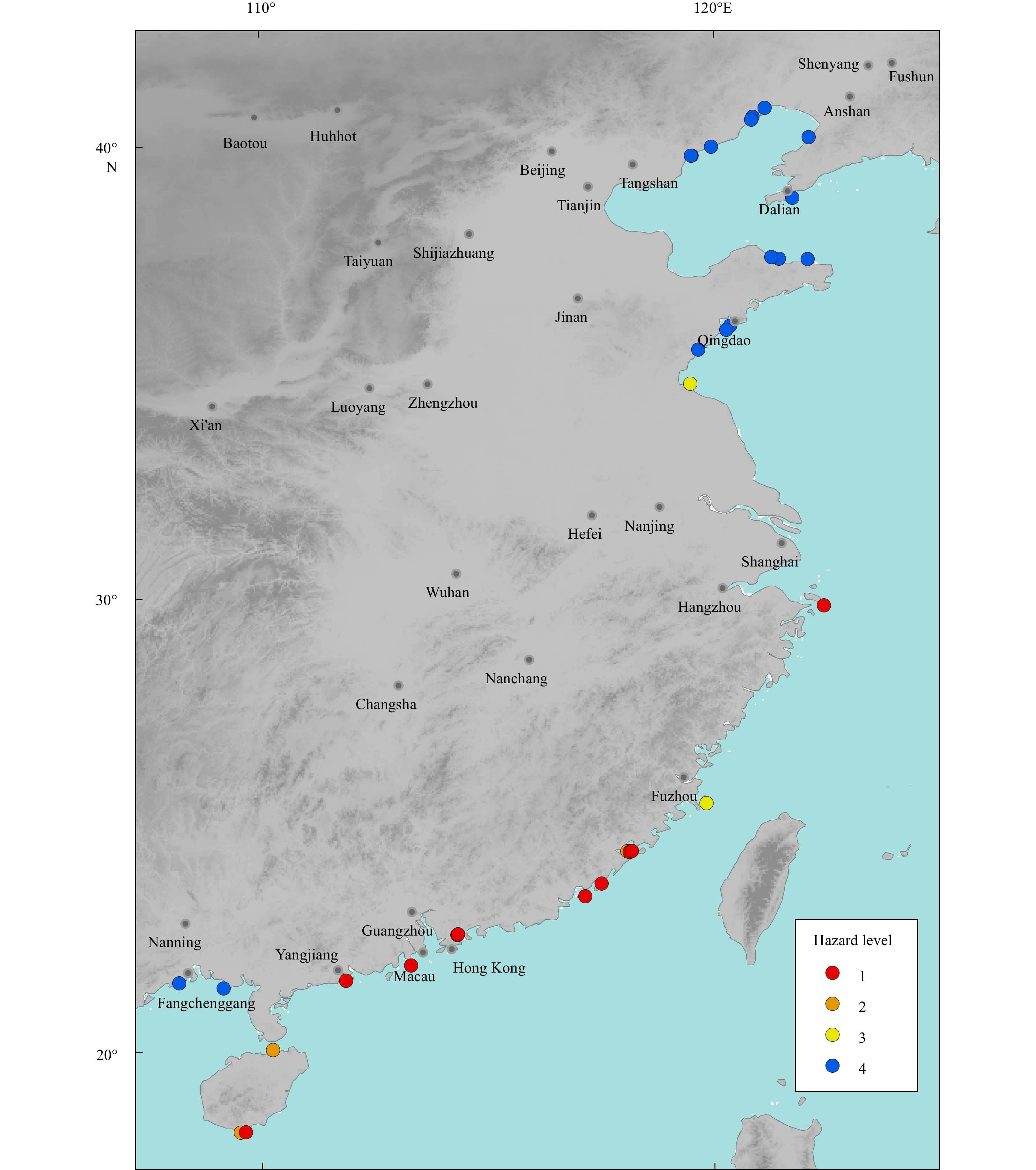
Abstract: Bathing beaches are usually the first to suffer disasters when tsunamis occur, owing to their proximity to the sea. Several large seismic fault zones are located off the coast of China. The impact of each tsunami scenario on Chinese bathing beaches is different. In this study, numerical models of the worst tsunami scenarios associated with seismic fault zones were considered to assess the tsunami hazard of bathing beaches in China. Numerical results show that tsunami waves from the Pacific Ocean could affect the East China Sea coast through gaps between the Ryukyu Islands. The Zhejiang and Shanghai coasts would be threatened by a tsunami from Ryukyu Trench, and the coasts of Hainan and Guangdong provinces would be threatened by a tsunami from the Manila Trench. The tsunami hazard associated with the Philippine Trench scenario needs particular attention. Owing to China’s offshore topography, the sequential order of tsunami arrival times to coastal provinces in several tsunami scenarios is almost the same. According to the tsunami hazard analysis results, Yalongwan Beach and eight other bathing beaches are at the highest hazard level. A high-resolution numerical calculation model was established to analyze the tsunami physical characteristics for the high-risk bathing beaches. To explore mitigating effects of a tsunami disaster, this study simulated tsunami propagation with the addition of seawalls. The experimental results show that the tsunami prevention seawalls constructed in an appropriate shallow water location have some effect on reducing tsunami hazard. Seawalls separated by a certain distance work even better. The analysis results can provide a scientific reference for subsequent preventive measures such as facility construction and evacuation.
-
Key words:
- tsunami /
- bathing beach /
- hazard /
- mitigation
-
Table 1. Magnitudes and locations of tsunami sources
Location Latitude, longitude Mw Japan Trench 38.24°N, 142.37°E 9.0 Nankai Trough 31.83°N, 133.50°E 9.0 Ryukyu Trench 25.68°N, 128.81°E 9.0 Manila Trench 18.97°N, 120.57°E 9.0 Philippine Trench 13.70°N, 125.33°E 9.0 Mariana Trench 12.50°N, 142.50°E 9.0  下载: 导出CSV
Table 2. Parameters of Model A
Layer Bathymetric
dataRegional extent Governing
equationSpatial
resolutionLayer 1 ETOPO2 5.0°–52.0°N, linear 2' 99.0°–157.0°E Layer 2 SRTM plus15 34.7°–41.6°N, nonlinear (1/4)' 117.2°–124.9°E; 23.1°–34.7°N, 117.2°–123.5°E; 17.4°–24.1°N, 107.3°–117.1°E
下载: 导出CSV
Table 3. Tsunami hazard level criteria
Hazard level Amplitude/m Color 1 >3 red 2 1–3 orange 3 0.3–1 yellow 4 <0.3 blue
下载: 导出CSV
Table 4. The parameters of Layer 3
Layer Bathymetric
dataRegional extent Governing
equationsSpatial
resolutionLayer 3 nautical
chart29.8°–29.9°N,
122.4°–122.5°E;nonlinear (1/32)' 21.8°–22.0°N,
113.2°–113.3°E;
21.5°–21.6°N,
111.8°–111.9°E;
18.1°–18.3°N,
109.5°–109.7°E
下载: 导出CSV
Table 5. The maximum amplitude and flow velocity of tsunami scenarios
Bathing beach City Parameters Japan Trench Nankai Trough Ryukyu Trench Manila Trench Philippine Trench Mariana Trench Zhujiajian Zhoushan Amplitude/m 1.1 4.4 5.2 0.8 3.2 5.0 Velocity/(m·s−1) 0.5 0.6 3.9 0.1 1.2 2.4 Dajiaowan Yangjiang Amplitude/m 0.4 0.9 1.4 6.5 1.4 2.2 Velocity/(m·s−1) 0.1 0.3 0.5 4.3 0.4 0.5 Feishatan Zhuhai Amplitude/m 0.5 0.7 1.1 7.1 1.2 1.4 Velocity/(m·s−1) 0.2 0.1 0.2 4.8 0.2 0.5 Yalongwan Sanya Amplitude/m 0.3 1.0 1.2 3.5 0.8 1.1 Velocity/(m·s−1) 0.1 0.4 0.5 2.2 0.2 0.5
下载: 导出CSV
Table 6. Seawall experimental schemes
Length/m Width/m Height (msl)/m Offshore distance/m Shape Material Scheme 1 no additions no additions no additions no additions no additions no additions Scheme 2 70 30 10 400 cuboid concrete and plants 70 30 10 400 cuboid concrete and plants 70 30 10 400 cuboid concrete and plants 70 30 10 400 cuboid concrete and plants Scheme 3 280 30 10 400 cuboid concrete and plants Note: msl means mean sea level.
下载: 导出CSV
Table 7. Numerical simulation parameters
Layer Bathymetric data Regional extent Equation Resolution Layer 1 ETOPO2 5°S–52°N, 99°–157°E linear 2' Layer 2 SRTM plus15 17.4°–24.1°N, 107.3°–117.1°E nonlinear (1/4)' Layer 3 nautical chart 21.5°–21.6°N, 111.8°–111.9°E nonlinear (1/32)' Layer 4 nautical chart 21.56°–21.58°N, 111.83°–111.85°E nonlinear (1/256)'
下载: 导出CSV
-
Apotsos A, Jaffe B, Gelfenbaum G. 2011. Wave characteristic and morphologic effects on the onshore hydrodynamic response of tsunamis. Coastal Engineering, 58(11): 1034–1048. doi: 10.1016/j.coastaleng.2011.06.002 Borrero J C, Lynett P J, Kalligeris N. 2015. Tsunami currents in ports. Philosophical Transactions of the Royal Society A: Mathematical, Physical and Engineering Sciences, 373(2053): 20140372 Carrier G F, Wu T T, Yeh H. 2003. Tsunami run-up and draw-down on a plane beach. Journal of Fluid Mechanics, 475: 79–99. doi: 10.1017/S0022112002002653 Chan I C, Liu P L F. 2012. On the runup of long waves on a plane beach. Journal of Geophysical Research: Oceans, 117(C8): C08006 Feng Xingru, Yin Baoshu, Gao Song, et al. 2017. Assessment of tsunami hazard for coastal areas of Shandong Province, China. Applied Ocean Research, 62: 37–48. doi: 10.1016/j.apor.2016.12.001 Fritz H M, Phillips D A, Okayasu A, et al. 2012. The 2011 Japan tsunami current velocity measurements from survivor videos at Kesennuma Bay using LiDAR. Geophysical Research Letters, 39(7): L00G23 Hou Jingming, Li Xiaojuan, Wang Peitao, et al. 2020a. Hazard analysis of tsunami disaster on the Maritime Silk Road. Acta Oceanologica Sinica, 39(1): 74–82. doi: 10.1007/s13131-019-1526-z Hou Jingming, Yuan Ye, Li Tao, et al. 2020b. Tsunami hazard analysis for Chinese coast from potential earthquakes in the western North Pacific. Geomatics, Natural Hazards and Risk, 11(1): 967–983 Hsu Y J, Yu S B, Loveless J P, et al. 2016. Interseismic deformation and moment deficit along the Manila subduction zone and the Philippine Fault system. Journal of Geophysical Research: Solid Earth, 121(10): 7639–7665. doi: 10.1002/2016JB013082 Ioualalen M, Asavanant J, Kaewbanjak N, et al. 2007. Modeling the 26 December 2004 Indian Ocean tsunami: Case study of impact in Thailand. Journal of Geophysical Research: Oceans, 112(C7): C07024 Li Linlin, Switzer A D, Chan C H, et al. 2016. How heterogeneous coseismic slip affects regional probabilistic tsunami hazard assessment: A case study in the South China Sea. Journal of Geophysical Research: Solid Earth, 121(8): 6250–6272. doi: 10.1002/2016JB013111 Li Linlin, Switzer A D, Wang Yu, et al. 2018. A modest 0.5-m rise in sea level will double the tsunami hazard in Macau. Science Advances, 4(8): eaat1180. doi: 10.1126/sciadv.aat1180 Liu Yingchun, Santos A, Wang S M, et al. 2007. Tsunami hazards along Chinese coast from potential earthquakes in South China Sea. Physics of the Earth and Planetary Interiors, 163(1–4): 233–244 Lopez J A. 2009. The Multiple Lines of Defense Strategy to Sustain Coastal Louisiana. Journal of Coastal Research, 10054: 186–197. doi: 10.2112/SI54-020.1 Løvholt F, Glimsdal S, Harbitz C B, et al. 2014. Global tsunami hazard and exposure due to large co-seismic slip. International Journal of Disaster Risk Reduction, 10: 406–418. doi: 10.1016/j.ijdrr.2014.04.003 Lunghino B, Tate A F S, Mazereeuw M, et al. 2020. The protective benefits of tsunami mitigation parks and ramifications for their strategic design. Proceedings of the National Academy of Sciences of the United States of America, 117(20): 10740–10745. doi: 10.1073/pnas.1911857117 Lynett P J. 2007. Effect of a shallow water obstruction on long wave runup and overland flow velocity. Journal of Waterway, Port, Coastal, and Ocean Engineering, 133(6): 455–462 Lynett P J, Borrero J C, Weiss R, et al. 2012. Observations and modeling of tsunami-induced currents in ports and harbors. Earth and Planetary Science Letters, 327–328: 68–74 Madsen P A, Fuhrman D R, Schäffer H A. 2008. On the solitary wave paradigm for tsunamis. Journal of Geophysical Research: Oceans, 113(C12): C12012 Megawati K, Shaw F, Sieh K, et al. 2009. Tsunami hazard from the subduction megathrust of the South China Sea: Part I. Source characterization and the resulting tsunami. Journal of Asian Earth Sciences, 36(1): 13–20. doi: 10.1016/j.jseaes.2008.11.012 National Geophysical Data Center (NGDC). 2006. 2-minute Gridded Global Relief Data (ETOPO2) v2. NOAA National Centers for Environmental Information. http: //doi. org/10.7289/V5J1012Q[2021-01-15] National Geophysical Data Center (NGDC). 2021. World Data Service: NCEI/WDS Global Historical Tsunami Database. NOAA National Centers for Environmental Information. https://www.ncei.noaa.gov/access/metadata/landing-page/bin/iso?id=gov.noaa.ngdc.mgg.hazards:G02151[2021-01-15] Qiu Qiang, Li Linlin, Hsu Y J, et al. 2019. Revised earthquake sources along Manila trench for tsunami hazard assessment in the South China Sea. Natural Hazards and Earth System Sciences, 19(7): 1565–1583. doi: 10.5194/nhess-19-1565-2019 Ren Zhiyuan, Wang Yuchen, Wang Peitao, et al. 2020. Numerical study of the triggering mechanism of the 2018 Anak Krakatau tsunami: eruption or collapsed landslide?. Natural Hazards, 102(1): 1–13. doi: 10.1007/s11069-020-03907-y Ren Zhiyuan, Yuan Ye, Wang Peitao, et al. 2017. The September 16, 2015 MW 8.3 Illapel, Chile Earthquake: characteristics of tsunami wave from near-field to far-field. Acta Oceanologica Sinica, 36(5): 73–82. doi: 10.1007/s13131-017-1005-3 Sun Liguang, Zhou Xin, Huang Wen, et al. 2013. Preliminary evidence for a 1000-year-old tsunami in the South China Sea. Scientific Reports, 3(1): 1655. doi: 10.1038/srep01655 Syamsidik, Benazir, Luthfi M, et al. 2020. The 22 December 2018 Mount Anak Krakatau volcanogenic tsunami on Sunda Strait coasts, Indonesia: tsunami and damage characteristics. Natural Hazards and Earth System Sciences, 20(2): 549–565. doi: 10.5194/nhess-20-549-2020 Tonkin S, Yeh H, Kato F, et al. 2003. Tsunami scour around a cylinder. Journal of Fluid Mechanics, 496: 165–192. doi: 10.1017/S0022112003006402 Tozer B, Sandwell D T, Smith W H F, et al. 2019. Global bathymetry and topography at 15 arc sec: SRTM15+. Earth and Space Science, 6(10): 1847–1864. doi: 10.1029/2019EA000658 Wang Xiaoming. 2009. User manual for COMCOT version 1.7 (first draft). Ithaca, NY: Cornel University, 65 Wang Xiaoming, Liu P L F. 2006. An analysis of 2004 Sumatra earthquake fault plane mechanisms and Indian Ocean tsunami. Journal of Hydraulic Research, 44(2): 147–154. doi: 10.1080/00221686.2006.9521671 Wang Peitao, Ren Zhiyuan, Sun Lining, et al. 2021. Observations and modelling of the travel time delay and leading negative phase of the 16 September 2015 Illapel, Chile tsunami. Acta Oceanologica Sinica, 40(11): 11–30. doi: 10.1007/s13131-021-1830-2 Wang Peitao, Yu Fujiang, Zhao Lianda, et al. 2012. Numerical analysis of tsunami propagating generated by the Japan MW 9.0 earthquake on Mar. 11 in 2011 and its impact on China coasts. Chinese Journal of Geophysics, 55(9): 3088–3096 Wei Yong, Chamberlin C, Titov V V, et al. 2013. Modeling of the 2011 Japan tsunami: lessons for near-field forecast. Pure and Applied Geophysics, 170(6–8): 1309–1331 Wilson R, Davenport C, Jaffe B. 2012. Sediment scour and deposition within harbors in California (USA), caused by the March 11, 2011 Tohoku-oki tsunami. Sedimentary Geology, 282: 228–240. doi: 10.1016/j.sedgeo.2012.06.001 Zhang Mingliang, Ji Yongpeng, Wang Yini, et al. 2020. Numerical investigation on tsunami wave mitigation on forest sloping beach. Acta Oceanologica Sinica, 39(1): 130–140. doi: 10.1007/s13131-019-1527-y Zhao Xi, Liu Hua, Wang Benlong. 2013. Evolvement of tsunami waves on the continental shelves with gentle slope in the China Seas. Theoretical and Applied Mechanics Letters, 3(3): 032005. doi: 10.1063/2.1303205 -


 点击查看大图

图(10) / 表(7)
计量
- 文章访问数: 603
- HTML全文浏览量: 187
- PDF下载量: 35
- 被引次数: 0

