

Study of coexisting upstream solitary wave packet and downstream wakes induced by Diaoyu Dao and its affiliated islands detected by satellite sun glitter
-
Abstract: Taking the advantage of sun glitter (SG) observed from high-resolution satellites Gaofen-1 (GF-1) and Gaofen-6 (GF-6), a new method named Shield and Vortex 1-2 (SAV1-2) for extracting spatial texture information from sun glitter was established. Sea surface texture detail information around Diaoyu Dao and its affiliated islands was extracted using SAV1-2. Meanwhile, the dynamic characteristics of the water environment were analyzed by combining the water color, temperature and dynamic data. The results show the following information. (1) Stable westward shield effect and eastward Karman vortex streets, extracted from SG, appear upstream (westward) and downstream (eastward) of the Diaoyu Dao and its affiliated islands respectively. (2) The dominant direction of the Kuroshio Current in the Diaoyu Dao and its affiliated islands area is east, the Diaoyu Dao and its affiliated islands interacting with Kuroshio, inducing western shield and eastern shelter and wake. Furthermore, wave intervals of the shield in front of the island range from hundreds to thousands of metres, and extend wider than the island itself. (3) Combining with high-resolution sea surface temperature (SST) and chlorophyll a (Chl a) concentration, the directional changes of water color elements are mutually supported and proved with the stable shield (wave packet) effect in the west and vortex street effect in the east. The change of SST upstream of the island (western shield area) is not significant, the temperature in the downstream shelter area decreases slightly, and the SST in the downstream wake area shows a general trend of obvious decrease. The wake area is dominated by Karman vortex streets in shape, supplementing by vortices. The concentration of Chl a in the west shield of island is as low as that in downstream shelter area, while it increases significantly in the downstream wake area with shape in eddy or ribbon. (4) The SAV methods of extracting sea surface texture detail using SG can be widely used in different sea areas and water quality. This paper can provide reference for the protection and development of Diaoyu Dao and its affiliated islands and its surrounding waters. It is suggested that some kind of current buffer, such as marine wind farm, should be established in the western waters of Diaoyu Dao and its affiliated islands to protect the islands, and marine pasture should be developed in the downstream of eastern waters of Diaoyu Dao and its affiliated islands.
-
Key words:
- sun glitter /
- westward shield /
- Diaoyu Dao and its affiliated islands /
- GF-1/6
-
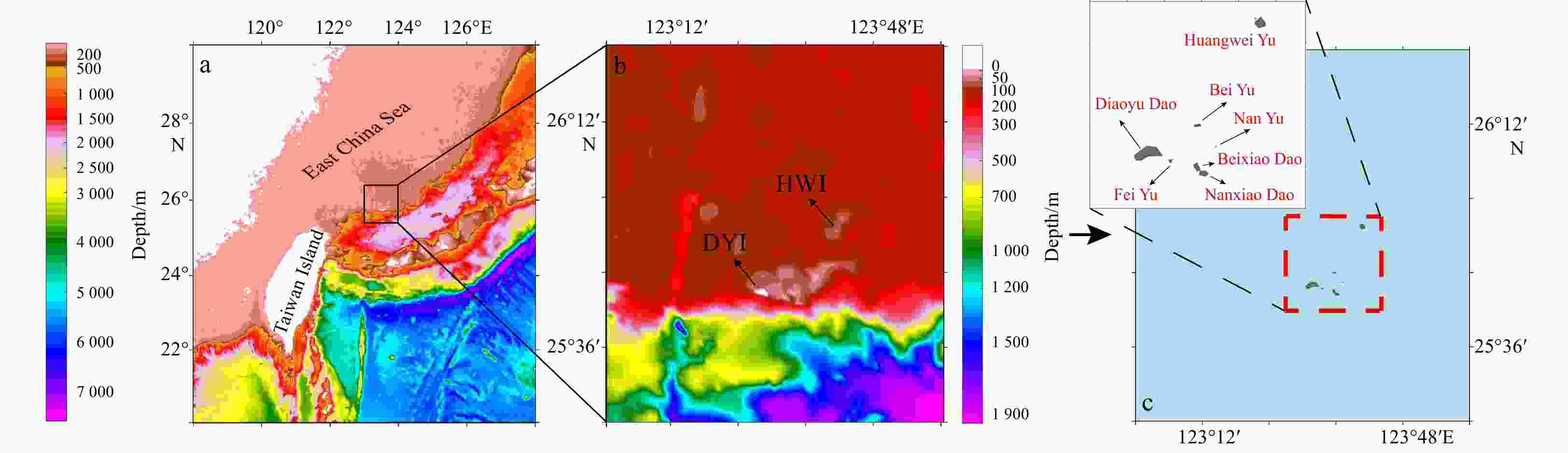
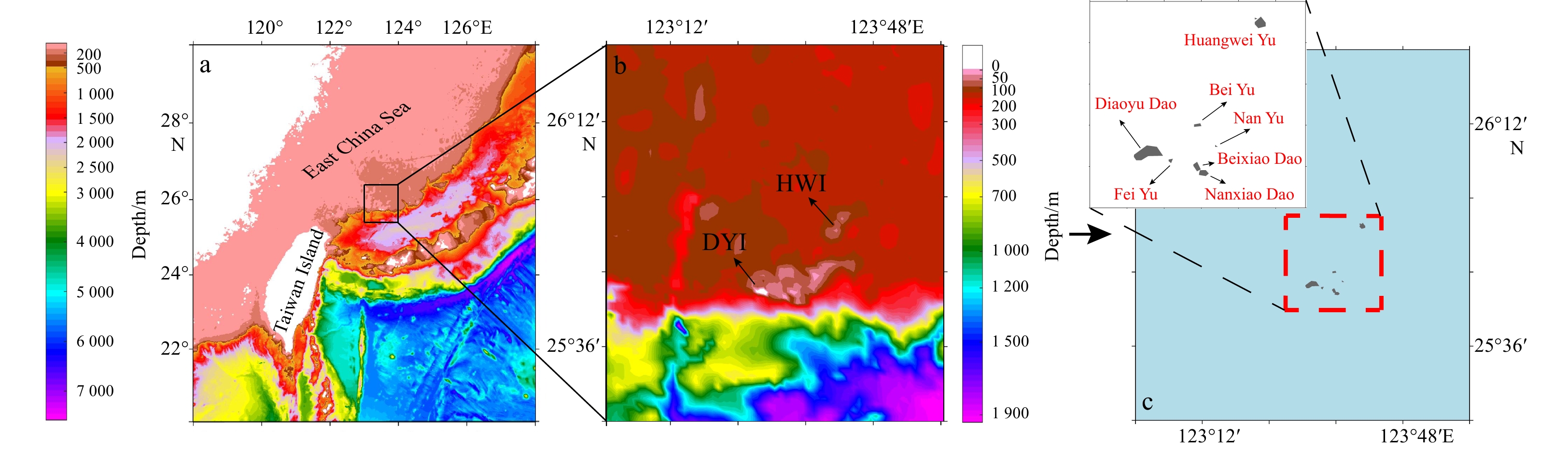
Figure 1. Location of Diaoyu Dao and its affiliated islands (a, c), and the topography of this study area (b). “DYI” in b is the abbreviation of Diaoyu Dao, “HWI” in b is Huangwei Yu.
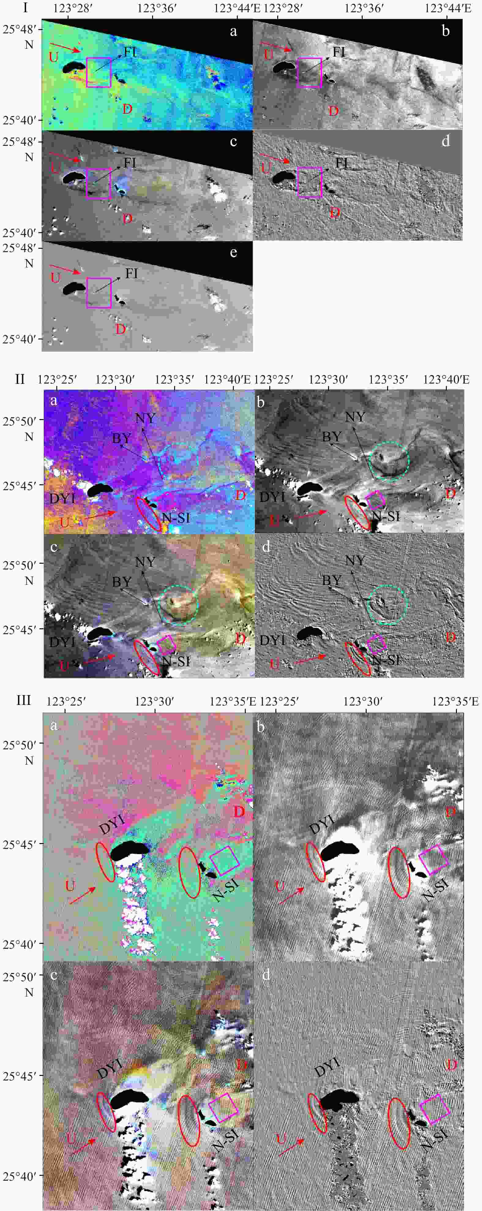
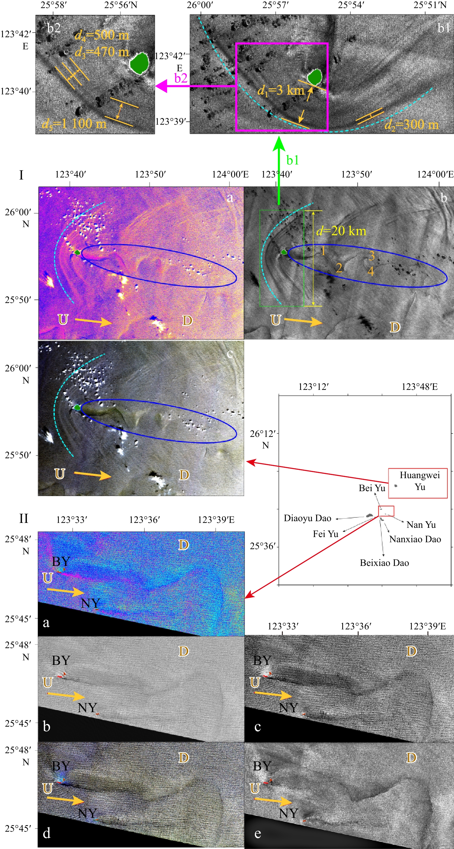
Figure 2. The change of sun glitter upstream and downstream of Diaoyu Dao retrieved by Shield-and-Velocity 1 (SAV1) from GF-6 Panchromatic and Multispectral Sensors (PMS) image on September 8, 2019 (I), GF-1 PMS1 image on July 31, 2019 (II) and GF-1 PMS2 image on August 25, 2016 (III). a. Classification; b. co-occurrence; c. median; d. SAV1; e. low-pass high-pass Fast Fourier Transform. U: upstream; D: downstream. Red arrow: the direction of local current; red ellipse: the westward shield of the islands; magenta square: the downstream shelter area; cyan circle: the eddy downstream. Black patches: Diaoyu Dao (DYI), Beixiao Dao and Nanxiao Dao (N-SI), Fei Yu (FI), Nan Yu (NY) and Bei Yu (BY).
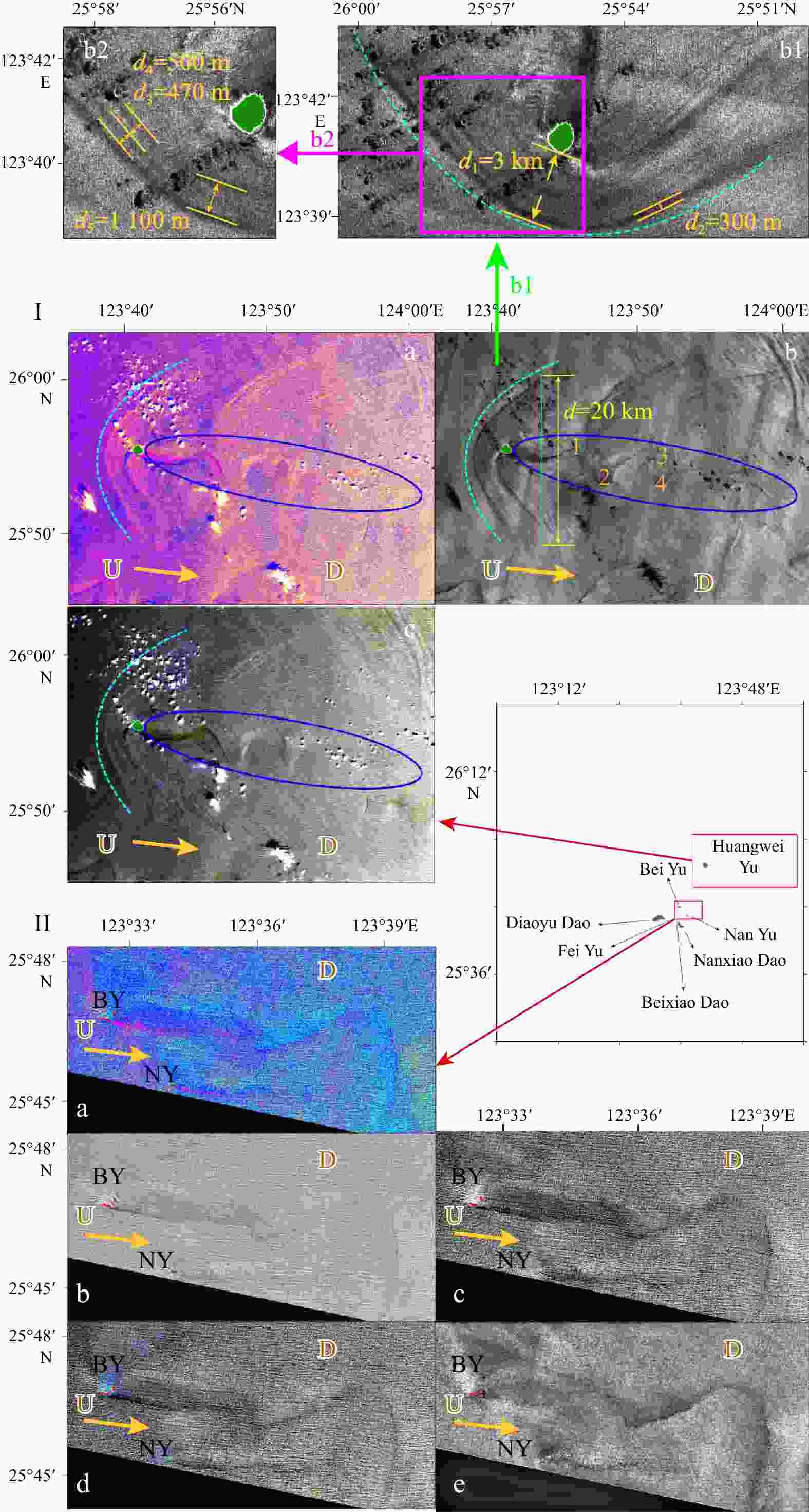
Figure 3. In I, sun glitter change upstream and downstream of Huangwei Yu retrieved from classification (a), Shield-and-Velocity 2 (SAV2) (b) and median (c). b rotates 90°counterclockwise to b-1. In II, sun glitter change in the downstream of Bei Yu and Nan Yu retrieved from classification (a), low-pass Fast Fourier Transform (b), co-occurrence (c), median (d) and SAV2 (e). They were both retrieved from GF-6 Panchromatic and Multispectral Sensors image on September 8, 2019. U: upstream; D: downstream. Yellow arrow: the direction of local current; cyan curve arc: the westward shield of the island; blue ellipse: the vortex downstream; green patch in I: Huangwei Yu (HWI); red and black marks in II: Bei Yu (BY) and Nan Yu (NY).
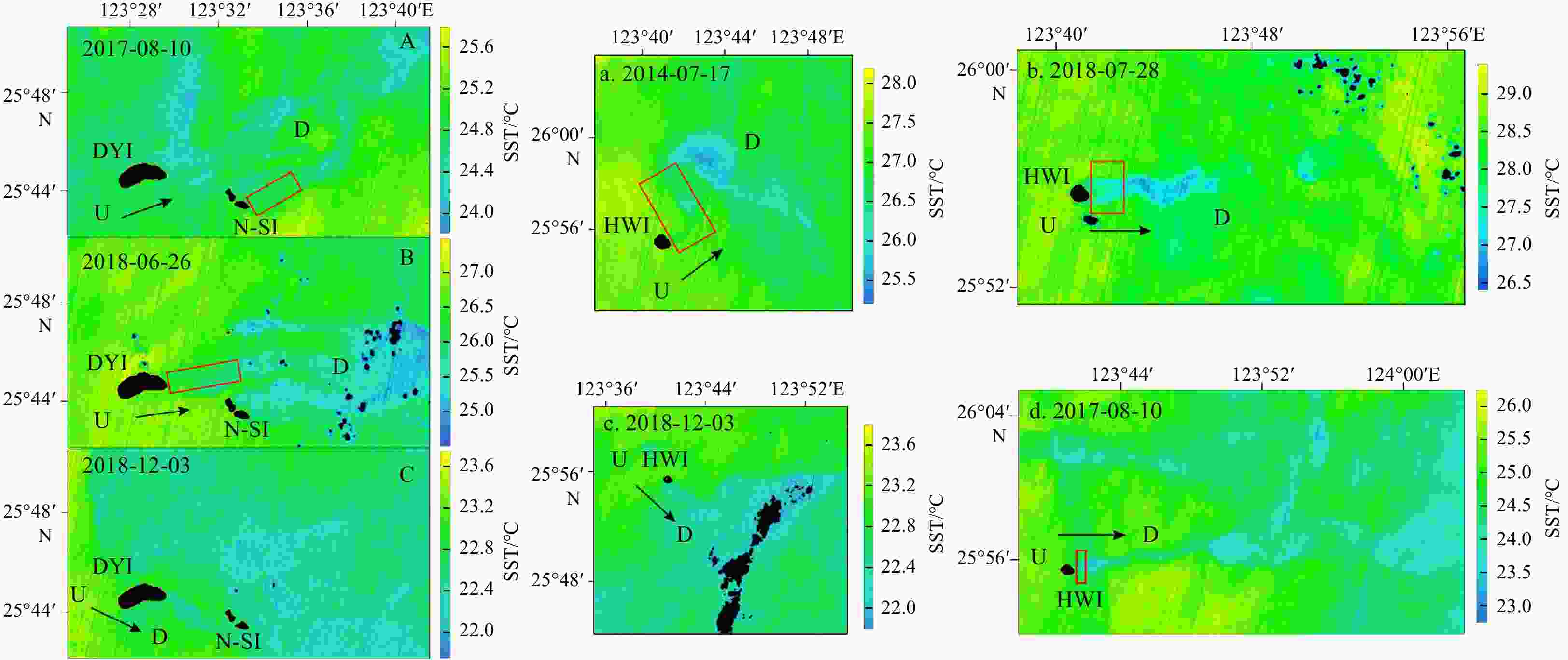
Figure 4. Sea surface temperature (SST) retrieved from Landsat-8 images. A, B and C show SST distribution near Diaoyu Dao (DYI), Beixiao Dao and Nanxiao Dao (N-SI); a, b, c and d show SST distribution near Huangwei Yu (HWI). U: upstream. D: downstream. Black arrow: the direction of local current; red square: the area in the downstream where SST reduction is not obvious.
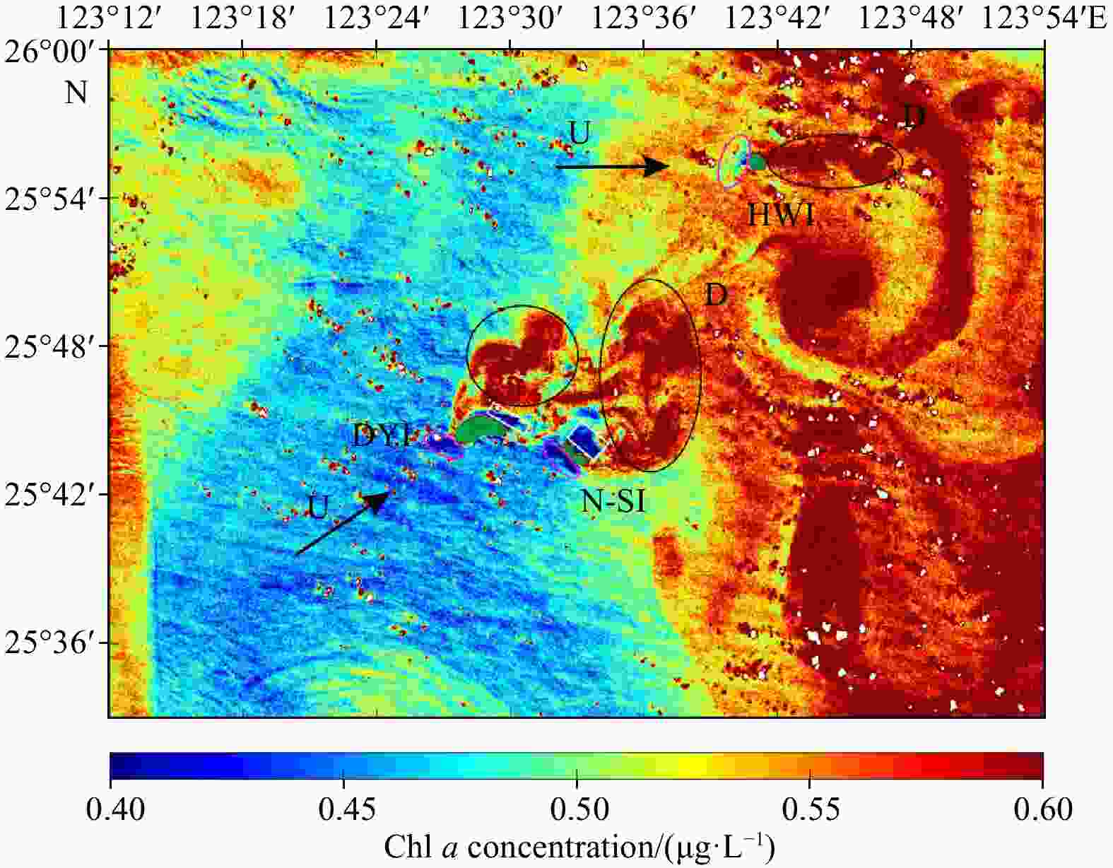
Figure 5. Chl a concentration around Diaoyu Dao and its affiliated islands retrieved from image of HY-1C Coastal Zone Imager on January 3, 2020. U: upstream; D: downstream. Black arrow: the direction of local current; magenta ellipse and white square: the low Chl a concentration area upstream and downstream the islands; black ellipse: the high Chl a concentration area downstream; green patches: Diaoyu Dao (DYI), Beixiao Dao and Nanxiao Dao (N-SI), and Huangwei Yu (HWI).
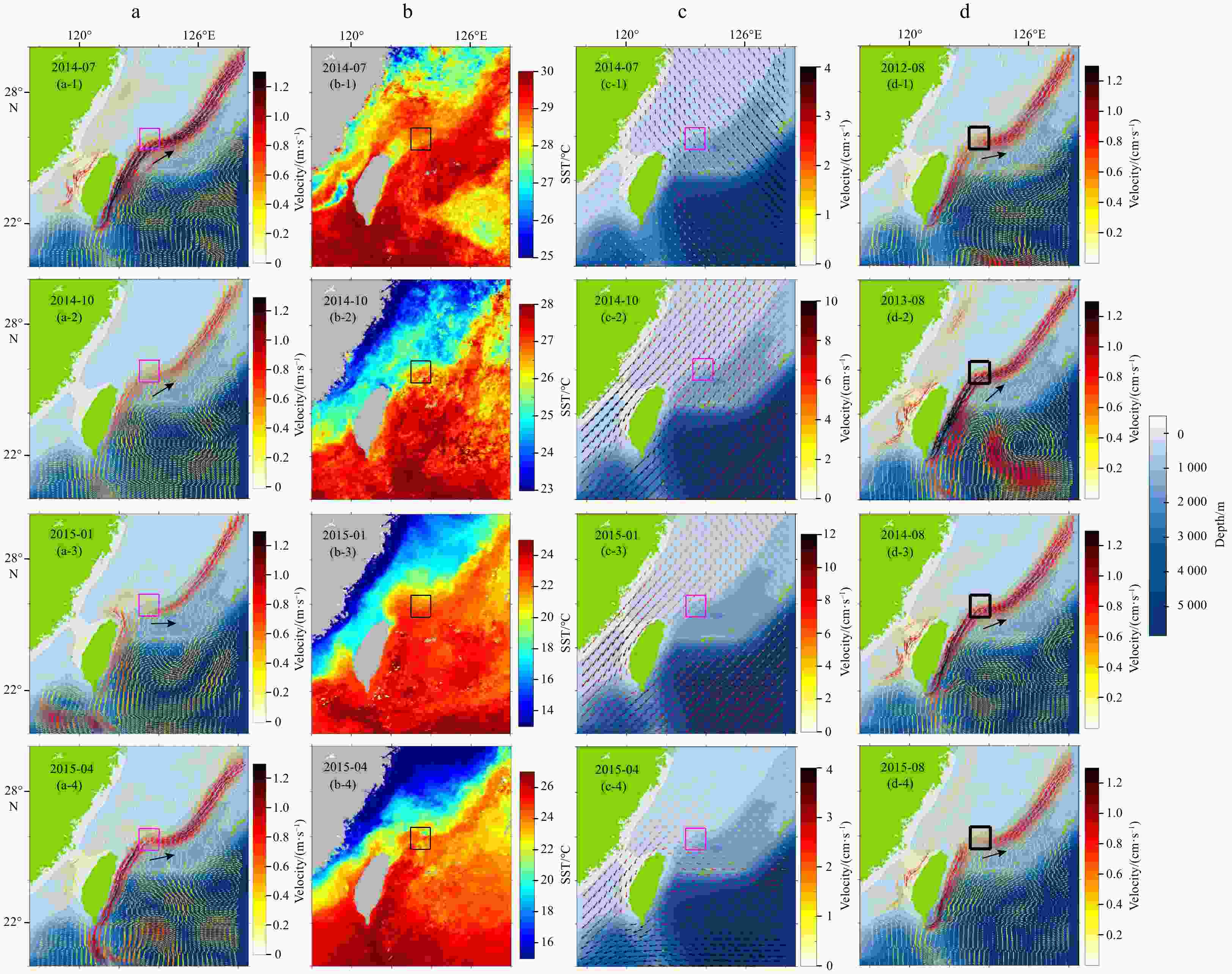
Figure 6. Monthly mean variability results from August 2012 to August 2015. a and d show sea surface current; b. sea surface temperature (SST); c. wind field. The current data depth is 6 m. Square box: the position of Diaoyu Dao and its affiliated islands; black arrow: the current direction in Diaoyu Dao and its affiliated islands area.
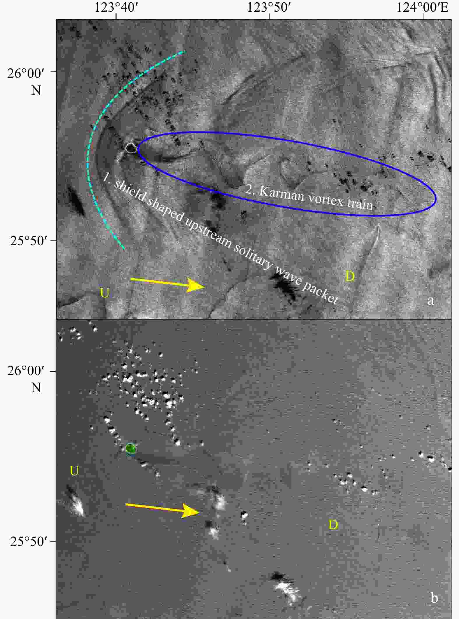
Figure 7. Sun glitter change upstream and downstream of Huangwei Yu retrieved from Shield-and-Velocity 2 (SAV2) method (a), the result of image fusion among panchromatic and multispectral bands (b). Data acquisition in September 8, 2019 from GF-6 PMS. U: upstream; D: downstream. Yellow arrow: the direction of local current; cyan curve arc: the westward shield of the island; blue ellipse: the vortex downstream; green patch: Huangwei Yu.
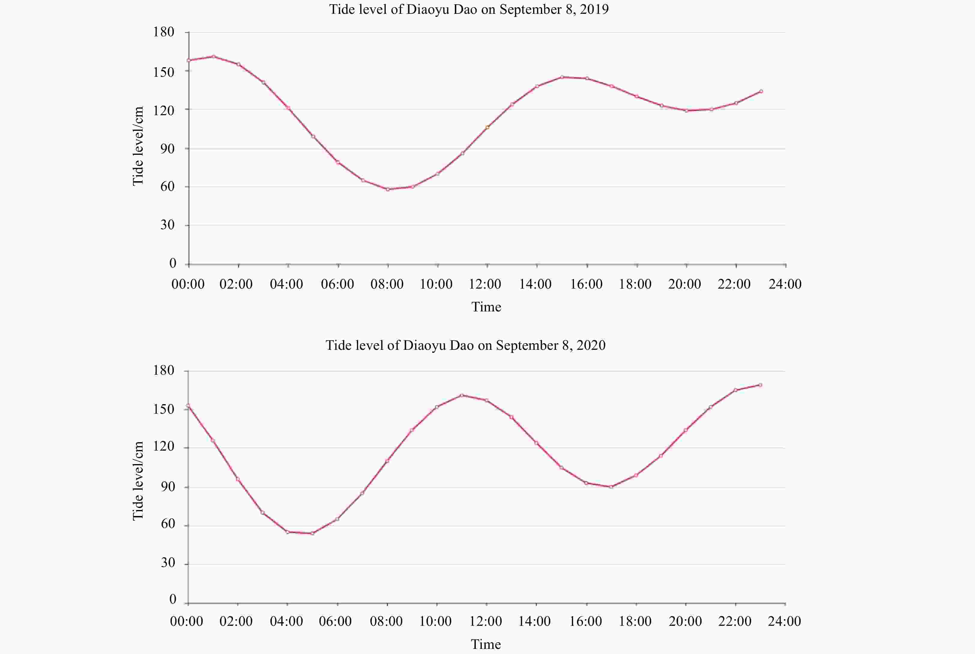
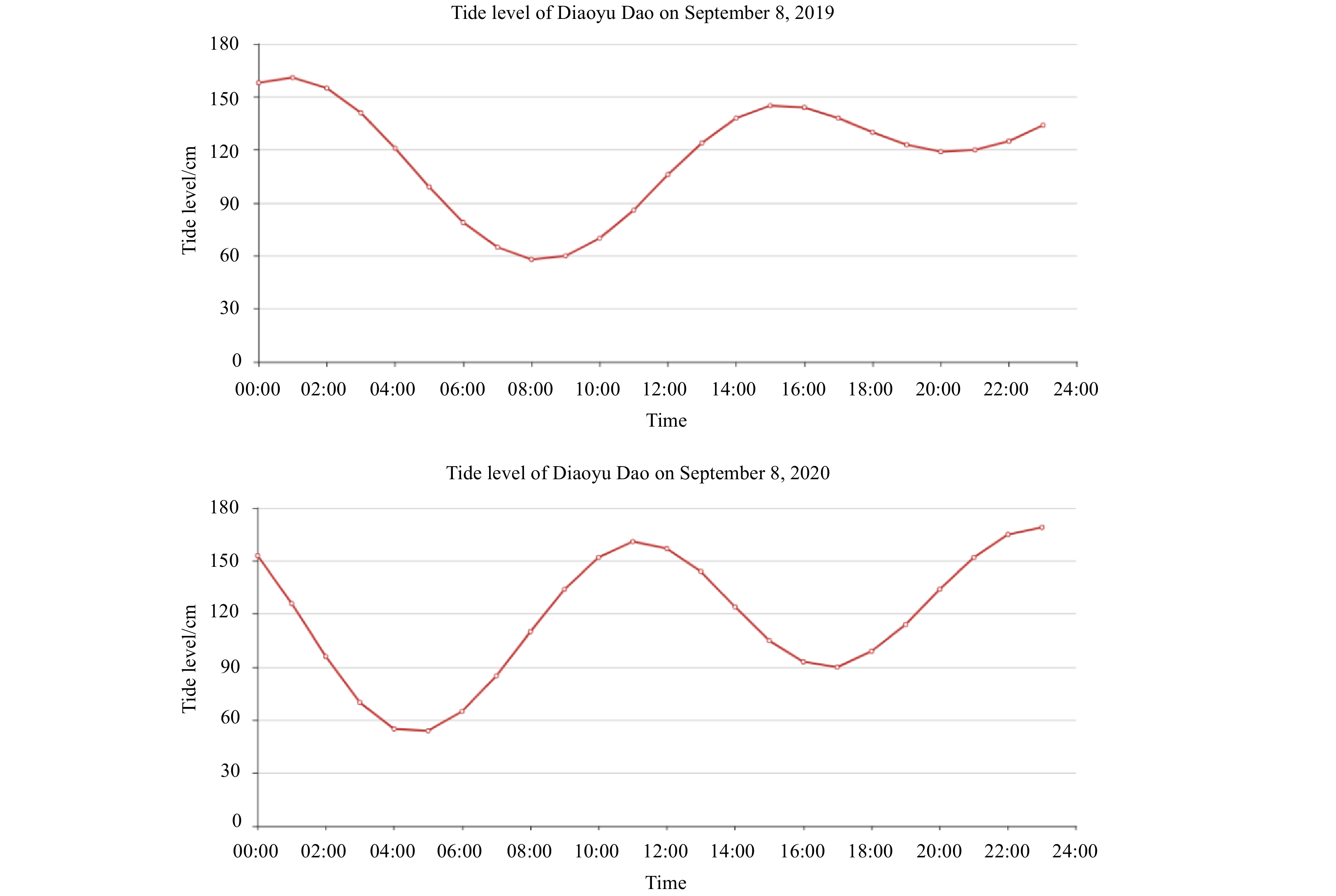
Figure 8. Tide level of Diaoyu Dao on September 8, 2019 and 2020 acquired from National Marine Data Center of China.

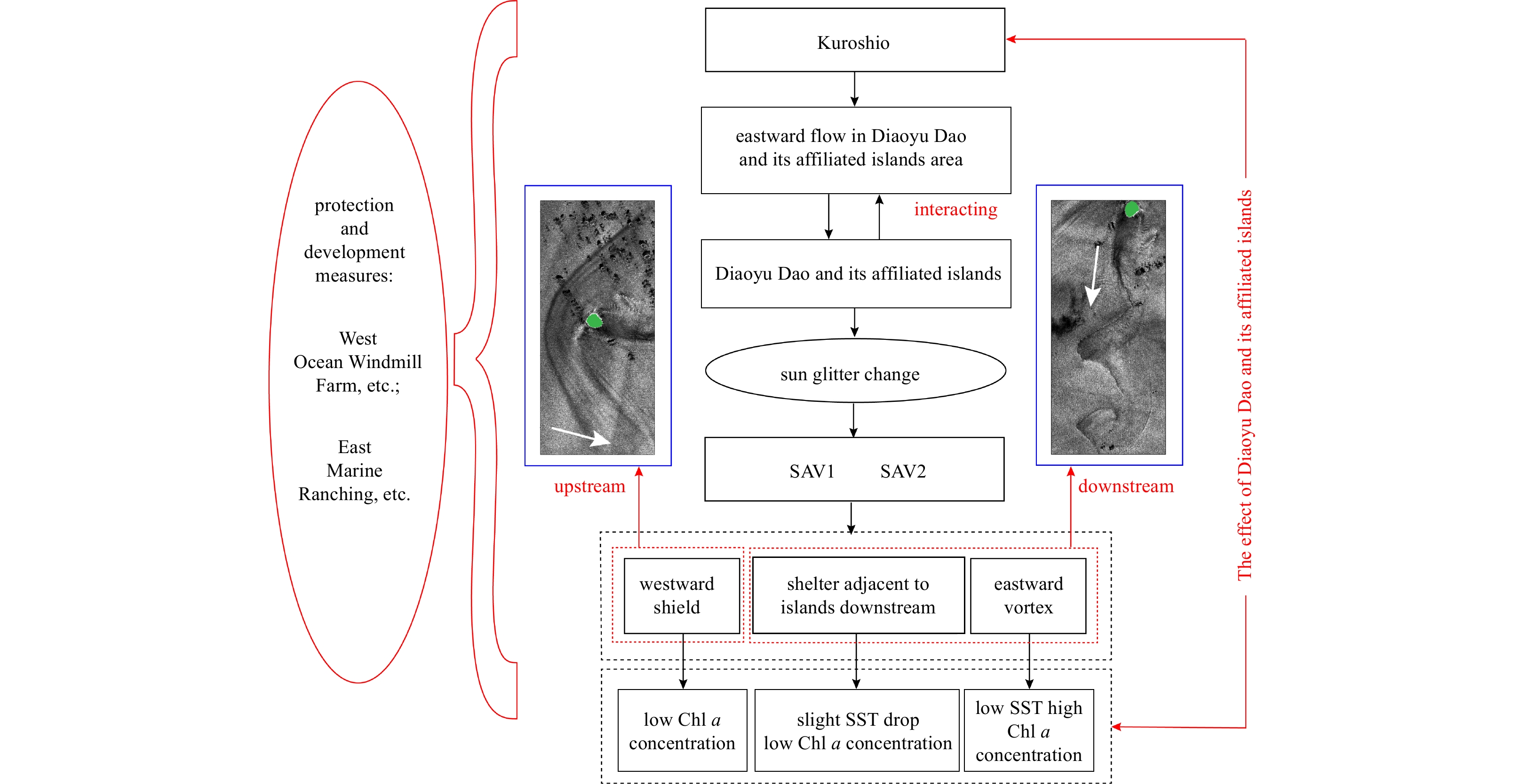
Figure 9. Graphical abstract illustrating the impact of Diaoyu Dao and its affiliated islands on the water environment nearby. Green patch: island; white arrow: flow direction. SAV: Shield and Vortex 1-2 (SAV1-2); SST: sea surface temperature.
Table 1. Details of sensors and satellite data
Sensor Band Wavelength/μm Resolution/m Date GF-6PMS Band1 (blue) 0.45−0.52 8 Sept. 8, 2019 Band2 (green) 0.52−0.60 8 Sept. 8, 2019 Band3 (red) 0.63−0.69 8 Sept. 8, 2019 Band4 (NIR) 0.76−0.90 8 Sept. 8, 2019 PAN 0.45−0.90 2 Sept. 8, 2019 GF-1PMS1/PMS2 Band1 (blue) 0.45−0.52 8 Aug. 25, 2016 Band2 (green) 0.52−0.59 8 Aug. 25, 2016 Band3 (red) 0.63−0.69 8 Aug. 25, 2016 Band4 (NIR) 0.77−0.89 2 Jul. 31, 2019 PAN 0.45−0.90 2 Jul. 31, 2019 Landsat-8 TIRS 100 Jul. 17, 2014 Band10 (TIR) 10.60−11.19 100 Aug. 10, 2017 10.60−11.19 100 Jun. 26, 2018 Band11 (TIR) 11.50−12.51 100 Jul. 28, 2018 11.50−12.51 100 Dec. 3, 2018 HY-1CCZI Band1 0.421−0.500 50 Oct. 3, 2020 Band2 0.517−0.598 50 Oct. 3, 2020 Band3 0.608−0.690 50 Oct. 3, 2020 Band4 0.761−0.891 50 Oct. 3, 2020 Note: PMS, Panchromatic and Multispectral Sensors; TIRS, Thermal Infrared Sensor; CZI, Coastal Zone Imager; NIR, near-infrared; PAN, panchromatic band.  下载: 导出CSV
Table 2. Details of current data
Data introduction Data acquisition time Seasonal variation summer: Jul. 2014; autumn: Oct. 2014; winter: Jan. 2015; spring: Apr. 2015 Inter-annual variation Aug. 2012; Aug. 2013; Aug. 2014; Aug. 2015
下载: 导出CSV
-
Aghav A S, Narkhede N S. 2017. Application-oriented approach to texture feature extraction using Grey Level Co-occurrence Matrix (GLCM). International Research Journal of Engineering and Technology, 4(5): 3498–3503 Aiazzi B, Baronti S, Lotti F, et al. 2009. A comparison between global and context-adaptive pansharpening of multispectral images. IEEE Geoscience and Remote Sensing Letters, 6(2): 302–306. doi: 10.1109/LGRS.2008.2012003 Akylas T R. 1984. On the excitation of long nonlinear water waves by a moving pressure distribution. Journal of Fluid Mechanics, 141: 455–466. doi: 10.1017/S0022112084000926 Alpers W. 1985. Theory of radar imaging of internal waves. Nature, 314(6008): 245–247. doi: 10.1038/314245a0 Anderson G P, Pukall B, Allred C L, et al. 1999. FLAASH and MODTRAN4: state-of-the-art atmospheric correction for hyperspectral data. In: Proceedings of 1999 IEEE Aerospace Conference. Snowmass: IEEE, 177–181 Arístegui J, Sangrá P, Hernández-León S, et al. 1994. Island-induced eddies in the Canary islands. Deep-Sea Research Part I: Oceanographic Research Papers, 41(10): 1509–1525. doi: 10.1016/0967-0637(94)90058-2 Assi G R S, Meneghini J R, Aranha J A P, et al. 2006. Experimental investigation of flow-induced vibration interference between two circular cylinders. Journal of Fluids and Structures, 22(6–7): 819–827 Babin S M, Carton J A, Dickey T D, et al. 2004. Satellite evidence of hurricane-induced phytoplankton blooms in an oceanic desert. Journal of Geophysical Research, 109(C3): C03043 Baines P G. 1977. Upstream influence and Long’s model in stratified flows. Journal of Fluid Mechanics, 82(1): 147–159. doi: 10.1017/S0022112077000573 Bao Qing, Wu Xiaofei, Li Jinxiao, et al. 2019. Outlook for El Niño and the Indian Ocean Dipole in autumn-winter 2018−2019. Chinese Science Bulletin, 64(1): 73–78. doi: 10.1360/N972018-00913 Bernardo N, Alcântara E, Watanabe F, et al. 2018. Glint removal assessment to estimate the remote sensing reflectance in inland waters with widely differing optical properties. Remote Sensing, 10(10): 1655. doi: 10.3390/rs10101655 Bréon F M, Deschamps P Y. 1993. Optical and physical parameter retrieval from POLDER measurements over the ocean using an analytical model. Remote Sensing of Environment, 43(2): 193–207. doi: 10.1016/0034-4257(93)90008-L Cai Lina, Tang Danling, Levy G, et al. 2016. Remote sensing of the impacts of construction in coastal waters on suspended particulate matter concentration—the case of the Yangtze River delta, China. International Journal of Remote Sensing, 37(9): 2132–2147. doi: 10.1080/01431161.2015.1121302 Cai Lina, Zhou Minrui, Liu Jianqiang, et al. 2020. HY-1C observations of the impacts of islands on suspended sediment distribution in Zhoushan Coastal Waters, China. Remote Sensing, 12(11): 1766. doi: 10.3390/rs12111766 Caldeira R M A, Groom S, Miller P, et al. 2002. Sea-surface signatures of the island mass effect phenomena around Madeira Island, Northeast Atlantic. Remote Sensing of Environment, 80(2): 336–360. doi: 10.1016/S0034-4257(01)00316-9 Caldeira R M A, Marchesiello P, Nezlin N P, et al. 2005. Island wakes in the Southern California bight. Journal of Geophysical Research, 110(C11): C11012. doi: 10.1029/2004JC002675 Cardoso C, Caldeira R M A, Relvas P, et al. 2020. Islands as eddy transformation and generation hotspots: Cabo Verde case study. Progress in Oceanography, 184: 102271. doi: 10.1016/j.pocean.2020.102271 Carmo B S, Sherwin S J, Bearman P W, et al. 2011. Flow-induced vibration of a circular cylinder subjected to wake interference at low Reynolds number. Journal of Fluids and Structures, 27(4): 503–522. doi: 10.1016/j.jfluidstructs.2011.04.003 Carr J R, de Miranda F P. 1998. The semivariogram in comparison to the co-occurrence matrix for classification of image texture. IEEE Transactions on Geoscience and Remote Sensing, 36(6): 1945–1952. doi: 10.1109/36.729366 Chang Ming-Huei, Jan Sen, Liu Chih-Lun, et al. 2019. Observations of island wakes at high rossby numbers: evolution of submesoscale vortices and free shear layers. Journal of Physical Oceanography, 49(11): 2997–3016. doi: 10.1175/JPO-D-19-0035.1 Chao S Y. 1990. Circulation of the East China Sea, a numerical study. Journal of Oceanography, 46(6): 273–295. doi: 10.1007/BF02123503 Chen Chen-Tung Arthur, Ruo R, Paid S C, et al. 1995. Exchange of water masses between the East China Sea and the Kuroshio off northeastern Taiwan. Continental Shelf Research, 15(1): 19–39. doi: 10.1016/0278-4343(93)E0001-O Chen Shengbo, Useya J, Mugiyo H. 2020. Decision-level fusion of Sentinel-1 SAR and Landsat 8 OLI texture features for crop discrimination and classification: case of Masvingo, Zimbabwe. Heliyon, 6(11): e05358. doi: 10.1016/j.heliyon.2020.e05358 Chen Qi, Yu Ruihong, Hao Yanling, et al. 2018. A new method for mapping aquatic vegetation especially underwater vegetation in lake ulansuhai using GF-1 satellite data. Remote Sensing, 10(8): 1279. doi: 10.3390/rs10081279 Chern Ching-Sheng, Wang Joe. 1989. On the water masses at northern offshore area of Taiwan. Acta Oceanographical Taiwanica, 22: 14–32 Choi Y C, Kim J S. 2008. Distribution of rhysico-chemical characteristics on the development of marine ranching program in the Chagwi-Do Coastal Waters, Jeju Island. Journal of the Korean Society for Marine Environment & Energy, 11(2): 105–112 Chu Ruijian, Richard N, Fernandez-Maloigne C, et al. 2019. Relative spectral difference occurrence matrix: a metrological spectral-spatial feature for hyperspectral texture analysis. Color and Imaging Conference, 27: art00069 Chuang Wen-Ssn, Li Hsien-Wen, Tang T Y, et al. 1993. Observations of the countercurrent on the inshore side of the Kuroshio northeast of Taiwan. Journal of Oceanography, 49(5): 581–592. doi: 10.1007/BF02237464 Coutis P F, Middleton J H. 2002. The physical and biological impact of a small island wake in the deep ocean. Deep-Sea Research Part I: Oceanographic Research Papers, 49(8): 1341–1361. doi: 10.1016/S0967-0637(02)00029-8 Cox C, Munk W. 1954. Measurement of the roughness of the sea surface from photographs of the sun’s glitter. Journal of the Optical Society of America, 44(11): 838–850. doi: 10.1364/JOSA.44.000838 Dong Changming, McWilliams J C. 2007. A numerical study of island wakes in the Southern California Bight. Continental Shelf Research, 27(6): 1233–1248 Eckermann S D, Preusse P. 1999. Global measurements of stratospheric mountain waves from space. Science, 286(5444): 1534–1537. doi: 10.1126/science.286.5444.1534 Ehlers M. 2008. Multi-image fusion in remote sensing: spatial enhancement vs. spectral characteristics preservation. In: Proceedings of the 4th International Symposium on Visual Computing. Las Vegas: Springer, 75–84 Eliassen A. 1980. Balanced motion of a stratified, rotating fluid induced by bottom topography. Tellus, 32(6): 537–547. doi: 10.3402/tellusa.v32i6.10607 Fu Lee-Lueng, Holt B. 1983. Some examples of detection of oceanic mesoscale eddies by the SEASAT synthetic-aperture radar. Journal of Geophysical Research, 88(C3): 1844–1852. doi: 10.1029/JC088iC03p01844 Gao Wenjun, Nelias D, Liu Zhenxia, et al. 2018. Numerical investigation of flow around one finite circular cylinder with two free ends. Ocean Engineering, 156: 373–380. doi: 10.1016/j.oceaneng.2018.03.020 Gerrard J H. 1966. The mechanics of the formation region of vortices behind bluff bodies. Journal of Fluid Mechanics, 25(2): 401–413. doi: 10.1017/S0022112066001721 Gonzalez R C, Woods R E. 1981. Digital image processing. IEEE Transactions on Pattern Analysis and Machine Intelligence, 3(2): 242–243 Gordon H R. 1997. Atmospheric correction of ocean color imagery in the Earth Observing System era. Journal of Geophysical Research, 102(D14): 17081–17106. doi: 10.1029/96JD02443 Gordon H R, Wang Menghua. 1992. Surface-roughness considerations for atmospheric correction of ocean color sensors. 1: the Rayleigh-scattering component. Applied Optics, 31(21): 4247–4260. doi: 10.1364/AO.31.004247 Guo Xinyu, Yanagi T. 1998. Three-dimensional structure of tidal current in the East China Sea and the Yellow Sea. Journal of Oceanography, 54(6): 651–668. doi: 10.1007/BF02823285 Hamner W M, Hauri I R. 1981. Effects of island mass: water flow and plankton pattern around a reef in the Great Barrier Reef Lagoon, Australia. Limnology and Oceanography, 26(6): 1084–1102. doi: 10.4319/lo.1981.26.6.1084 Han Zhaolong, Zhou Dai, Malla A, et al. 2018. Wake-induced vibration interference between a fixed square cylinder and a 2-DOF downstream square cylinder at low Reynolds numbers. Ocean Engineering, 164: 698–711. doi: 10.1016/j.oceaneng.2018.07.007 Haralick R M. 1979. Statistical and structural approaches to texture. Proceedings of the IEEE, 67(5): 786–804. doi: 10.1109/PROC.1979.11328 Haralick R M, Shanmugam K, Dinstein I. 1973. Textural features for image classification. IEEE Transactions on Systems, Man, and Cybernetics, SMC-3(6): 610–621 He Youhai, White W B. 1988. Interannual variability in the structure of the Kuroshio front along the western boundary of the North Pacific Ocean associated with the 1982 ENSO event. GeoJournal, 16(1): 53–63. doi: 10.1007/BF02626372 Hochberg E J, Andrefouet S, Tyler M R. 2003. Sea surface correction of high spatial resolution Ikonos images to improve bottom mapping in near-shore environments. IEEE Transactions on Geoscience and Remote Sensing, 41(7): 1724–1729. doi: 10.1109/TGRS.2003.815408 Hsu Po-Chun, Chang Ming-Huei, Lin Chen-Chih, et al. 2017. Investigation of the island-induced ocean vortex train of the Kuroshio Current using satellite imagery. Remote Sensing of Environment, 193: 54–64. doi: 10.1016/j.rse.2017.02.025 Hsu Po-Chun, Cheng Kai-Ho, Jan Sen, et al. 2019. Vertical structure and surface patterns of Green Island wakes induced by the Kuroshio. Deep-Sea Research Part I: Oceanographic Research Papers, 143: 1–16. doi: 10.1016/j.dsr.2018.11.002 Hu Shineng, Fedorov A V. 2019. The extreme El Niño of 2015−2016: the role of westerly and easterly wind bursts, and preconditioning by the failed 2014 event. Climate Dynamics, 52(12): 7339–7357. doi: 10.1007/s00382-017-3531-2 Hu Dunxin, Wu Lixin, Cai Wenju, et al. 2015. Pacific western boundary currents and their roles in climate. Nature, 522(7556): 299–308. doi: 10.1038/nature14504 Huang Ting-Hsuan, Chen Chen-Tung Arthur, Zhang Wenzhou, et al. 2015. Varying intensity of Kuroshio intrusion into Southeast Taiwan Strait during ENSO events. Continental Shelf Research, 103: 79–87. doi: 10.1016/j.csr.2015.04.021 Huang Shuyi, Liu Jianqiang, Cai Lina, et al. 2020. Satellites HY-1C and landsat 8 combined to observe the influence of bridge on sea surface temperature and suspended sediment concentration in Hangzhou Bay, China. Water, 12(9): 2595. doi: 10.3390/w12092595 Hwang Cheinway, Kao Ricky. 2002. TOPEX/POSEIDON-derived space-time variations of the Kuroshio Current: applications of a gravimetric geoid and wavelet analysis. Geophysical Journal International, 151(3): 835–847. doi: 10.1046/j.1365-246X.2002.01811.x Jackson C R, Alpers W. 2010. The role of the critical angle in brightness reversals on sunglint images of the sea surface. Journal of Geophysical Research, 115(C9): C09019 Jebali H, Richard N, Chatoux H, et al. 2018. Relocated colour contrast occurrence matrix and adapted similarity measure for colour texture retrieval. In: Proceedings of the 19th International Conference on Advanced Concepts for Intelligent Vision Systems. Poitiers: Springer, 609–619 Jia Kun, Liang Shunlin, Gu Xingfa, et al. 2016. Fractional vegetation cover estimation algorithm for Chinese GF-1 wide field view data. Remote Sensing of Environment, 177: 184–191. doi: 10.1016/j.rse.2016.02.019 Kay S, Hedley J D, Lavender S. 2009. Sun glint correction of high and low spatial resolution images of aquatic scenes: a review of methods for visible and near-infrared wavelengths. Remote Sensing, 1(4): 697–730. doi: 10.3390/rs1040697 Kay S, Hedley J, Lavender S. 2013. Sun glint estimation in marine satellite images: a comparison of results from calculation and radiative transfer modeling. Applied Optics, 52(23): 5631–5639. doi: 10.1364/AO.52.005631 Kondo M. 1985. Oceanographic investigations of fishing grounds in the East China Sea and the Yellow Sea. I. Characteristics of the mean temperature and salinity distributions measured at 50 m and near the bottom. Bulletin of Seikai National Fisheries Research Institute, 62: 19–66 Koumoutsakos P, Leonard A. 1995. High-resolution simulations of the flow around an impulsively started cylinder using vortex methods. Journal of Fluid Mechanics, 296: 1–38. doi: 10.1017/S0022112095002059 Kutser T, Vahtmäe E, Praks J. 2009. A sun glint correction method for hyperspectral imagery containing areas with non-negligible water leaving NIR signal. Remote Sensing of Environment, 113(10): 2267–2274. doi: 10.1016/j.rse.2009.06.016 Lamura A, Gompper G. 2002. Numerical study of the flow around a cylinder using multi-particle collision dynamics. The European Physical Journal E, 9(5): 477–485 Larock B E. 1996. Topographic effects in stratified flows. Eos, Transactions American Geophysical Union, 77(16): 151 Larsen L H, Cannon G A, Choi B H. 1985. East China Sea tide currents. Continental Shelf Research, 4(1–2): 77–103 Levine A F Z, McPhaden M J. 2016. How the July 2014 easterly wind burst gave the 2015–2016 El Niño a head start. Geophysical Research Letters, 43(12): 6503–6510. doi: 10.1002/2016GL069204 Li Xiaofeng, Dong Changming, Clemente-Colón P, et al. 2004. Synthetic aperture radar observation of the sea surface imprints of upstream atmospheric solitons generated by flow impeded by an island. Journal of Geophysical Research, 109(C2): C02016 Li Qian, Li Guangxue, Chen Minte, et al. 2020. New insights into Kuroshio current evolution since the last deglaciation based on paired organic paleothermometers from the middle Okinawa Trough. Paleoceanography and Paleoclimatology, 35(12): e2020PA004140 Li Guangxue, Wei Helong, Yue Shuhong, et al. 1998. Sedimentation in the Yellow River delta, part II: suspended sediment dispersal and deposition on the subaqueous delta. Marine Geology, 149(1–4): 113–131 Liu Zhiqiang, Gan Jianping, Hu Jianyu, et al. 2021. Progress on circulation dynamics in the East China Sea and southern Yellow Sea: origination, pathways, and destinations of shelf currents. Progress in Oceanography, 193: 102553. doi: 10.1016/j.pocean.2021.102553 Liu Kon-Kee, Gong Gwo-Ching, Lin Saulwood, et al. 1992. The year-round upwelling at the shelf break near the northern tip of Taiwan as evidenced by chemical hydrography. Terrestrial, Atmospheric and Oceanic Sciences, 3(3): 243–276 Liu Guo, Wang Yizhe, Guo Li, et al. 2020. Research on fusion of GF-6 imagery and quality evaluation. E3S Web of Conferences, 165: 03016. doi: 10.1051/e3sconf/202016503016 Lu Yingcheng, Sun Shaojie, Zhang Minwei, et al. 2016. Refinement of the critical angle calculation for the contrast reversal of oil slicks under sunglint. Journal of Geophysical Research, 121(1): 148–161. doi: 10.1002/2015JC011001 Lyzenga D R, Malinas N P, Tanis F J. 2006. Multispectral bathymetry using a simple physically based algorithm. IEEE Transactions on Geoscience and Remote Sensing, 44(8): 2251–2259. doi: 10.1109/TGRS.2006.872909 Mao Kebiao, Qin Zhihao, Shi Jiancheng, et al. 2005. A practical split-window algorithm for retrieving land-surface temperature from MODIS data. International Journal of Remote Sensing, 26(15): 3181–3204. doi: 10.1080/01431160500044713 Marceau D J, Howarth P J, Dubois J M, et al. 1990. Evaluation of the grey-level co-occurrence matrix method for land-cover classification using SPOT imagery. IEEE Transactions on Geoscience and Remote Sensing, 28(4): 513–519. doi: 10.1109/TGRS.1990.572937 Materka A, Strzelecki M. 1998. Texture analysis methods—a review. Brussels: Technical University of Lodz, Institute of Electronics Matthews J. 2005. Stereo observation of lakes and coastal zones using ASTER imagery. Remote Sensing of Environment, 99(1–2): 16–30 Melsheimer C, Keong K L. 2022. Sun glitter in spot images and the visibility of oceanic phenomena. In: Proceedings of the 22nd Asian Conference on Remote Sensing. Singapore: Center for Remote Imaging, Sensing and Processing, National University of Singapore Morel A, Gentili B. 1993. Diffuse reflectance of oceanic waters. II. Bidirectional aspects. Applied Optics, 32(33): 6864–6879. doi: 10.1364/AO.32.006864 Morel A, Gentili B. 1996. Diffuse reflectance of oceanic waters. III. Implication of bidirectionality for the remote-sensing problem. Applied Optics, 35(24): 4850–4862. doi: 10.1364/AO.35.004850 Nematollahi A, Tachie M F. 2018. Time-resolved PIV measurement of influence of upstream roughness on separated and reattached turbulent flows over a forward-facing step. AIP Advances, 8(10): 105110. doi: 10.1063/1.5063455 Nikam B R, Ibragimov F, Chouksey A, et al. 2016. Retrieval of land surface temperature from Landsat 8 TIRS for the command area of Mula irrigation project. Environmental Earth Sciences, 75(16): 1169. doi: 10.1007/s12665-016-5952-3 Oh T Y, Cha H K, Chang D S, et al. 2010. Seasonal variation and species composition of fishes communities in artificial reef unit at marine ranching area in the coastal waters off Jeju Island, Korea. Journal of the Korean Society of Fisheries and Ocean Technology, 46(2): 139–147. doi: 10.3796/KSFT.2010.46.2.139 Oka E, Kawabe M. 1998. Characteristics of variations of water properties and density structure around the Kuroshio in the East China Sea. Journal of Oceanography, 54(6): 605–617. doi: 10.1007/BF02823281 Oliveira P J. 2001. Method for time-dependent simulations of viscoelastic flows: vortex shedding behind cylinder. Journal of Non-Newtonian Fluid Mechanics, 101(1–3): 113–137 Onea F, Rusu L. 2015. Coastal impact of a hybrid marine farm operating close to the Sardinia Island. In: Proceedings of OCEANS 2015. Genova: IEEE, 1–7 Pacifici F, Longbotham N, Emery W J. 2014. The importance of physical quantities for the analysis of multitemporal and multiangular optical very high spatial resolution images. IEEE Transactions on Geoscience and Remote Sensing, 52(10): 6241–6256. doi: 10.1109/TGRS.2013.2295819 Pakdel P, McKinley G H. 1996. Elastic instability and curved streamlines. Physical Review Letters, 77(12): 2459–2462. doi: 10.1103/PhysRevLett.77.2459 Patoine A, Warn T. 1982. The interaction of long, quasi-stationary baroclinic waves with topography. Journal of the Atmospheric Sciences, 39(5): 1018–1025. doi: 10.1175/1520-0469(1982)039<1018:TIOLQS>2.0.CO;2 Pattiaratchi C, James A, Collins M. 1987. Island wakes and headland eddies: a comparison between remotely sensed data and laboratory experiments. Journal of Geophysical Research, 92(C1): 783–794. doi: 10.1029/JC092iC01p00783 Peng Jida, Zhang Chungui. 2019. Remote sensing monitoring of vegetation coverage by GF-1 satellite: a case study in Xiamen City. Remote Sensing for Land & Resources (in Chinese), 31(4): 137–142 Petersen J K, Malm T. 2006. Offshore windmill farms: threats to or possibilities for the marine environment. Ambio: A Journal of the Human Environment, 35(2): 75–80. doi: 10.1579/0044-7447(2006)35[75:OWFTTO]2.0.CO;2 Puissant A, Hirsch J, Weber C. 2005. The utility of texture analysis to improve per-pixel classification for high to very high spatial resolution imagery. International Journal of Remote Sensing, 26(4): 733–745. doi: 10.1080/01431160512331316838 Punt M J, Groeneveld R A, van Ierland E C, et al. 2009. Spatial planning of offshore wind farms: a windfall to marine environmental protection?. Ecological Economics, 69(1): 93–103. doi: 10.1016/j.ecolecon.2009.07.013 Qin Boyang, Salipante P F, Hudson S D, et al. 2019. Upstream vortex and elastic wave in the viscoelastic flow around a confined cylinder. Journal of Fluid Mechanics, 864: R2. doi: 10.1017/jfm.2019.73 Qiu Bo, Imasato N. 1990. A numerical study on the formation of the Kuroshio Counter Current and the Kuroshio Branch Current in the East China Sea. Continental Shelf Research, 10(2): 165–184. doi: 10.1016/0278-4343(90)90028-K Qiu Bo, Joyce T M. 1992. Interannual variability in the mid- and low-latitude western North Pacific. Journal of Physical Oceanography, 22(9): 1062–1079. doi: 10.1175/1520-0485(1992)022<1062:IVITMA>2.0.CO;2 Qiu Bo, Lukas R. 1996. Seasonal and interannual variability of the North Equatorial Current, the Mindanao Current, and the Kuroshio along the Pacific western boundary. Journal of Geophysical Research, 101(C5): 12315–12330. doi: 10.1029/95JC03204 Rascle N, Molemaker J, Marié L, et al. 2017. Intense deformation field at oceanic front inferred from directional sea surface roughness observations. Geophysical Research Letters, 44(11): 5599–5608. doi: 10.1002/2017GL073473 Rascle N, Nouguier F, Chapron B, et al. 2016. Surface roughness changes by finescale current gradients: properties at multiple azimuth view angles. Journal of Physical Oceanography, 46(12): 3681–3694. doi: 10.1175/JPO-D-15-0141.1 Ren Baiyang, Wen Qiang, Zhou Huizhen, et al. 2018. Extraction and analysis of major autumn crops in JINGXIAN county based on multi-temporal GF-1 remote sensing image and object-oriented. International Archives of the Photogrammetry, Remote Sensing and Spatial Information Sciences, XLII-3: 1473–1480 Roy S K, Chanda B, Chaudhuri B B, et al. 2018. Local directional ZigZag pattern: a rotation invariant descriptor for texture classification. Pattern Recognition Letters, 108: 23–30. doi: 10.1016/j.patrec.2018.02.027 Şahin Ç, Atalık K. 2019. Comparison of inelastic and elastic non-Newtonian effects on the flow around a circular cylinder in periodic vortex shedding. Journal of Non-Newtonian Fluid Mechanics, 263: 1–14. doi: 10.1016/j.jnnfm.2018.11.004 Schott J, Gerace A, Brown S, et al. 2012. Simulation of image performance characteristics of the landsat data continuity mission (LDCM) thermal infrared sensor (TIRS). Remote Sensing, 4(8): 2477–2491. doi: 10.3390/rs4082477 Shabat A M, Tapamo J R. 2017. A comparative study of the use of local directional pattern for texture-based informal settlement classification. Journal of Applied Research and Technology, 15(3): 250–258. doi: 10.1016/j.jart.2016.12.009 Shen S S. 1993. A Course on Nonlinear Waves. Dordrecht: Kluwer Academic Sheremet V A. 2010. Hysteresis of a western boundary current leaping across a gap. Journal of Physical Oceanography, 31(5): 1247–1259 Strykowski P J, Sreenivasan K R. 1990. On the formation and suppression of vortex ‘shedding’ at low Reynolds numbers. Journal of Fluid Mechanics, 218: 71–107. doi: 10.1017/S0022112090000933 Sturm B. 1980. The atmospheric correction of remotely sensed data and the quantitative determination of suspended matter in marine water surface layers. In: Cracknell A P, ed. Remote Sensing in Oceanography and Hydrology. Chichester: Ellis Horwood Sun Xiangping, Wang Jin, Chen Ronghua, et al. 2011. Directional gaussian filter-based LBP descriptor for textural image classification. Procedia Engineering, 15: 1771–1779. doi: 10.1016/j.proeng.2011.08.330 Tang T Y, Hsueh Y, Yang Y J, et al. 1999. Continental slope flow northeast of Taiwan. Journal of Physical Oceanography, 29(6): 1353–1362. doi: 10.1175/1520-0485(1999)029<1353:CSFNOT>2.0.CO;2 Tang T Y, Tai J H, Yang Y J. 2000. The flow pattern north of Taiwan and the migration of the Kuroshio. Continental Shelf Research, 20(4–5): 349–371 Teinturier S, Stegner A, Didelle H, et al. 2010. Small-scale instabilities of an island wake flow in a rotating shallow-water layer. Dynamics of Atmospheres and Oceans, 49(1): 1–24. doi: 10.1016/j.dynatmoce.2008.10.006 Tritton D J. 1959. Experiments on the flow past a circular cylinder at low reynolds numbers. Journal of Fluid Mechanics, 6(4): 547–567. doi: 10.1017/S0022112059000829 Unger J, Hager W H. 2007. Down-flow and horseshoe vortex characteristics of sediment embedded bridge piers. Experiments in Fluids, 42(1): 1–19 van Dyke M, Widnall S. 1983. An album of fluid motion. Journal of Applied Mechanics, 50(2): 475 Vassiliou A A, Boulianne M, Blais J A R. 1988. On the application of averaging median filters in remote sensing. IEEE Transactions on Geoscience and Remote Sensing, 26(6): 832–838. doi: 10.1109/36.7714 Verma V, Muttoo S K, Singh V B. 2020. Multiclass malware classification via first- and second-order texture statistics. Computers & Securitya, 97: 101895 Vermote E F, El Saleous N, Justice C O, et al. 1997. Atmospheric correction of visible to middle-infrared EOS-MODIS data over land surfaces: background, operational algorithm and validation. Journal of Geophysical Research, 102(D14): 17131–17141. doi: 10.1029/97JD00201 Wang Menghua, Bailey S W. 2001. Correction of sun glint contamination on the SeaWiFS ocean and atmosphere products. Applied Optics, 40(27): 4790–4798. doi: 10.1364/AO.40.004790 Wang Menghua, Isaacman A, Franz B A, et al. 2002. Ocean-color optical property data derived from the Japanese Ocean Color and Temperature Scanner and the French Polarization and Directionality of the Earth’s Reflectances: a comparison study. Applied Optics, 41(6): 974–990. doi: 10.1364/AO.41.000974 Wang Lei, Lu Yao, Yao Yunlong. 2019a. Comparison of three algorithms for the retrieval of land surface temperature from landsat 8 images. Sensors, 19(22): 5049. doi: 10.3390/s19225049 Wang Fei, Qin Zhihao, Song Caiying, et al. 2015. An improved mono-window algorithm for land surface temperature retrieval from landsat 8 thermal infrared sensor data. Remote Sensing, 7(4): 4268–4289. doi: 10.3390/rs70404268 Wang Shengke, Yu Changyin, Sun Yujuan, et al. 2018a. Specular reflection removal of ocean surface remote sensing images from UAVs. Multimedia Tools and Applications, 77(9): 11363–11379. doi: 10.1007/s11042-017-5551-7 Wang Dazhuang, Zhao Liaoying, Zhang Huaguo, et al. 2019b. On optimal imaging angles in multi-angle ocean sun glitter remote-sensing platforms to observe sea surface roughness. Sensors, 19(10): 2268. doi: 10.3390/s19102268 Wang Xiaofeng, Zhou Chaowei, Feng Xiaoming, et al. 2018b. Testing the efficiency of using high-resolution data from GF-1 in land cover classifications. IEEE Journal of Selected Topics in Applied Earth Observations and Remote Sensing, 11(9): 3051–3061. doi: 10.1109/JSTARS.2018.2850888 Wolanski E, Hamner W M. 1988. Topographically controlled fronts in the ocean and their biological influence. Science, 241(4862): 177–181. doi: 10.1126/science.241.4862.177 Wolanski E, Imberger J, Heron M L. 1984. Island wakes in shallow coastal waters. Journal of Geophysical Research, 89(C6): 10553–10569. doi: 10.1029/JC089iC06p10553 Wu T Y T. 1987. Generation of upstream advancing solitons by moving disturbances. Journal of Fluid Mechanics, 184: 75–99. doi: 10.1017/S0022112087002817 Wu Chau-Ron. 2013. Interannual modulation of the Pacific Decadal Oscillation (PDO) on the low-latitude western North Pacific. Progress in Oceanography, 110: 49–58. doi: 10.1016/j.pocean.2012.12.001 Wu Chau-Ron, Lu Hung-Fu, Chao Shenn-Yu. 2008a. A numerical study on the formation of upwelling off northeast Taiwan. Journal of Geophysical Research, 113(C8): C08025 Wu Peihao, Ma Haoran. 2020. Study on landcover classification in Baodi District Tianjin City based on Gaofen-1 satellite image. Tianjin Agricultural Sciences (in Chinese), 26(2): 29–33 Wu Junyan, Xiao Jingguo, Cheng Jun, et al. 2008b. Analysis of tide types distributing in China coastal areas. In: Chinese Society for Geodesy Photogrammetry and Cartography (in Chinese). Guilin: China Society of Surveying and Mapping Yang Kang, Zhang Huaguo, Fu Bin, et al. 2015. Observation of submarine sand waves using ASTER stereo sun glitter imagery. International Journal of Remote Sensing, 36(22): 5576–5592. doi: 10.1080/01431161.2015.1101652 Yao Ru, Cai Lina, Liu Jianqiang, et al. 2020. GF-1 satellite observations of suspended sediment injection of Yellow River Estuary, China. Remote Sensing, 12(19): 3126. doi: 10.3390/rs12193126 Yoder J A, Ackleson S G, Barber R T, et al. 1994. A line in the sea. Nature, 371(6499): 689–692. doi: 10.1038/371689a0 Yu Xiaolei, Guo Xulin, Wu Zhaocong. 2014. Land surface temperature retrieval from landsat 8 TIRS—comparison between radiative transfer equation-based method, split window algorithm and single channel method. Remote Sensing, 6(10): 9829–9852. doi: 10.3390/rs6109829 Yu Lianfu, Li Jiansheng, Ling Lanying, et al. 2004. Preliminary studies on the distribution characteristics of juvenile fish in the southern part of East China Sea in spring and its relationship with environment. Journal of Fisheries of China (in Chinese), 28(4): 401–406 Zametaev V B, Gorbushin A R, Lipatov I I. 2019. Steady secondary flow in a turbulent mixing layer. International Journal of Heat and Mass Transfer, 132: 655–661. doi: 10.1016/j.ijheatmasstransfer.2018.12.012 Zdravkovich M M. 1977. Review of flow interference between two circular cylinders in various arrangements. Journal of Fluids Engineering, 99(4): 618–633. doi: 10.1115/1.3448871 Zdravkovich M M. 1987. The effects of interference between circular cylinders in cross flow. Journal of Fluids and Structures, 1(2): 239–261. doi: 10.1016/S0889-9746(87)90355-0 Zhang Hao, Wang Menghua. 2010. Evaluation of sun glint models using MODIS measurements. Journal of Quantitative Spectroscopy and Radiative Transfer, 111(3): 492–506. doi: 10.1016/j.jqsrt.2009.10.001 Zheng Quanan. 2017. Satellite SAR Detection of Sub-Mesoscale Ocean Dynamic Processes. New Jersey: World Scientific Zheng Quanan, Shen S, Yuan Yeli, et al. 2004. Technical note: evidence of the coexistence of upstream and downstream solitary wavetrains in the real atmosphere. International Journal of Remote Sensing, 25(21): 4433–4440. doi: 10.1080/01431160310001609716 Zheng Quanan, Yan Xiaohai, Liu W T, et al. 1998. A solitary wave packet in the atmosphere observed from space. Geophysical Research Letters, 25(19): 3559–3562. doi: 10.1029/98GL02319 Zheng Chongwei, You Xiaobo, Pan Jing, et al. 2014. Feasibility analysis on the wind energy and wave energy resources exploitation in Fishing Islands and Scarborough Shoal. Marine Forecasts (in Chinese), 31(1): 49–57 Zheng Zhewen, Zheng Quanan. 2014. Variability of island-induced ocean vortex trains, in the Kuroshio region southeast of Taiwan Island. Continental Shelf Research, 81: 1–6. doi: 10.1016/j.csr.2014.02.010 Zheng Chongwei, Zhuang Hui, Li Xin, et al. 2012. Wind energy and wave energy resources assessment in the East China Sea and South China Sea. Science China: Technological Sciences, 55(1): 163–173. doi: 10.1007/s11431-011-4646-z Zhou Peng, Song Xiuxian, Yuan Yongquan, et al. 2018. Water mass analysis of the East China Sea and interannual variation of Kuroshio subsurface water intrusion through an optimum multiparameter method. Journal of Geophysical Research, 123(5): 3723–3738. doi: 10.1029/2018JC013882 Zhou Qingbo, Yu Qiangyi, Liu Jia, et al. 2017. Perspective of Chinese GF-1 high-resolution satellite data in agricultural remote sensing monitoring. Journal of Integrative Agriculture, 16(2): 242–251. doi: 10.1016/S2095-3119(16)61479-X -


 点击查看大图
计量
- 文章访问数: 600
- HTML全文浏览量: 248
- PDF下载量: 58
- 被引次数: 0

