2022 Vol. 41, No. 2
Display Method:
2022, 41(2): .
Abstract:
2022, 41(2): 1-2.
Abstract:
2022, 41(2): 3-14.
doi: doi:10.1007/s13131-021-1838-7
Abstract:
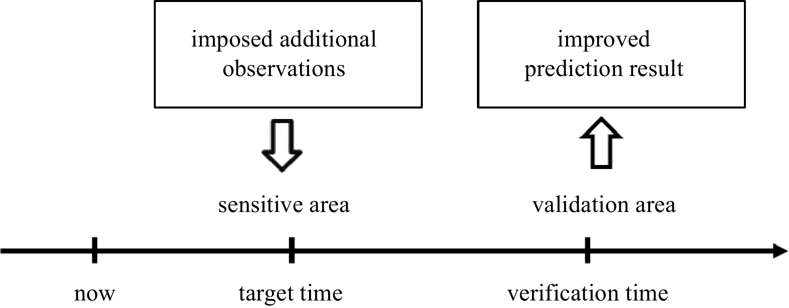
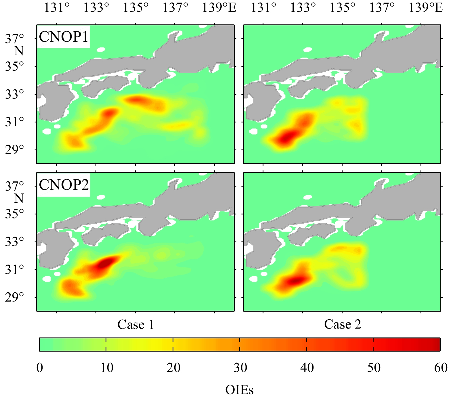
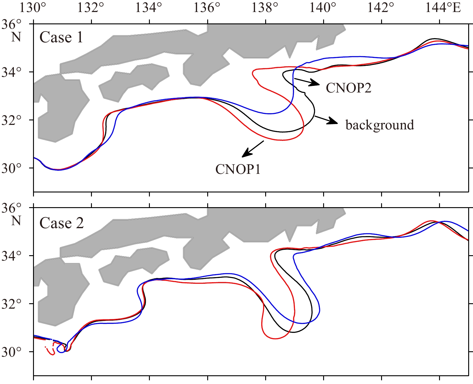
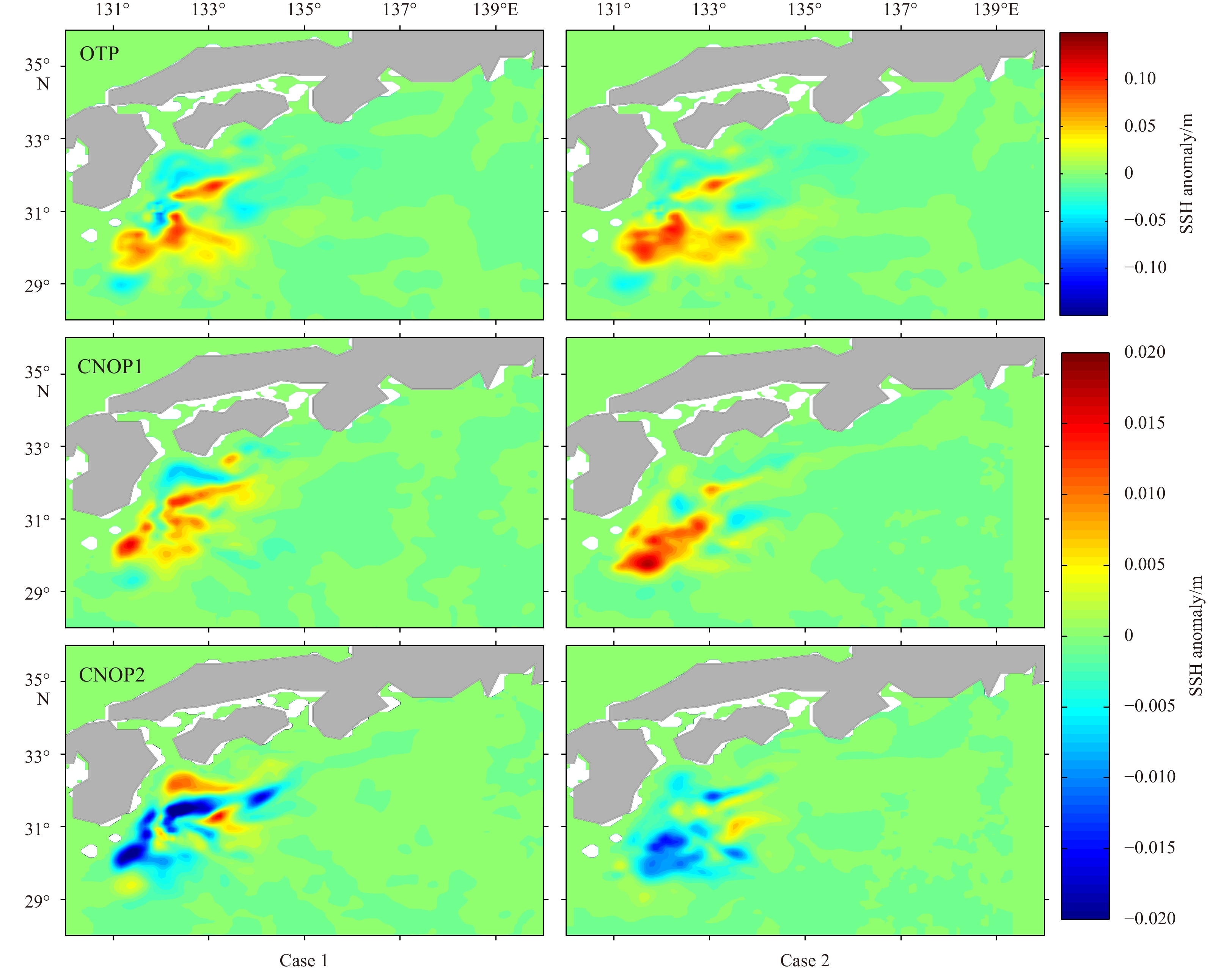
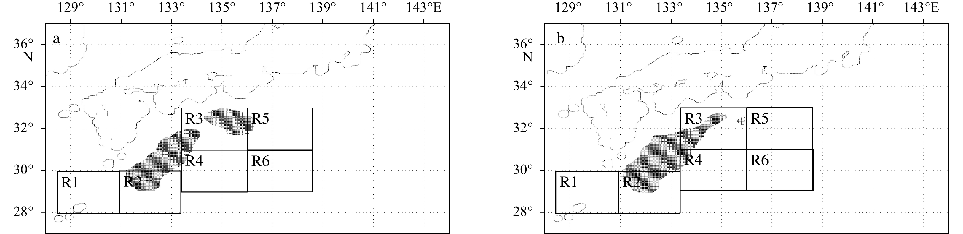
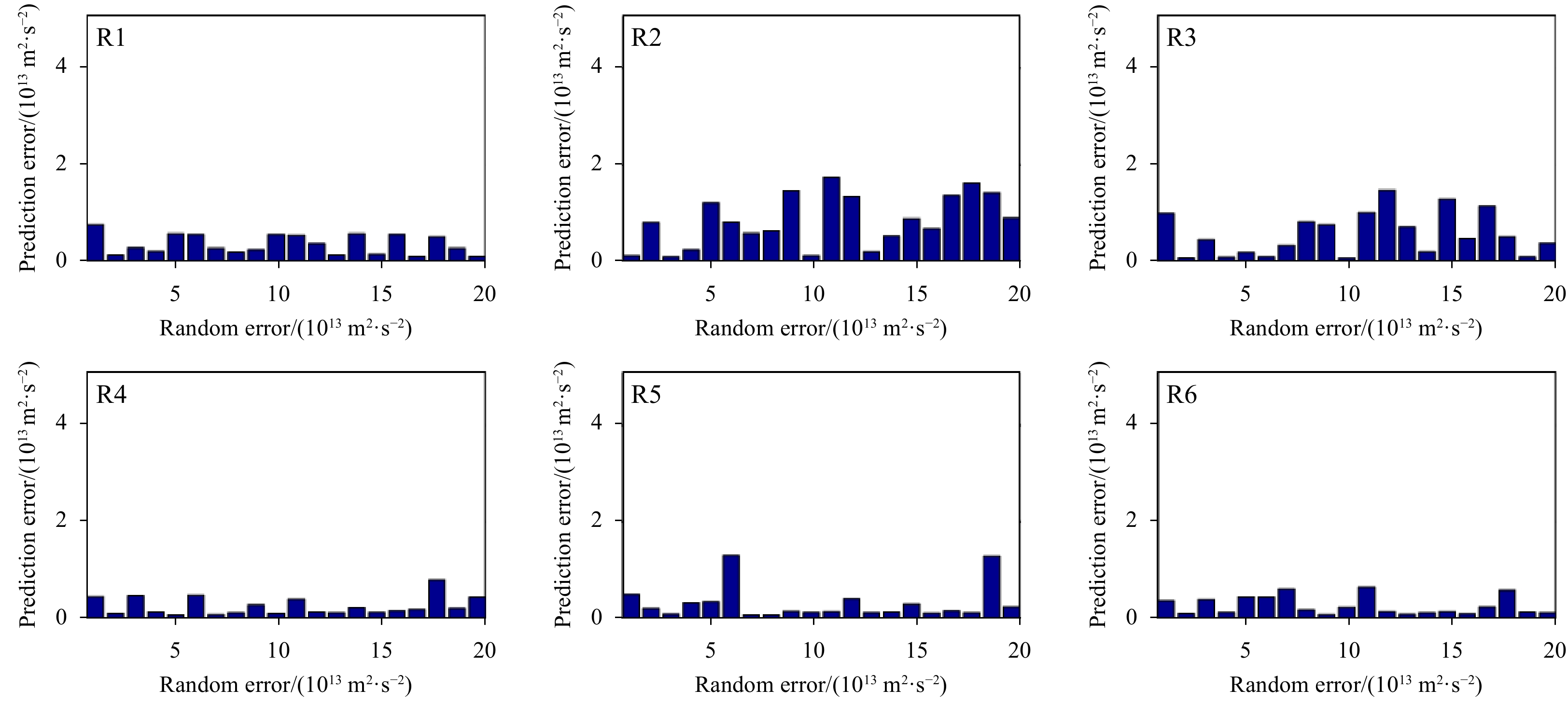
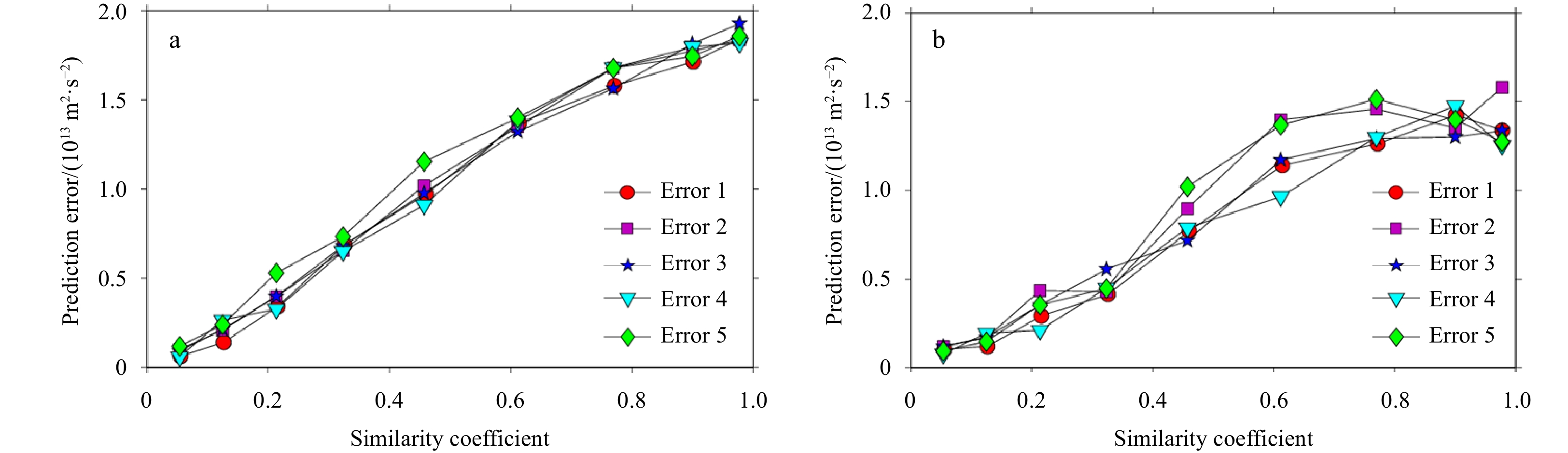
With the Regional Ocean Modeling System (ROMS), this paper investigates the sensitive areas in targeted observation for predicting the Kuroshio large meander (LM) path using the conditional nonlinear optimal perturbation approach. To identify the sensitive areas, the optimal initial errors (OIEs) featuring the largest nonlinear evolution in the LM prediction are first calculated; the resulting OIEs are localized mainly in the upper 2 500 m over the LM upstream region, and their spatial structure has certain similarities with that of the optimal triggering perturbation. Based on this spatial structure, the sensitive areas are successfully identified, located southeast of Kyushu in the region (29°–32°N, 131°–134°E). A series of sensitivity experiments indicate that both the positions and the spatial structure of initial errors have important effects on the LM prediction, verifying the validity of the sensitive areas. Then, the effect of targeted observation in the sensitive areas is evaluated through observing system simulation experiments. When targeted observation is implemented in the identified sensitive areas, the prediction errors are effectively reduced, and the prediction skill of the LM event is improved significantly. This provides scientific guidance for ocean observations related to enhancing the prediction skill of the LM event.
With the Regional Ocean Modeling System (ROMS), this paper investigates the sensitive areas in targeted observation for predicting the Kuroshio large meander (LM) path using the conditional nonlinear optimal perturbation approach. To identify the sensitive areas, the optimal initial errors (OIEs) featuring the largest nonlinear evolution in the LM prediction are first calculated; the resulting OIEs are localized mainly in the upper 2 500 m over the LM upstream region, and their spatial structure has certain similarities with that of the optimal triggering perturbation. Based on this spatial structure, the sensitive areas are successfully identified, located southeast of Kyushu in the region (29°–32°N, 131°–134°E). A series of sensitivity experiments indicate that both the positions and the spatial structure of initial errors have important effects on the LM prediction, verifying the validity of the sensitive areas. Then, the effect of targeted observation in the sensitive areas is evaluated through observing system simulation experiments. When targeted observation is implemented in the identified sensitive areas, the prediction errors are effectively reduced, and the prediction skill of the LM event is improved significantly. This provides scientific guidance for ocean observations related to enhancing the prediction skill of the LM event.


2022, 41(2): 15-25.
doi: 10.1007/s13131-021-1941-9
Abstract:
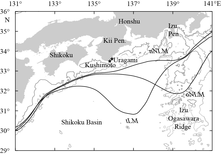
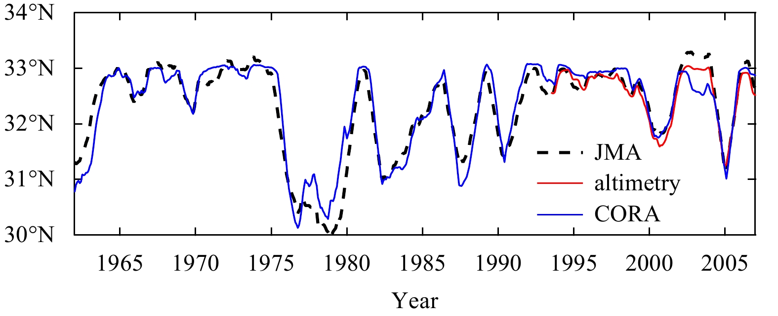
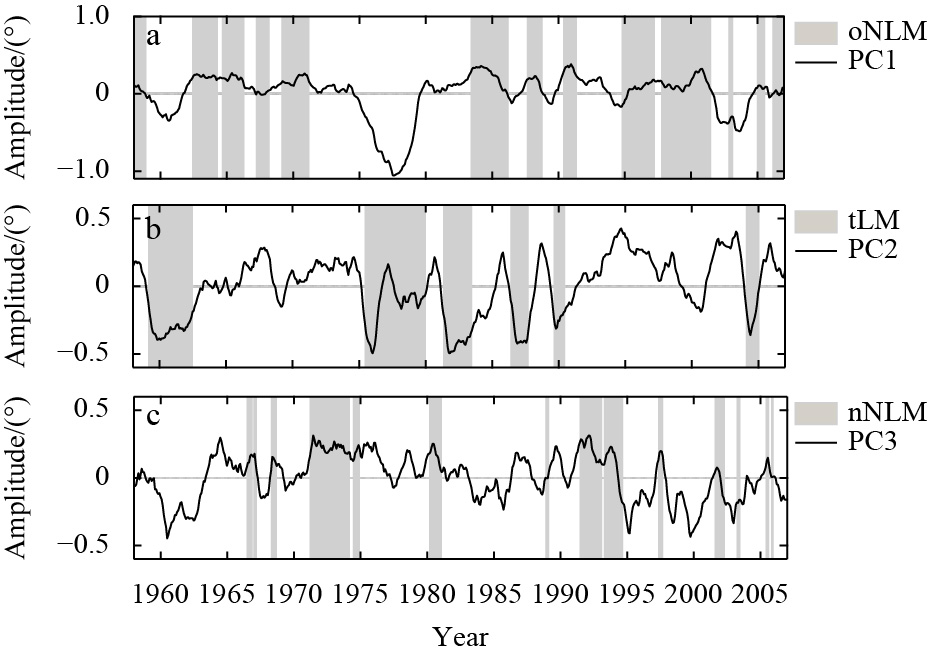
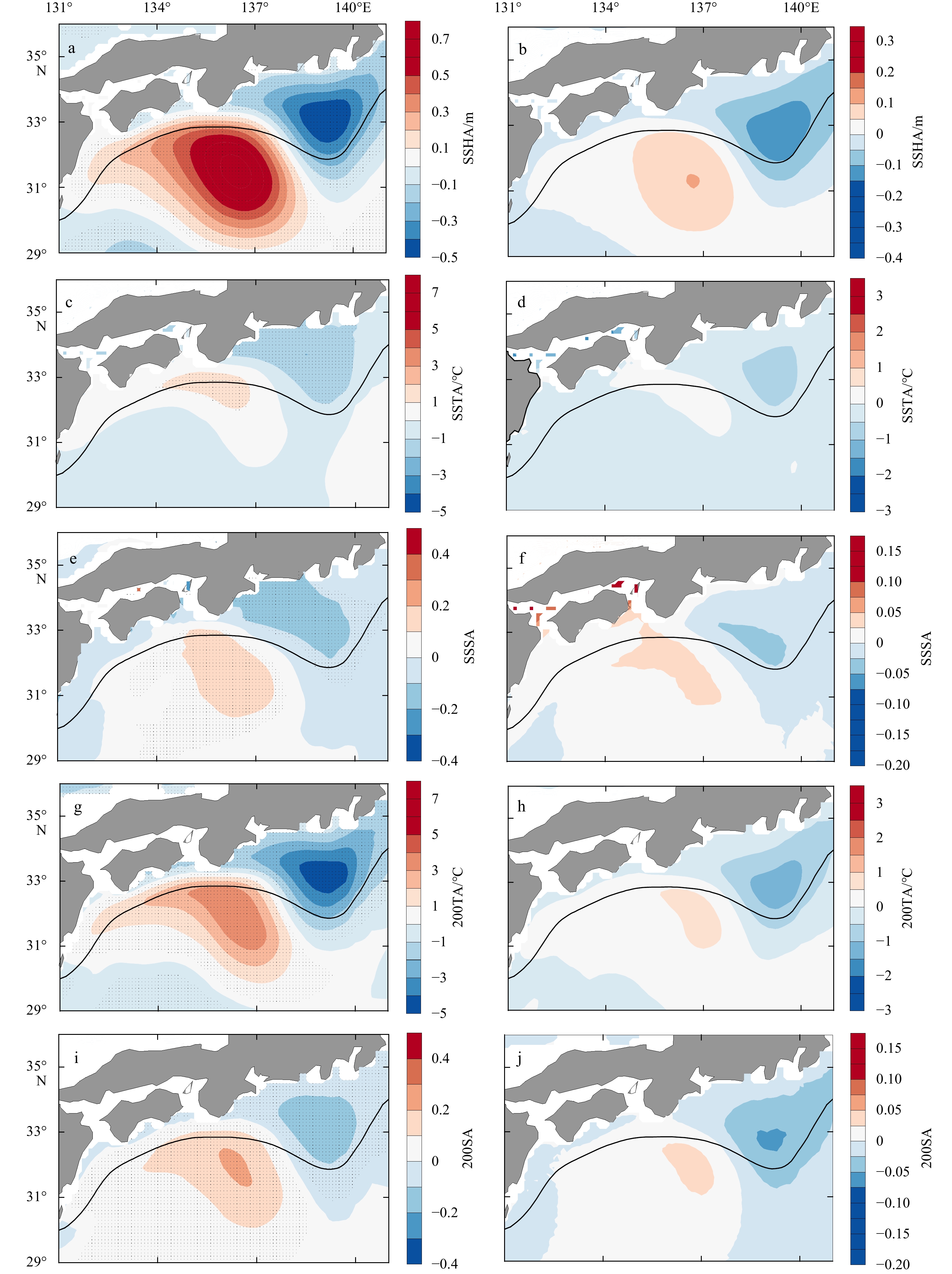
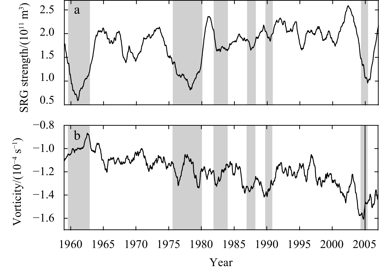
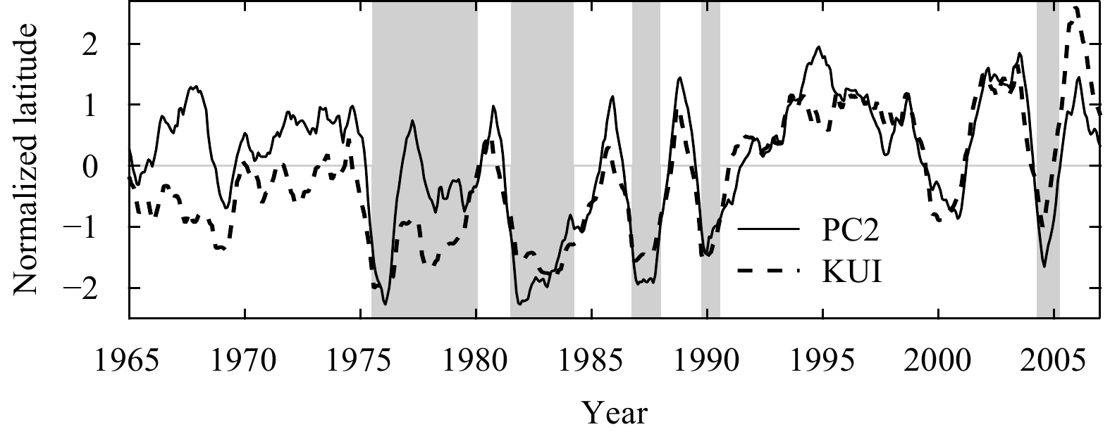
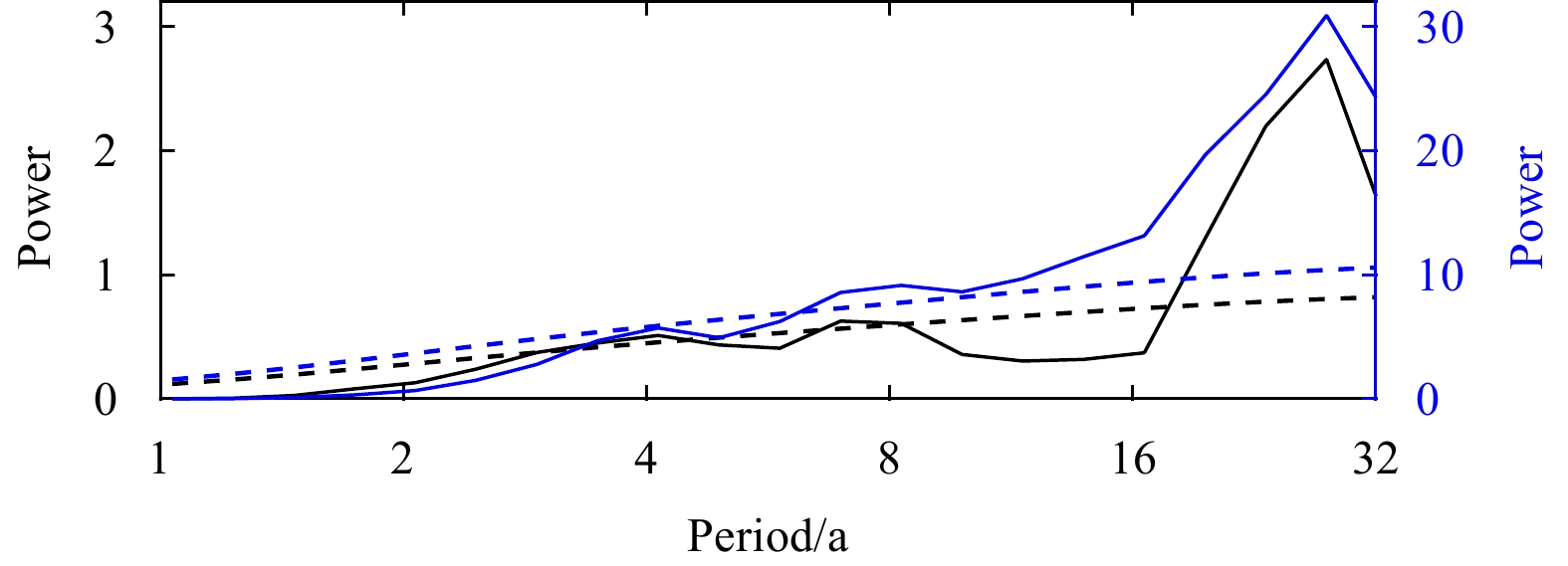
Empirical orthogonal function (EOF) analysis was applied to a 50-year long time series of monthly mean positions of the Kuroshio path south of Japan from a regional reanalysis. Three leading EOF modes characterize the contributions from three typical paths of the Kuroshio meander: the typical large meander path, the offshore non-large meander path, and the nearshore non-large meander path, respectively. Accordingly, the spatial variation characteristics of oceanic anomaly fields can be depicted by their regression fields upon the associated three leading principal components (PCs), which are well-matched with the results of composite analysis corresponding to each period of the three typical Kuroshio paths. A new index for the typical large meander is defined by using the second leading PC, which is highly correlated with the Kushimoto-Uragami index. Spectral analysis of this new index series shows variability of the Kuroshio path south of Japan at time scales of about 7–8 years and 20 years.
Empirical orthogonal function (EOF) analysis was applied to a 50-year long time series of monthly mean positions of the Kuroshio path south of Japan from a regional reanalysis. Three leading EOF modes characterize the contributions from three typical paths of the Kuroshio meander: the typical large meander path, the offshore non-large meander path, and the nearshore non-large meander path, respectively. Accordingly, the spatial variation characteristics of oceanic anomaly fields can be depicted by their regression fields upon the associated three leading principal components (PCs), which are well-matched with the results of composite analysis corresponding to each period of the three typical Kuroshio paths. A new index for the typical large meander is defined by using the second leading PC, which is highly correlated with the Kushimoto-Uragami index. Spectral analysis of this new index series shows variability of the Kuroshio path south of Japan at time scales of about 7–8 years and 20 years.


2022, 41(2): 26-40.
doi: 10.1007/s13131-021-1903-2
Abstract:
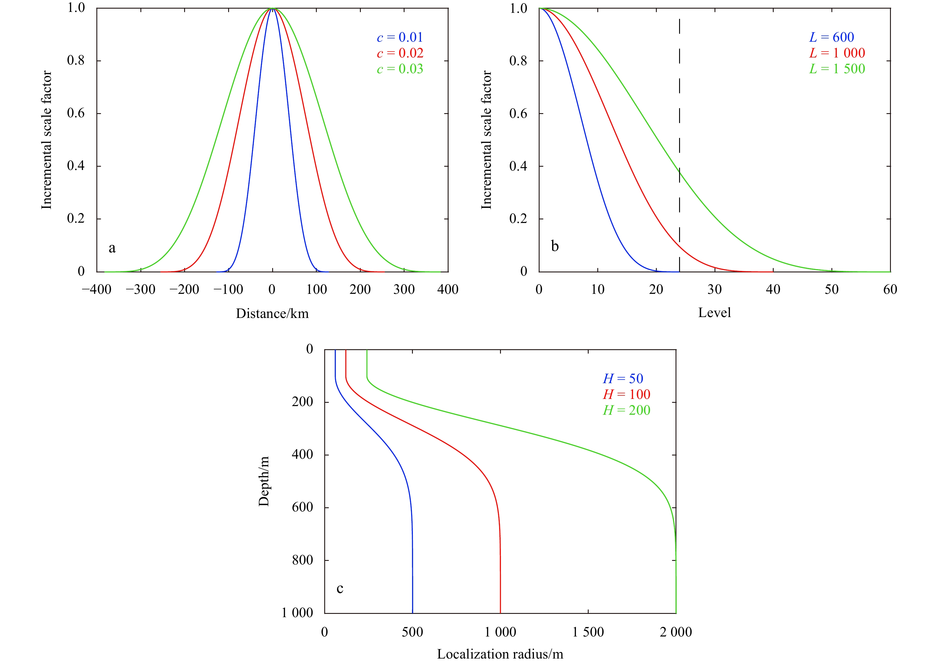
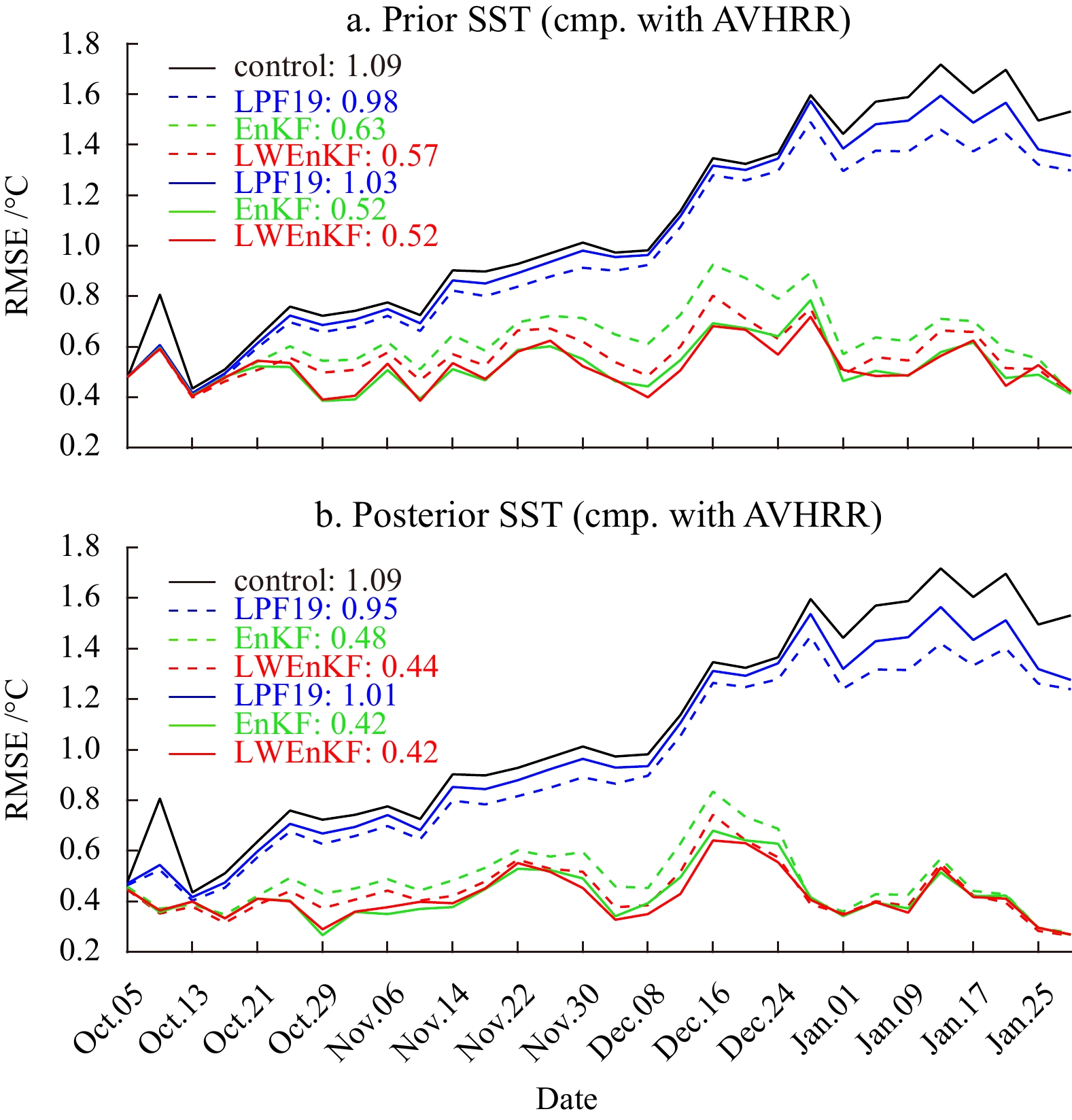
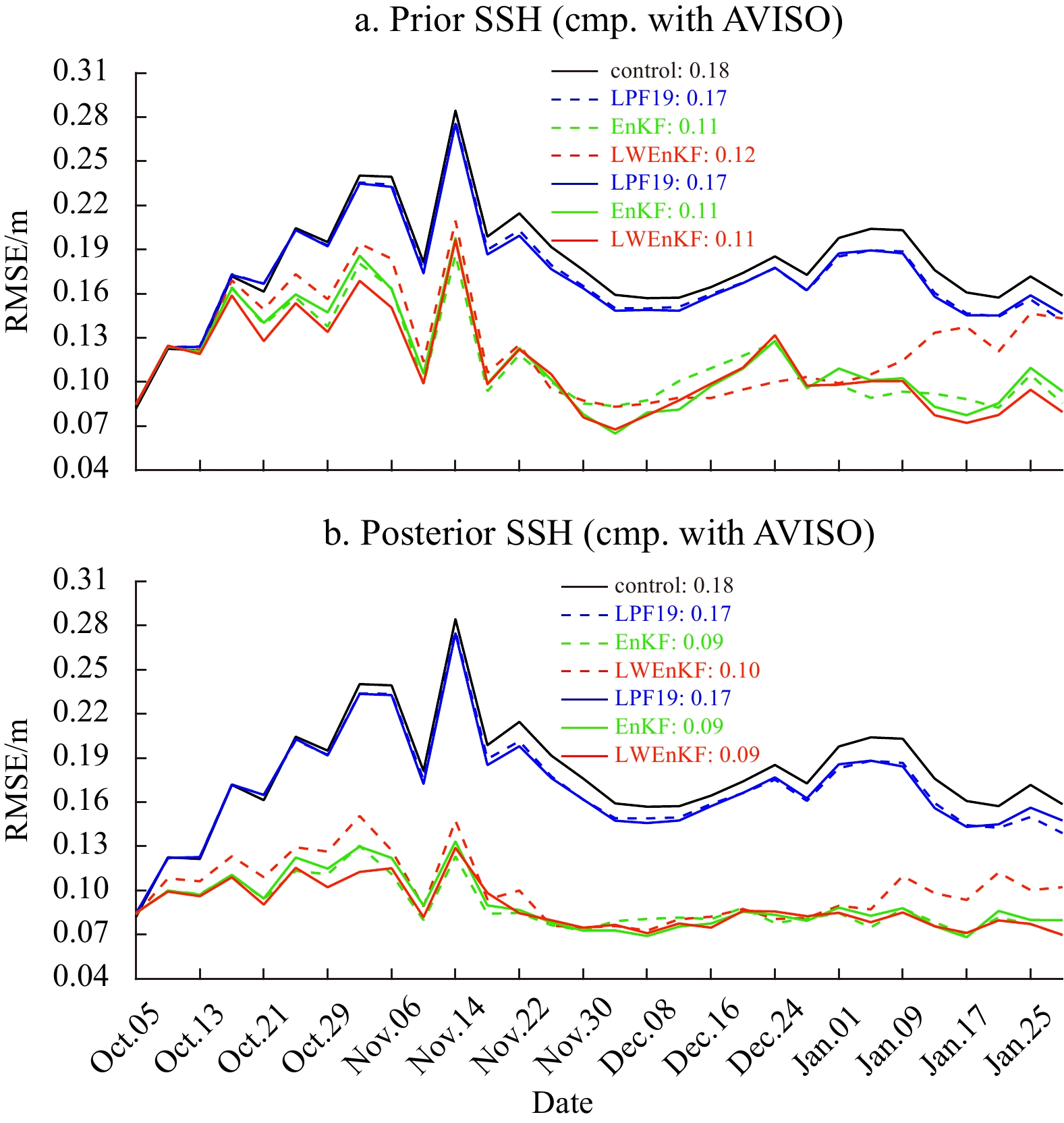
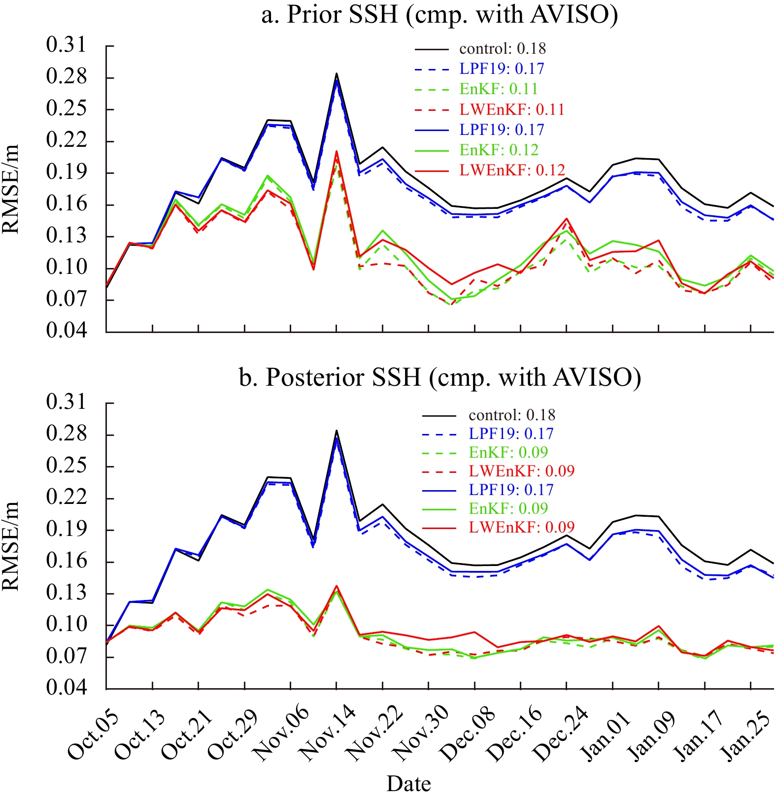
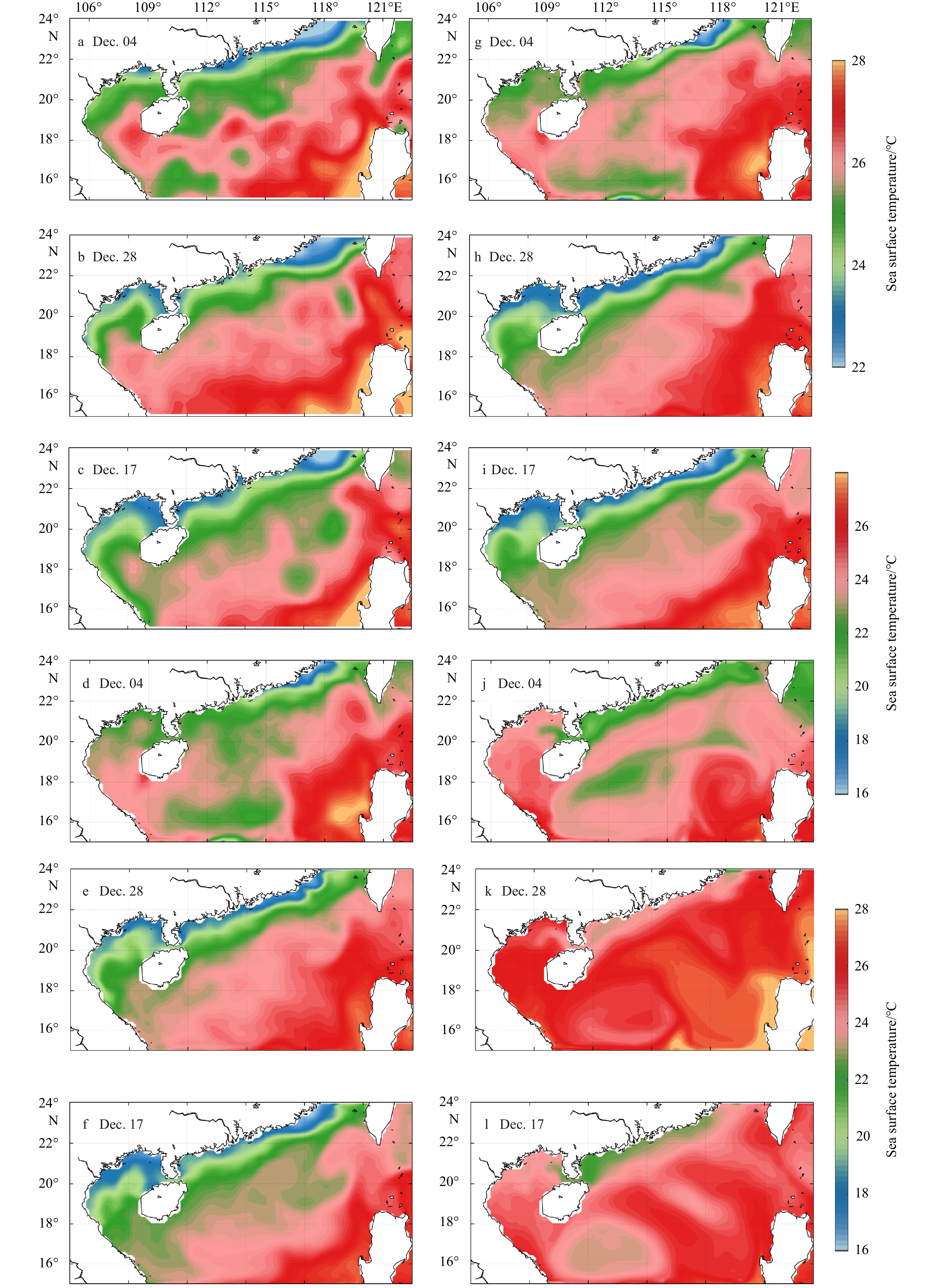
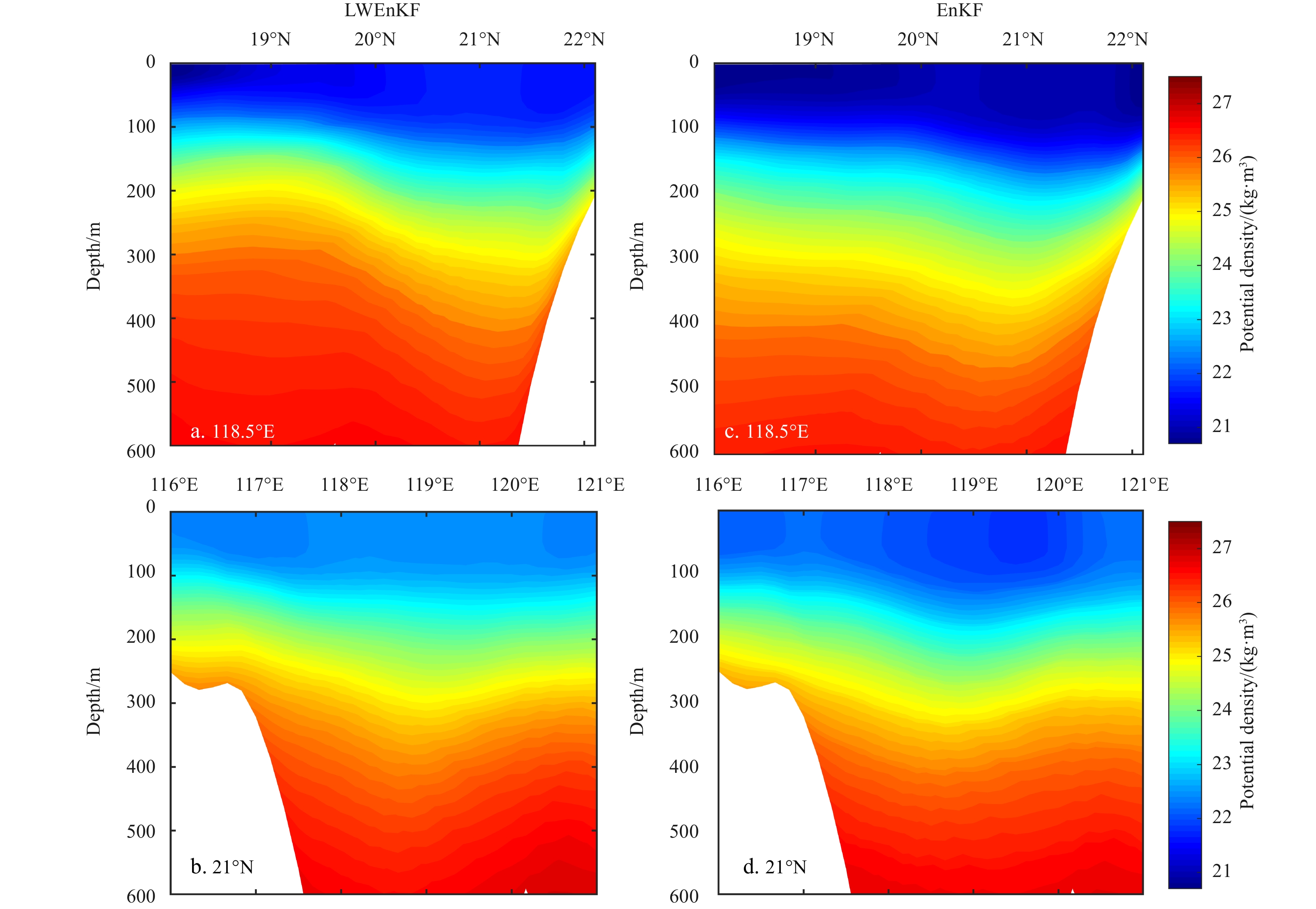
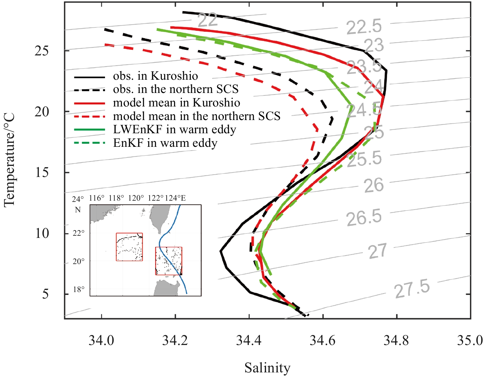
The Localized Weighted Ensemble Kalman Filter (LWEnKF) is a new nonlinear/non-Gaussian data assimilation (DA) method that can effectively alleviate the filter degradation problem faced by particle filtering, and it has great prospects for applications in geophysical models. In terms of operational applications, along-track sea surface height (AT-SSH), swath sea surface temperature (S-SST) and in-situ temperature and salinity (T/S) profiles are assimilated using the LWEnKF in the northern South China Sea (SCS). To adapt to the vertical S-coordinates of the Regional Ocean Modelling System (ROMS), a vertical localization radius function is designed for T/S profiles assimilation using the LWEnKF. The results show that the LWEnKF outperforms the local particle filter (LPF) due to the introduction of the Ensemble Kalman Filter (EnKF) as a proposal density; the RMSEs of SSH and SST from the LWEnKF are comparable to the EnKF, but the RMSEs of T/S profiles reduce significantly by approximately 55% for the T profile and 35% for the S profile (relative to the EnKF). As a result, the LWEnKF makes more reasonable predictions of the internal ocean temperature field. In addition, the three-dimensional structures of nonlinear mesoscale eddies are better characterized when using the LWEnKF.
The Localized Weighted Ensemble Kalman Filter (LWEnKF) is a new nonlinear/non-Gaussian data assimilation (DA) method that can effectively alleviate the filter degradation problem faced by particle filtering, and it has great prospects for applications in geophysical models. In terms of operational applications, along-track sea surface height (AT-SSH), swath sea surface temperature (S-SST) and in-situ temperature and salinity (T/S) profiles are assimilated using the LWEnKF in the northern South China Sea (SCS). To adapt to the vertical S-coordinates of the Regional Ocean Modelling System (ROMS), a vertical localization radius function is designed for T/S profiles assimilation using the LWEnKF. The results show that the LWEnKF outperforms the local particle filter (LPF) due to the introduction of the Ensemble Kalman Filter (EnKF) as a proposal density; the RMSEs of SSH and SST from the LWEnKF are comparable to the EnKF, but the RMSEs of T/S profiles reduce significantly by approximately 55% for the T profile and 35% for the S profile (relative to the EnKF). As a result, the LWEnKF makes more reasonable predictions of the internal ocean temperature field. In addition, the three-dimensional structures of nonlinear mesoscale eddies are better characterized when using the LWEnKF.


2022, 41(2): 41-50.
doi: 10.1007/s13131-021-1880-5
Abstract:
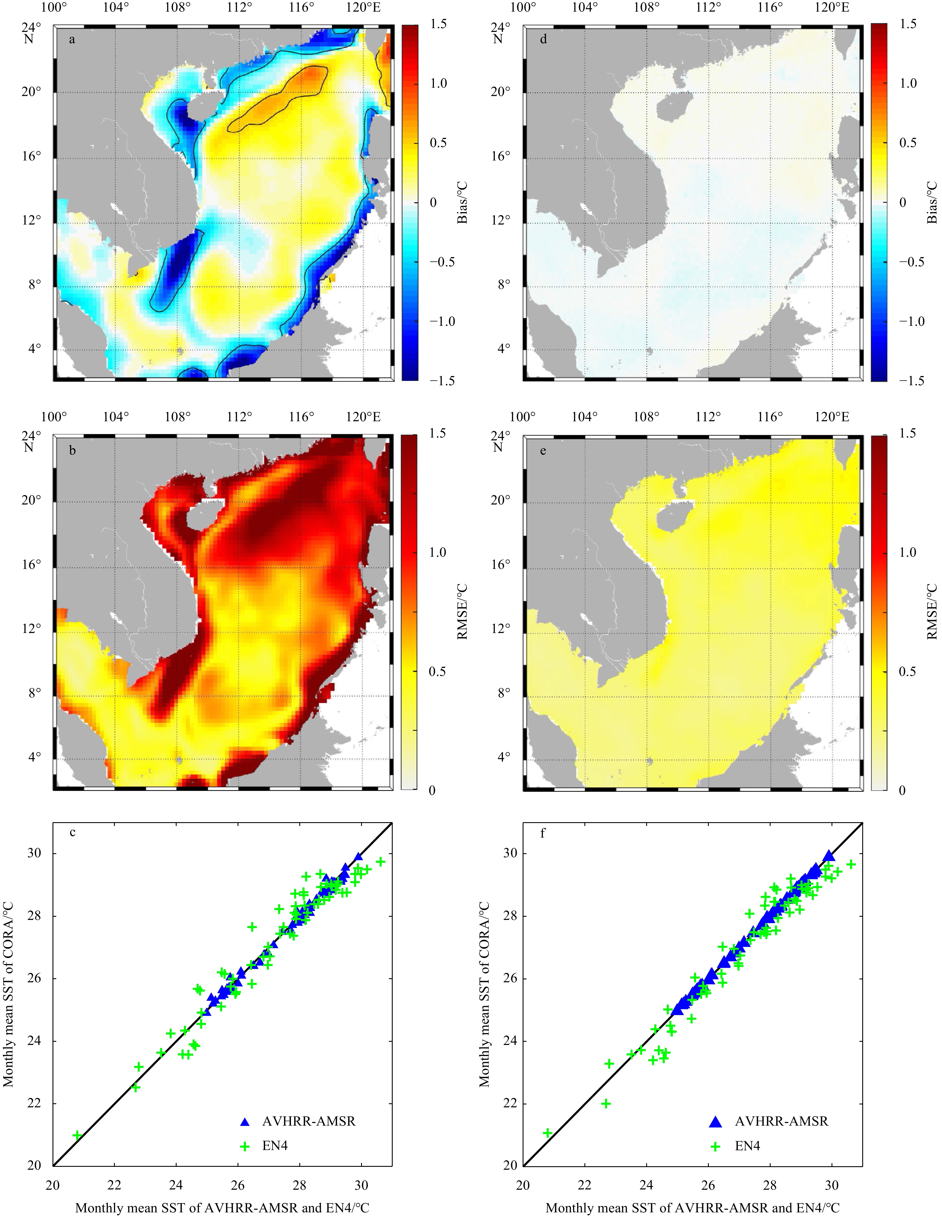
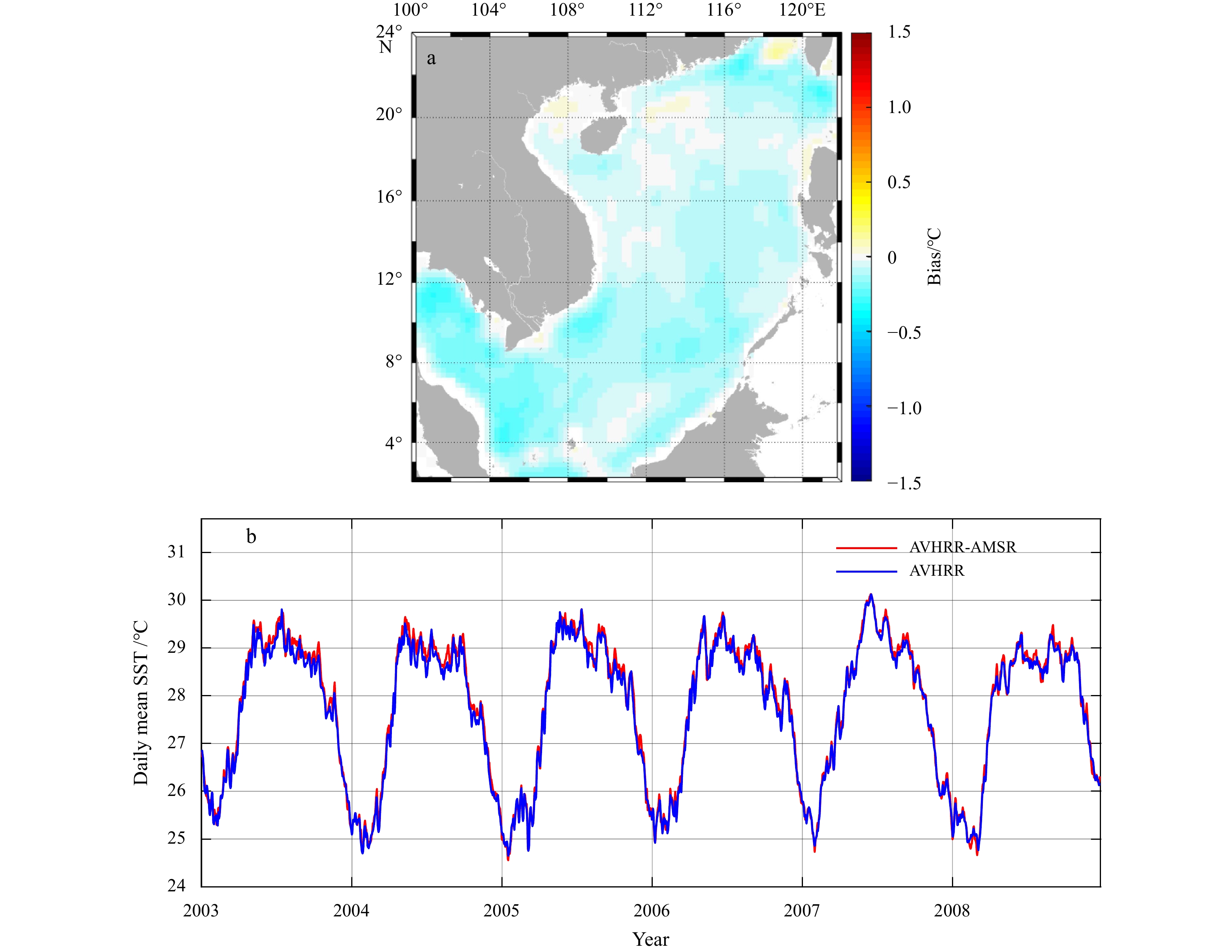
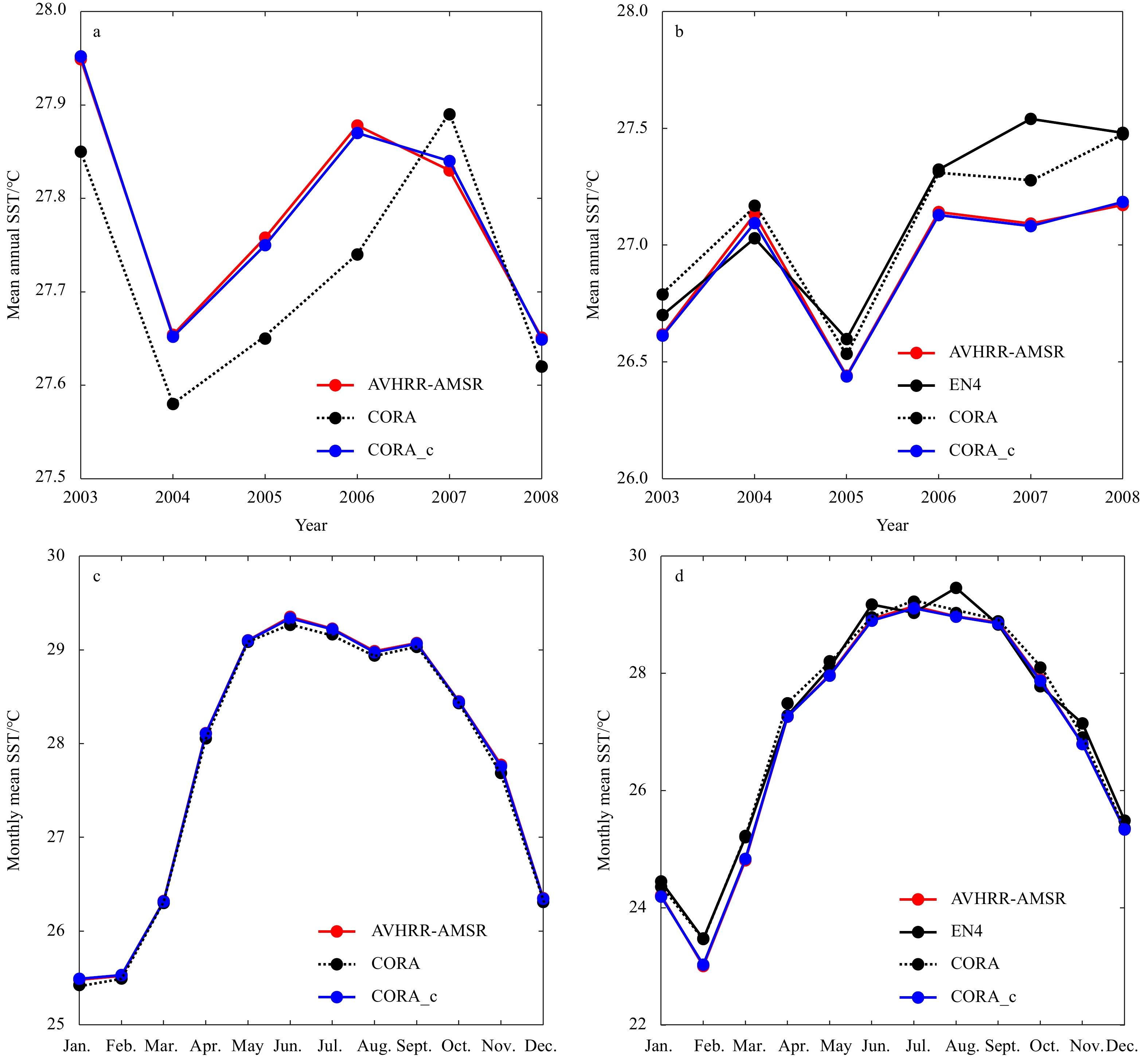
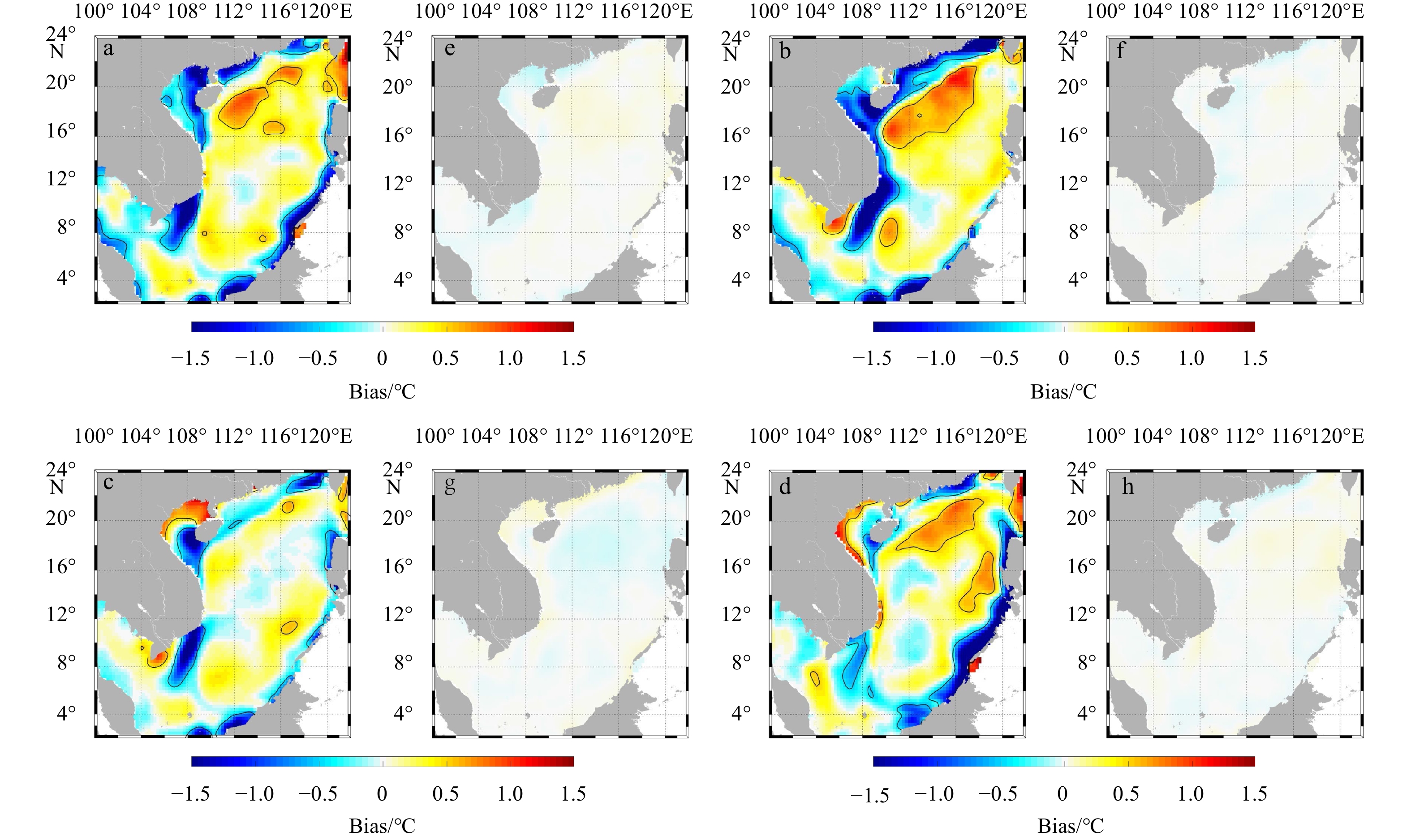
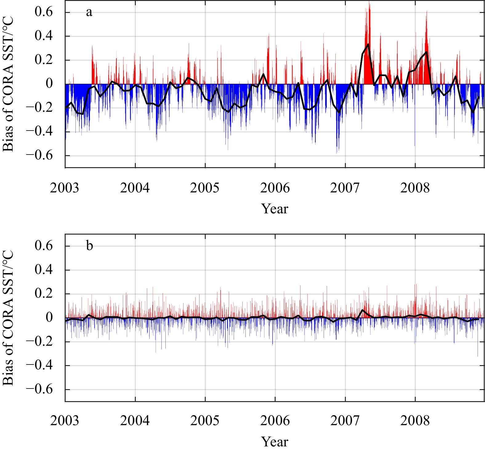
Offline bias correction of numerical marine forecast products is an effective post-processing means to improve forecast accuracy. Two offline bias correction methods for sea surface temperature (SST) forecasts have been developed in this study: a backpropagation neural network (BPNN) algorithm, and a hybrid algorithm of empirical orthogonal function (EOF) analysis and BPNN (named EOF-BPNN). The performances of these two methods are validated using bias correction experiments implemented in the South China Sea (SCS), in which the target dataset is a six-year (2003–2008) daily mean time series of SST retrospective forecasts for one-day in advance, obtained from a regional ocean forecast and analysis system called the China Ocean Reanalysis (CORA), and the reference time series is the gridded satellite-based SST. The bias-correction results show that the two methods have similar good skills; however, the EOF-BPNN method is more than five times faster than the BPNN method. Before applying the bias correction, the basin-wide climatological error of the daily mean CORA SST retrospective forecasts in the SCS is up to −3°C; now, it is minimized substantially, falling within the error range (±0.5°C) of the satellite SST data.
Offline bias correction of numerical marine forecast products is an effective post-processing means to improve forecast accuracy. Two offline bias correction methods for sea surface temperature (SST) forecasts have been developed in this study: a backpropagation neural network (BPNN) algorithm, and a hybrid algorithm of empirical orthogonal function (EOF) analysis and BPNN (named EOF-BPNN). The performances of these two methods are validated using bias correction experiments implemented in the South China Sea (SCS), in which the target dataset is a six-year (2003–2008) daily mean time series of SST retrospective forecasts for one-day in advance, obtained from a regional ocean forecast and analysis system called the China Ocean Reanalysis (CORA), and the reference time series is the gridded satellite-based SST. The bias-correction results show that the two methods have similar good skills; however, the EOF-BPNN method is more than five times faster than the BPNN method. Before applying the bias correction, the basin-wide climatological error of the daily mean CORA SST retrospective forecasts in the SCS is up to −3°C; now, it is minimized substantially, falling within the error range (±0.5°C) of the satellite SST data.

2022, 41(2): 51-64.
doi: 10.1007/s13131-021/1857-4
Abstract:
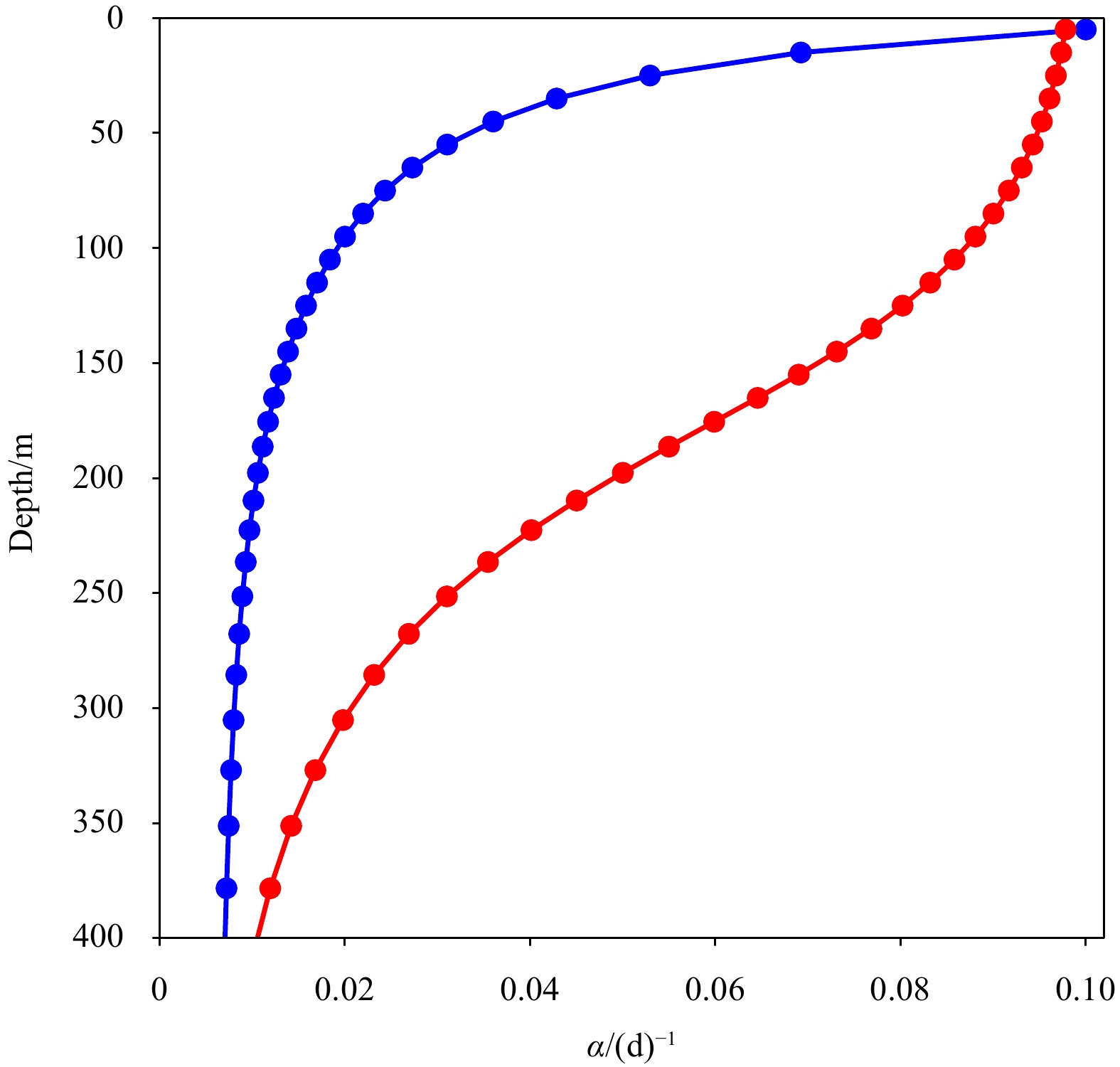
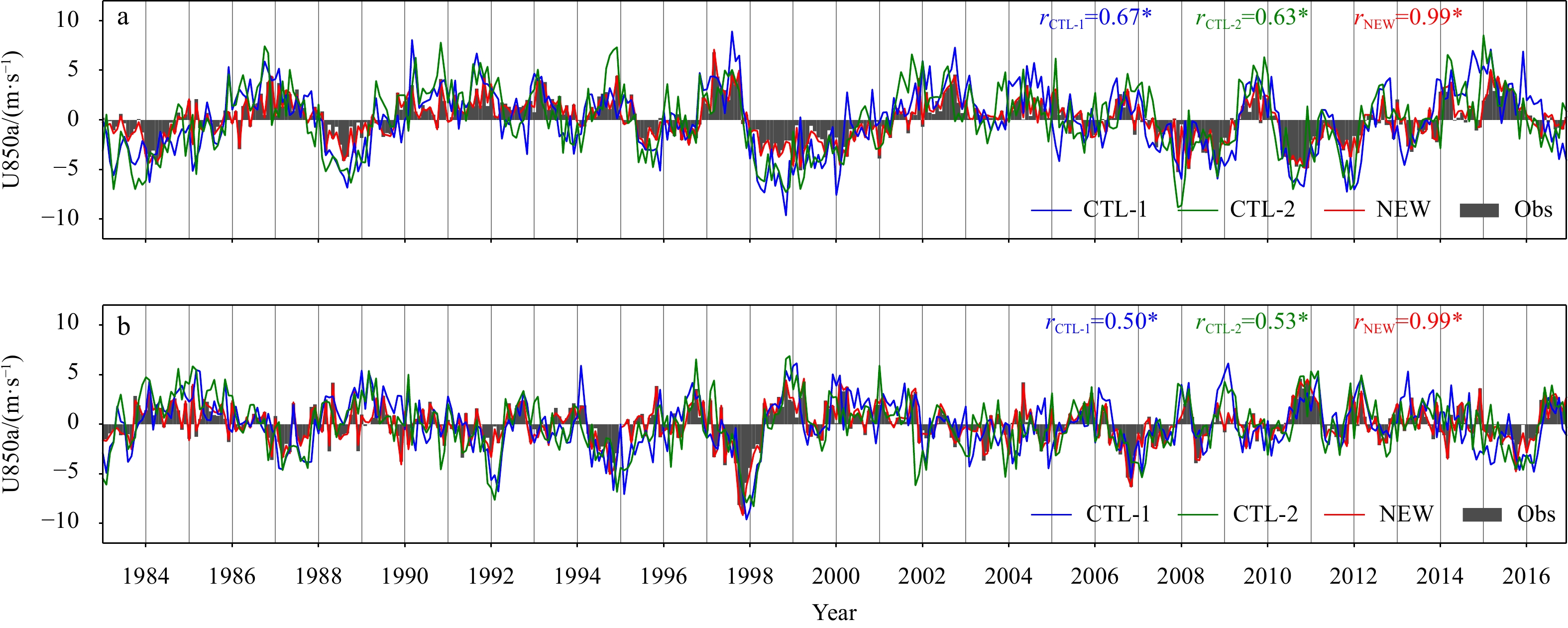
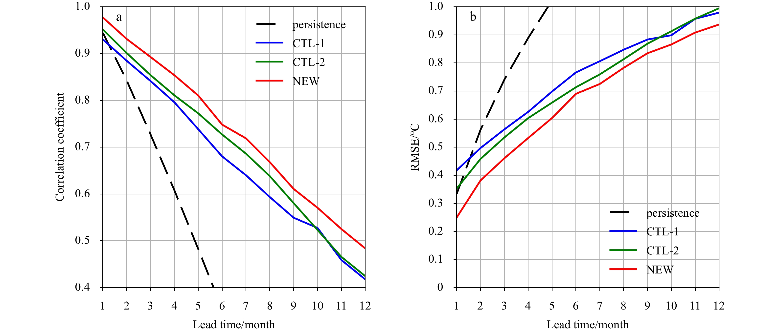
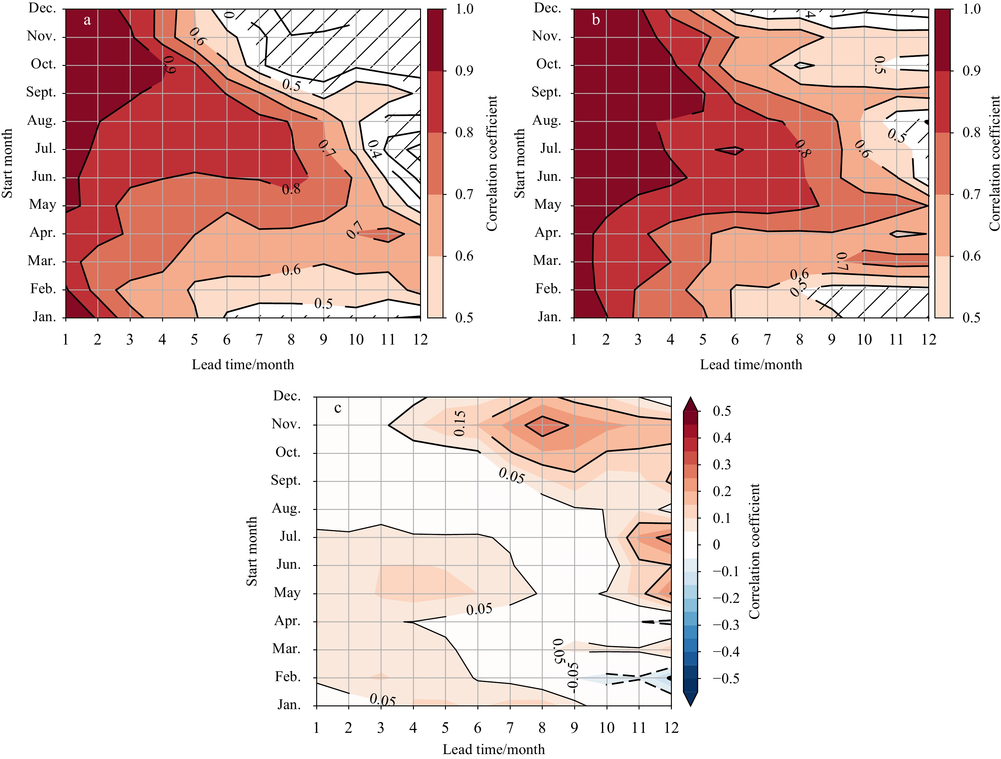
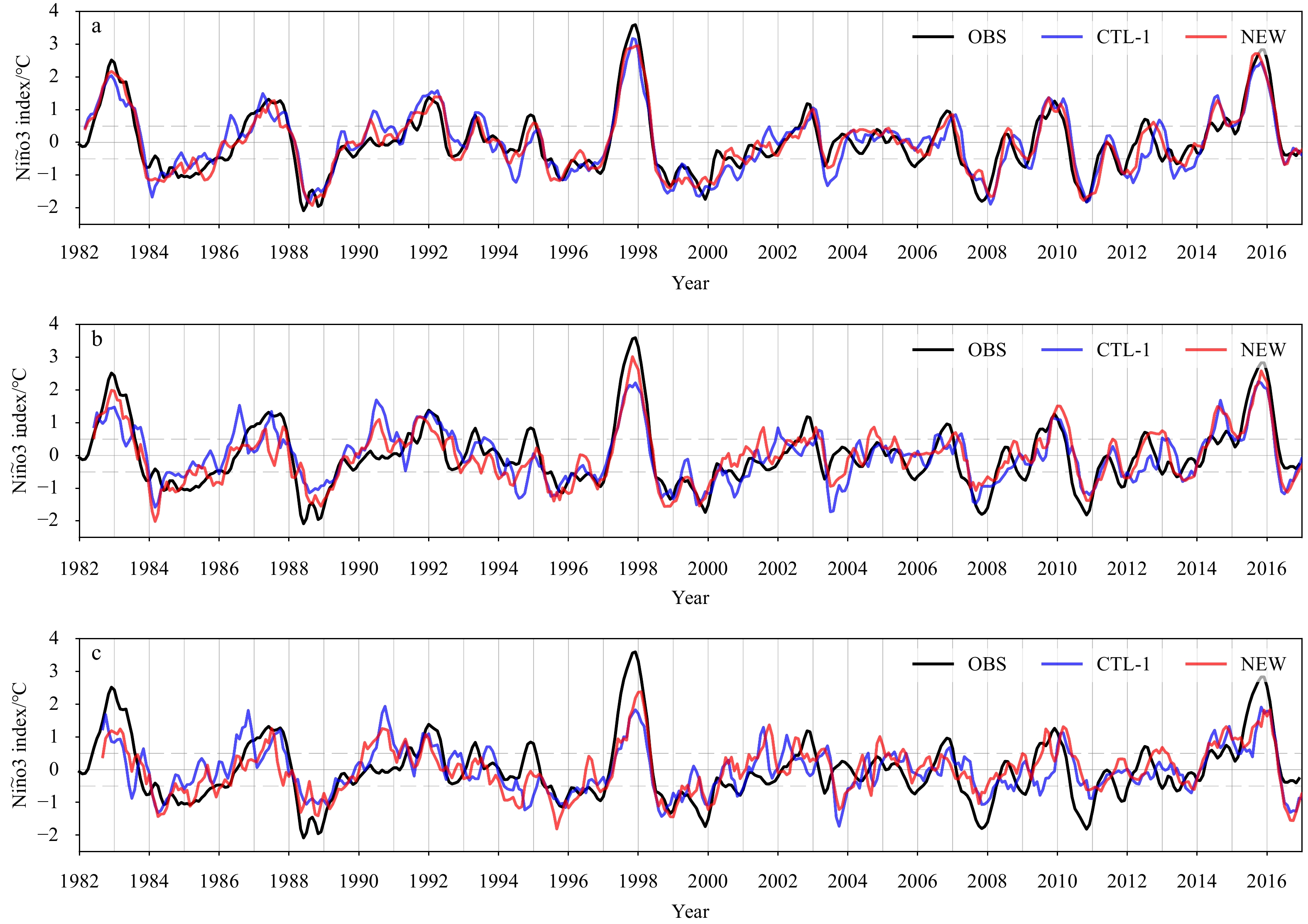
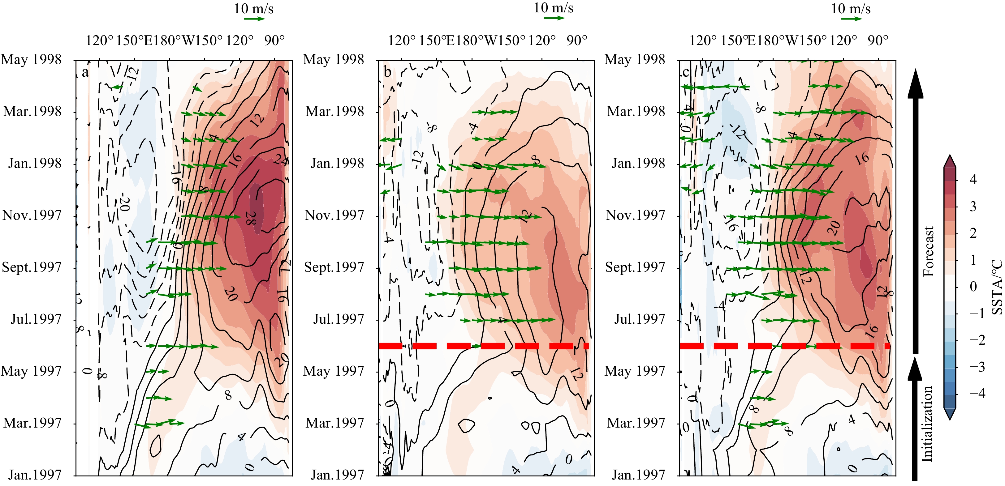
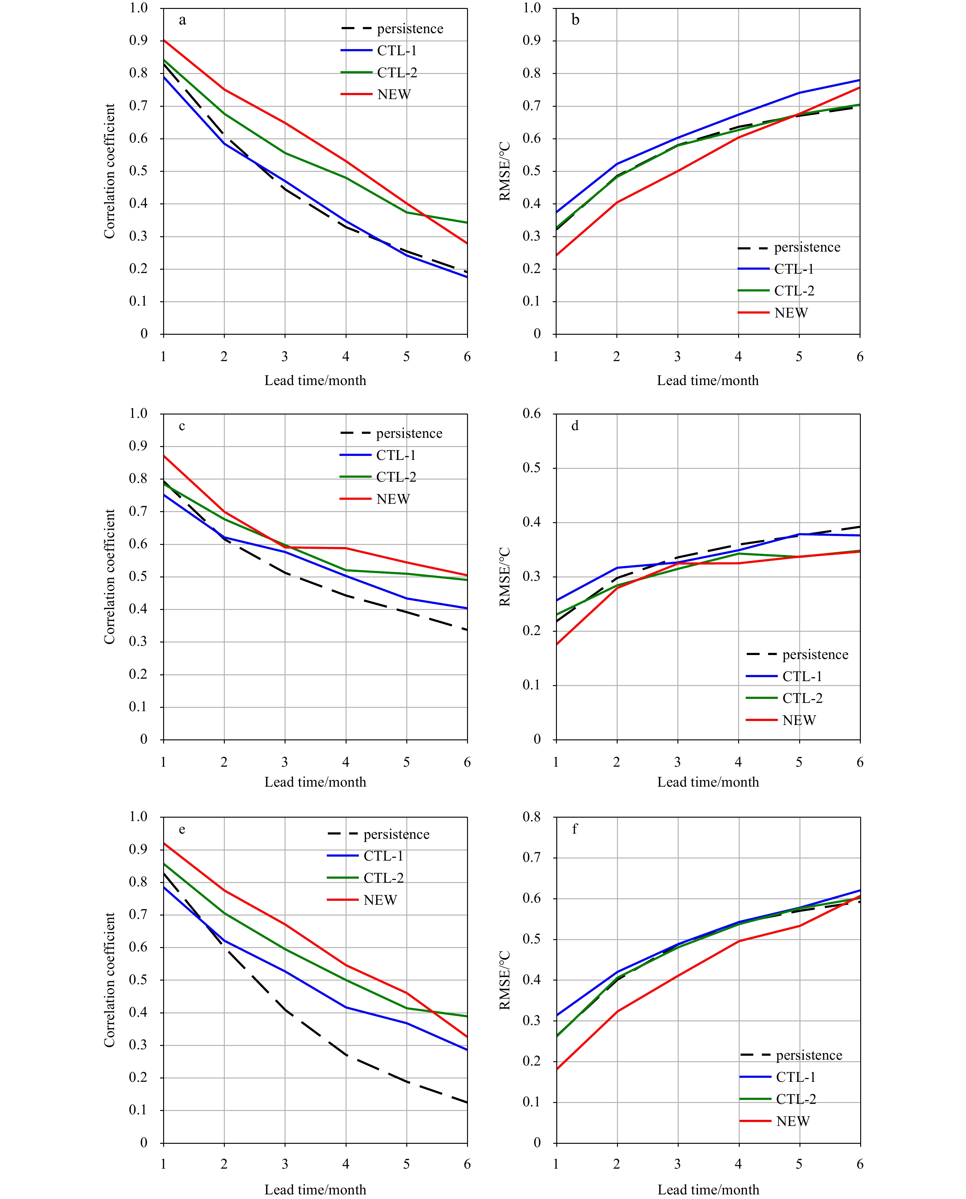
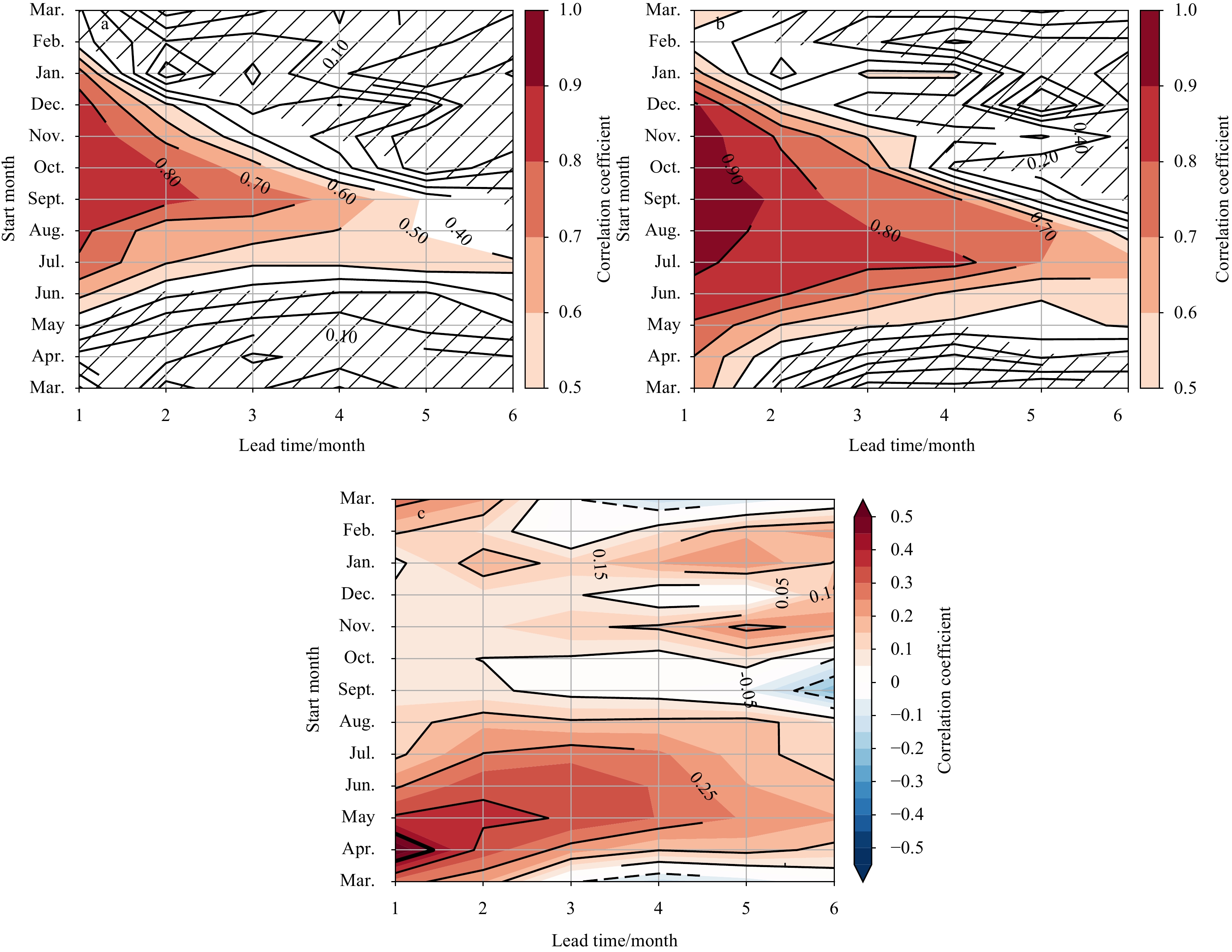
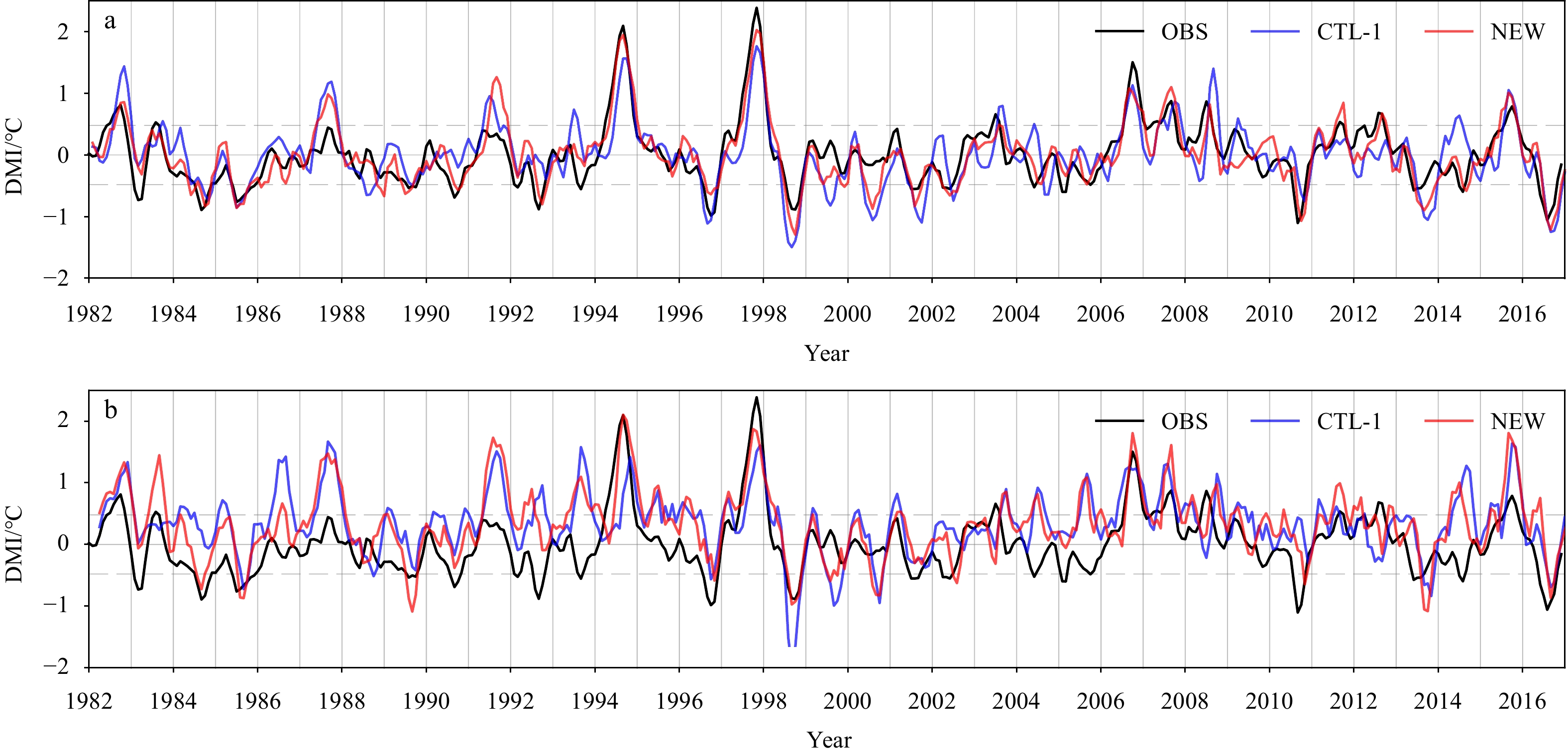
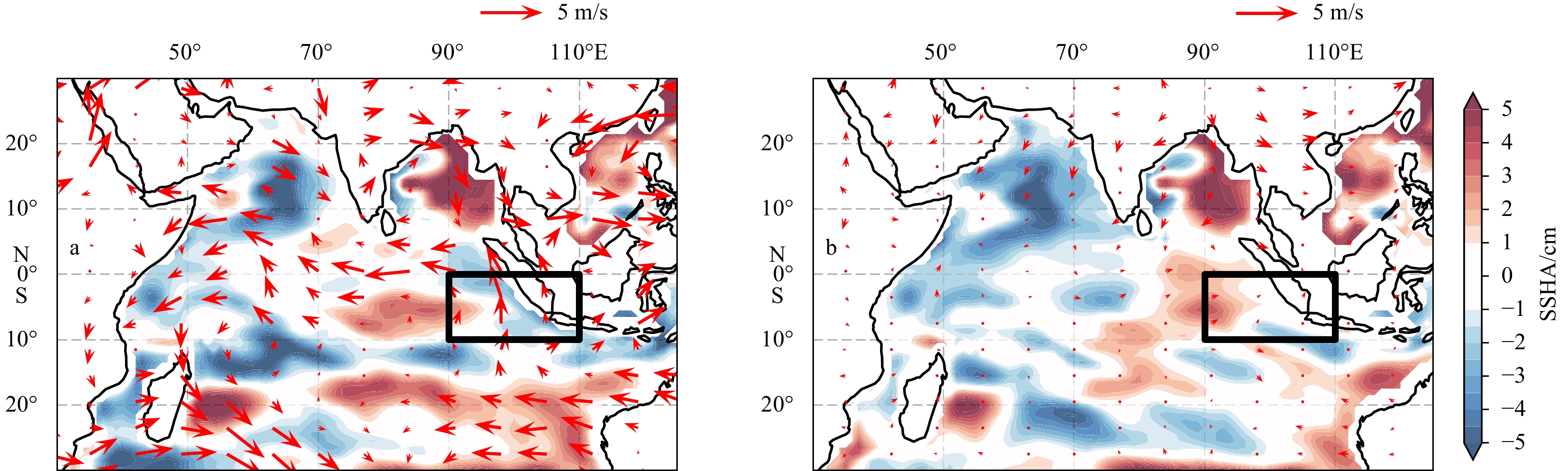
A new nudging scheme is proposed for the operational prediction system of the National Marine Environmental Forecasting Center (NMEFC) of China, mainly aimed at improving El Niño–Southern Oscillation (ENSO) and Indian Ocean Dipole (IOD) predictions. Compared with the origin nudging scheme of NMEFC, the new scheme adds a nudge assimilation for wind components, and increases the nudging weight at the subsurface. Increasing the nudging weight at the subsurface directly improved the simulation performance of the ocean component, while assimilating low-level wind components not only affected the atmospheric component but also benefited the oceanic simulation. Hindcast experiments showed that the new scheme remarkably improved both ENSO and IOD prediction skills. The skillful prediction lead time of ENSO was up to 11 months, 1 month longer than a hindcast using the original nudging scheme. Skillful prediction of IOD could be made 4–5 months ahead by the new scheme, with a 0.2 higher correlation at a 3-month lead time. These prediction skills approach the level of some of the best state-of-the-art coupled general circulation models. Improved ENSO and IOD predictions occurred across all seasons, but mainly for target months in the boreal spring for the ENSO and the boreal spring and summer for the IOD.
A new nudging scheme is proposed for the operational prediction system of the National Marine Environmental Forecasting Center (NMEFC) of China, mainly aimed at improving El Niño–Southern Oscillation (ENSO) and Indian Ocean Dipole (IOD) predictions. Compared with the origin nudging scheme of NMEFC, the new scheme adds a nudge assimilation for wind components, and increases the nudging weight at the subsurface. Increasing the nudging weight at the subsurface directly improved the simulation performance of the ocean component, while assimilating low-level wind components not only affected the atmospheric component but also benefited the oceanic simulation. Hindcast experiments showed that the new scheme remarkably improved both ENSO and IOD prediction skills. The skillful prediction lead time of ENSO was up to 11 months, 1 month longer than a hindcast using the original nudging scheme. Skillful prediction of IOD could be made 4–5 months ahead by the new scheme, with a 0.2 higher correlation at a 3-month lead time. These prediction skills approach the level of some of the best state-of-the-art coupled general circulation models. Improved ENSO and IOD predictions occurred across all seasons, but mainly for target months in the boreal spring for the ENSO and the boreal spring and summer for the IOD.


2022, 41(2): 65-79.
doi: 10.1007/s13131-021/1858-3
Abstract:
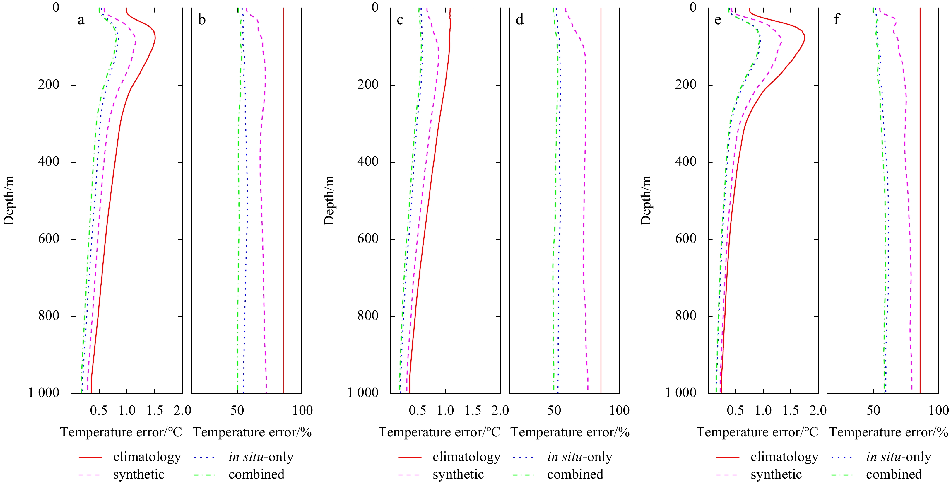
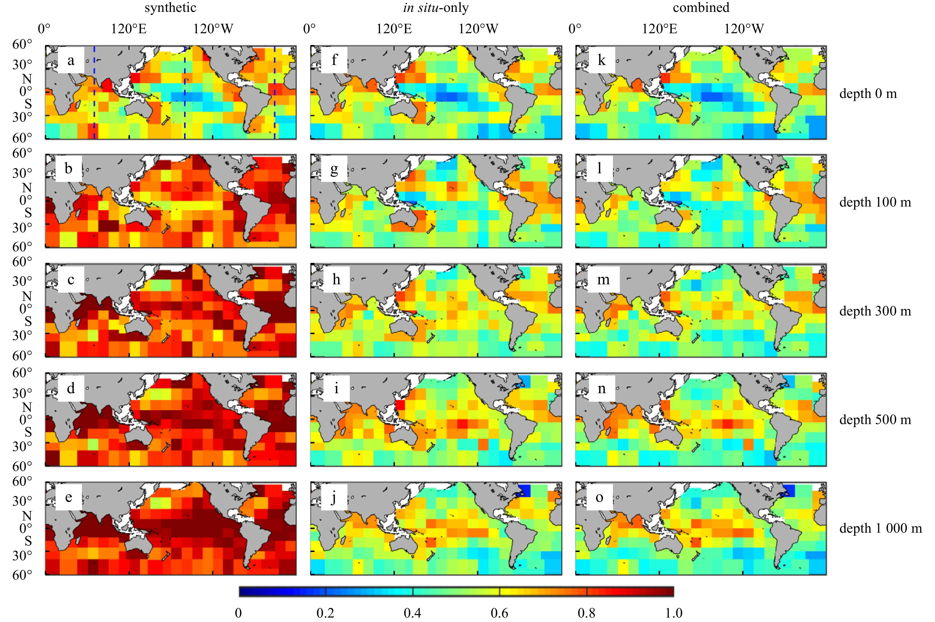
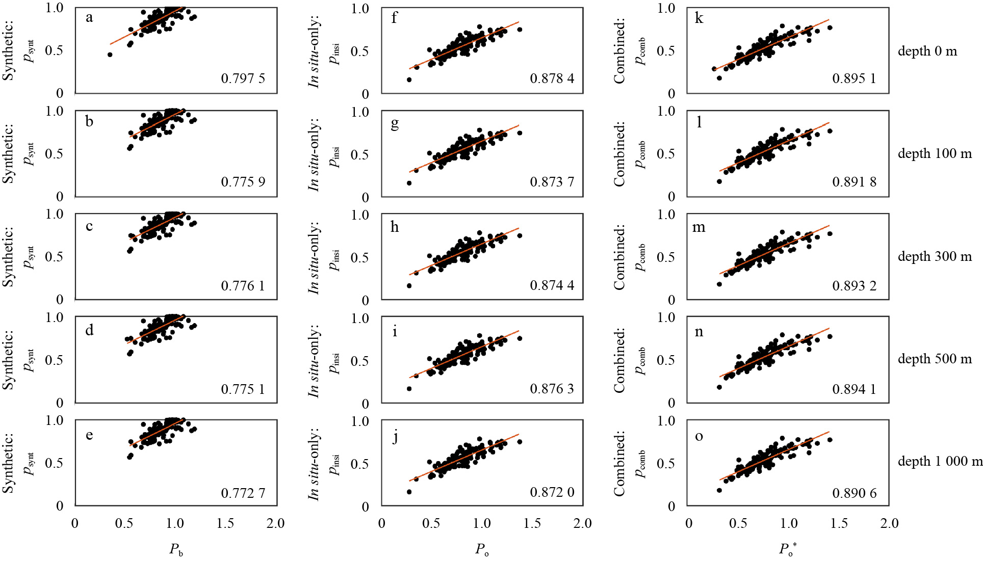
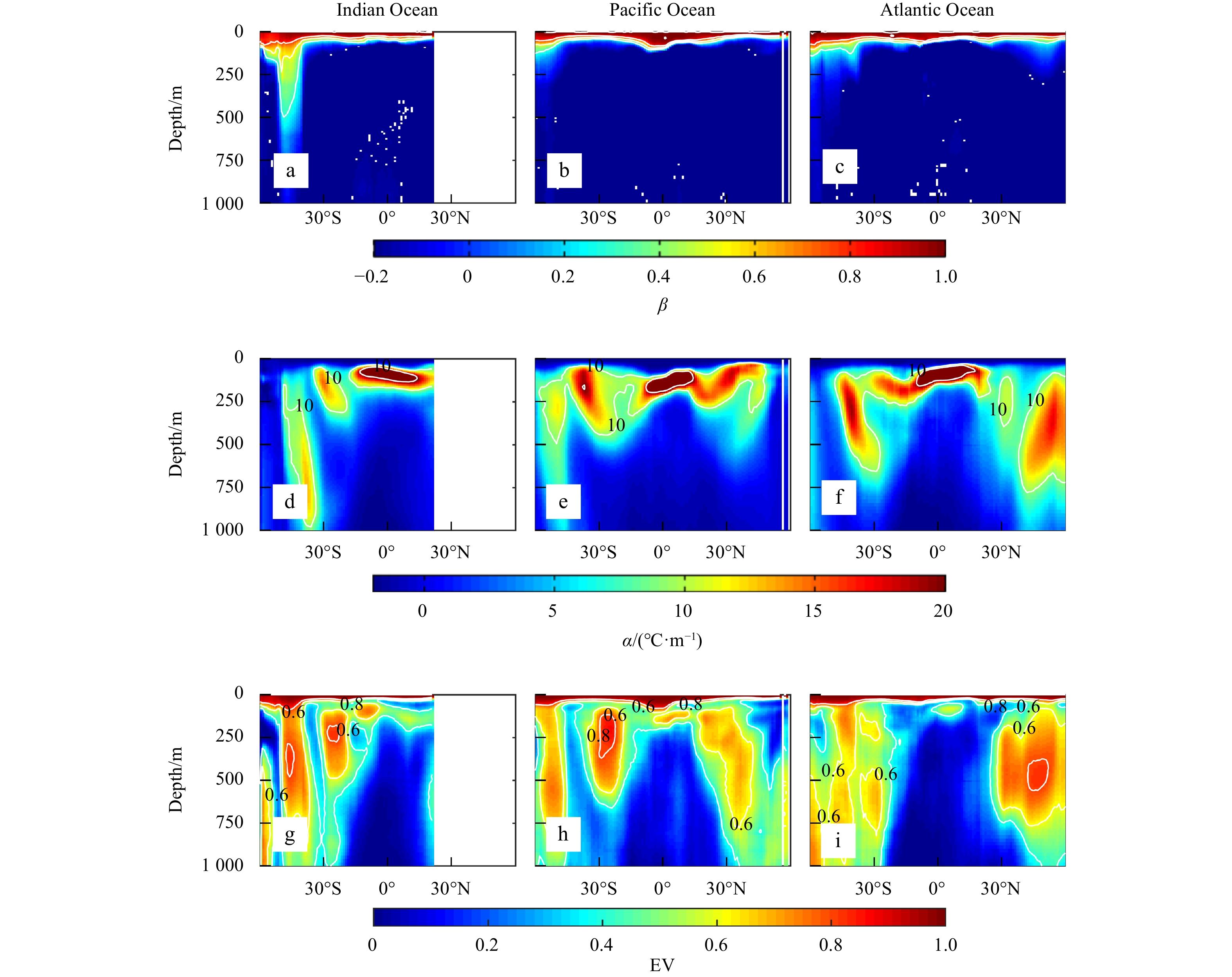
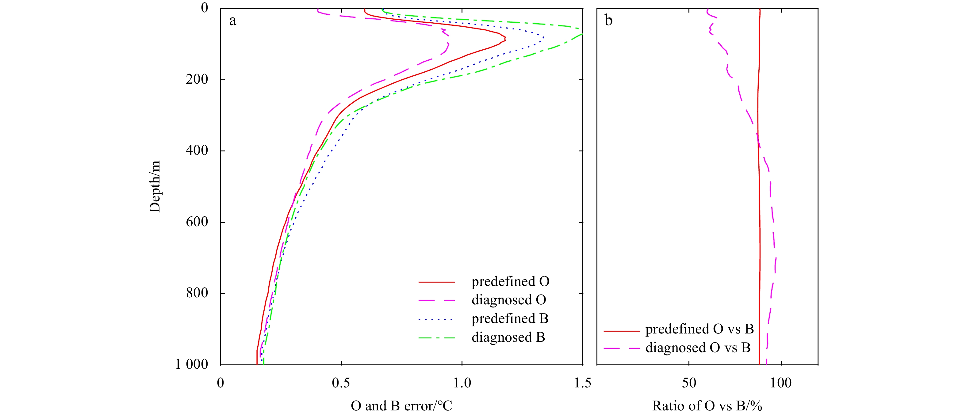
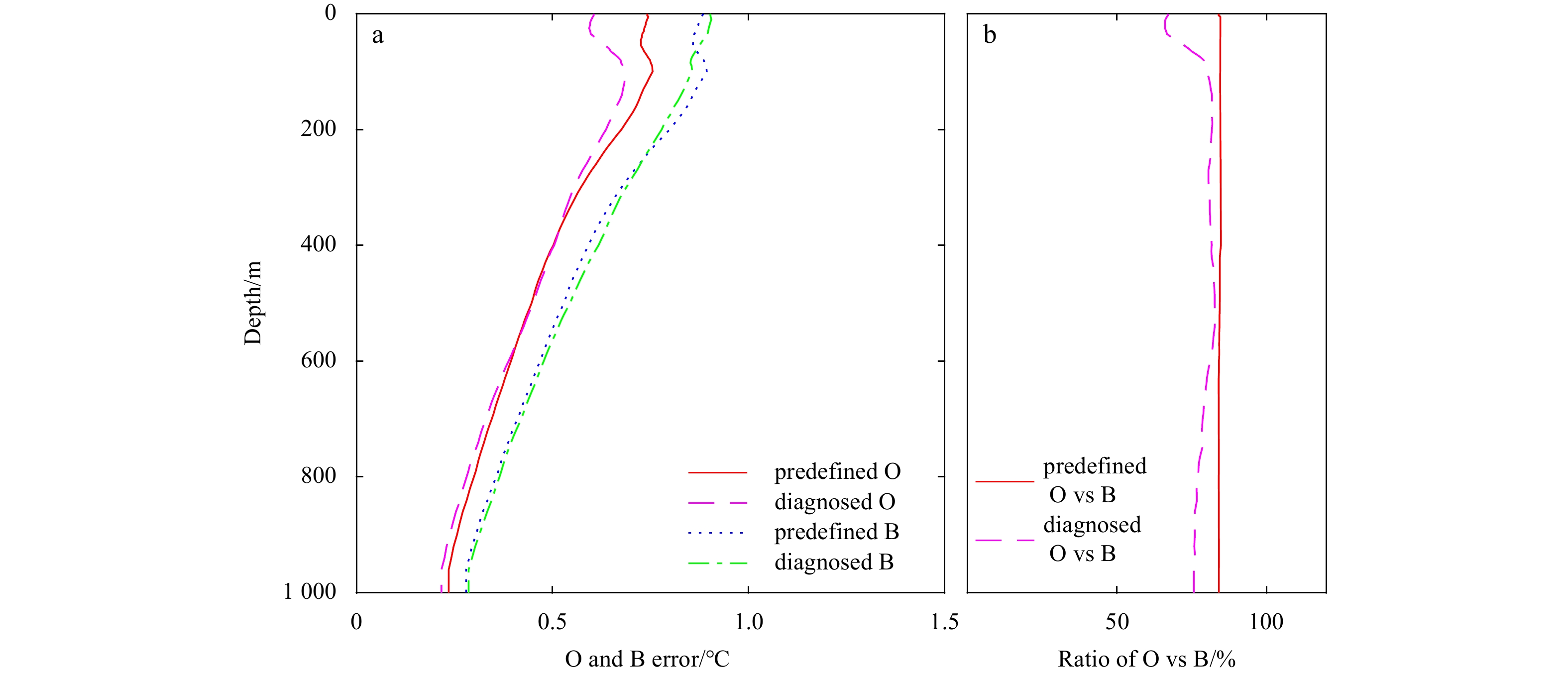
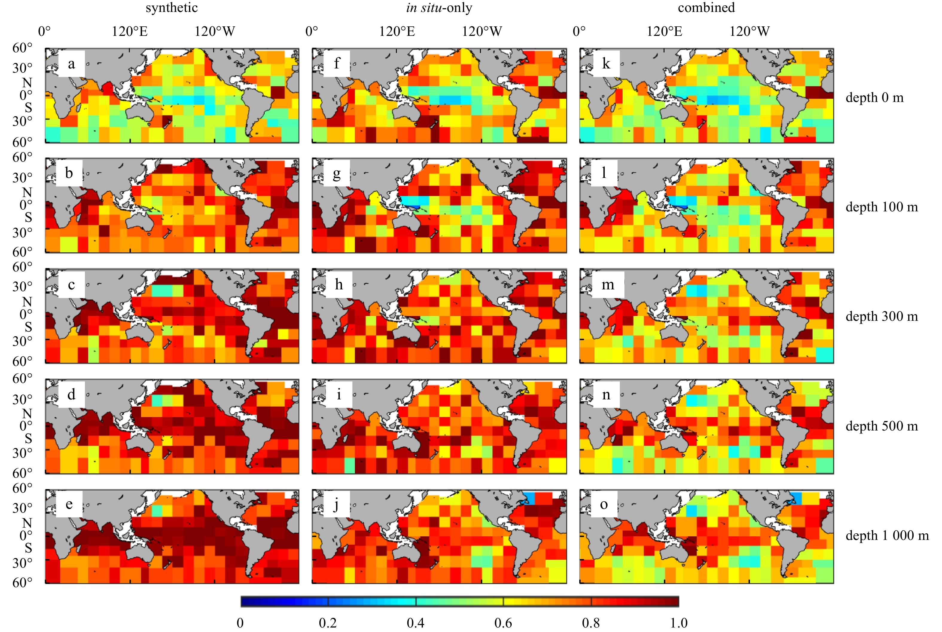
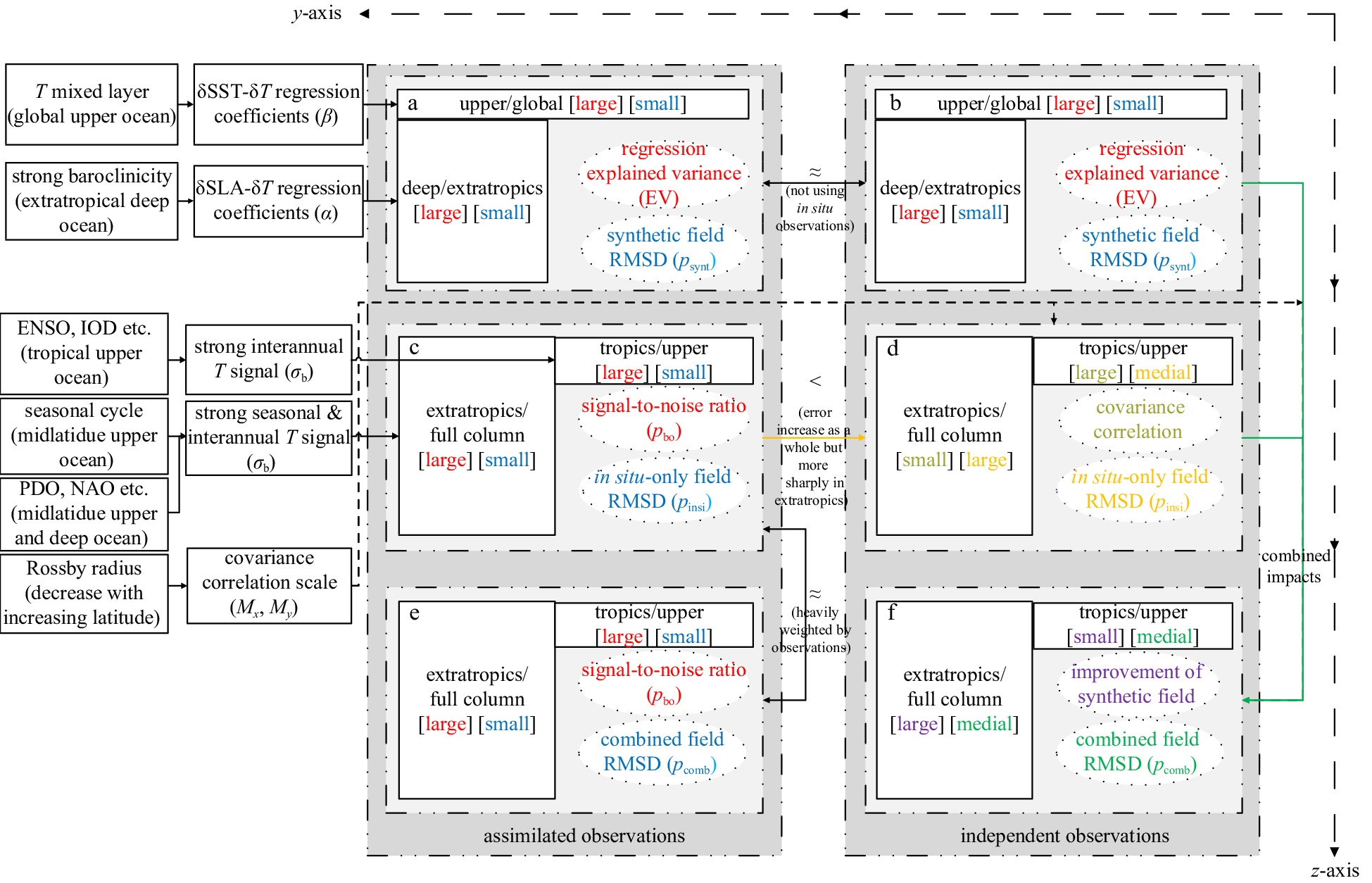
Assimilation systems absorb both satellite measurements and Argo observations. This assimilation is essential to diagnose and evaluate the contribution from each type of data to the reconstructed analysis, allowing for better configuration of assimilation parameters. To achieve this, two comparative reconstruction schemes were designed under the optimal interpolation framework. Using a static scheme, an in situ-only field of ocean temperature was derived by correcting climatology with only Argo profiles. Through a dynamic scheme, a synthetic field was first derived from only satellite sea surface height and sea surface temperature measurements through vertical projection, and then a combined field was reconstructed by correcting the synthetic field with in situ profiles. For both schemes, a diagnostic iterative method was performed to optimize the background and observation error covariance statics. The root mean square difference (RMSD) of the in situ-only field, synthetic field and combined field were analyzed toward assimilated observations and independent observations, respectively. The rationale behind the distribution of RMSD was discussed using the following diagnostics: (1) The synthetic field has a smaller RMSD within the global mixed layer and extratropical deep waters, as in the Northwest Pacific Ocean; this is controlled by the explained variance of the vertical surface-underwater regression that reflects the ocean upper mixing and interior baroclinicity. (2) The in situ-only field has a smaller RMSD in the tropical upper layer and at midlatitudes; this is determined by the actual noise-to-signal ratio of ocean temperature. (3) The satellite observations make a more significant contribution to the analysis toward independent observations in the extratropics; this is determined by both the geographical feature of the synthetic field RMSD (smaller at depth in the extratropics) and that of the covariance correlation scales (smaller in the extratropics).
Assimilation systems absorb both satellite measurements and Argo observations. This assimilation is essential to diagnose and evaluate the contribution from each type of data to the reconstructed analysis, allowing for better configuration of assimilation parameters. To achieve this, two comparative reconstruction schemes were designed under the optimal interpolation framework. Using a static scheme, an in situ-only field of ocean temperature was derived by correcting climatology with only Argo profiles. Through a dynamic scheme, a synthetic field was first derived from only satellite sea surface height and sea surface temperature measurements through vertical projection, and then a combined field was reconstructed by correcting the synthetic field with in situ profiles. For both schemes, a diagnostic iterative method was performed to optimize the background and observation error covariance statics. The root mean square difference (RMSD) of the in situ-only field, synthetic field and combined field were analyzed toward assimilated observations and independent observations, respectively. The rationale behind the distribution of RMSD was discussed using the following diagnostics: (1) The synthetic field has a smaller RMSD within the global mixed layer and extratropical deep waters, as in the Northwest Pacific Ocean; this is controlled by the explained variance of the vertical surface-underwater regression that reflects the ocean upper mixing and interior baroclinicity. (2) The in situ-only field has a smaller RMSD in the tropical upper layer and at midlatitudes; this is determined by the actual noise-to-signal ratio of ocean temperature. (3) The satellite observations make a more significant contribution to the analysis toward independent observations in the extratropics; this is determined by both the geographical feature of the synthetic field RMSD (smaller at depth in the extratropics) and that of the covariance correlation scales (smaller in the extratropics).


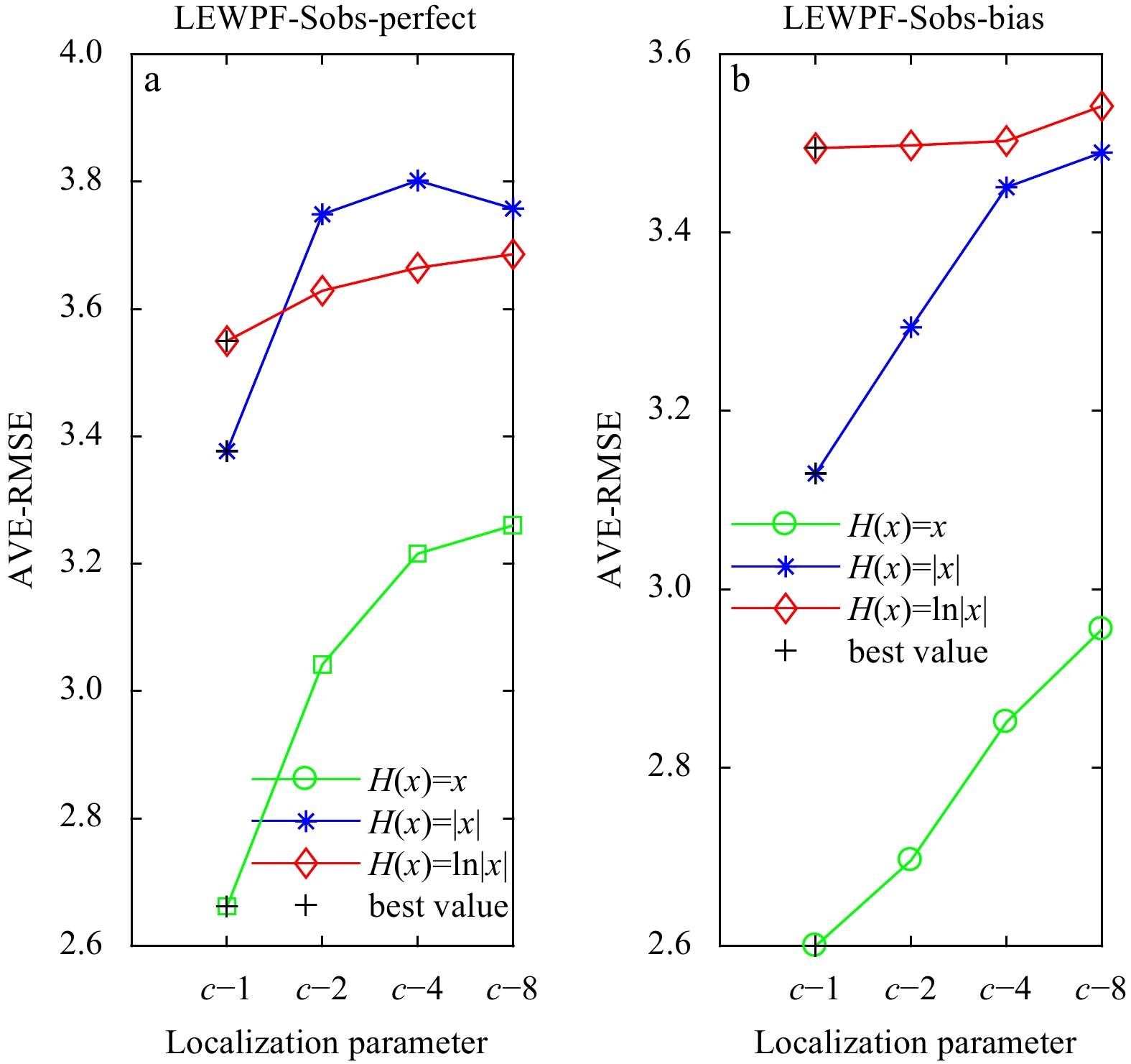
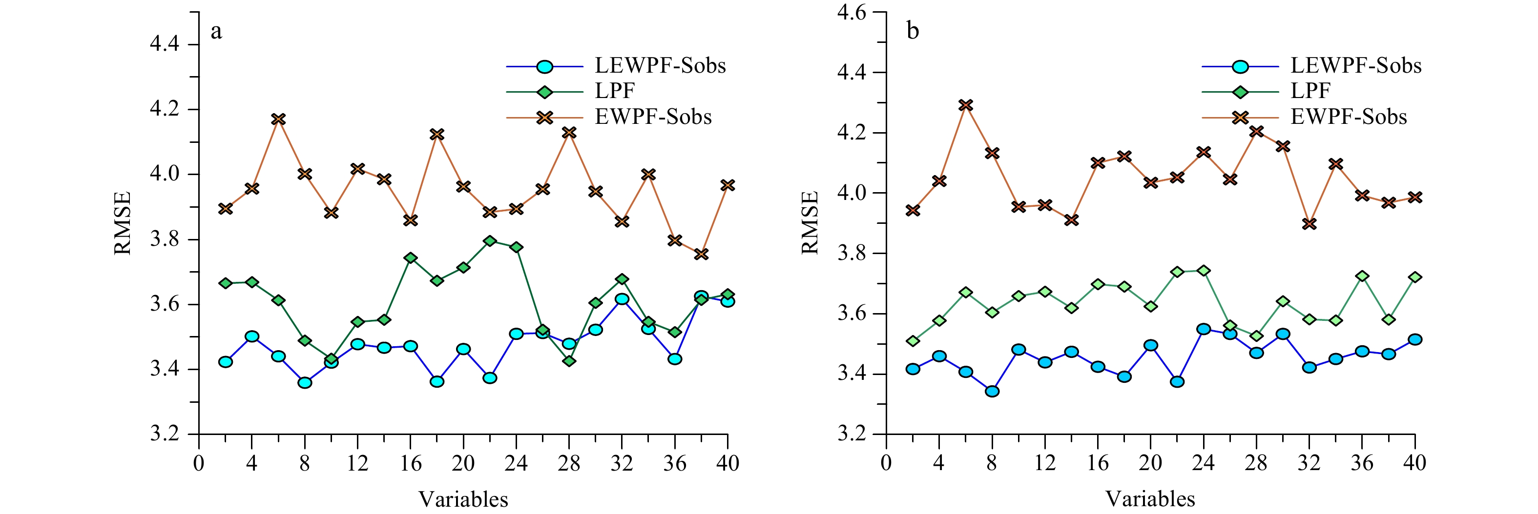
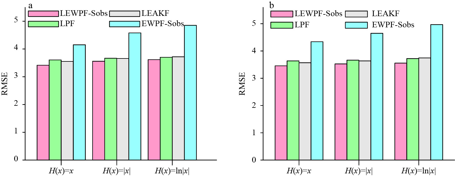
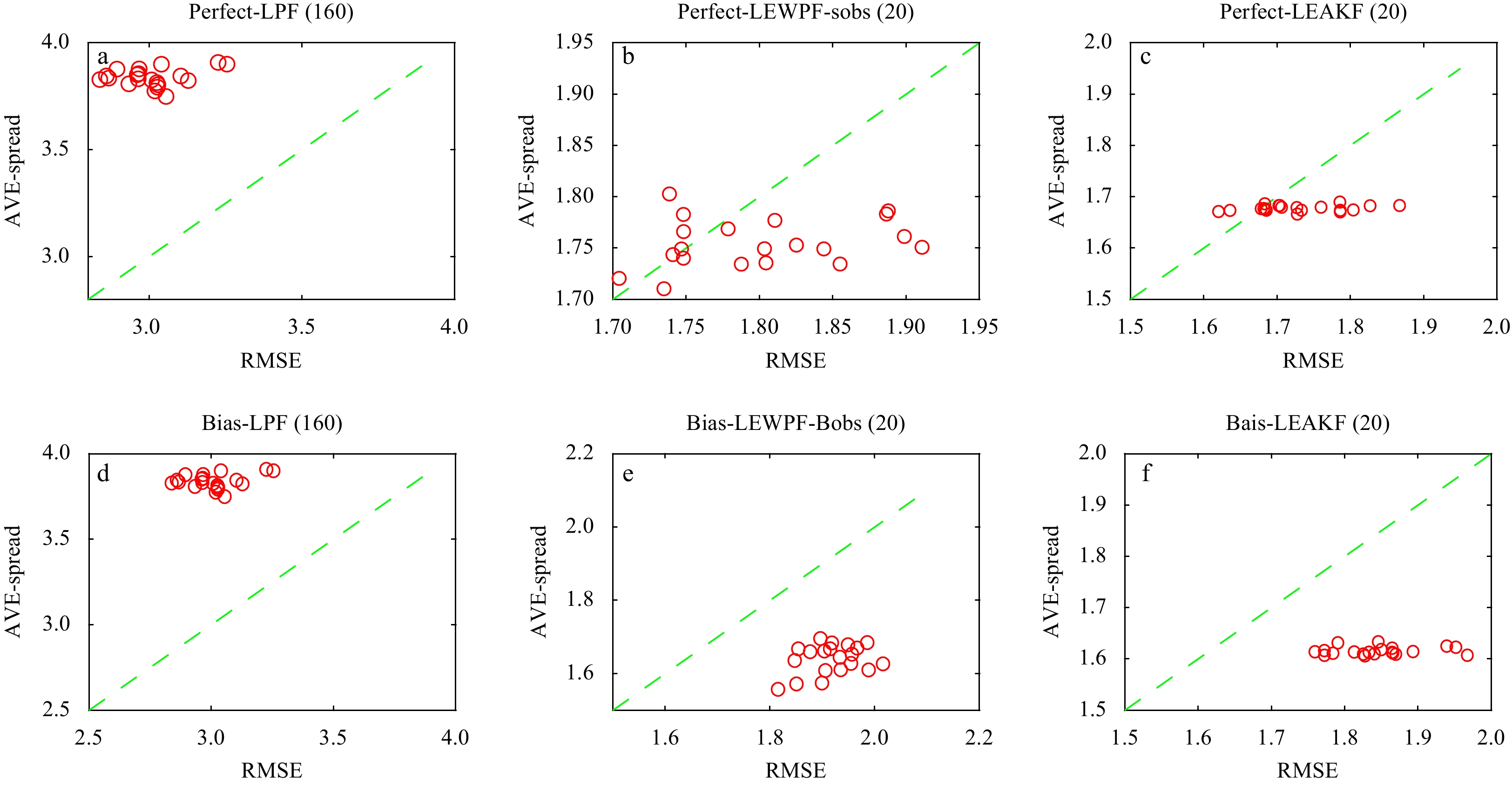
The statistical observation localized equivalent-weights particle filter in a simple nonlinear model
2022, 41(2): 80-90.
doi: 10.1007/s13131-021-1876-1
Abstract:
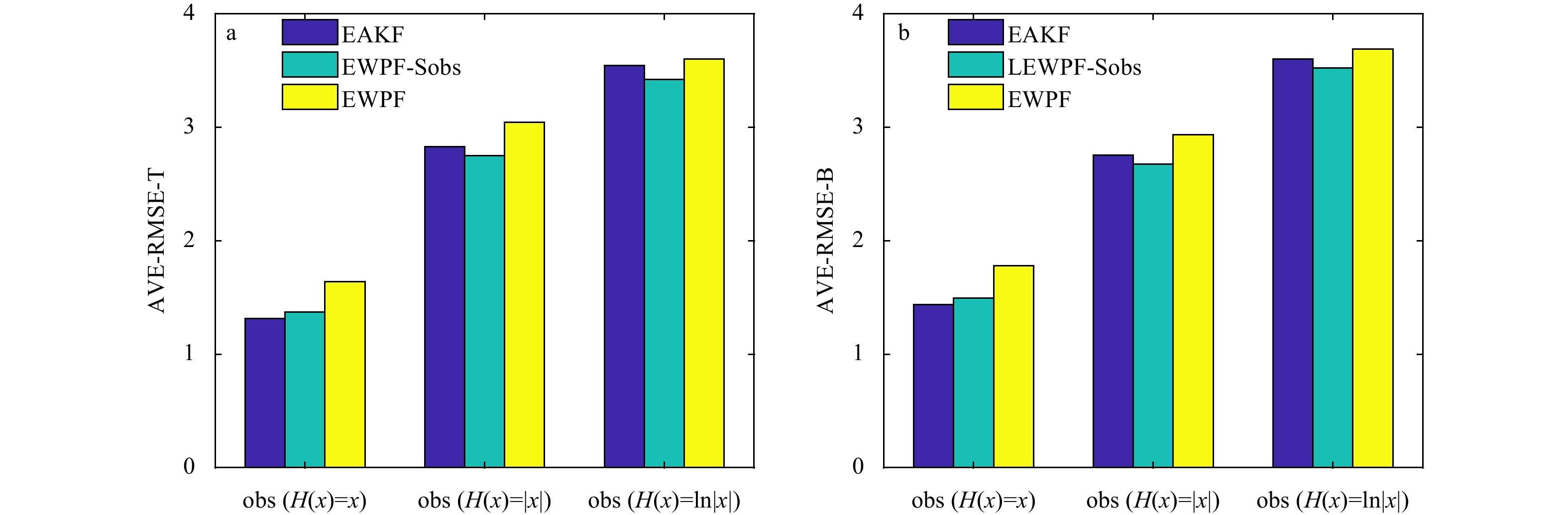
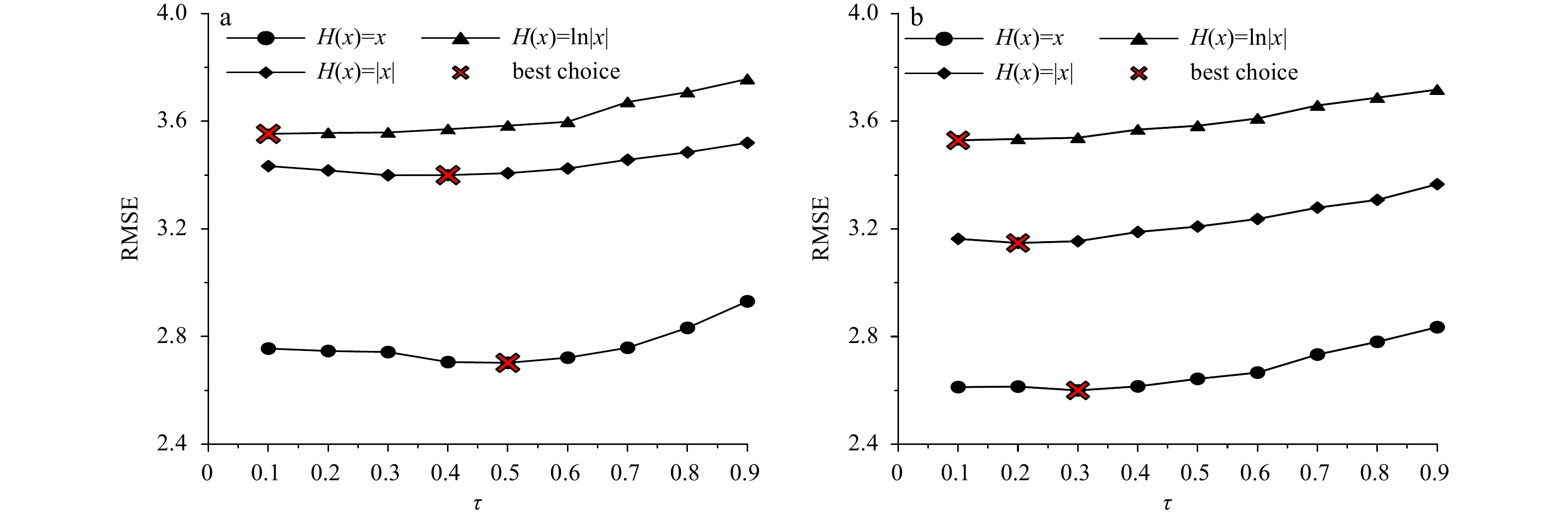
This paper presents an improved approach based on the equivalent-weights particle filter (EWPF) that uses the proposal density to effectively improve the traditional particle filter. The proposed approach uses historical data to calculate statistical observations instead of the future observations used in the EWPF’s proposal density and draws on the localization scheme used in the localized PF (LPF) to construct the localized EWPF. The new approach is called the statistical observation localized EWPF (LEWPF-Sobs); it uses statistical observations that are better adapted to the requirements of real-time assimilation and the localization function is used to calculate weights to reduce the effect of missing observations on the weights. This approach not only retains the advantages of the EWPF, but also improves the assimilation quality when using sparse observations. Numerical experiments performed with the Lorenz 96 model show that the statistical observation EWPF is better than the EWPF and EAKF when the model uses standard distribution observations. Comparisons of the statistical observation localized EWPF and LPF reveal the advantages of the new method, with fewer particles giving better results. In particular, the new improved filter performs better than the traditional algorithms when the observation network contains densely spaced measurements associated with model state nonlinearities.
This paper presents an improved approach based on the equivalent-weights particle filter (EWPF) that uses the proposal density to effectively improve the traditional particle filter. The proposed approach uses historical data to calculate statistical observations instead of the future observations used in the EWPF’s proposal density and draws on the localization scheme used in the localized PF (LPF) to construct the localized EWPF. The new approach is called the statistical observation localized EWPF (LEWPF-Sobs); it uses statistical observations that are better adapted to the requirements of real-time assimilation and the localization function is used to calculate weights to reduce the effect of missing observations on the weights. This approach not only retains the advantages of the EWPF, but also improves the assimilation quality when using sparse observations. Numerical experiments performed with the Lorenz 96 model show that the statistical observation EWPF is better than the EWPF and EAKF when the model uses standard distribution observations. Comparisons of the statistical observation localized EWPF and LPF reveal the advantages of the new method, with fewer particles giving better results. In particular, the new improved filter performs better than the traditional algorithms when the observation network contains densely spaced measurements associated with model state nonlinearities.


2022, 41(2): 91-102.
doi: 10.1007/s13131-021-1856-5
Abstract:
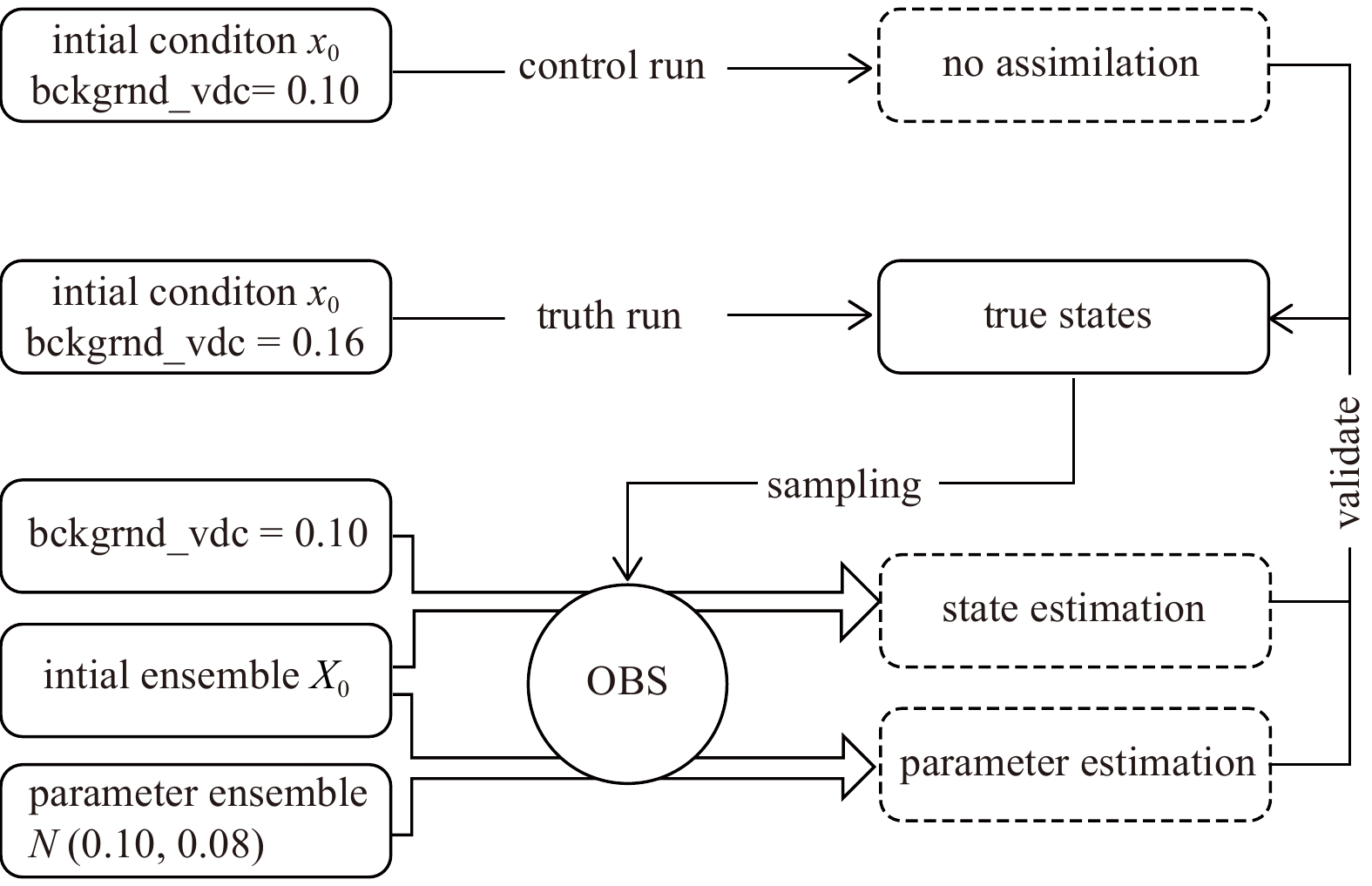
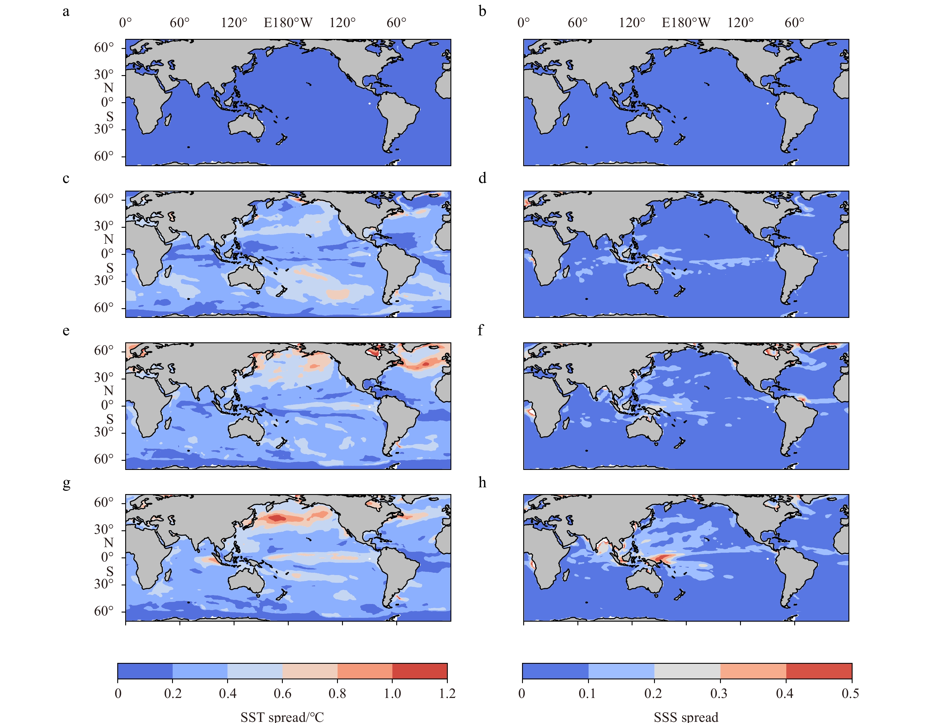
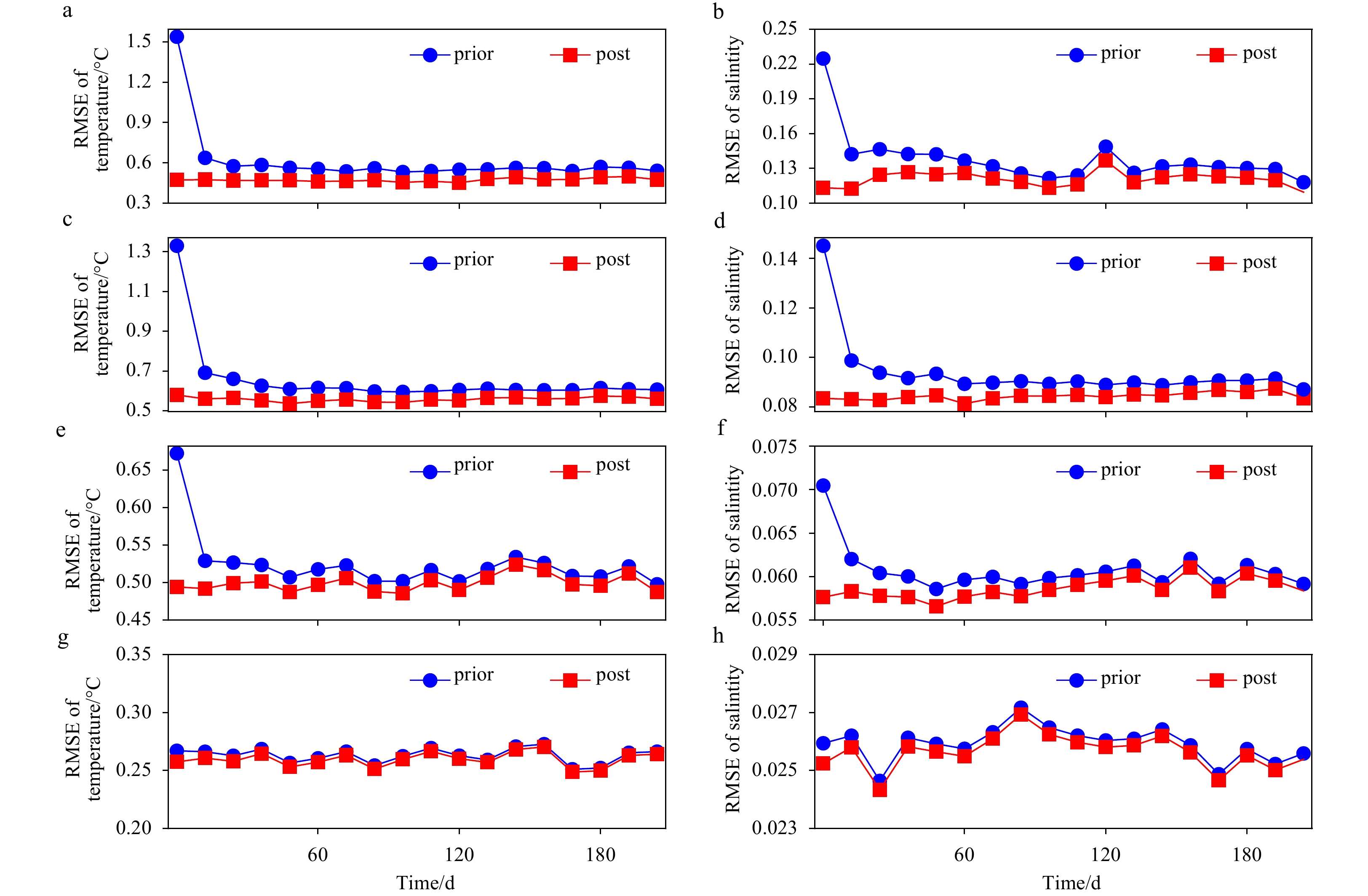
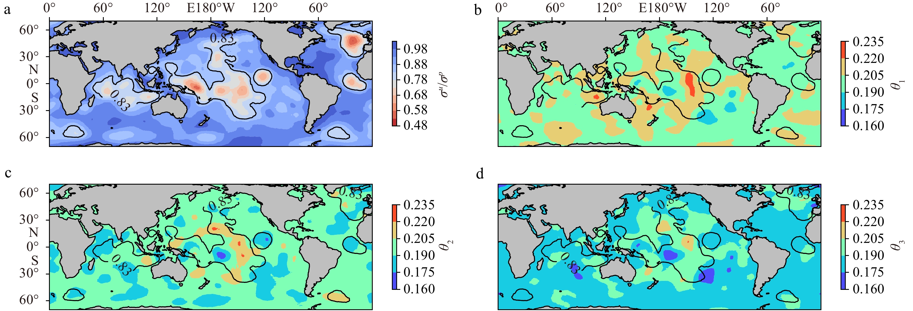
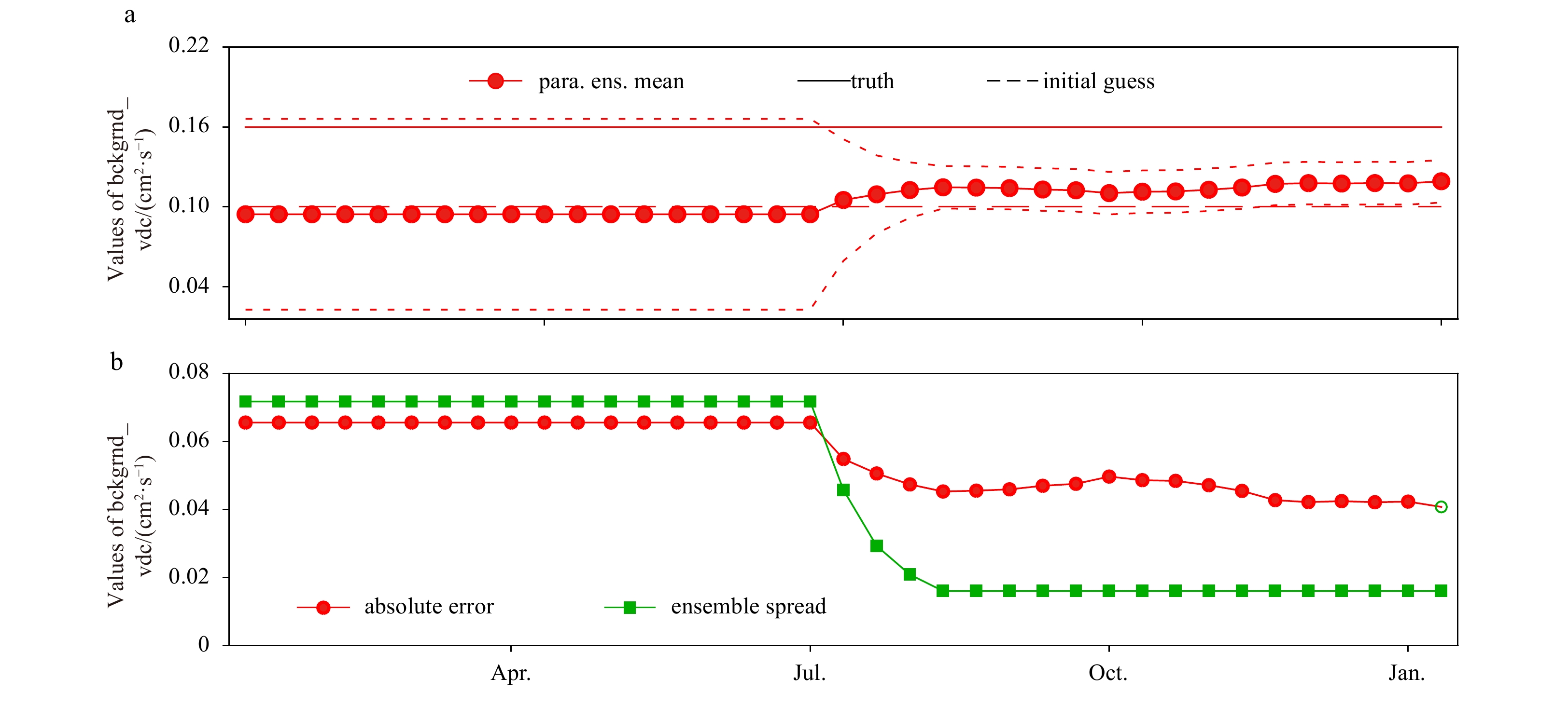
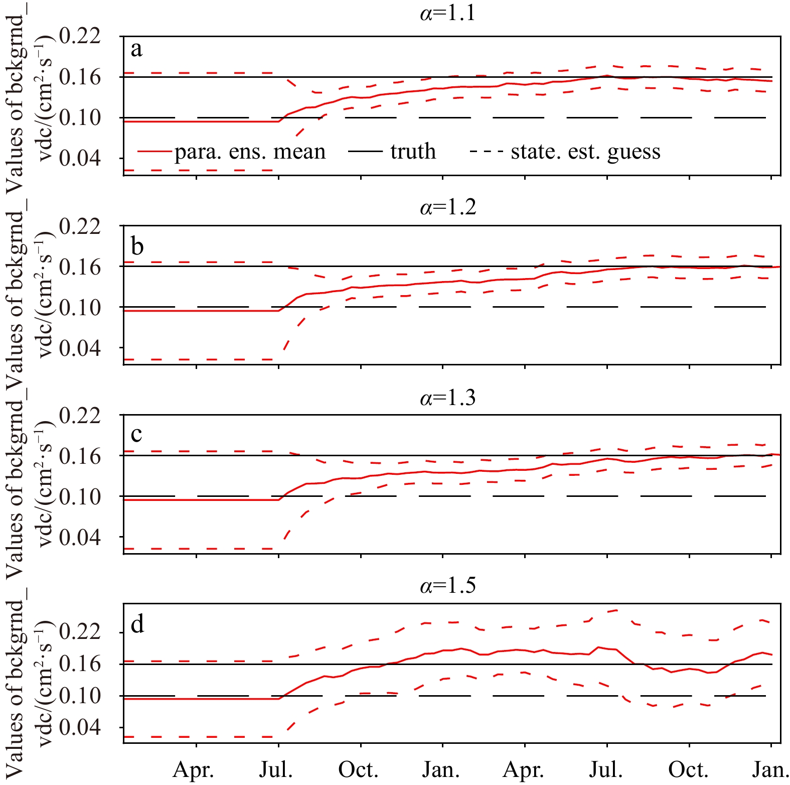
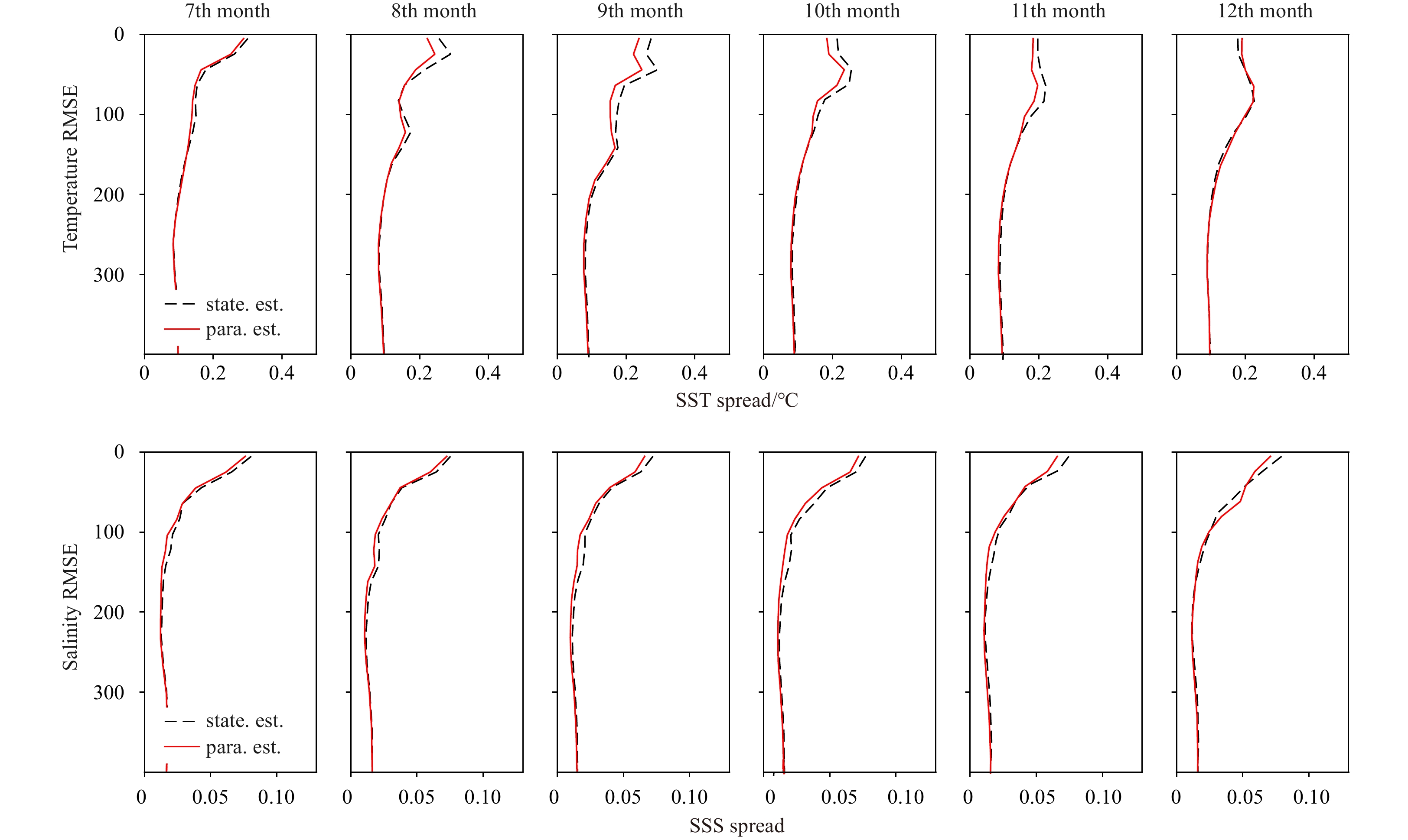
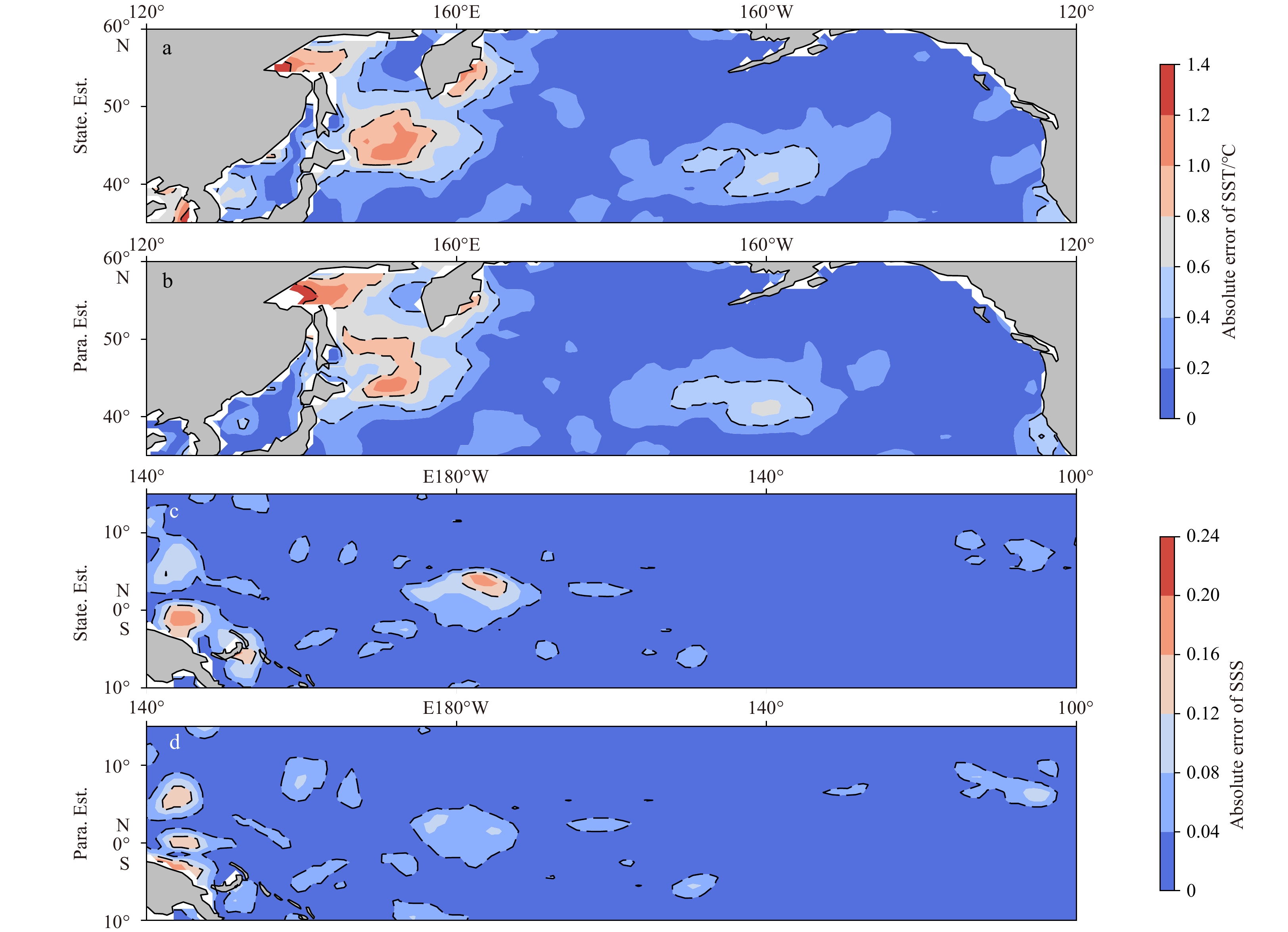
Parameter estimation is defined as the process to adjust or optimize the model parameter using observations. A long-term problem in ensemble-based parameter estimation methods is that the parameters are assumed to be constant during model integration. This assumption will cause underestimation of parameter ensemble spread, such that the parameter ensemble tends to collapse before an optimal solution is found. In this work, a two-stage inflation method is developed for parameter estimation, which can address the collapse of parameter ensemble due to the constant evolution of parameters. In the first stage, adaptive inflation is applied to the augmented states, in which the global scalar parameter is transformed to fields with spatial dependence. In the second stage, extra multiplicative inflation is used to inflate the scalar parameter ensemble to compensate for constant parameter evolution, where the inflation factor is determined according to the spread growth ratio of model states. The observation system simulation experiment with Community Earth System Model (CESM) shows that the second stage of the inflation scheme plays a crucial role in successful parameter estimation. With proper multiplicative inflation factors, the parameter estimation can effectively reduce the parameter biases, providing more accurate analyses.
Parameter estimation is defined as the process to adjust or optimize the model parameter using observations. A long-term problem in ensemble-based parameter estimation methods is that the parameters are assumed to be constant during model integration. This assumption will cause underestimation of parameter ensemble spread, such that the parameter ensemble tends to collapse before an optimal solution is found. In this work, a two-stage inflation method is developed for parameter estimation, which can address the collapse of parameter ensemble due to the constant evolution of parameters. In the first stage, adaptive inflation is applied to the augmented states, in which the global scalar parameter is transformed to fields with spatial dependence. In the second stage, extra multiplicative inflation is used to inflate the scalar parameter ensemble to compensate for constant parameter evolution, where the inflation factor is determined according to the spread growth ratio of model states. The observation system simulation experiment with Community Earth System Model (CESM) shows that the second stage of the inflation scheme plays a crucial role in successful parameter estimation. With proper multiplicative inflation factors, the parameter estimation can effectively reduce the parameter biases, providing more accurate analyses.


2022, 41(2): 103-115.
doi: 10.1007/s13131-021-1940-x
Abstract:
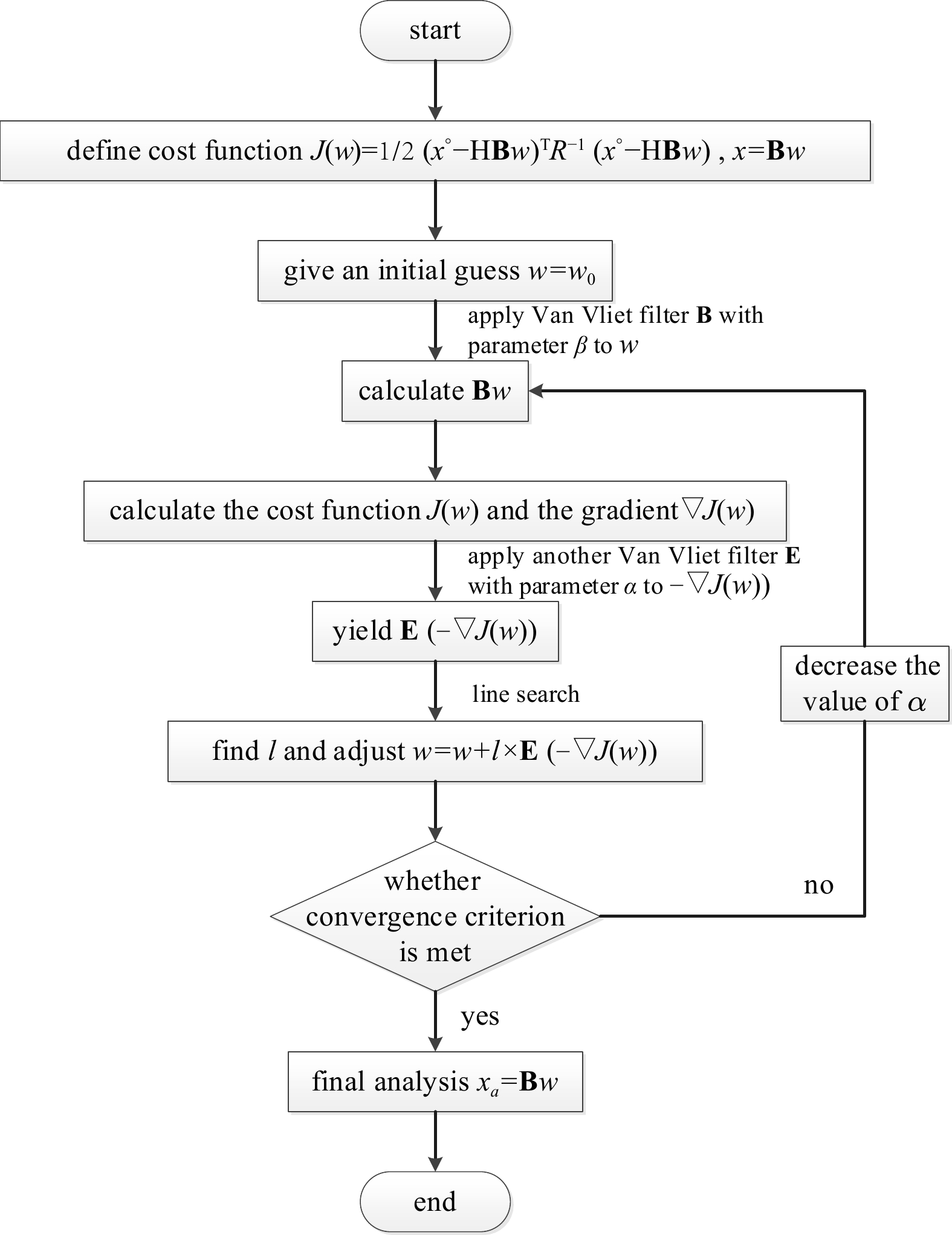
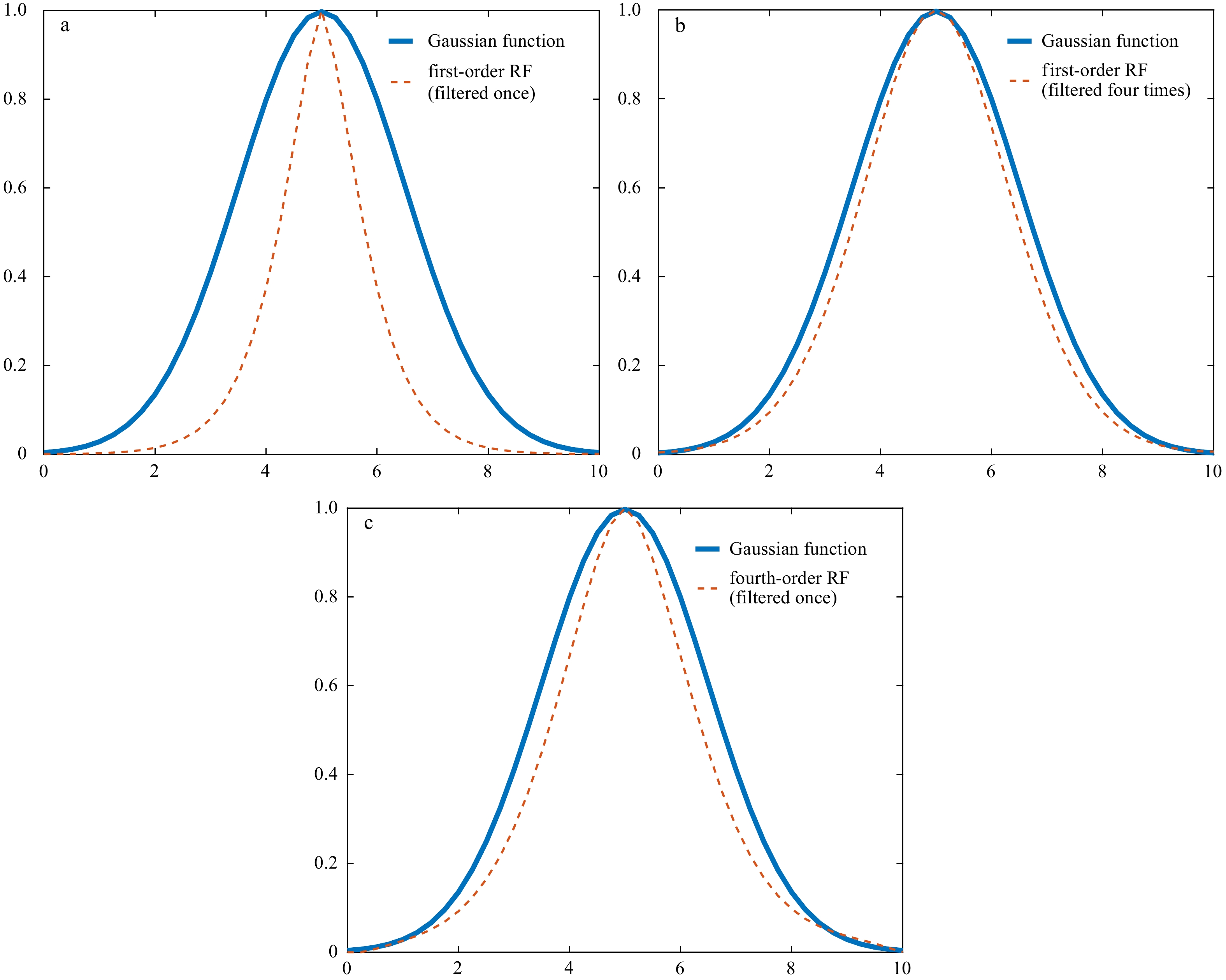
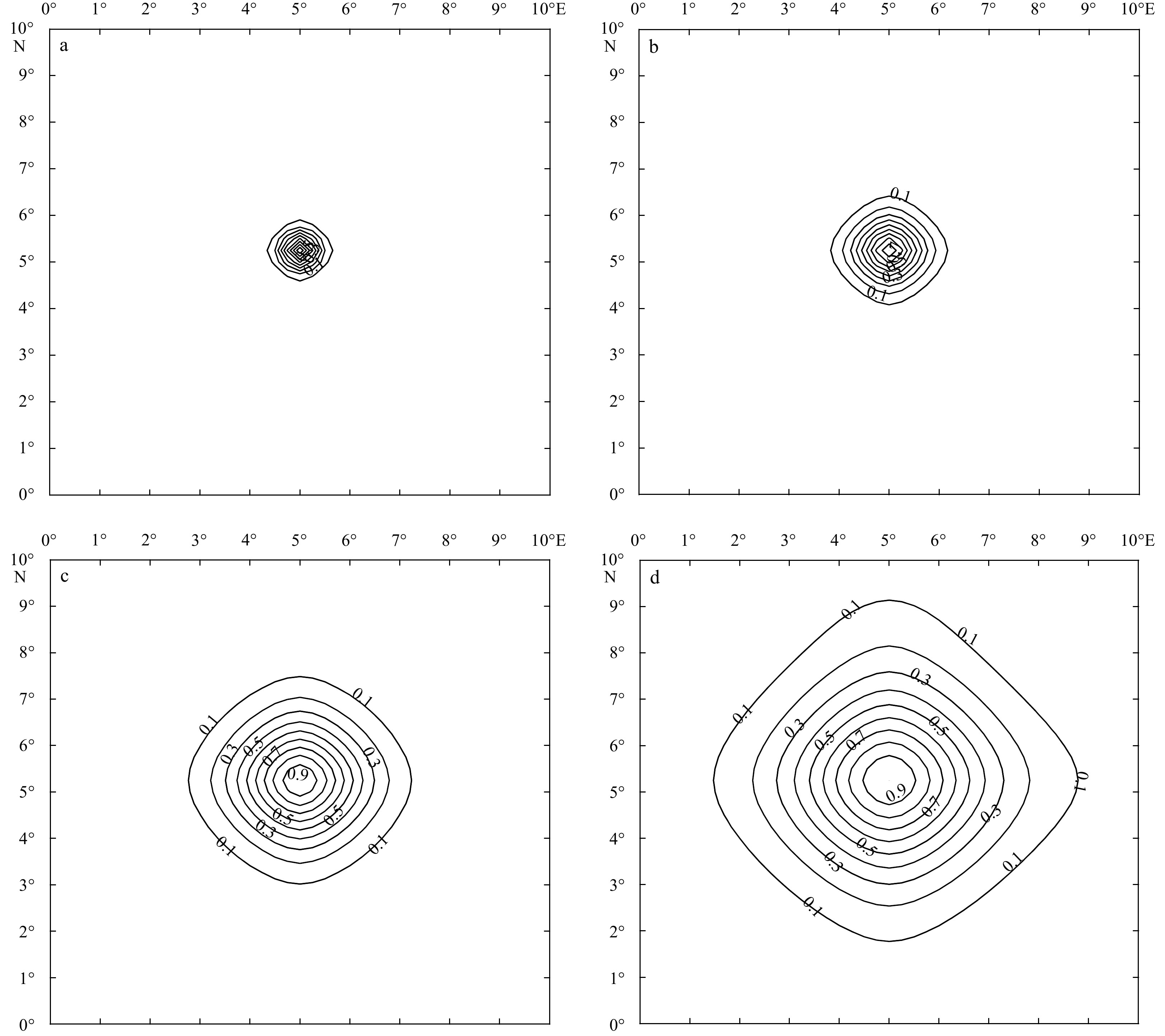
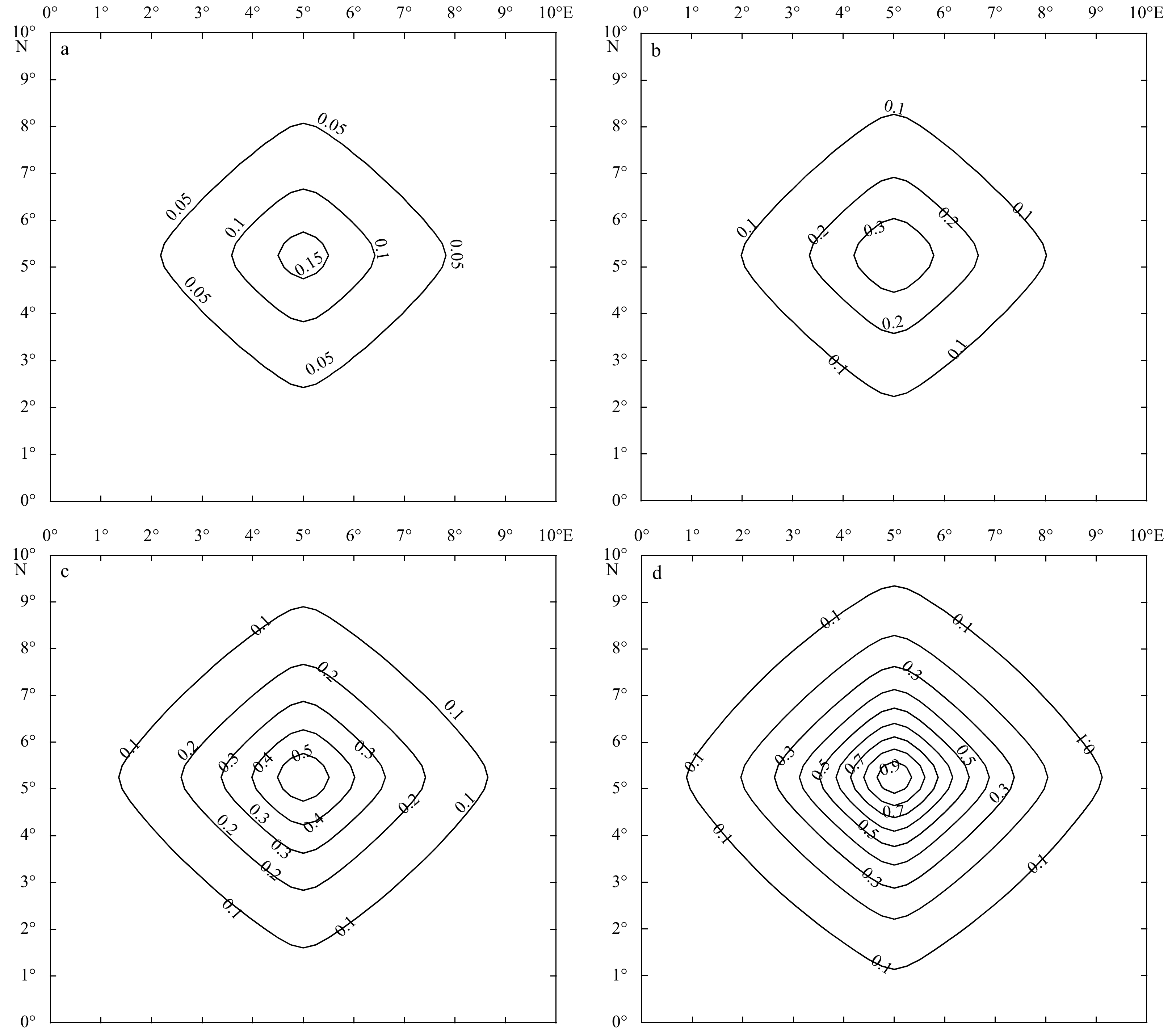
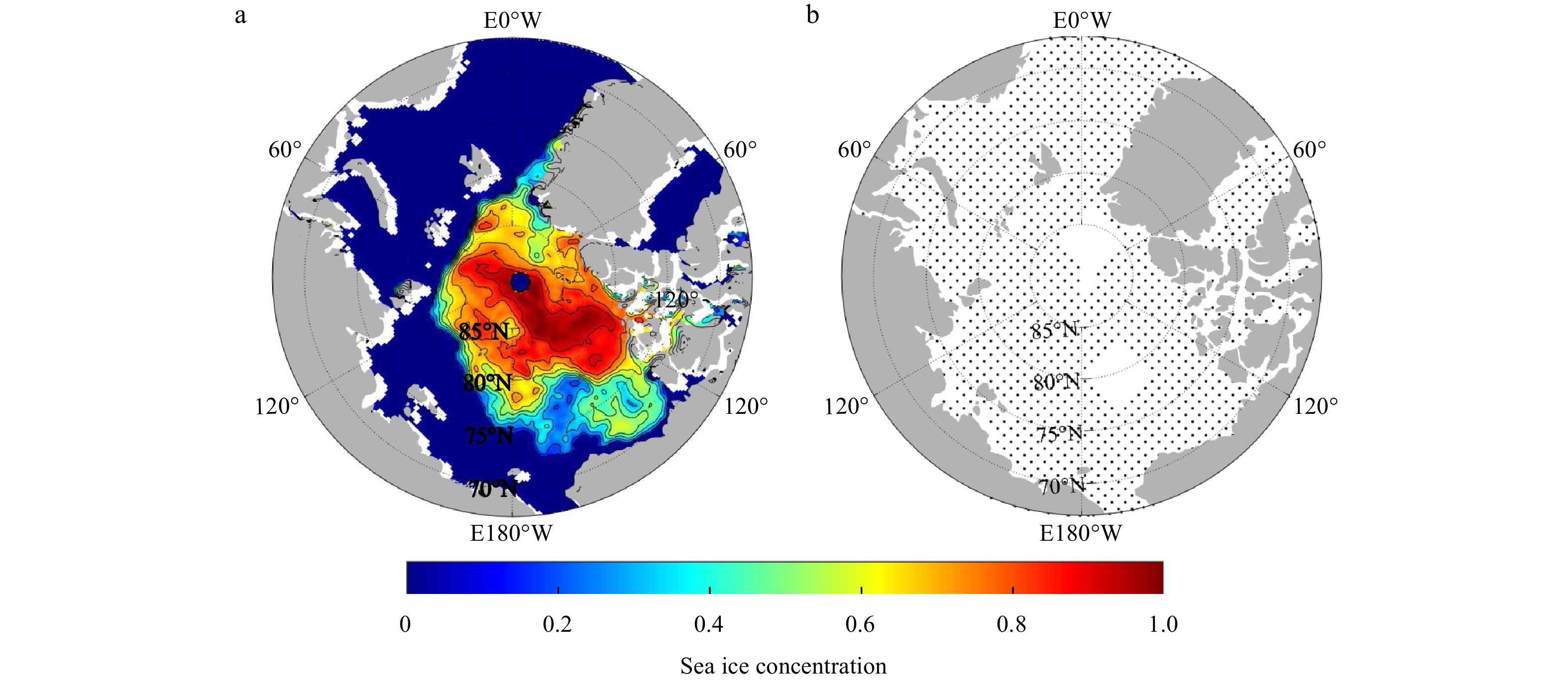
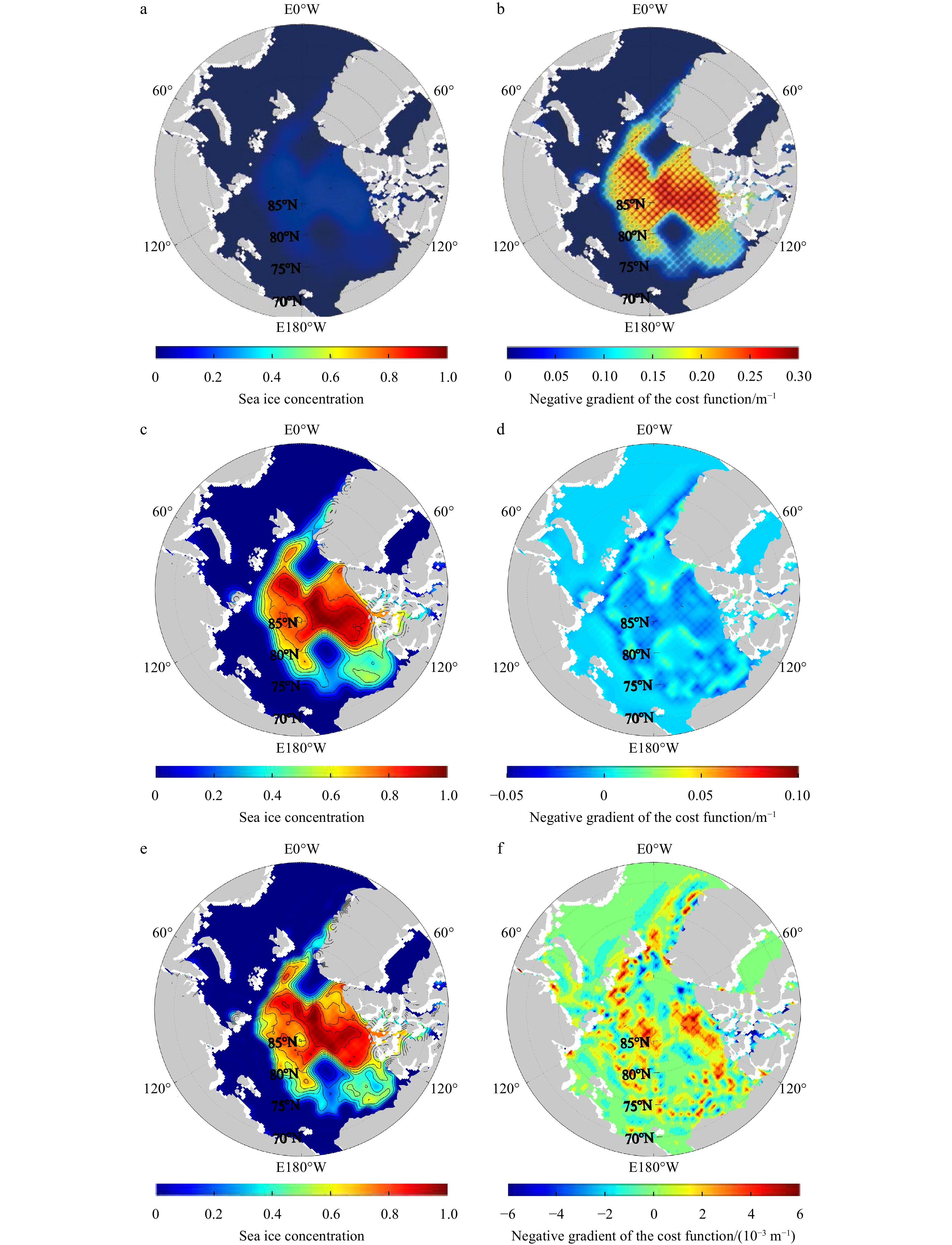
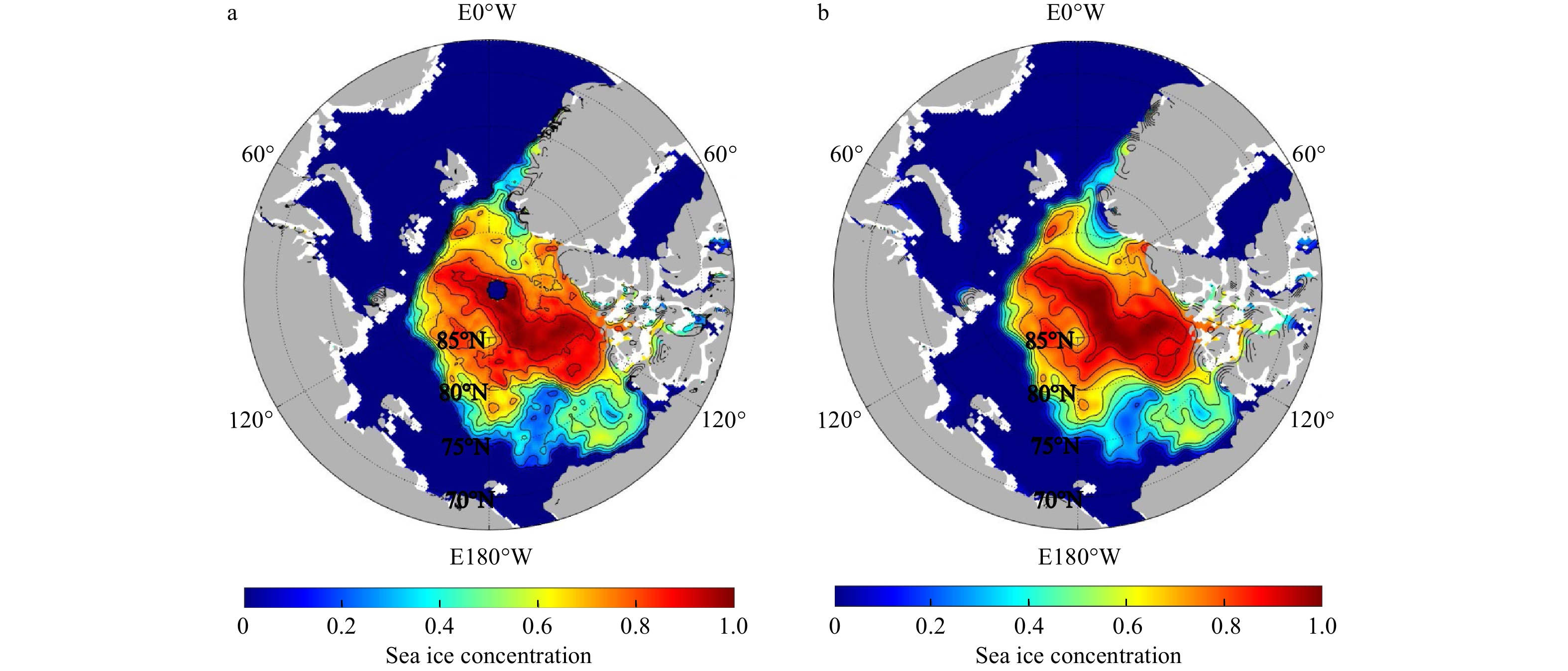
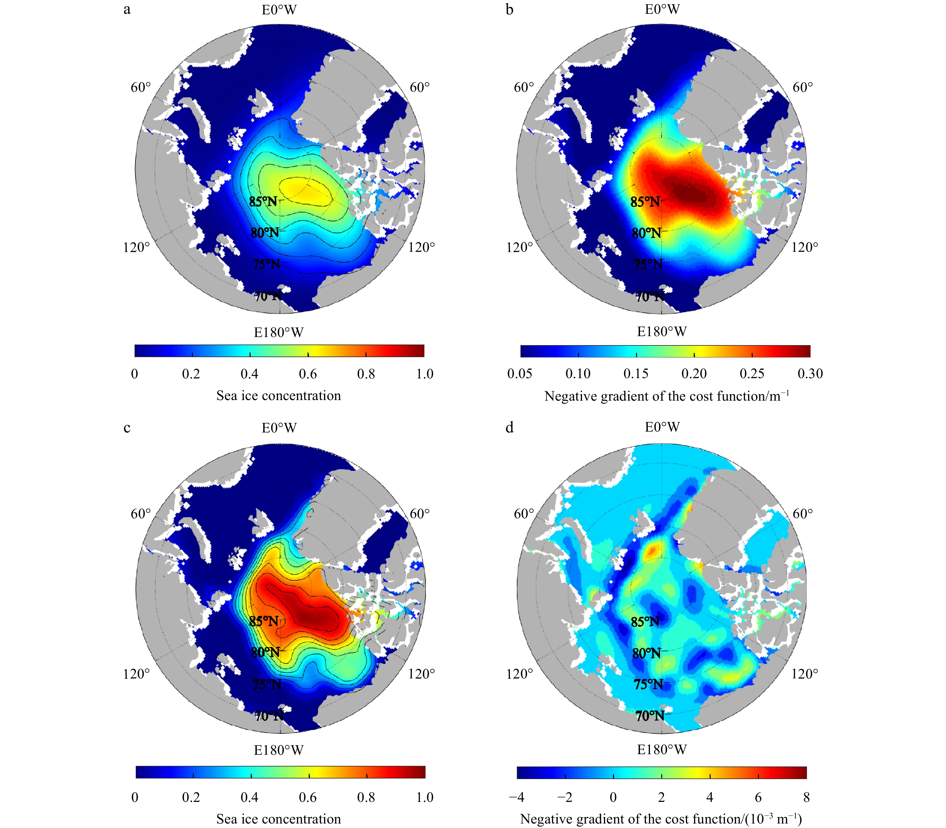
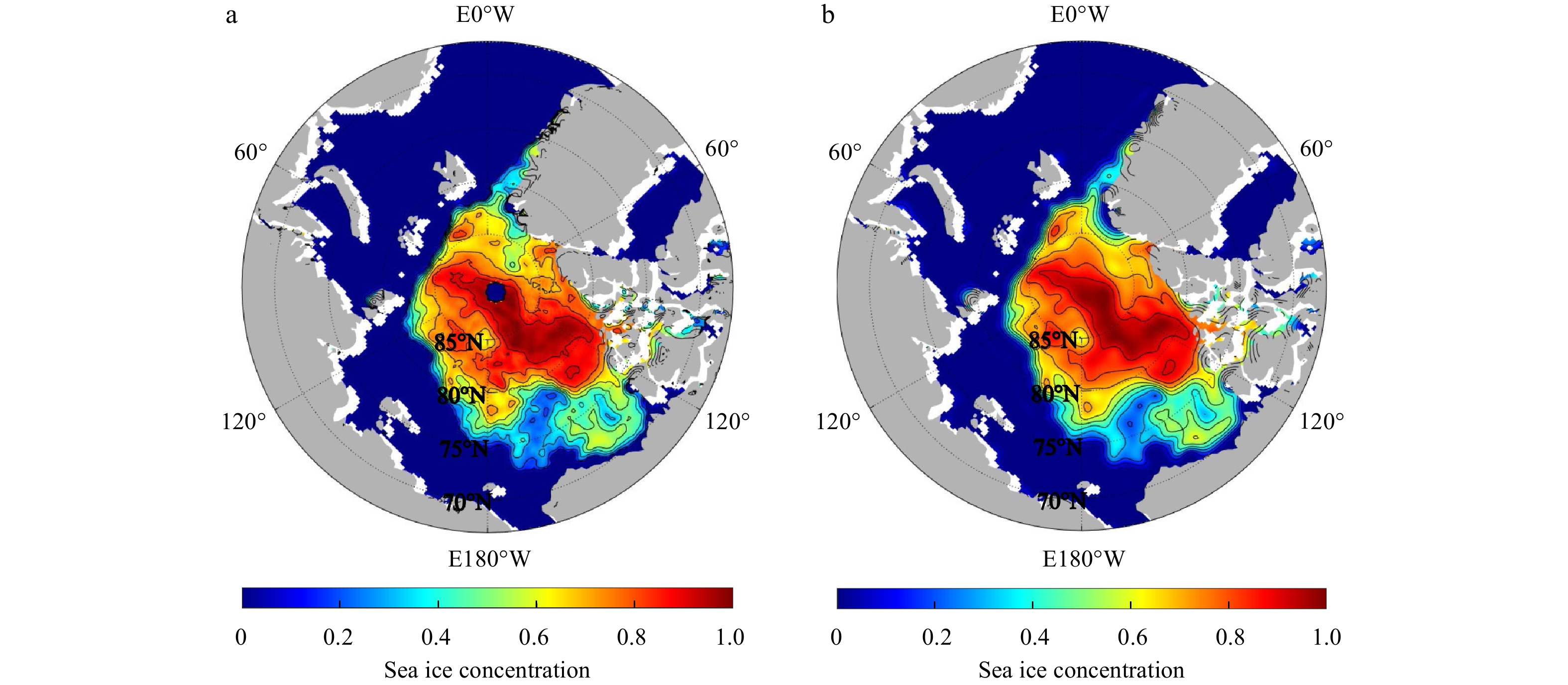
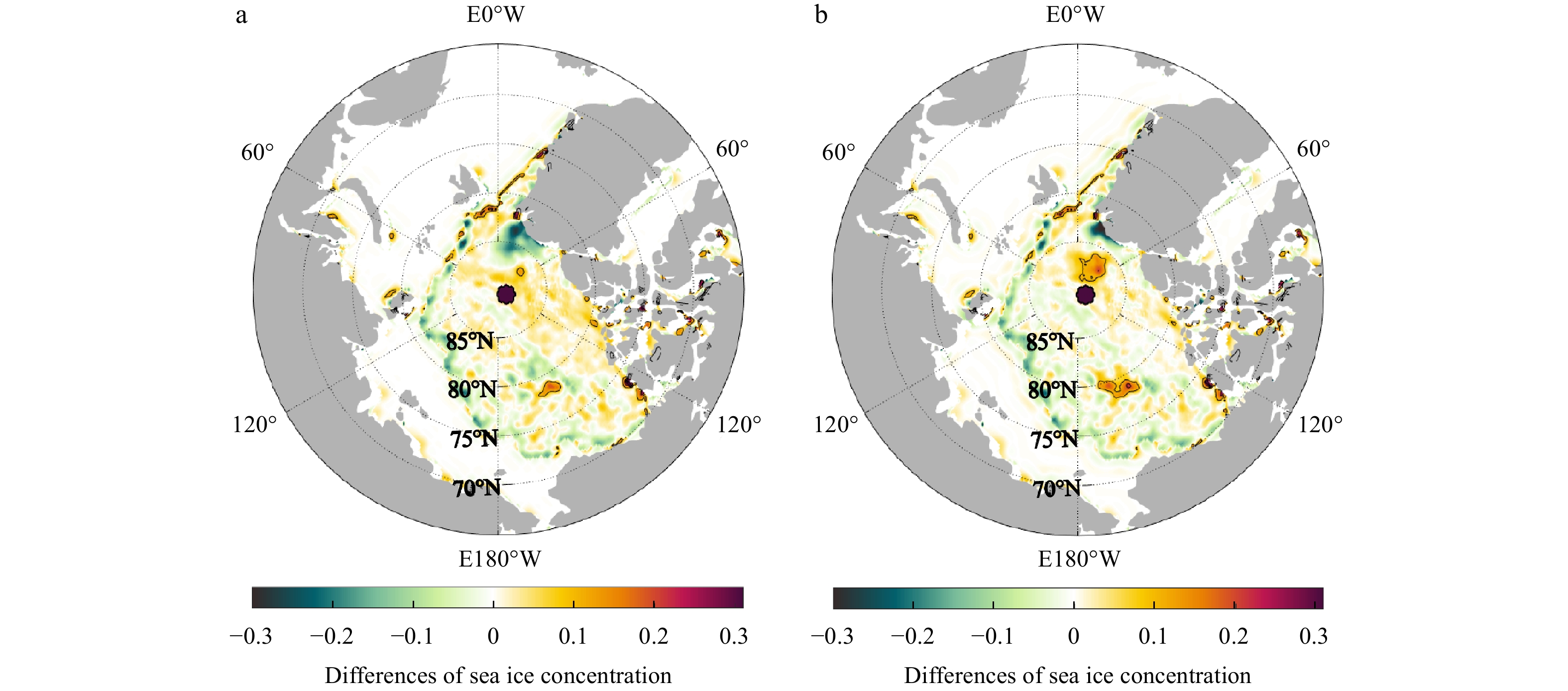
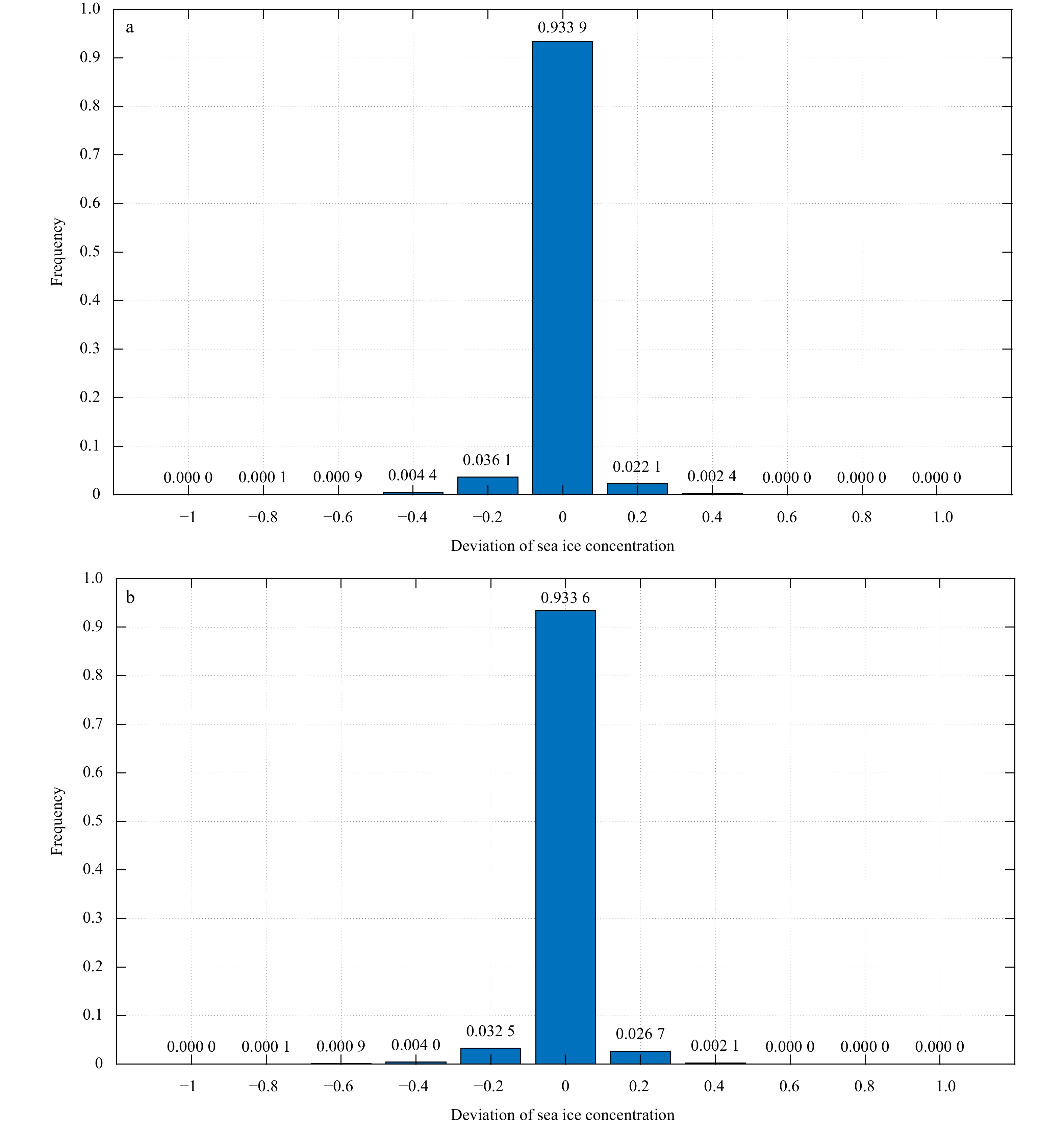
With the development and deployment of observation systems in the ocean, more precise passive and active microwave data are becoming available for the weather forecasting and the climate monitoring. Due to the complicated variability of the sea ice concentration (SIC) in the marginal ice zone and the scarcity of high-precision sea ice data, how to use less data to accurately reconstruct the sea ice field has become an urgent problem to be solved. A reconstruction method for gridding observations using the variational optimization technique, called the multi-scale high-order recursive filter (MHRF), which is a combination of Van Vliet fourth-order recursive filter and the three-dimensional variational (3D-VAR) analysis, has been designed in this study to reproduce the refined structure of sea ice field. Compared with the existing spatial multi-scale first-order recursive filter (SMRF) in which left and right filter iterative processes are executed many times, the MHRF scheme only executes the same filter process once to reduce the analysis errors caused by multiple filters and improve the filter precision. Furthermore, the series connected transfer function in the high-order recursive filter is equivalently replaced by the paralleled one, which can carry out the independent filter process in every direction in order to improve the filter efficiency. Experimental results demonstrate that this method possesses a good potential in extracting the observation information to successfully reconstruct the SIC field in computational efficiency.
With the development and deployment of observation systems in the ocean, more precise passive and active microwave data are becoming available for the weather forecasting and the climate monitoring. Due to the complicated variability of the sea ice concentration (SIC) in the marginal ice zone and the scarcity of high-precision sea ice data, how to use less data to accurately reconstruct the sea ice field has become an urgent problem to be solved. A reconstruction method for gridding observations using the variational optimization technique, called the multi-scale high-order recursive filter (MHRF), which is a combination of Van Vliet fourth-order recursive filter and the three-dimensional variational (3D-VAR) analysis, has been designed in this study to reproduce the refined structure of sea ice field. Compared with the existing spatial multi-scale first-order recursive filter (SMRF) in which left and right filter iterative processes are executed many times, the MHRF scheme only executes the same filter process once to reduce the analysis errors caused by multiple filters and improve the filter precision. Furthermore, the series connected transfer function in the high-order recursive filter is equivalently replaced by the paralleled one, which can carry out the independent filter process in every direction in order to improve the filter efficiency. Experimental results demonstrate that this method possesses a good potential in extracting the observation information to successfully reconstruct the SIC field in computational efficiency.


2022, 41(2): 116-126.
doi: 10.1007/s13131-021-1895-y
Abstract:
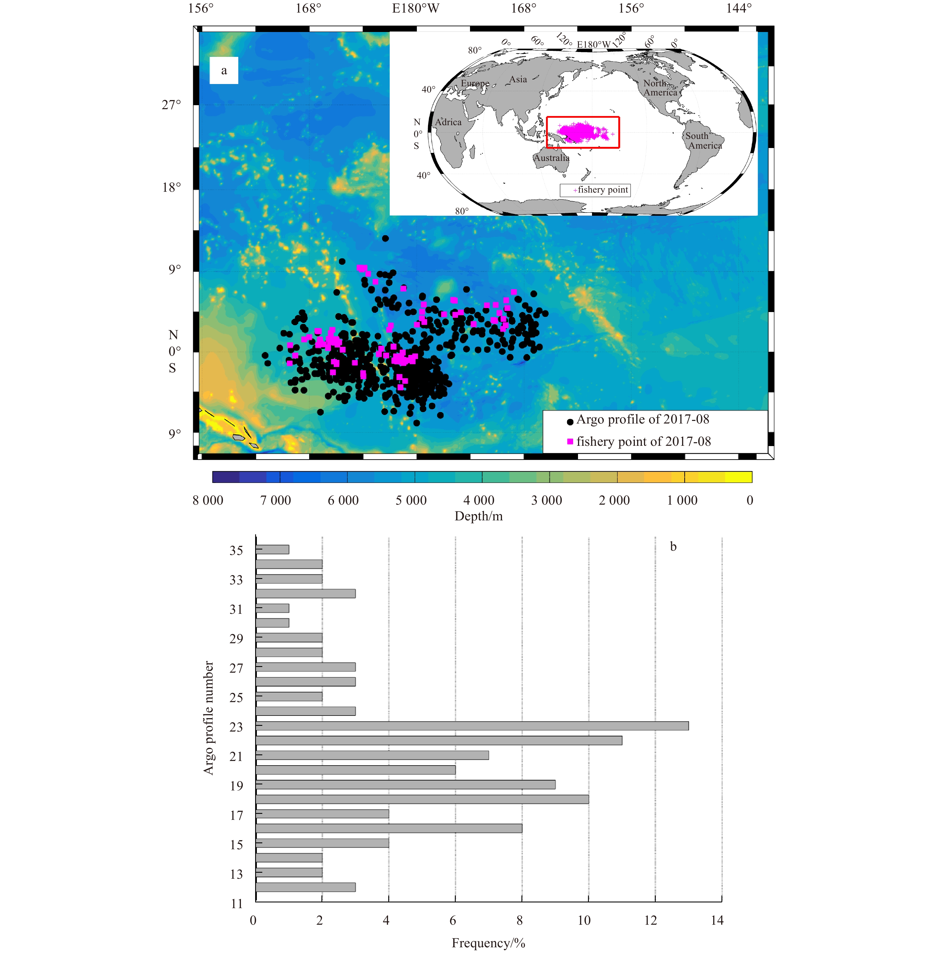
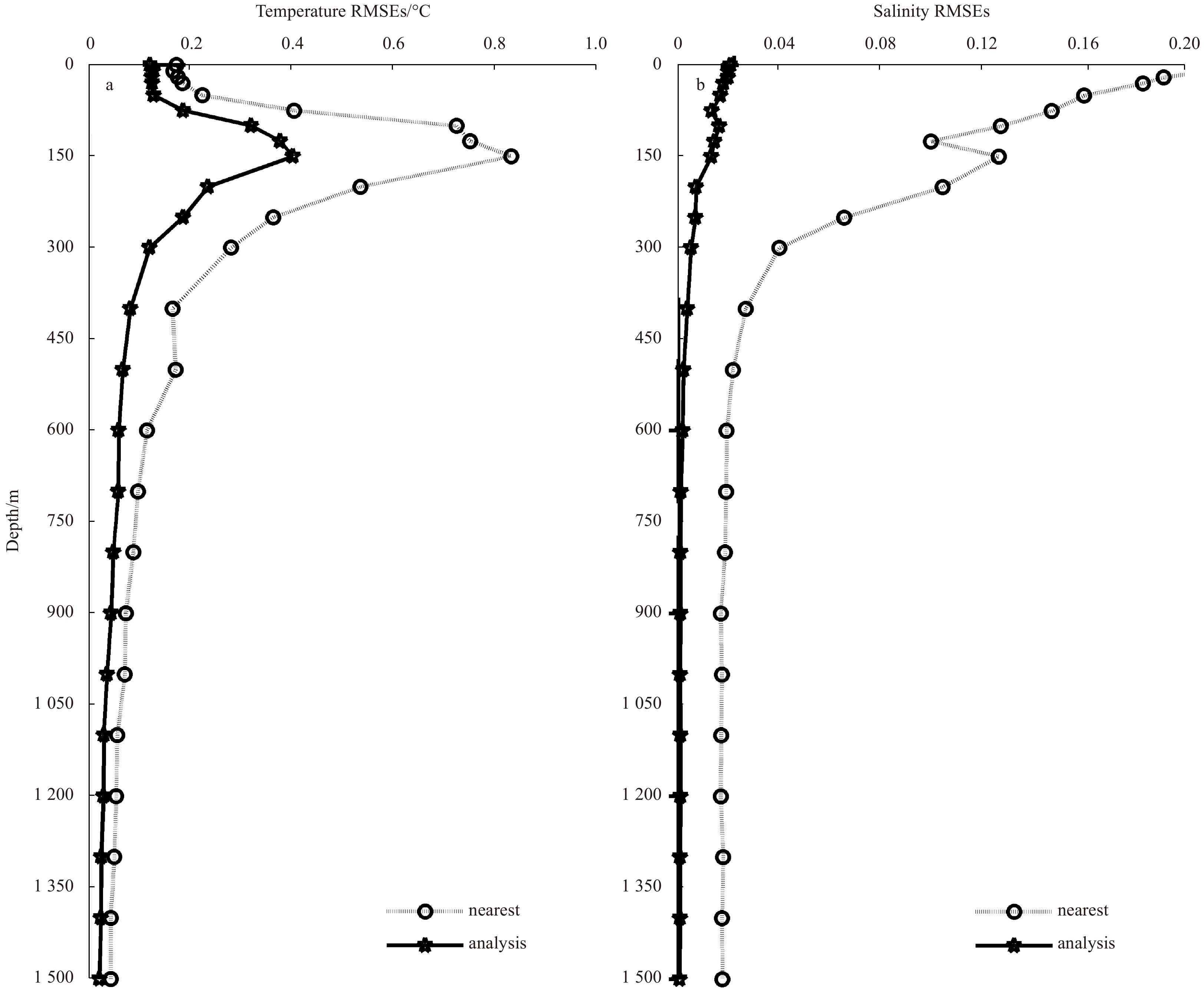
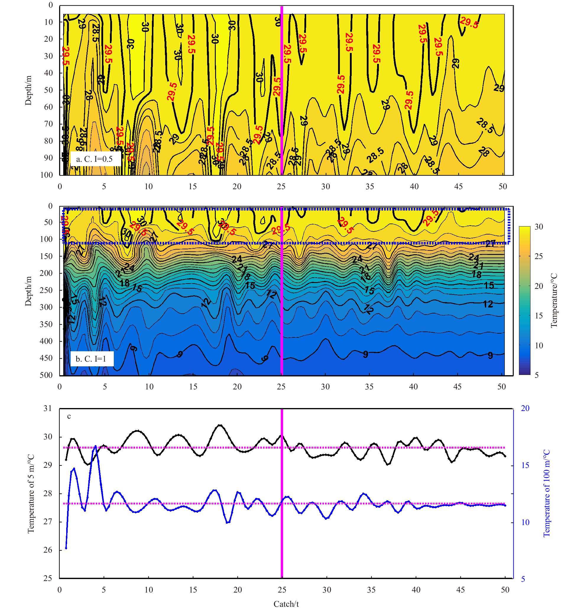
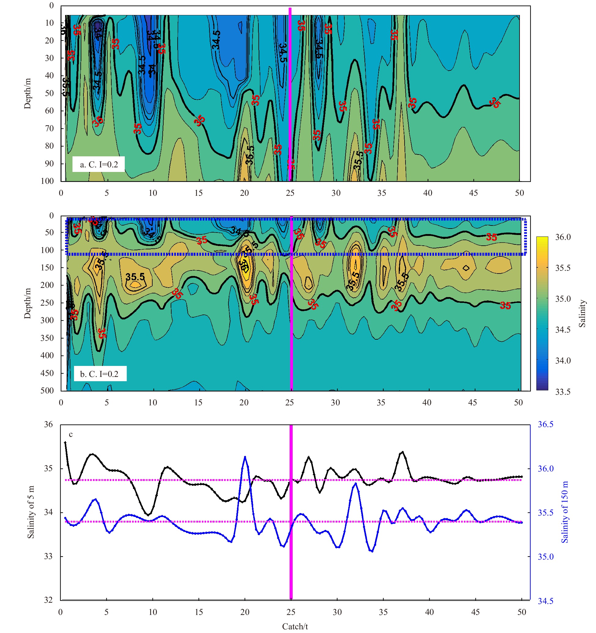
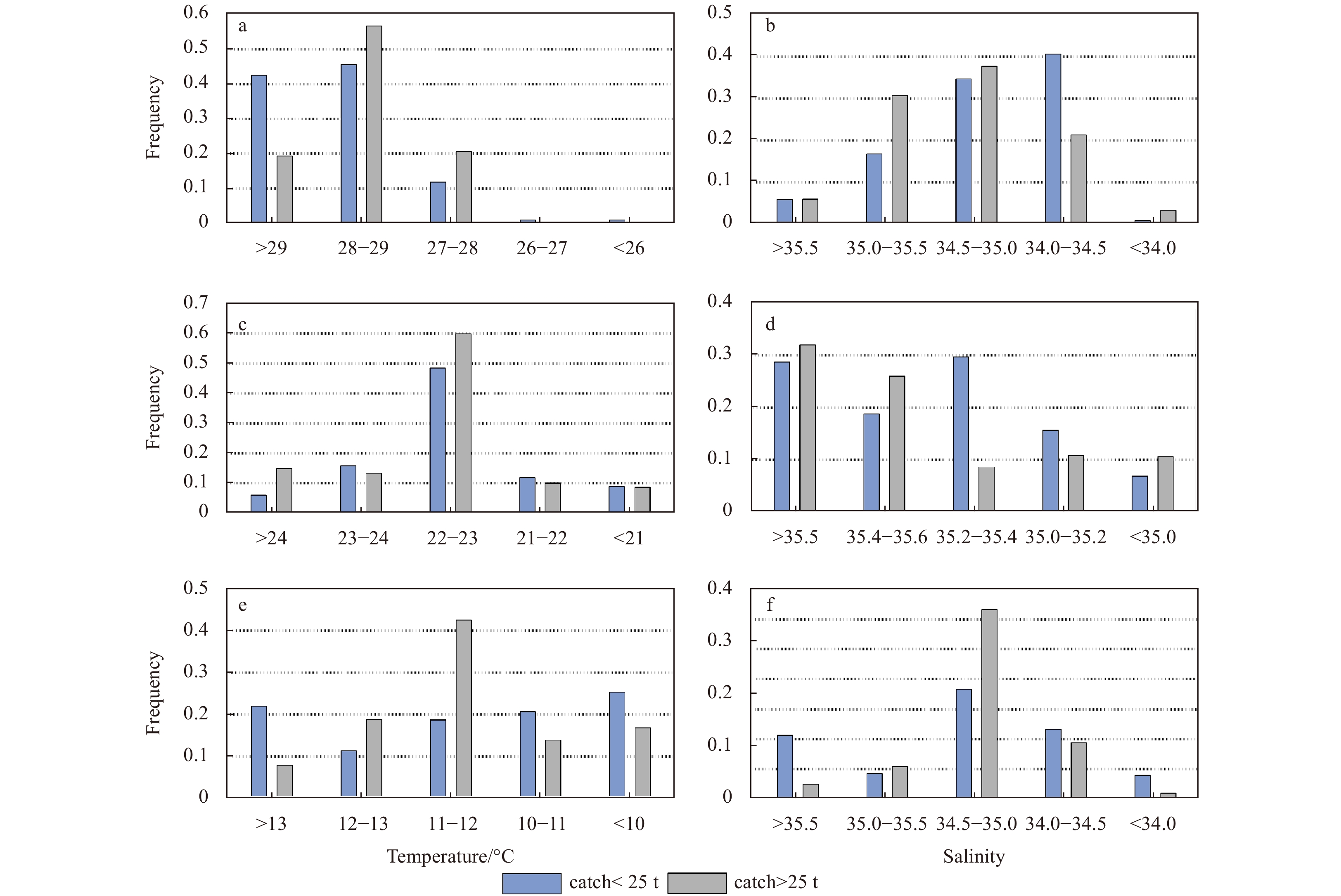
The current lack of high-precision information on subsurface seawater is a constraint in fishery research. Based on Argo temperature and salinity profiles, this study applied the gradient-dependent optimal interpolation to reconstruct daily subsurface oceanic environmental information according to fishery dates and locations. The relationship between subsurface information and matching yellowfin tuna (YFT) in the western and central Pacific Ocean (WCPO) was examined using catch data from January 1, 2008 to August 31, 2017. The seawater temperature and salinity results showed differences of less than ±0.5°C and ±0.01 compared with the truth observations respectively. Statistical analysis revealed that the most suitable temperature for YFT fishery was 28–29°C at the near-surface. The most suitable salinity range for YFT fishery was 34.5–36.0 at depths shallower than 300 m. The suitable upper and lower bounds on the depths of the thermocline were 90–100 m and 300–350 m, respectively. The thermocline characteristics were prominent, with a mean temperature gradient exceeding 0.08°C/m. These results indicate that the profiles constructed by gradient-dependent optimal interpolation were more accurate than those of the nearest profiles adopted.
The current lack of high-precision information on subsurface seawater is a constraint in fishery research. Based on Argo temperature and salinity profiles, this study applied the gradient-dependent optimal interpolation to reconstruct daily subsurface oceanic environmental information according to fishery dates and locations. The relationship between subsurface information and matching yellowfin tuna (YFT) in the western and central Pacific Ocean (WCPO) was examined using catch data from January 1, 2008 to August 31, 2017. The seawater temperature and salinity results showed differences of less than ±0.5°C and ±0.01 compared with the truth observations respectively. Statistical analysis revealed that the most suitable temperature for YFT fishery was 28–29°C at the near-surface. The most suitable salinity range for YFT fishery was 34.5–36.0 at depths shallower than 300 m. The suitable upper and lower bounds on the depths of the thermocline were 90–100 m and 300–350 m, respectively. The thermocline characteristics were prominent, with a mean temperature gradient exceeding 0.08°C/m. These results indicate that the profiles constructed by gradient-dependent optimal interpolation were more accurate than those of the nearest profiles adopted.


2022, 41(2): 127-138.
doi: 10.1007/s13131-021-1849-4
Abstract:
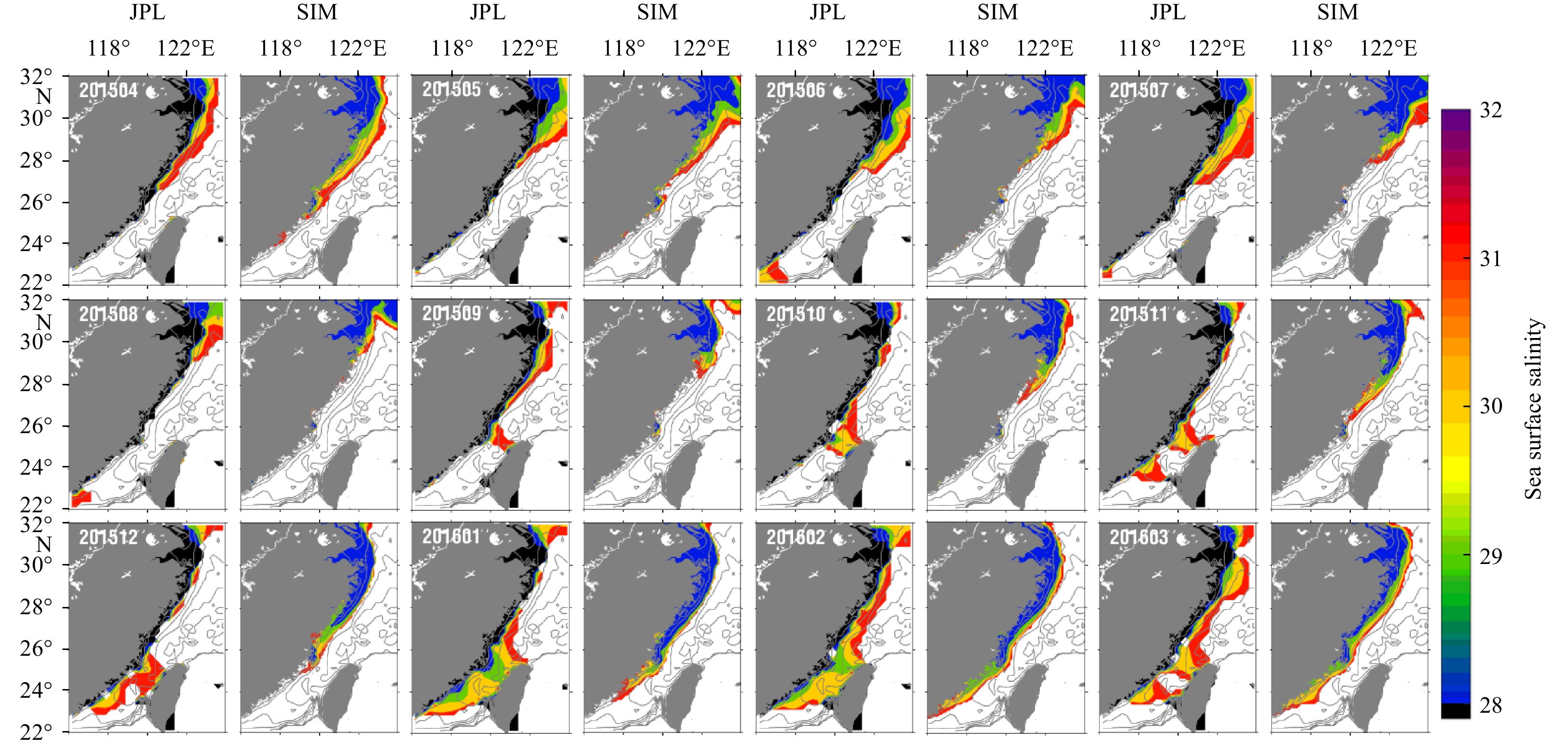
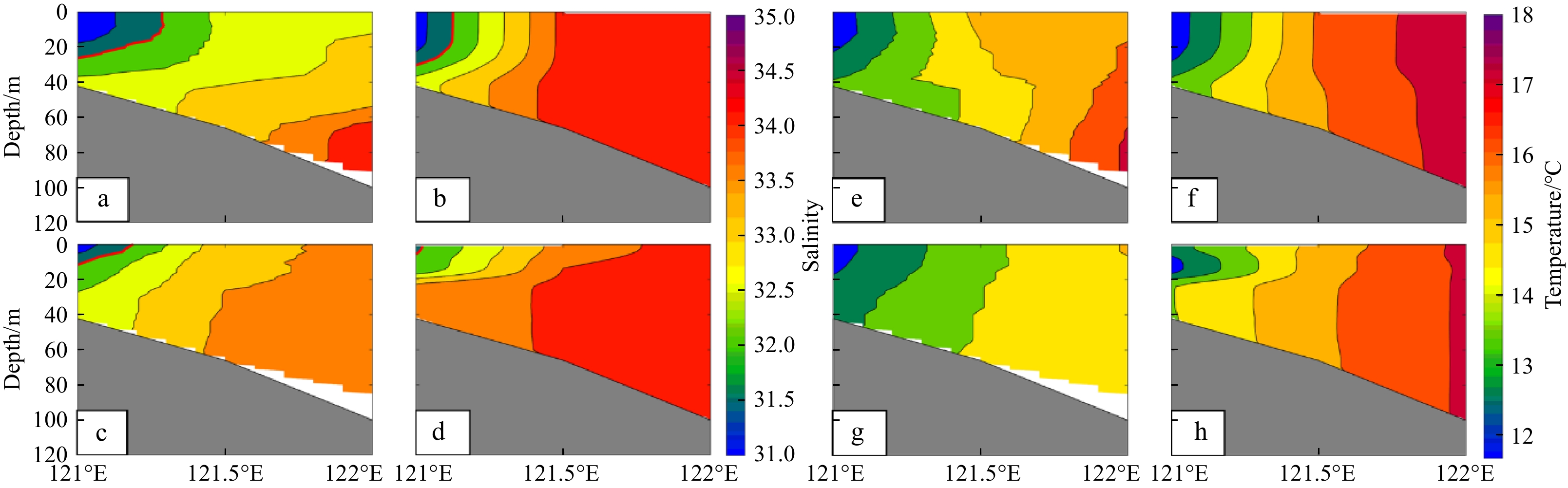
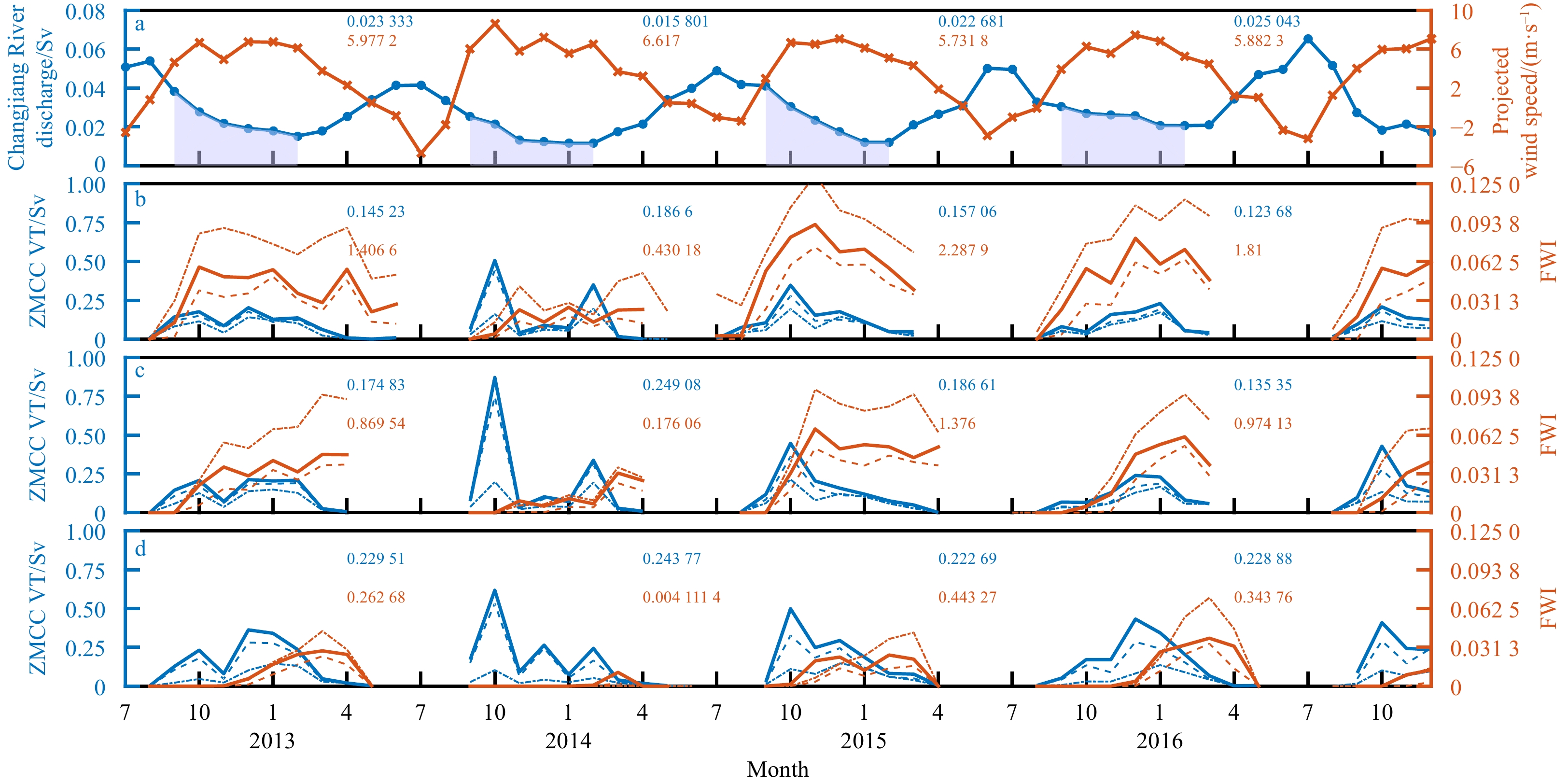
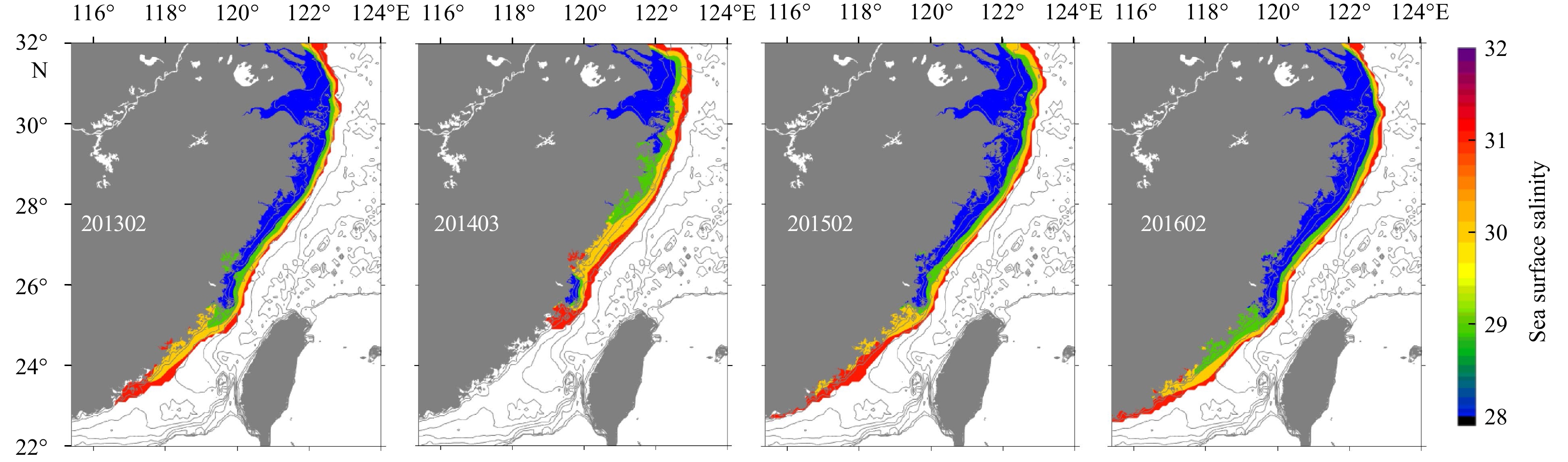
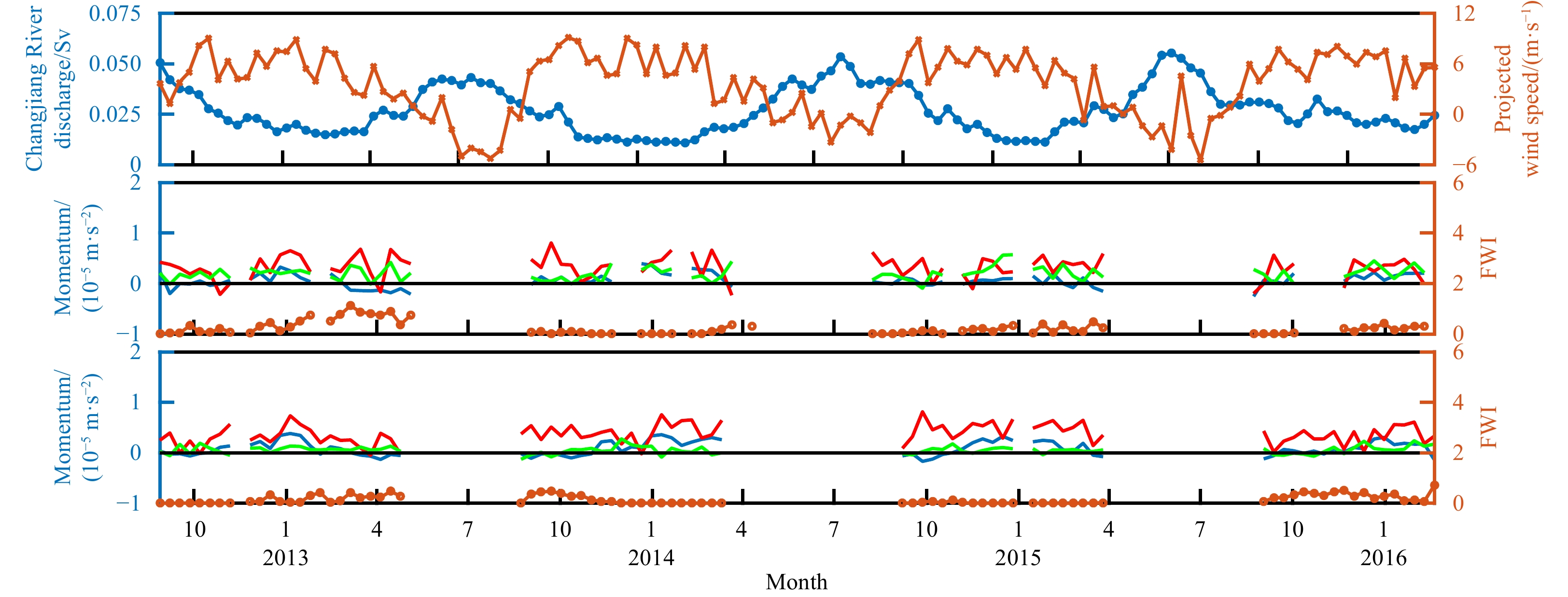
During the northeast monsoon season, Zhe-Min Coastal Current (ZMCC) travels along the Chinese mainland coast and carries fresh, cold, and eutrophic water. ZMCC is significantly important for the hydrodynamic processes and marine ecosystems along its path. Thus, this bottom-trapped plume deserves to be further discussed in terms of the major driving factor, for which different opinions exist. For this purpose, in this study, a high resolution Semi-implicit Cross-scale Hydroscience Integrated System Model (SCHISM) is established and validated. High correlation coefficients exist between along-shelf wind speeds and seasonal variations of both ZMCC volume transport and the freshwater signal. These coefficients imply that the wind is important in regulating ZMCC. However, for similar annual mean ZMCC volume transports, the extreme south boundaries of Zhe-Min Coastal Water (ZMCW) are different among different years. This difference is attracting attention and is explored in this study. According to the low wind/discharge experiment, it was found that although the volume transport of ZMCC is more sensitive to the variation of local wind speeds, the carried freshwater is limited by the Changjiang River discharge, which ultimately determines the south boundary of ZMCW. The momentum analysis at transects I and II shows that, for driving ZMCC, the along-shore wind forcing is as important as the buoyancy forcing. Note that this conclusion is supported by a zero-discharge experiment. It was also found that the buoyancy forcing varies with respect to time and space, which is due to variations of the discharge of Changjiang River. In addition, a particle tracking experiment shows that the substance carried by the Changjiang River diluted water would distribute along the Zhe-Min coastal region during the northeast monsoon season and it may escape due to the wind relaxation.
During the northeast monsoon season, Zhe-Min Coastal Current (ZMCC) travels along the Chinese mainland coast and carries fresh, cold, and eutrophic water. ZMCC is significantly important for the hydrodynamic processes and marine ecosystems along its path. Thus, this bottom-trapped plume deserves to be further discussed in terms of the major driving factor, for which different opinions exist. For this purpose, in this study, a high resolution Semi-implicit Cross-scale Hydroscience Integrated System Model (SCHISM) is established and validated. High correlation coefficients exist between along-shelf wind speeds and seasonal variations of both ZMCC volume transport and the freshwater signal. These coefficients imply that the wind is important in regulating ZMCC. However, for similar annual mean ZMCC volume transports, the extreme south boundaries of Zhe-Min Coastal Water (ZMCW) are different among different years. This difference is attracting attention and is explored in this study. According to the low wind/discharge experiment, it was found that although the volume transport of ZMCC is more sensitive to the variation of local wind speeds, the carried freshwater is limited by the Changjiang River discharge, which ultimately determines the south boundary of ZMCW. The momentum analysis at transects I and II shows that, for driving ZMCC, the along-shore wind forcing is as important as the buoyancy forcing. Note that this conclusion is supported by a zero-discharge experiment. It was also found that the buoyancy forcing varies with respect to time and space, which is due to variations of the discharge of Changjiang River. In addition, a particle tracking experiment shows that the substance carried by the Changjiang River diluted water would distribute along the Zhe-Min coastal region during the northeast monsoon season and it may escape due to the wind relaxation.


2022, 41(2): 139-146.
doi: 10.1007/s13131-021-1837-8
Abstract:
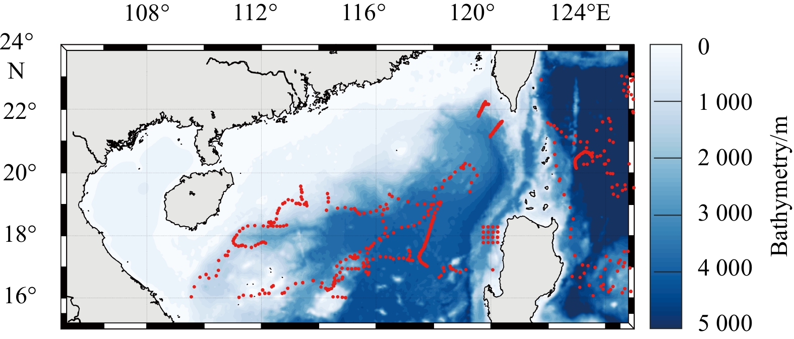
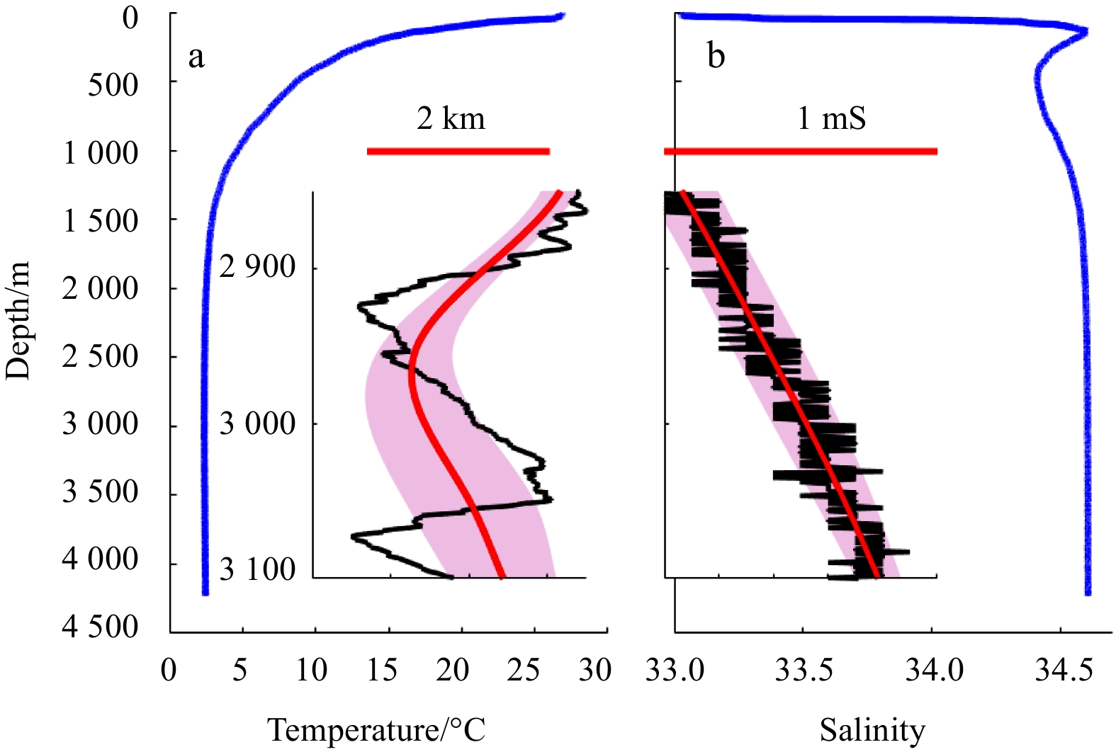
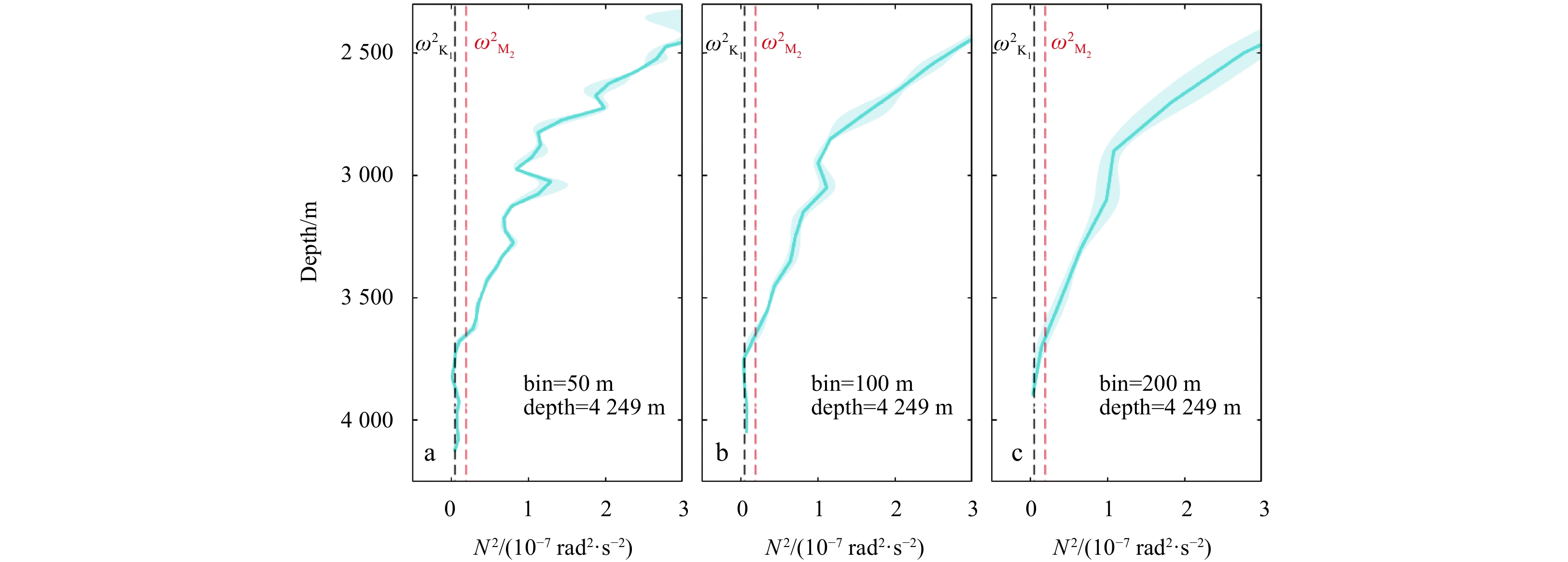
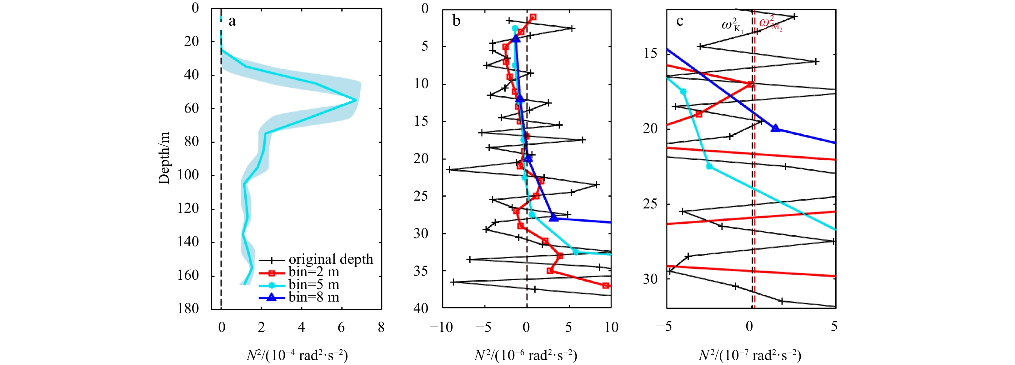
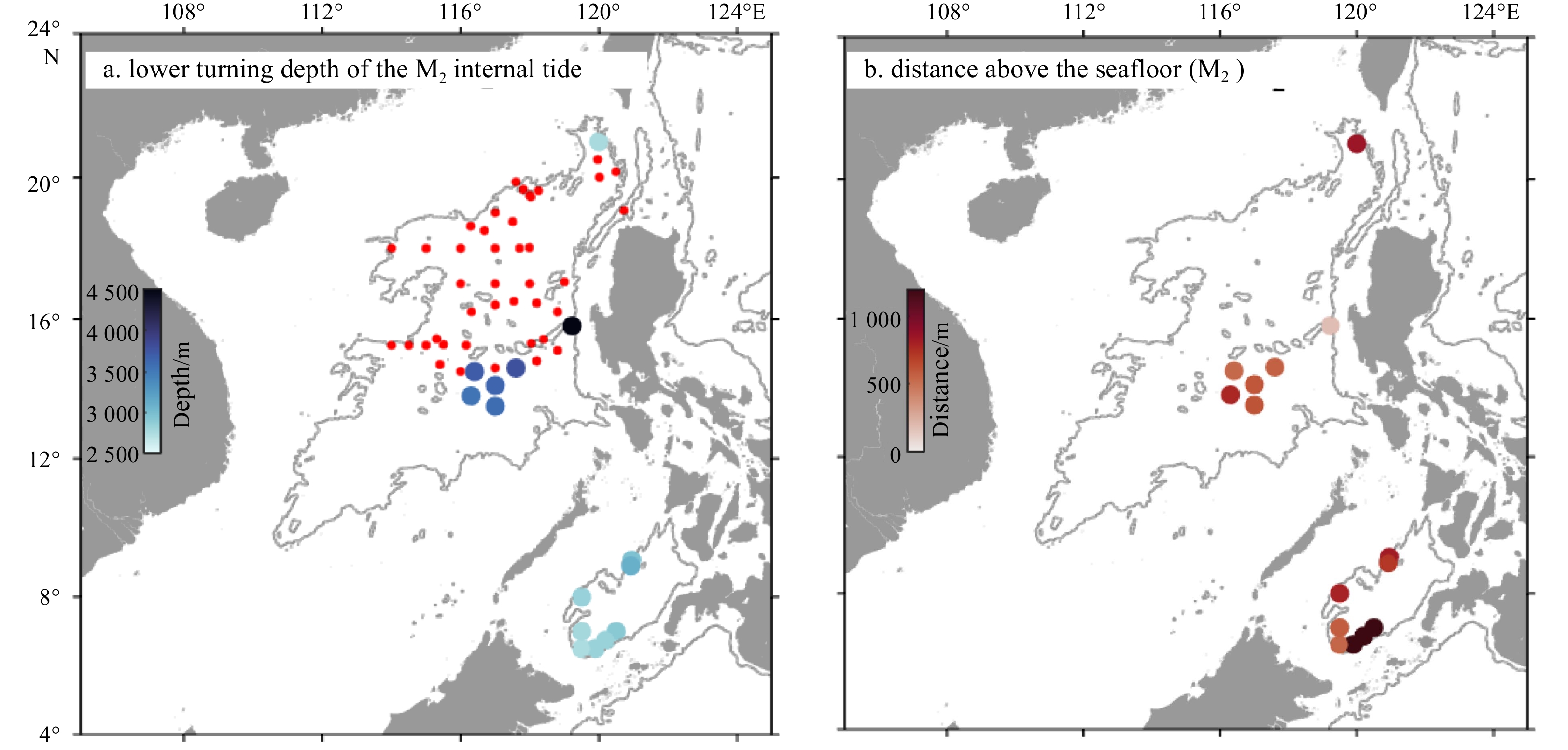
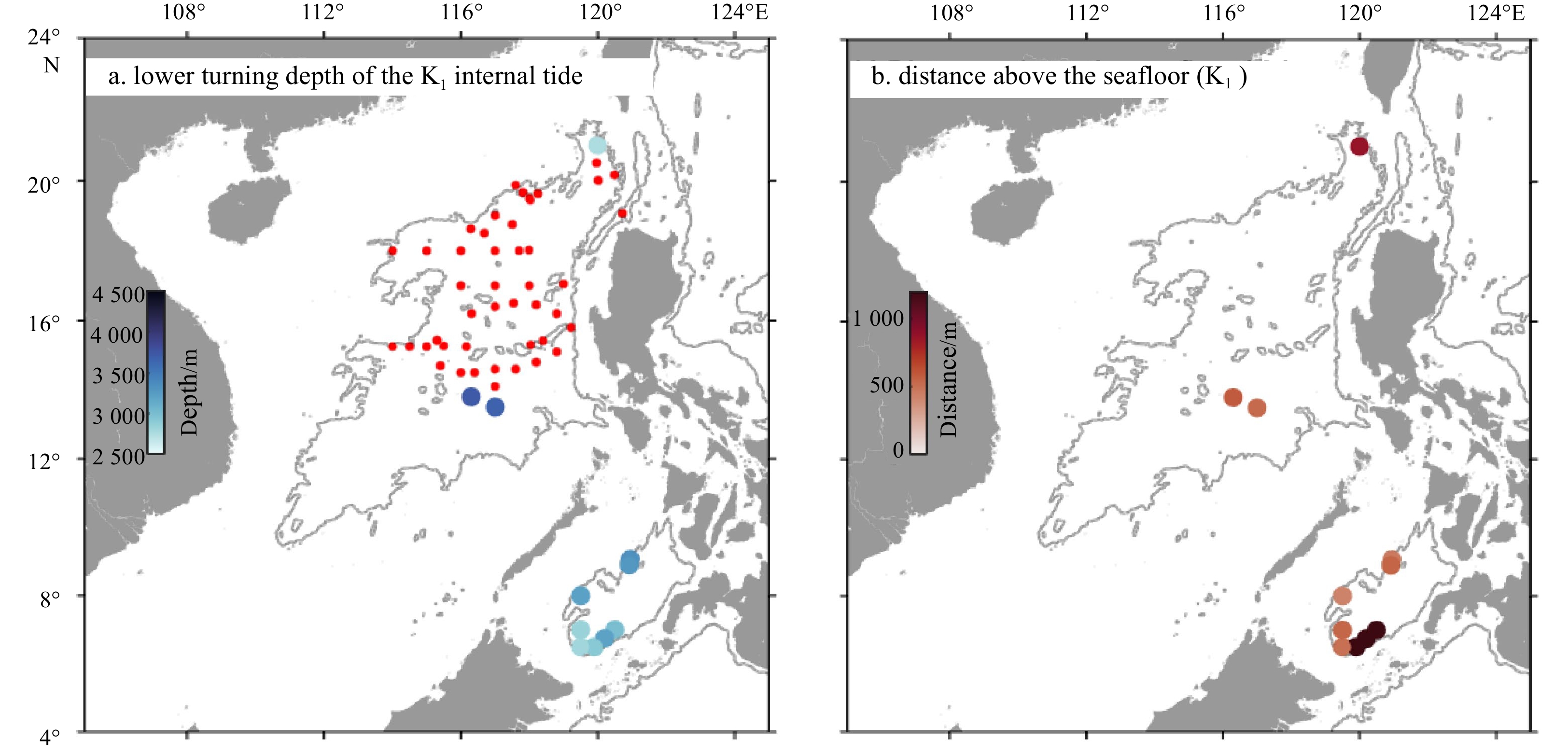
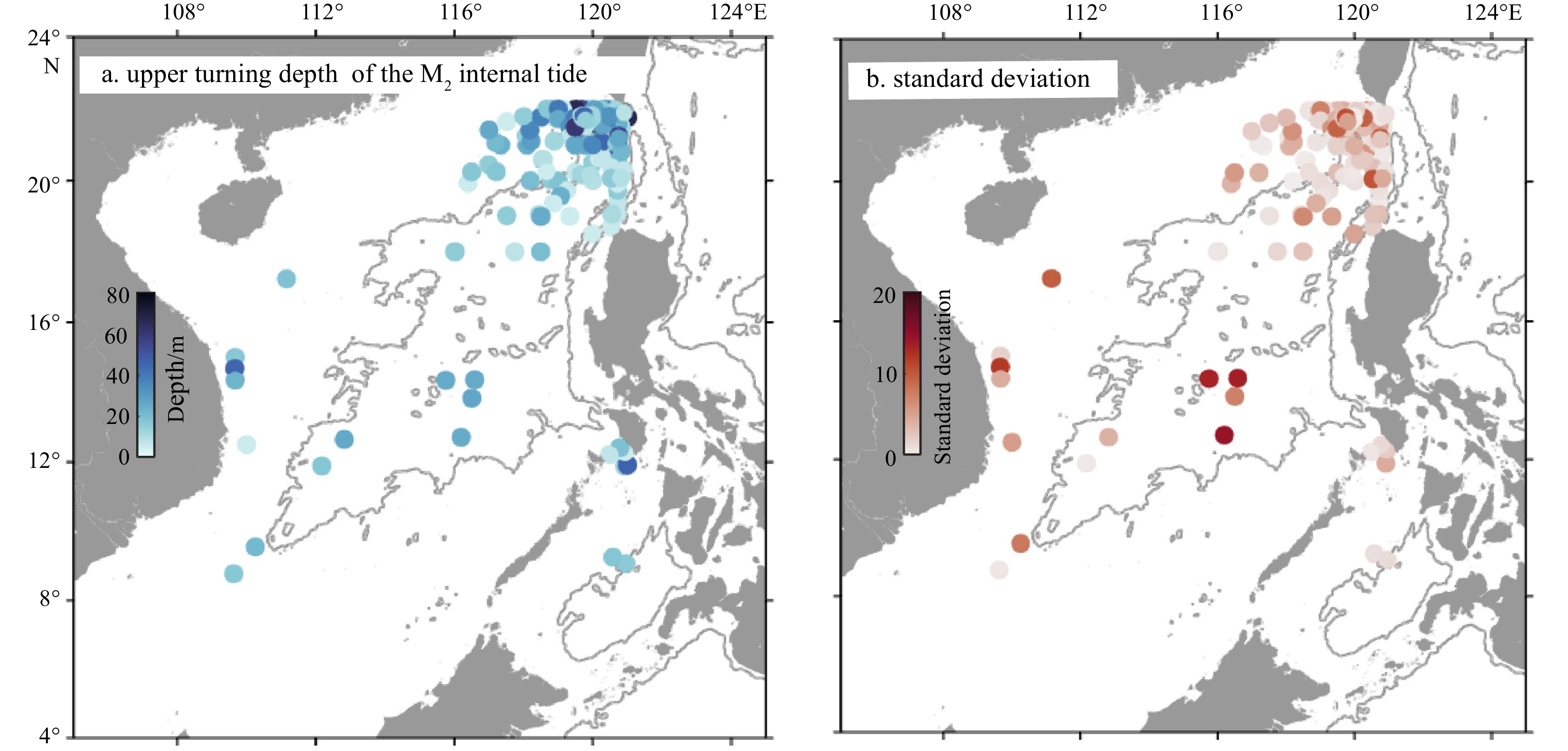
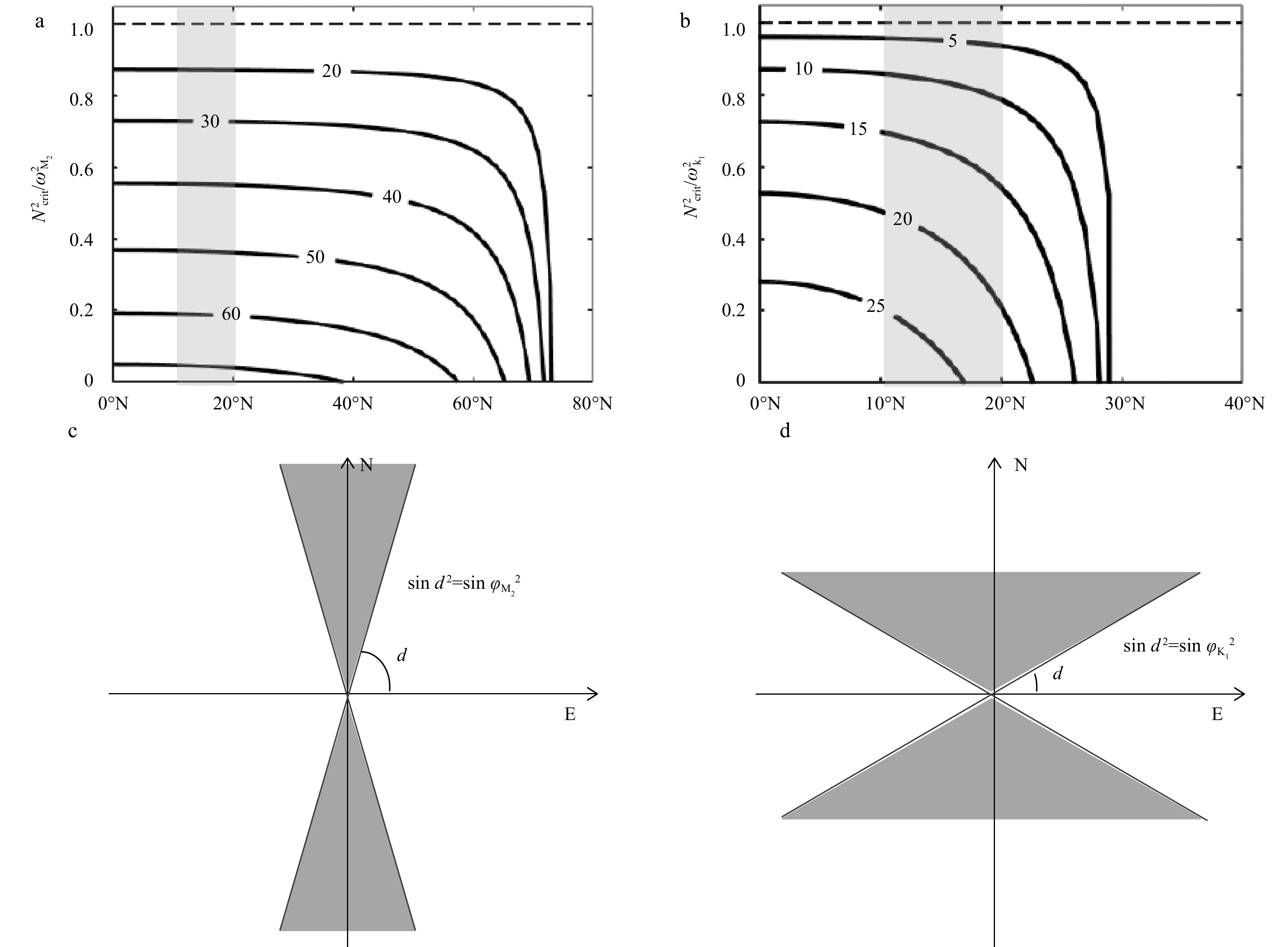
Theoretically, propagating internal tides in the ocean may reflect at turning depths, where buoyancy frequencies equal tidal frequencies, before colliding with the air-sea interface or rugged bottom topography. Globally, the internal tide lower turning depths (ITLTDs) in the open ocean have been mapped; however, knowledge of the presence of ITLTDs in the South China Sea (SCS) is lacking. In this study, 2 125 high-quality temperature-salinity profiles (including 58 deep-sea hydrographic measurements with observational depths exceeding 3 000 m) are collected and analyzed to investigate the existence of ITLTDs in the SCS. Furthermore, the concept of the upper turning depth is first introduced in the context of internal tides, and internal tide upper turning depths (ITUTDs) are also investigated. ITLTDs are found to exist at several abyssal stations; these stations are distributed mostly in the southern part of the SCS basin, possibly due to the greater water depths there. Fewer locations show the presence of ITLTDs for K1 versus M2 tidal frequencies because of the lower tidal frequency. The distance between ITLTDs and the seafloor ranged from 270 m to more than 1 200 m, implying the possible existence of multiple internal wave evanescent regions in the abyssal bottom. ITUTDs of tens of meters are ubiquitous in the SCS; stations with the presence of ITUTDs are located mainly in the northeastern SCS due to the intensive observations there. However, the calculated ITUTDs have large uncertainties; they are sensitive to the selected bin values. The horizontal propagation directions of internal tides in the SCS change dramatically, and as a result, the estimated turning depths under the full Coriolis force definition are different compared to that under the traditional approximation.
Theoretically, propagating internal tides in the ocean may reflect at turning depths, where buoyancy frequencies equal tidal frequencies, before colliding with the air-sea interface or rugged bottom topography. Globally, the internal tide lower turning depths (ITLTDs) in the open ocean have been mapped; however, knowledge of the presence of ITLTDs in the South China Sea (SCS) is lacking. In this study, 2 125 high-quality temperature-salinity profiles (including 58 deep-sea hydrographic measurements with observational depths exceeding 3 000 m) are collected and analyzed to investigate the existence of ITLTDs in the SCS. Furthermore, the concept of the upper turning depth is first introduced in the context of internal tides, and internal tide upper turning depths (ITUTDs) are also investigated. ITLTDs are found to exist at several abyssal stations; these stations are distributed mostly in the southern part of the SCS basin, possibly due to the greater water depths there. Fewer locations show the presence of ITLTDs for K1 versus M2 tidal frequencies because of the lower tidal frequency. The distance between ITLTDs and the seafloor ranged from 270 m to more than 1 200 m, implying the possible existence of multiple internal wave evanescent regions in the abyssal bottom. ITUTDs of tens of meters are ubiquitous in the SCS; stations with the presence of ITUTDs are located mainly in the northeastern SCS due to the intensive observations there. However, the calculated ITUTDs have large uncertainties; they are sensitive to the selected bin values. The horizontal propagation directions of internal tides in the SCS change dramatically, and as a result, the estimated turning depths under the full Coriolis force definition are different compared to that under the traditional approximation.

2022, 41(2): 147-155.
doi: 10.1007/s13131-021-1769-3
Abstract:
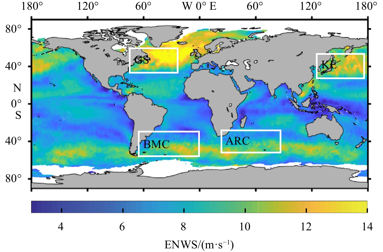
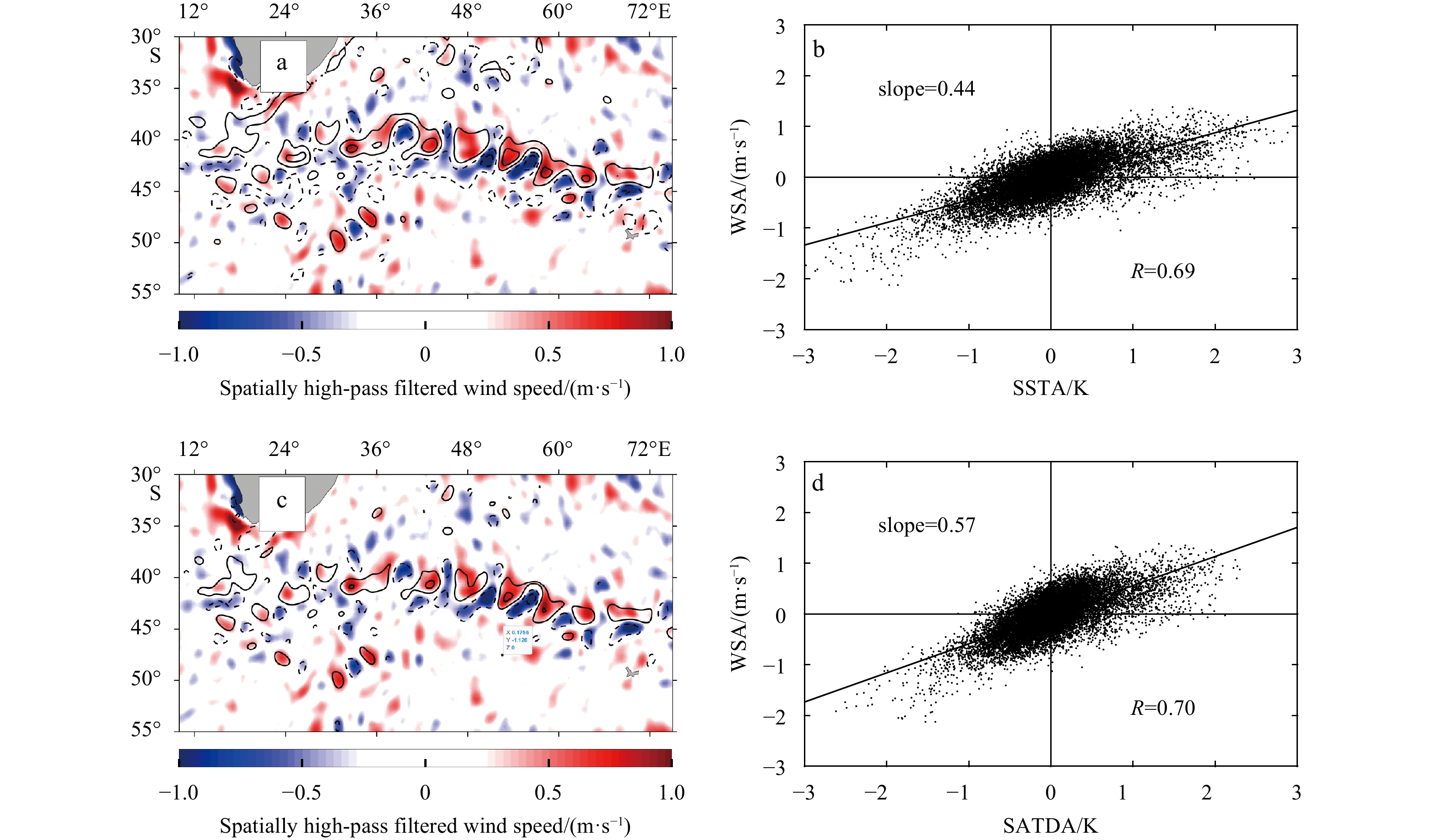
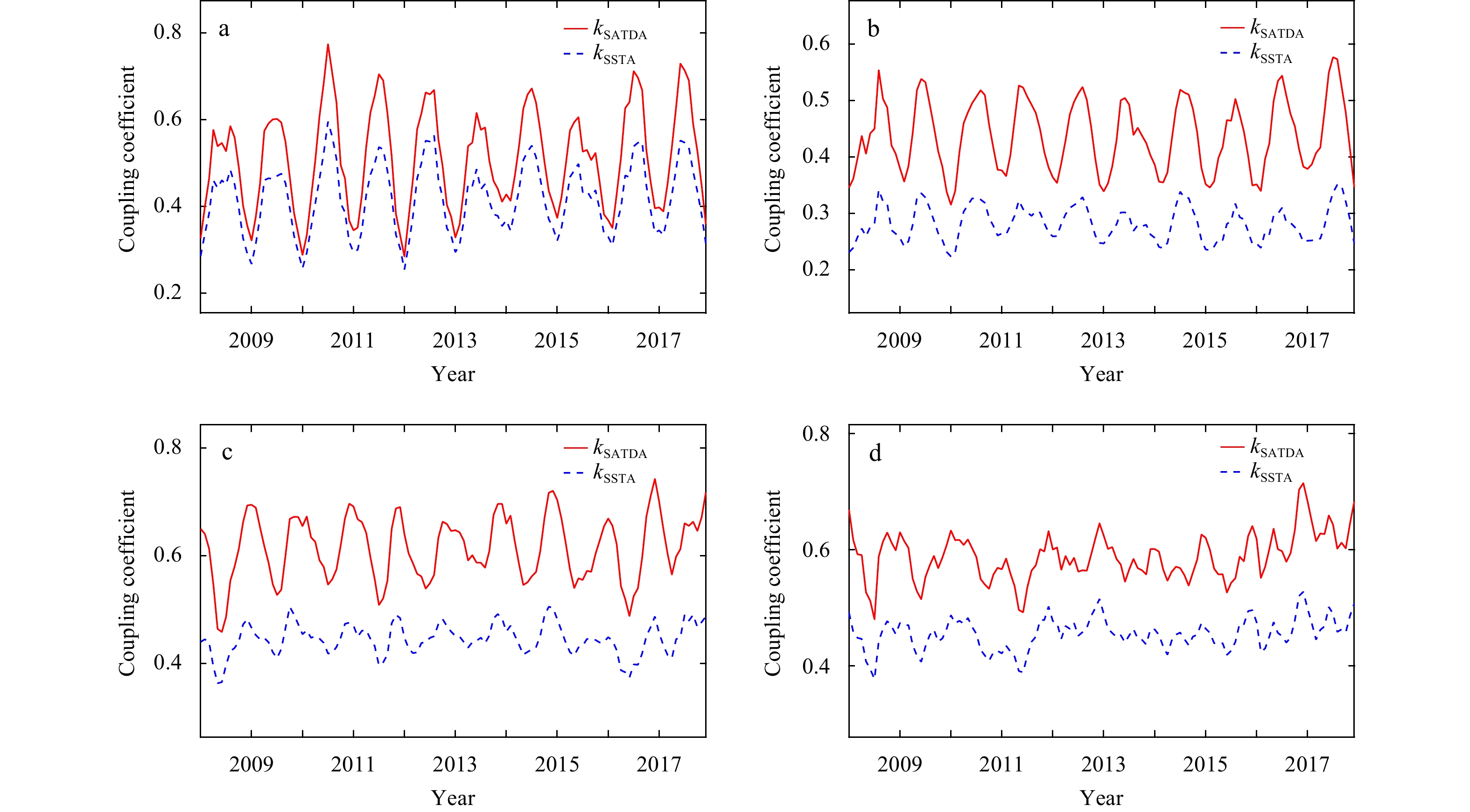
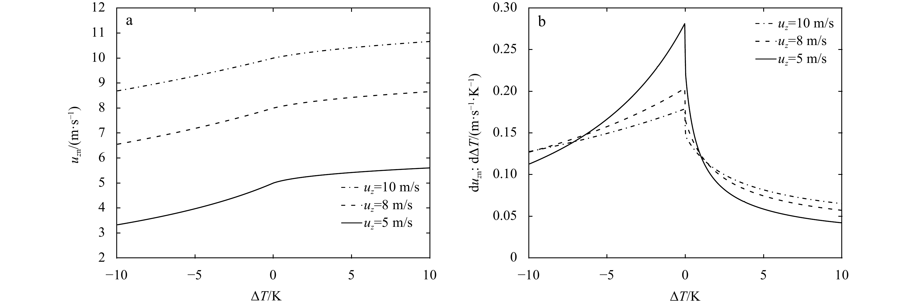
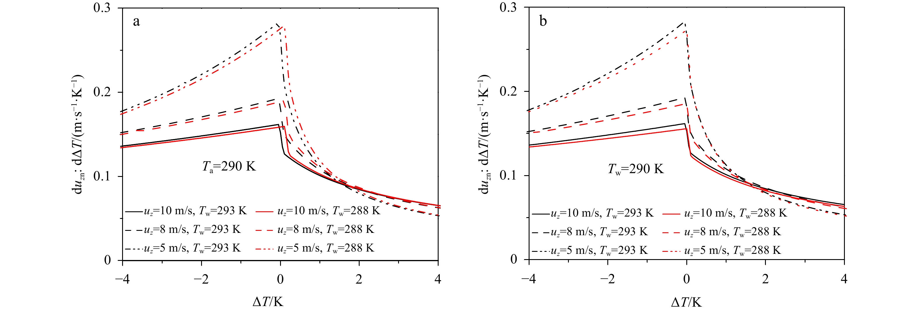
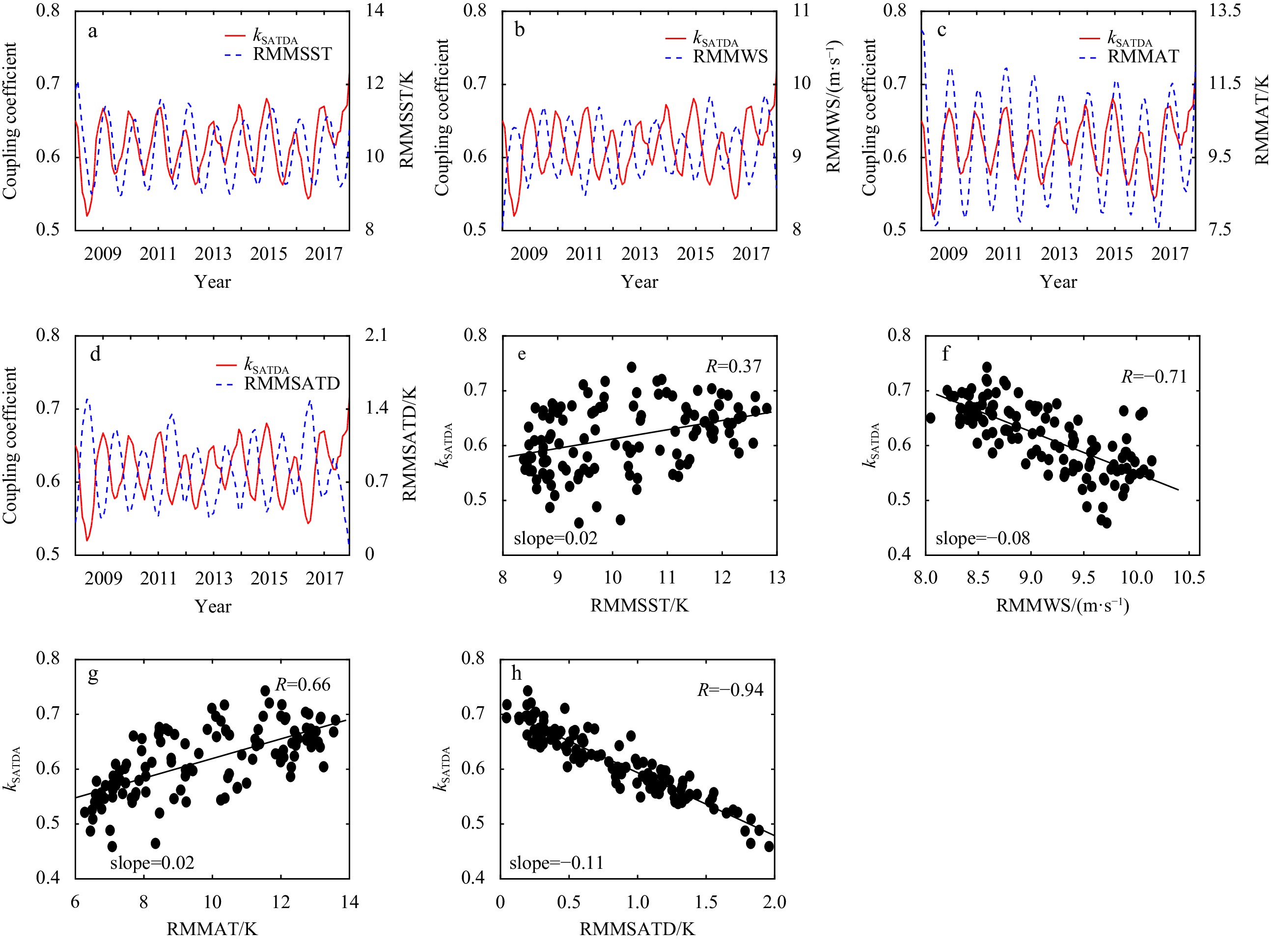
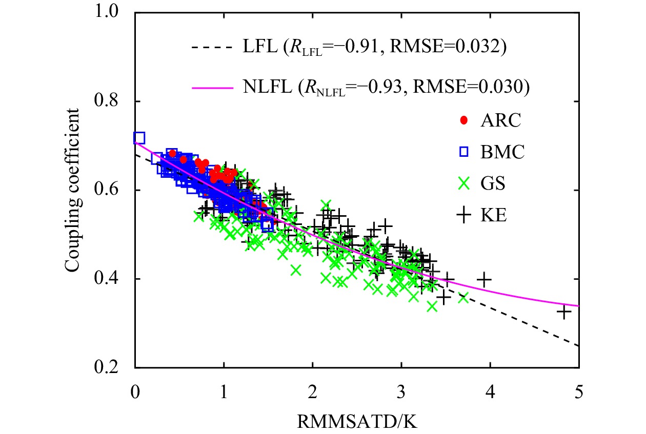
The response relationship between equivalent neutral wind speed anomaly (ENWSA) and sea-air temperature difference anomaly (SATDA) has been analyzed over four typical sea regions, i.e., the Kuroshio Extension, the Gulf Stream, the Brazil-Malvinas Confluence and the Agulhas Return Current. The results show that ENWSA is more sensitive to SATDA than sea surface temperature anomaly (SSTA), which implies that SATDA seems to be a more suitable parameter than SSTA to analyze the mesoscale air-sea interactions. Here, the slope of the linear relation between ENWSA and SATDA is defined as the air-sea coupling coefficient. It is found that the values of the coupling coefficient over the four typical sea areas have obvious seasonal variations and geographical differences. In order to reveal the reason of the seasonal variation and geographical difference of the coupling coefficient, the influences of some environmental background factors, such as the spatially averaged sea surface temperature (SST), the spatially averaged air temperature, the spatially averaged sea-air temperature difference and the spatially averaged equivalent neutral wind speed, on the coupling coefficient are discussed in detail. The results reveal that the background sea-air temperature difference is an important environmental factor which directly affects the magnitude of the coupling coefficients, meanwhile, the seasonal and geographical variations of the coupling coefficient.
The response relationship between equivalent neutral wind speed anomaly (ENWSA) and sea-air temperature difference anomaly (SATDA) has been analyzed over four typical sea regions, i.e., the Kuroshio Extension, the Gulf Stream, the Brazil-Malvinas Confluence and the Agulhas Return Current. The results show that ENWSA is more sensitive to SATDA than sea surface temperature anomaly (SSTA), which implies that SATDA seems to be a more suitable parameter than SSTA to analyze the mesoscale air-sea interactions. Here, the slope of the linear relation between ENWSA and SATDA is defined as the air-sea coupling coefficient. It is found that the values of the coupling coefficient over the four typical sea areas have obvious seasonal variations and geographical differences. In order to reveal the reason of the seasonal variation and geographical difference of the coupling coefficient, the influences of some environmental background factors, such as the spatially averaged sea surface temperature (SST), the spatially averaged air temperature, the spatially averaged sea-air temperature difference and the spatially averaged equivalent neutral wind speed, on the coupling coefficient are discussed in detail. The results reveal that the background sea-air temperature difference is an important environmental factor which directly affects the magnitude of the coupling coefficients, meanwhile, the seasonal and geographical variations of the coupling coefficient.


2022, 41(2): 156-165.
doi: 10.1007/s13131-021-1817-z
Abstract:
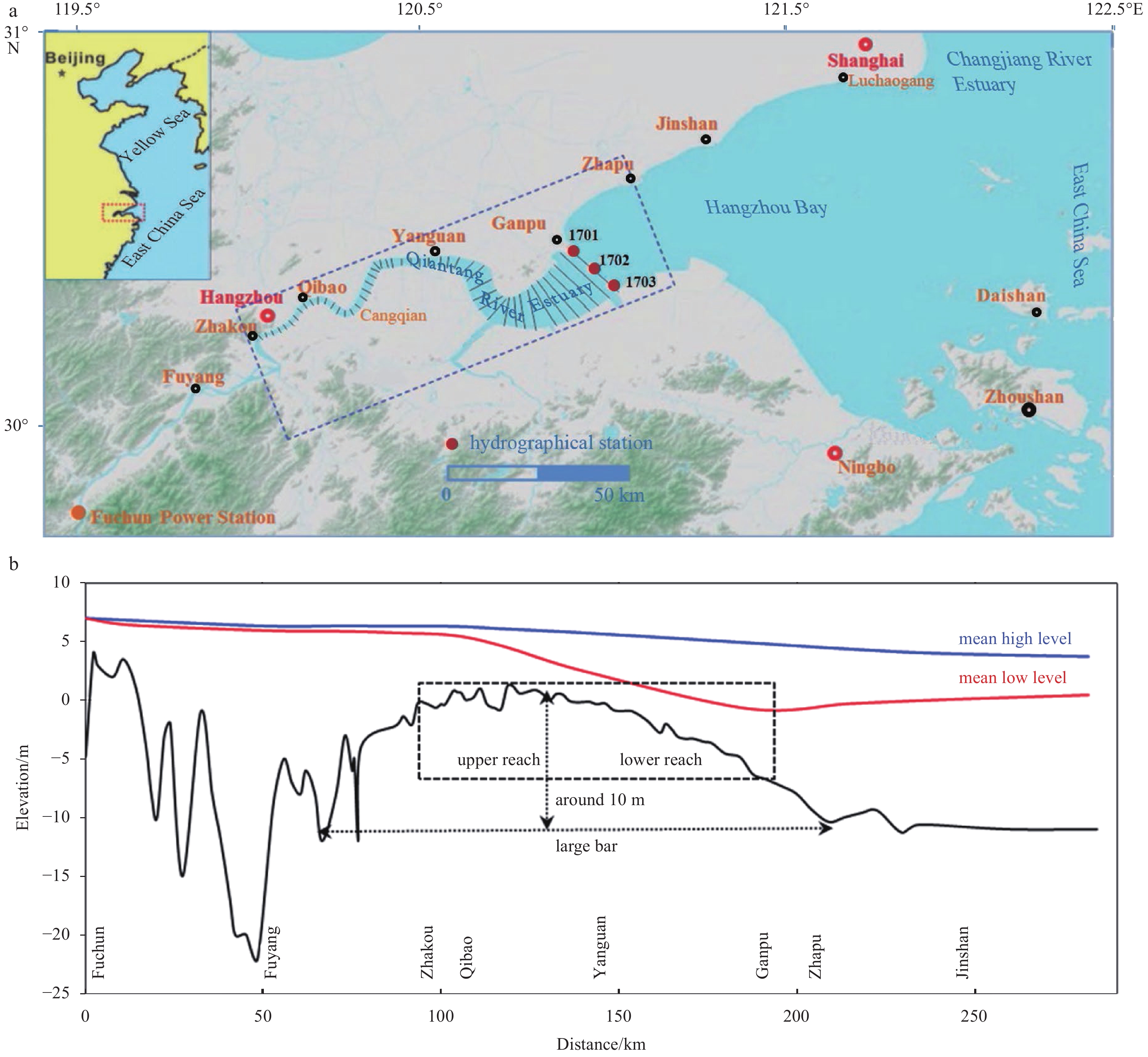
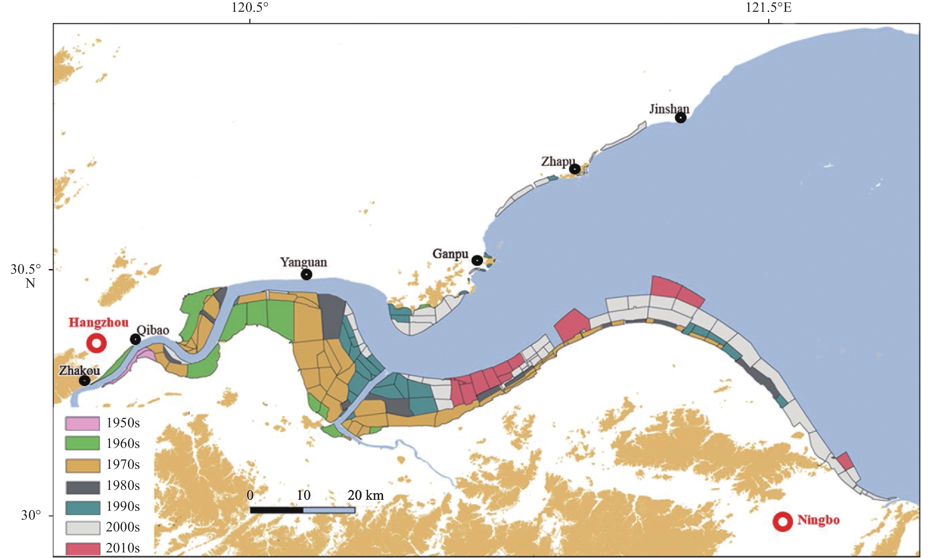
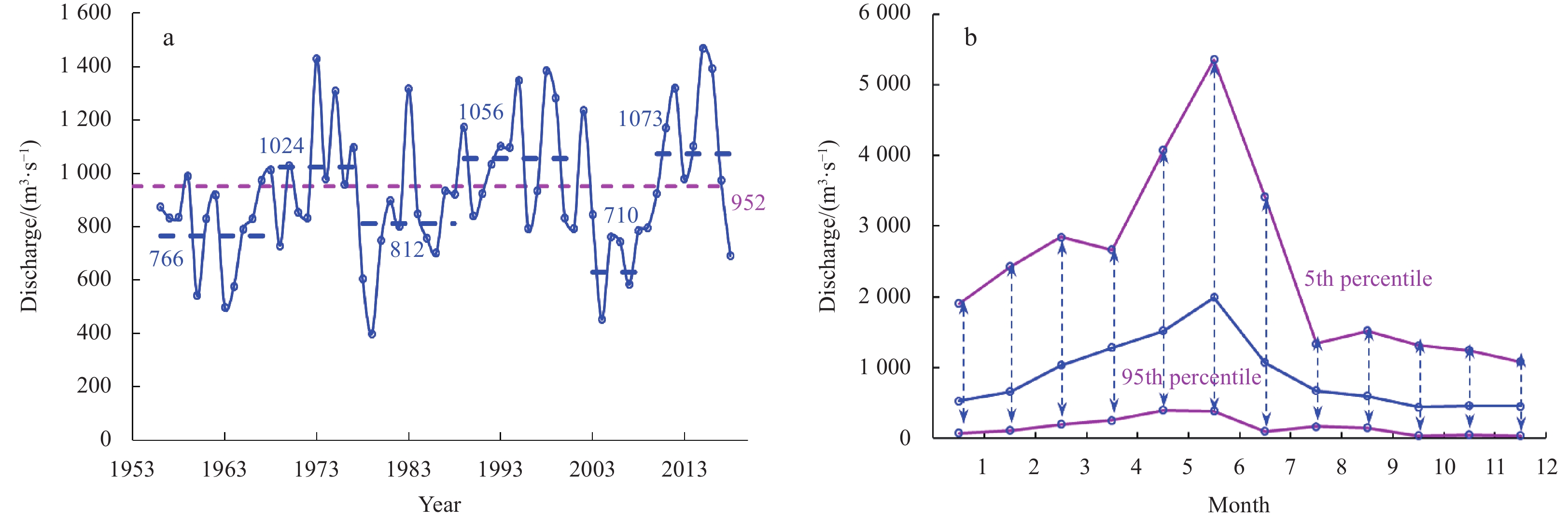
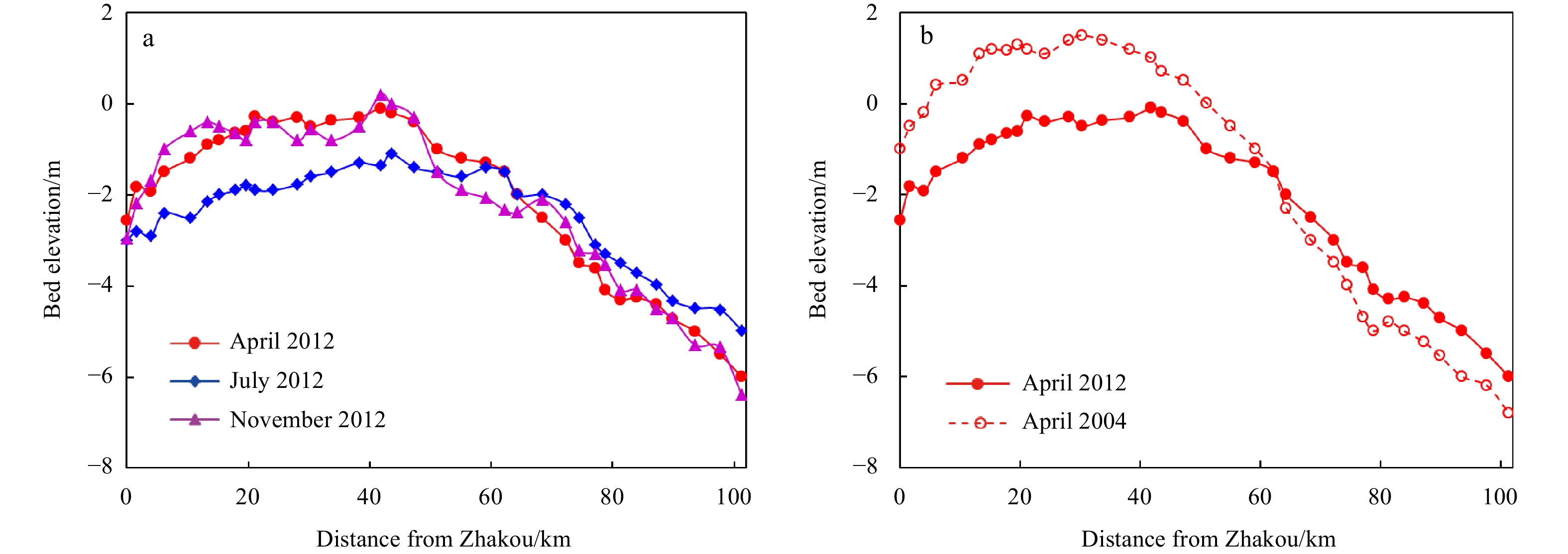
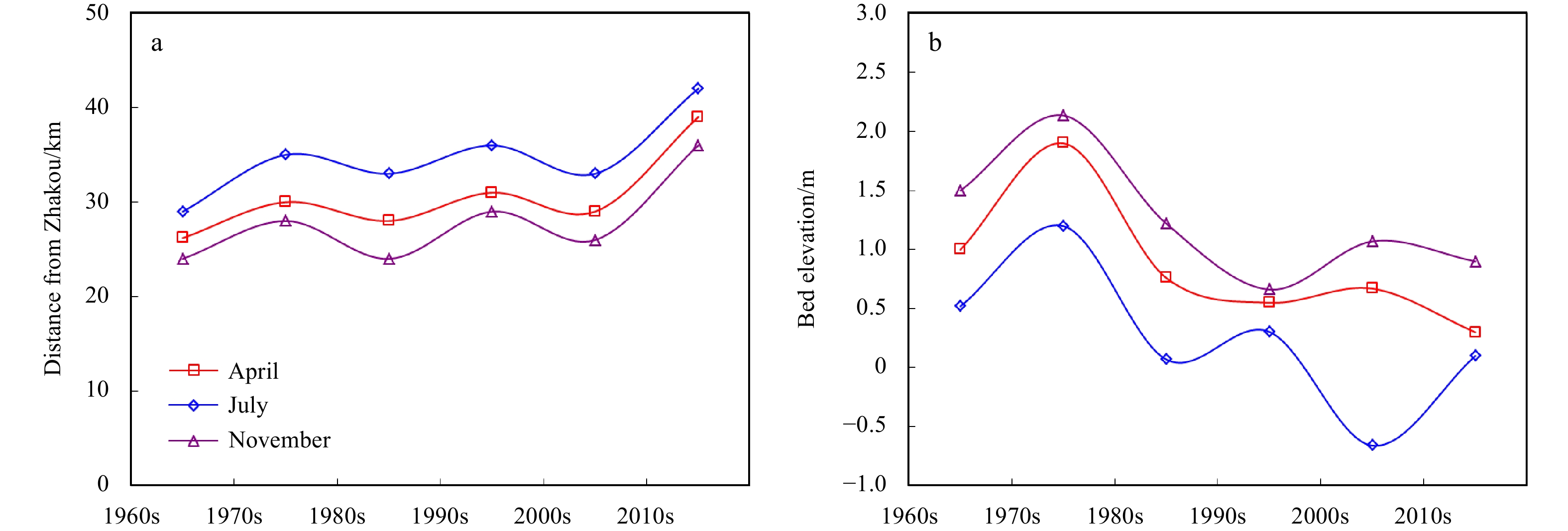
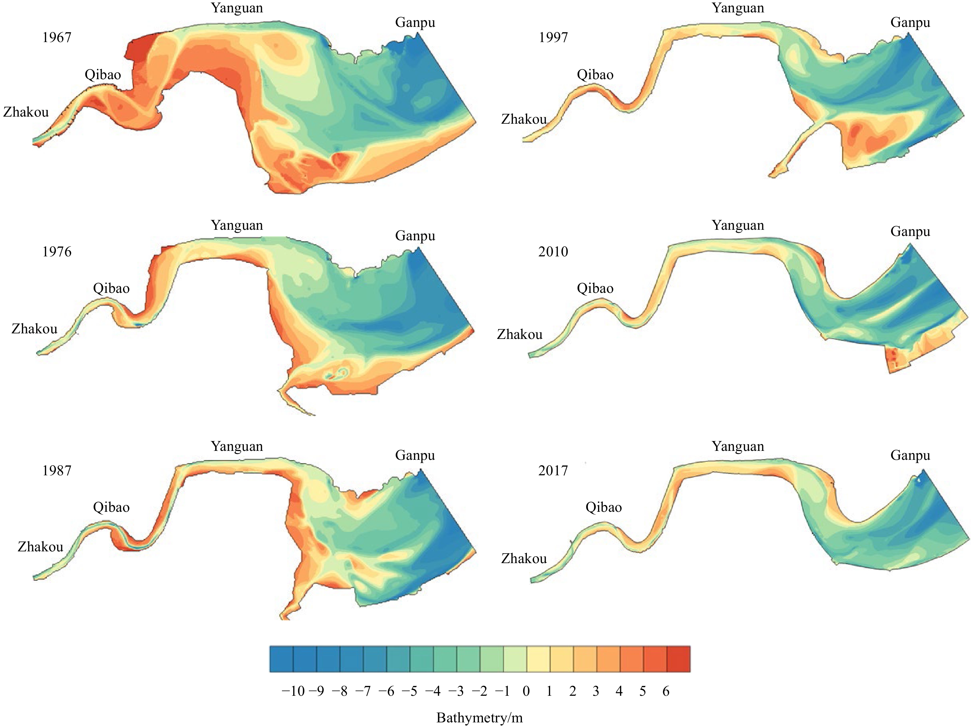
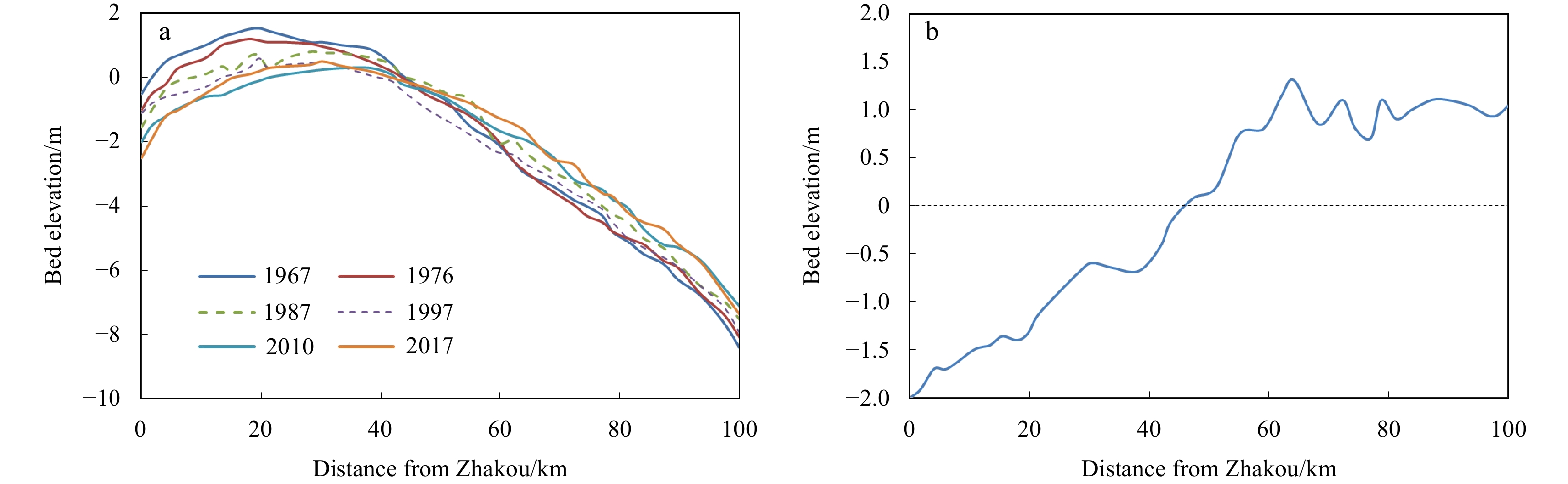
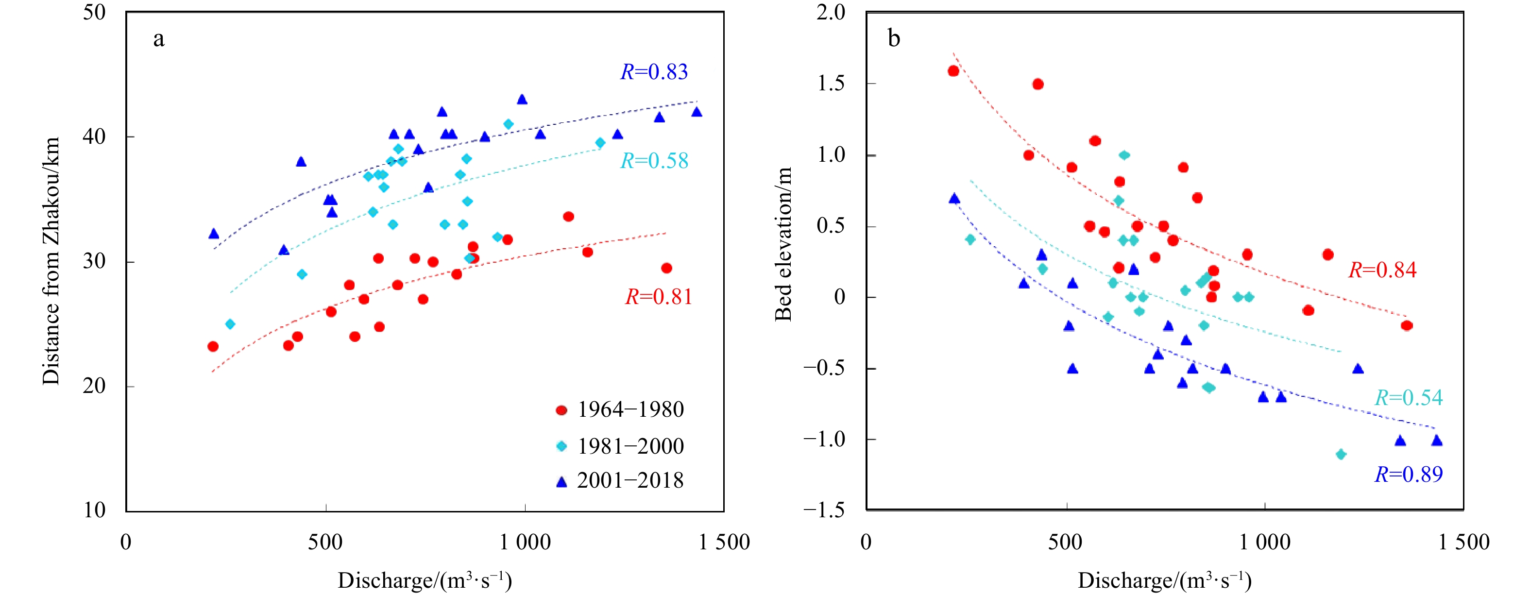
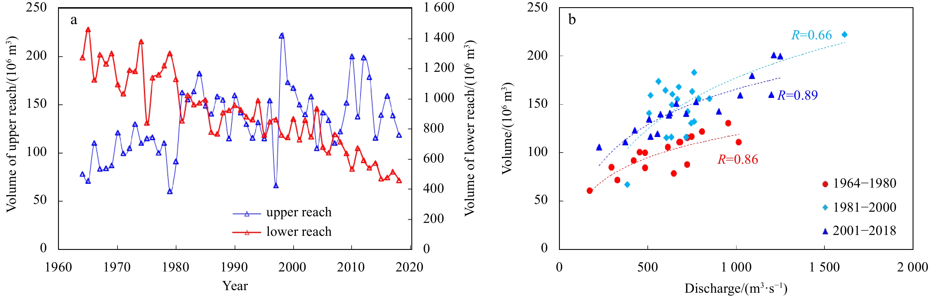
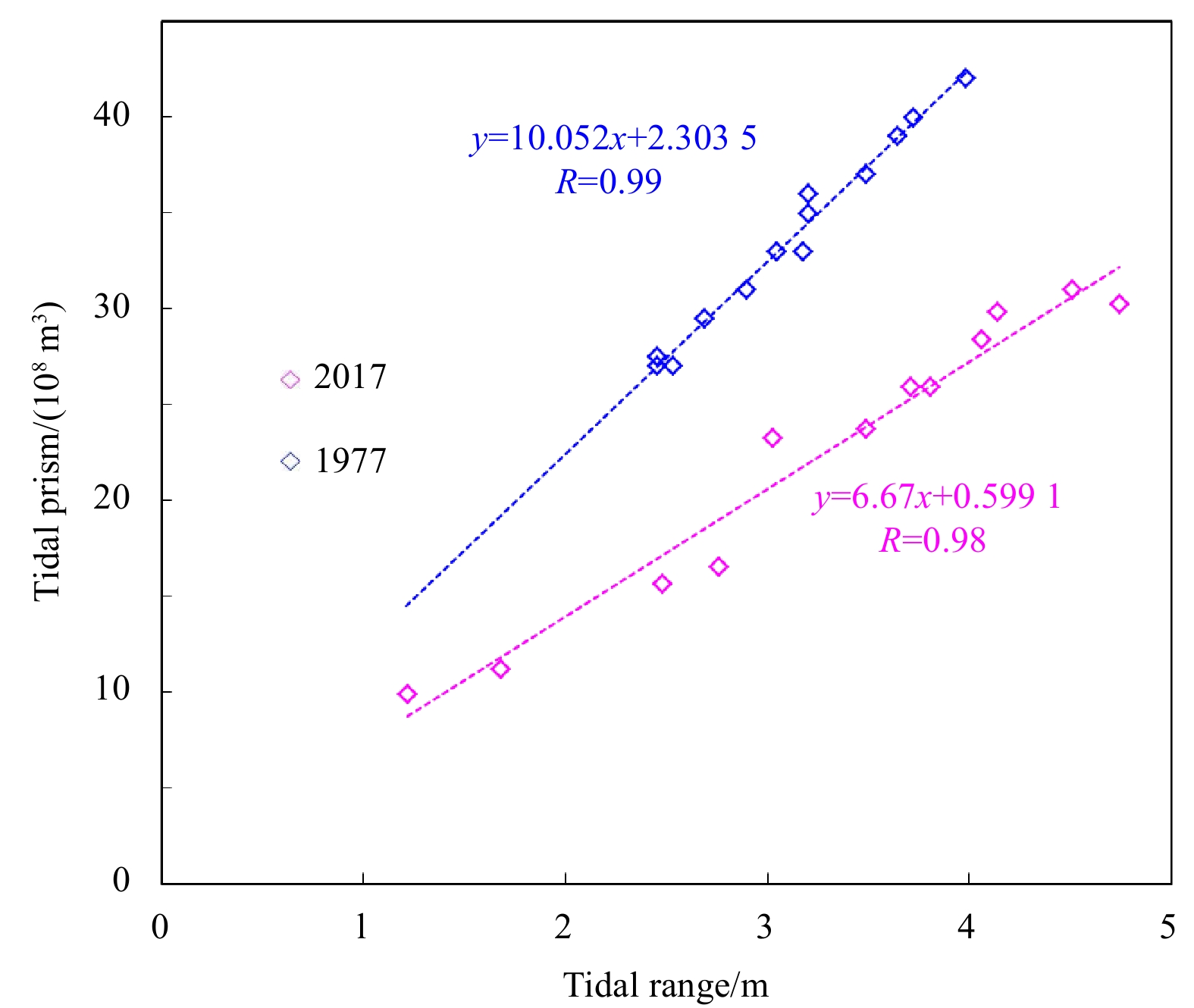
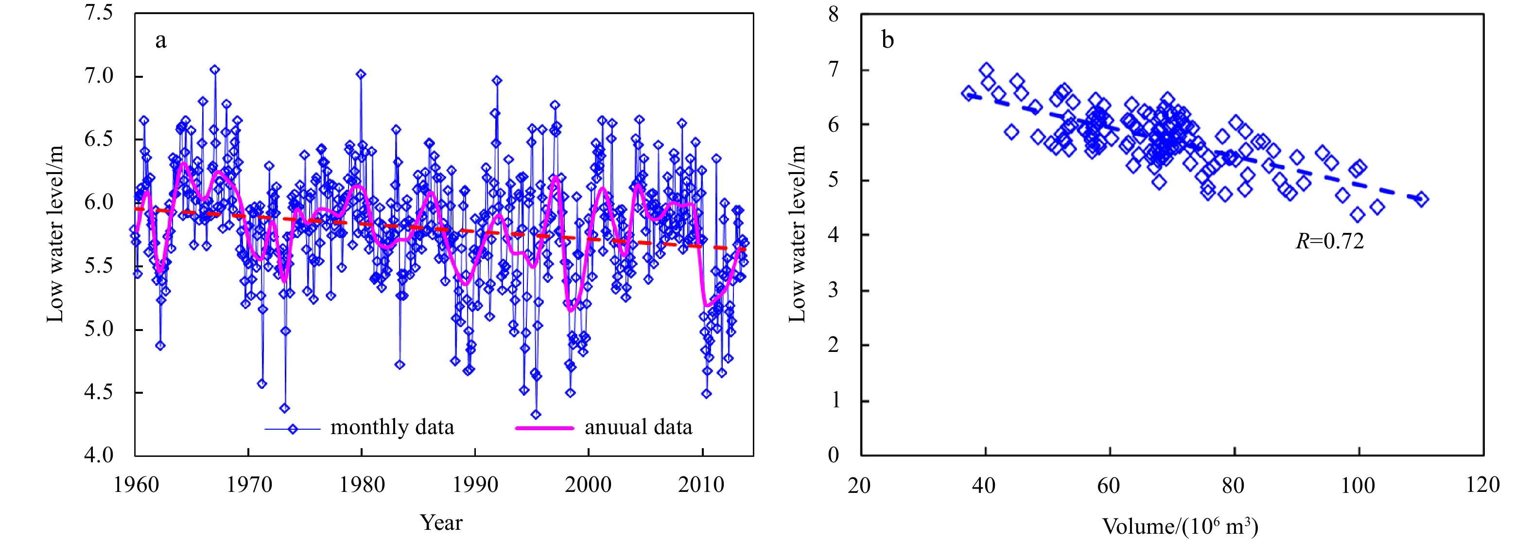
A large sand bar develops in the inner Qiantang River Estuary, China. It is a unique sedimentary system, elongating landwards by about 130 km. Based on long-term series of bathymetric data in each April, July, and November since the 1960s, this study investigated the morphological behavior of this bar under natural conditions and the influence of a large-scale river narrowing project (LRNP) implemented in the last decades. The results show that three timescales, namely the seasonal, interannual and decadal timescales, can be distinguished for the sand bar evolution. The first two are related to the seasonal and interannual variations of river discharge. During high discharge seasons or years, erosion took place at the upper reach and sedimentation at the lower reach. Consequently, the bar apex shifted seaward. The opposite development took place during low discharge seasons or years. The decadal timescale is related to LRNP. Due to the implementation of LRNP, the upper reach has experienced apparent erosion and currently a new equilibrium state has been reached; whereas the lower reach has been accumulated seriously and the accumulation still continues. Nonlinear relationships for how the bar apex location and elevation depend on the river discharge over various stages of LRNP have been established. Compared with the earlier stage of LRNP, the bar apex at present has shifted seaward by about 12 km and lowered by about 1 m. The sand bar movement has significant feedback on the hydrographic conditions along the estuary and has practical implications for coastal management.
A large sand bar develops in the inner Qiantang River Estuary, China. It is a unique sedimentary system, elongating landwards by about 130 km. Based on long-term series of bathymetric data in each April, July, and November since the 1960s, this study investigated the morphological behavior of this bar under natural conditions and the influence of a large-scale river narrowing project (LRNP) implemented in the last decades. The results show that three timescales, namely the seasonal, interannual and decadal timescales, can be distinguished for the sand bar evolution. The first two are related to the seasonal and interannual variations of river discharge. During high discharge seasons or years, erosion took place at the upper reach and sedimentation at the lower reach. Consequently, the bar apex shifted seaward. The opposite development took place during low discharge seasons or years. The decadal timescale is related to LRNP. Due to the implementation of LRNP, the upper reach has experienced apparent erosion and currently a new equilibrium state has been reached; whereas the lower reach has been accumulated seriously and the accumulation still continues. Nonlinear relationships for how the bar apex location and elevation depend on the river discharge over various stages of LRNP have been established. Compared with the earlier stage of LRNP, the bar apex at present has shifted seaward by about 12 km and lowered by about 1 m. The sand bar movement has significant feedback on the hydrographic conditions along the estuary and has practical implications for coastal management.
2022, 41(2): 166-179.
doi: 10.1007/s13131-021-1704-7
Abstract:
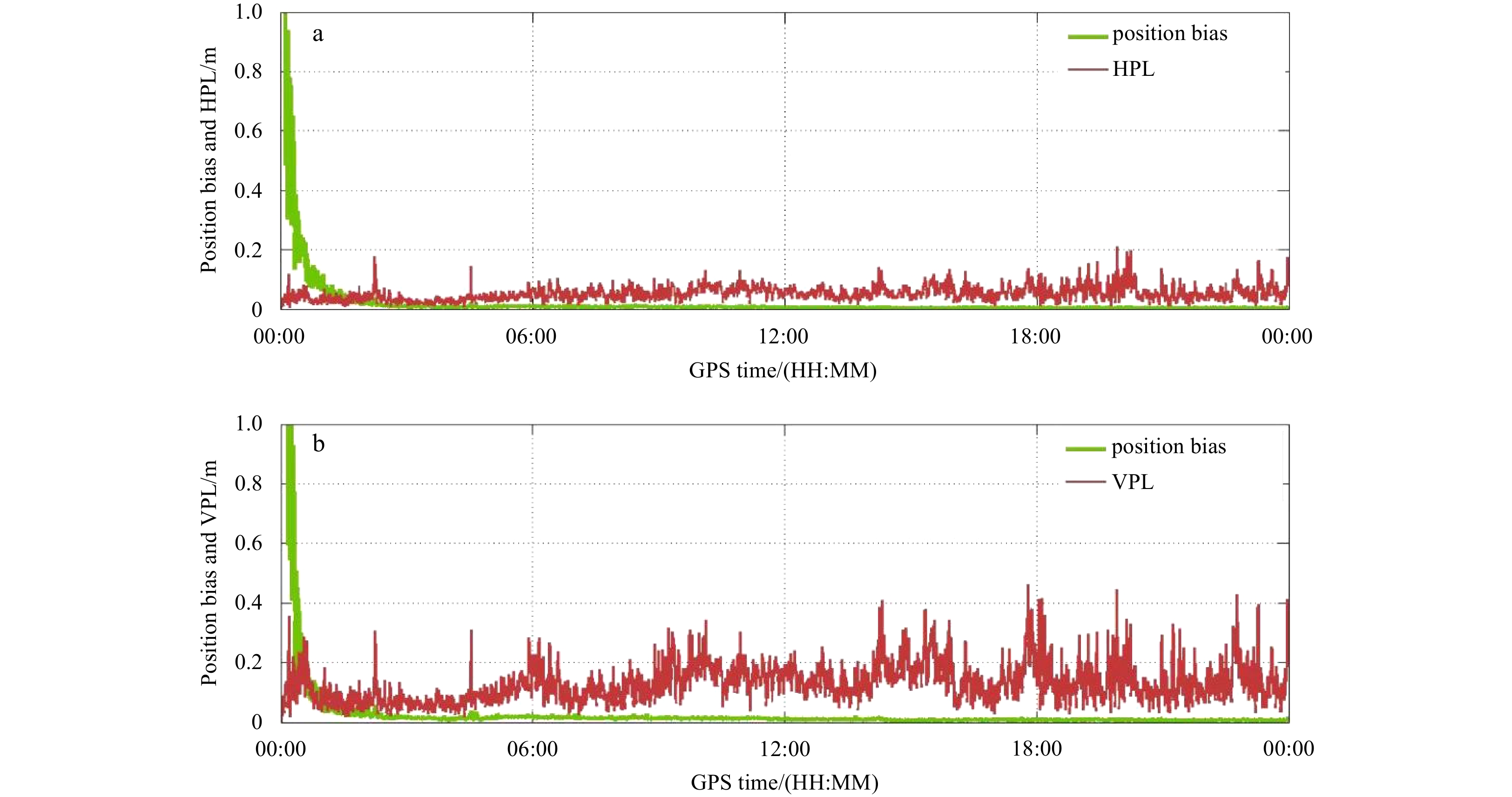
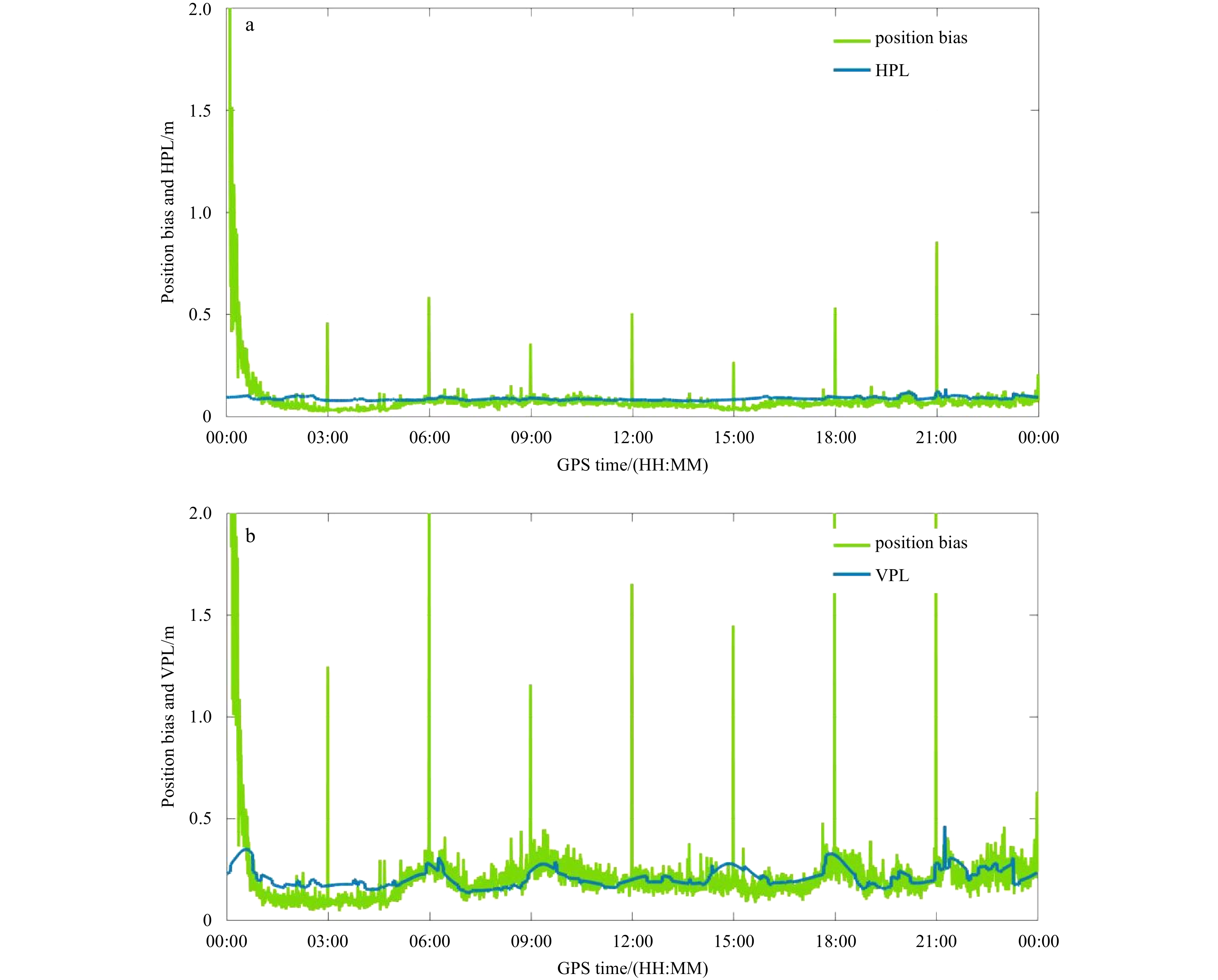
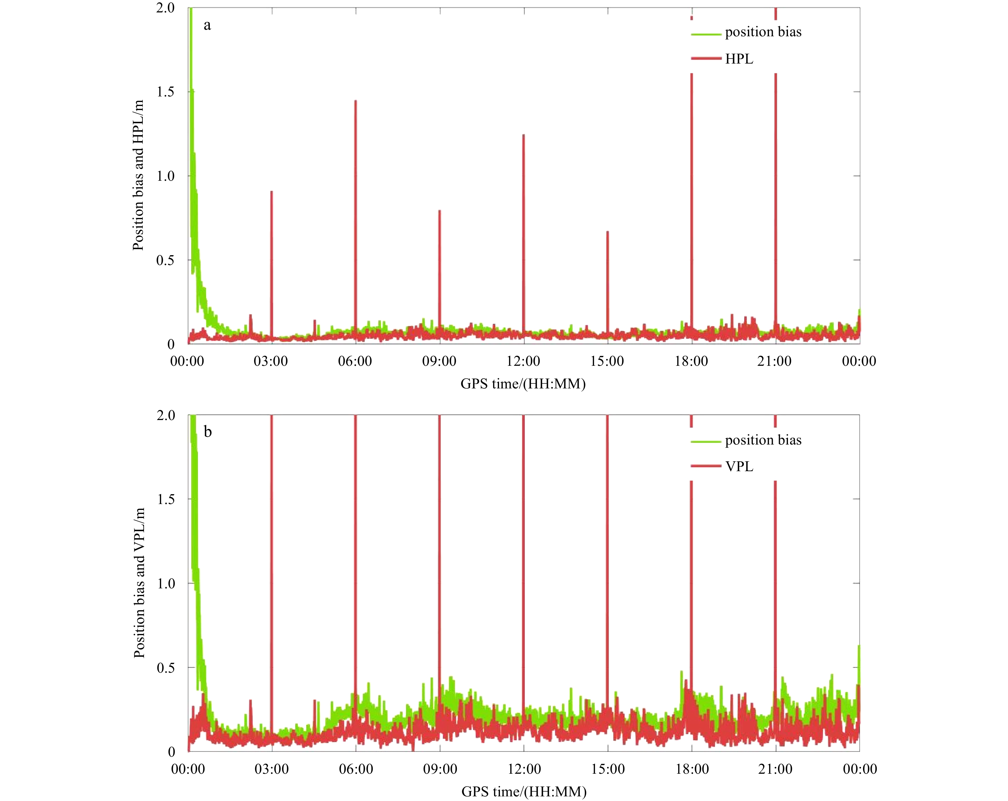
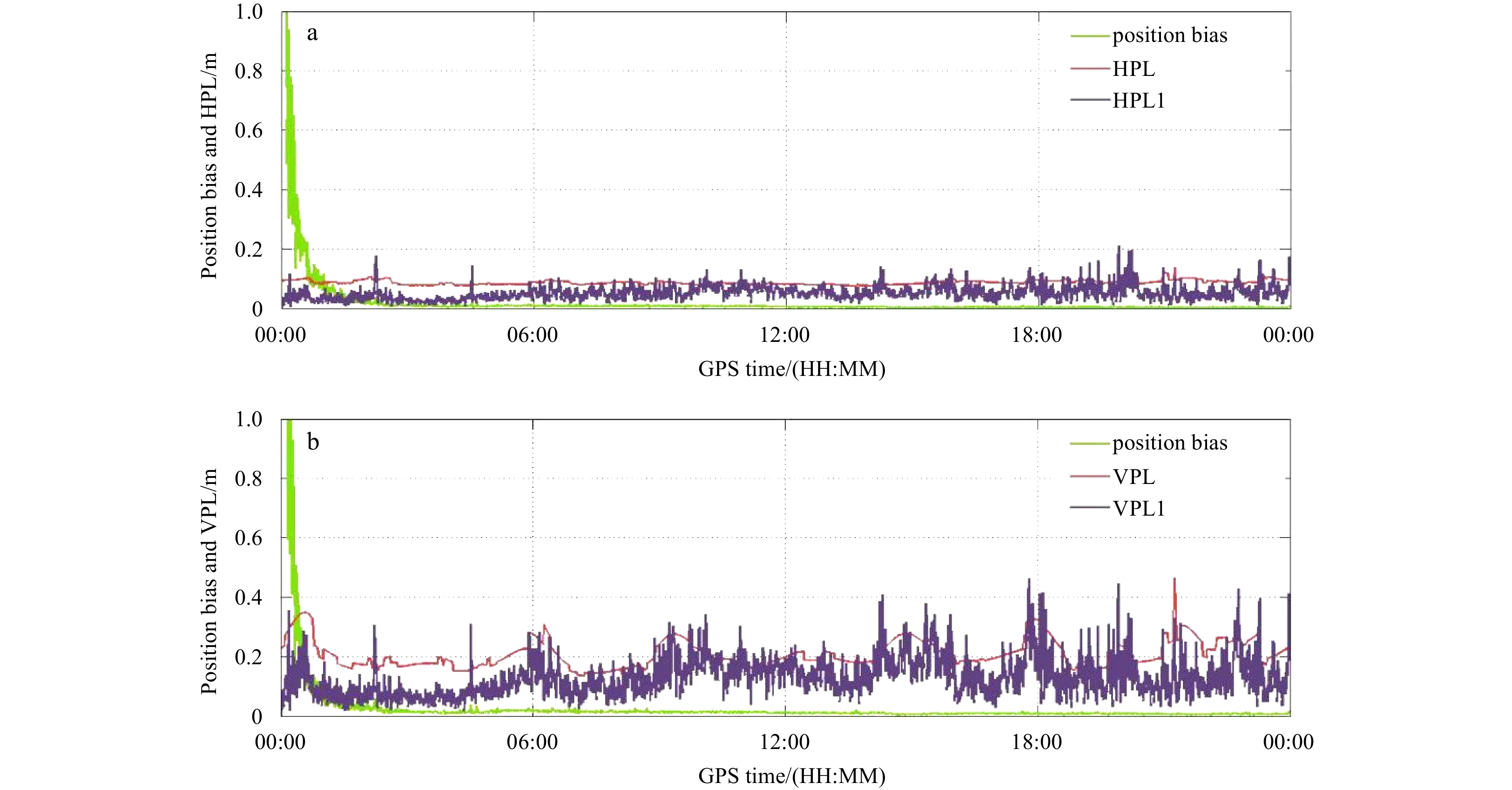
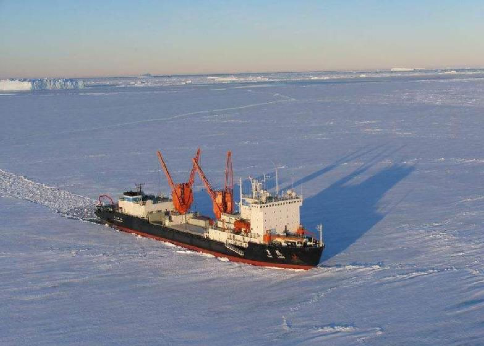
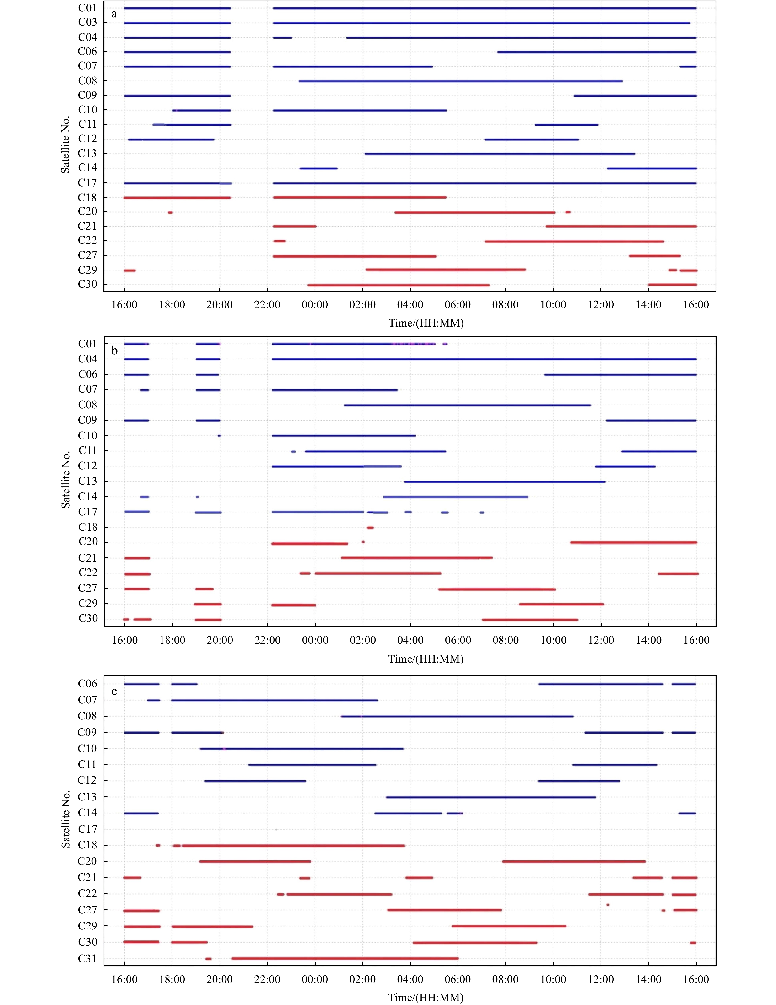
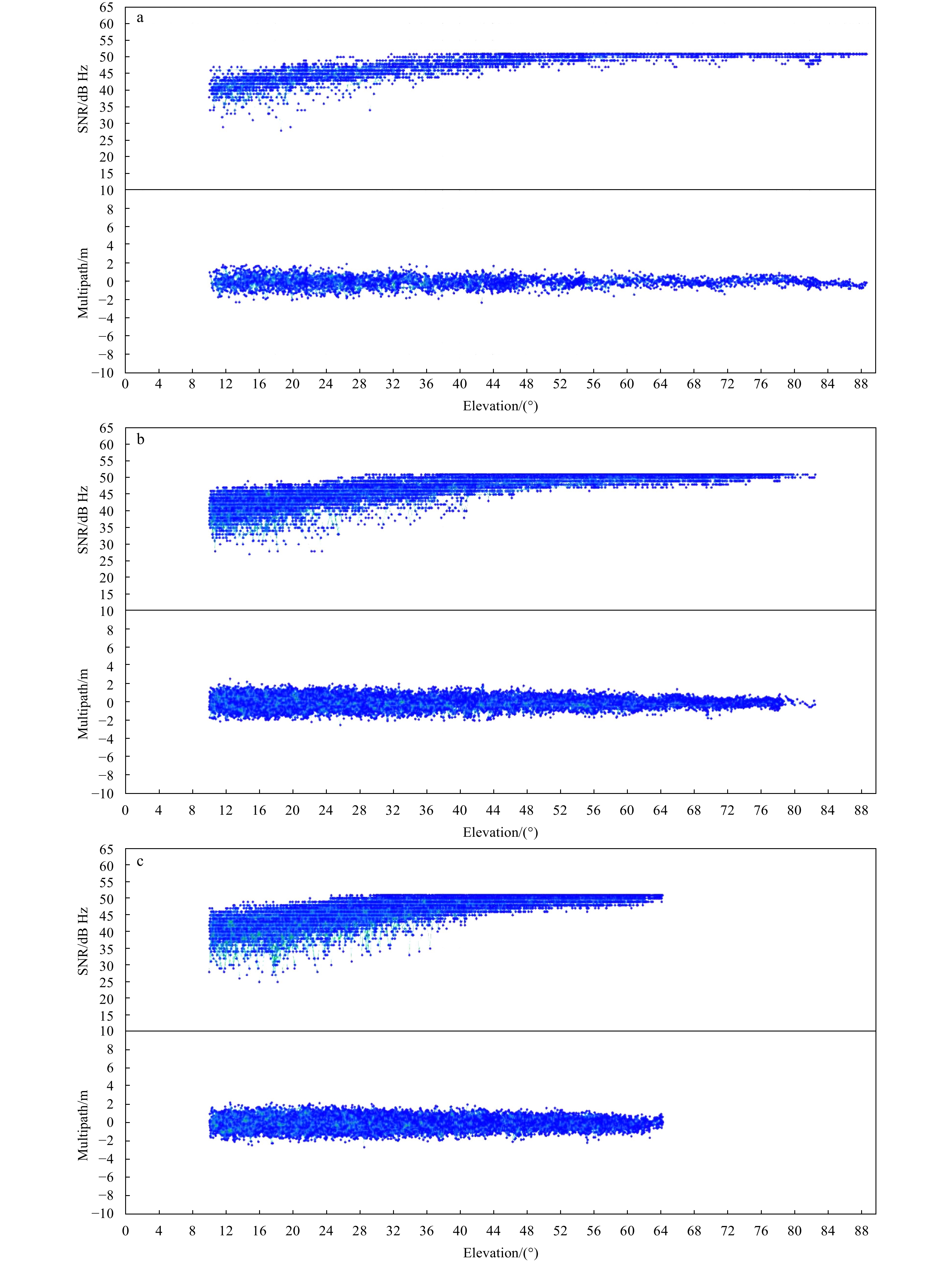
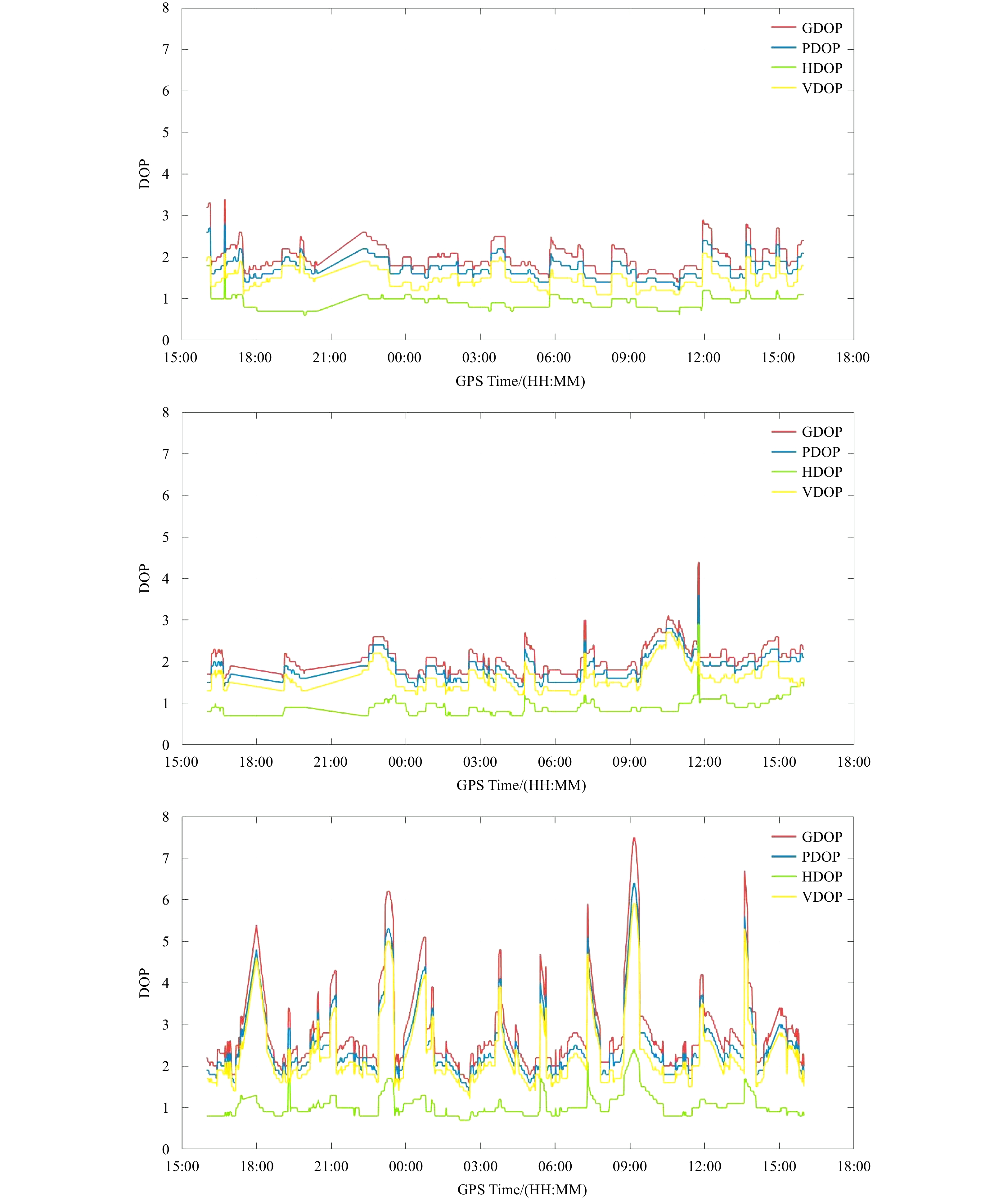
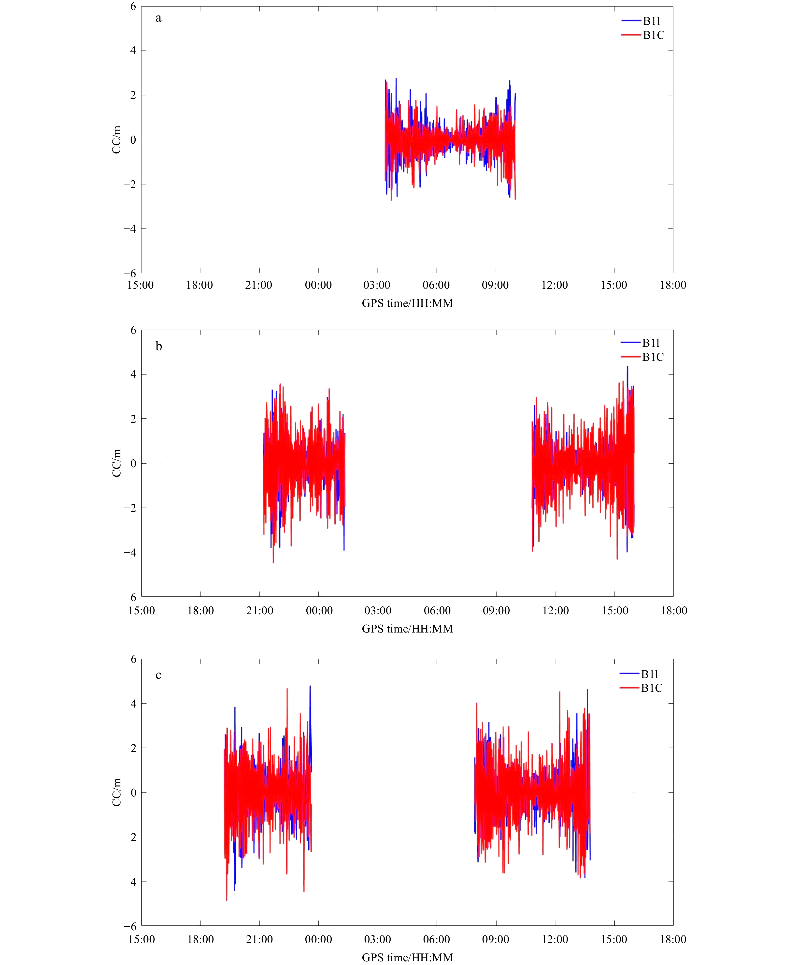
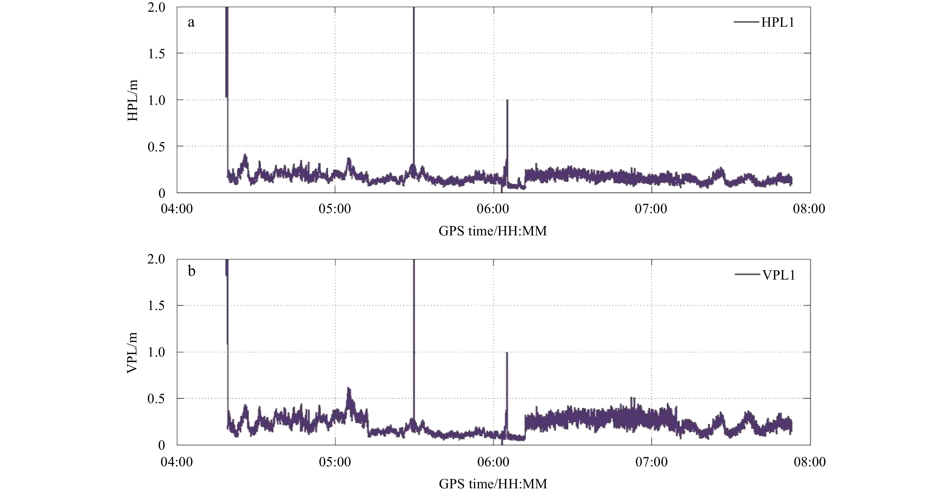
This study analyzes the signal quality and the accuracy of BeiDou 3rd generation Satellite Navigation System (BDS3) Precise Point Positioning (PPP) in the Arctic Ocean. Assessment of signal quality of BDS3 includes signal to noise ratio (SNR), multipath (MP), dilution of precision (DOP), and code-minus-carrier combination (CC). The results show that, 5 to 13 satellites are visible at any time in the Arctic Ocean area as of September 2018, which are sufficient for positioning. In the mid-latitude oceanic region and in the Arctic Ocean, the SNR is 25–52 dB Hz and the MP ranges from −2 m to 2 m. As the latitude increases, the DOP values show large variation, which may be related to the distribution of BDS satellites. The CC values of signals B1I and BIC range from −5 m to 5 m in the mid-latitude sea area and the Arctic Ocean, which means the effect of pseudorange noise is small. Moreover, as to obtain the external precise reference value for GNSS positioning in the Arctic Ocean region is difficult, it is hard to evaluate the accuracy of positioning results. An improved isotropy-based protection level method based on Receiver Autonomous Integrity Monitoring is proposed in the paper, which adopts median filter to smooth the gross errors to assess the precision and reliability of PPP in the Arctic Ocean. At first, the improved algorithm is verified with the data from the International GNSS Service Station Tixi. Then the accuracy of BDS3 PPP in the Arctic Ocean is calculated based on the improved algorithm. Which shows that the kinematic accuracy of PPP can reach the decimeter level in both the horizontal and vertical directions, and it meets the precision requirements of maritime navigation.
This study analyzes the signal quality and the accuracy of BeiDou 3rd generation Satellite Navigation System (BDS3) Precise Point Positioning (PPP) in the Arctic Ocean. Assessment of signal quality of BDS3 includes signal to noise ratio (SNR), multipath (MP), dilution of precision (DOP), and code-minus-carrier combination (CC). The results show that, 5 to 13 satellites are visible at any time in the Arctic Ocean area as of September 2018, which are sufficient for positioning. In the mid-latitude oceanic region and in the Arctic Ocean, the SNR is 25–52 dB Hz and the MP ranges from −2 m to 2 m. As the latitude increases, the DOP values show large variation, which may be related to the distribution of BDS satellites. The CC values of signals B1I and BIC range from −5 m to 5 m in the mid-latitude sea area and the Arctic Ocean, which means the effect of pseudorange noise is small. Moreover, as to obtain the external precise reference value for GNSS positioning in the Arctic Ocean region is difficult, it is hard to evaluate the accuracy of positioning results. An improved isotropy-based protection level method based on Receiver Autonomous Integrity Monitoring is proposed in the paper, which adopts median filter to smooth the gross errors to assess the precision and reliability of PPP in the Arctic Ocean. At first, the improved algorithm is verified with the data from the International GNSS Service Station Tixi. Then the accuracy of BDS3 PPP in the Arctic Ocean is calculated based on the improved algorithm. Which shows that the kinematic accuracy of PPP can reach the decimeter level in both the horizontal and vertical directions, and it meets the precision requirements of maritime navigation.