2023 Vol. 42, No. 2
Display Method:
2023, 42(2): 1-2.
Abstract:
2023, 42(2): 1-16.
doi: 10.1007/s13131-022-2076-3
Abstract:
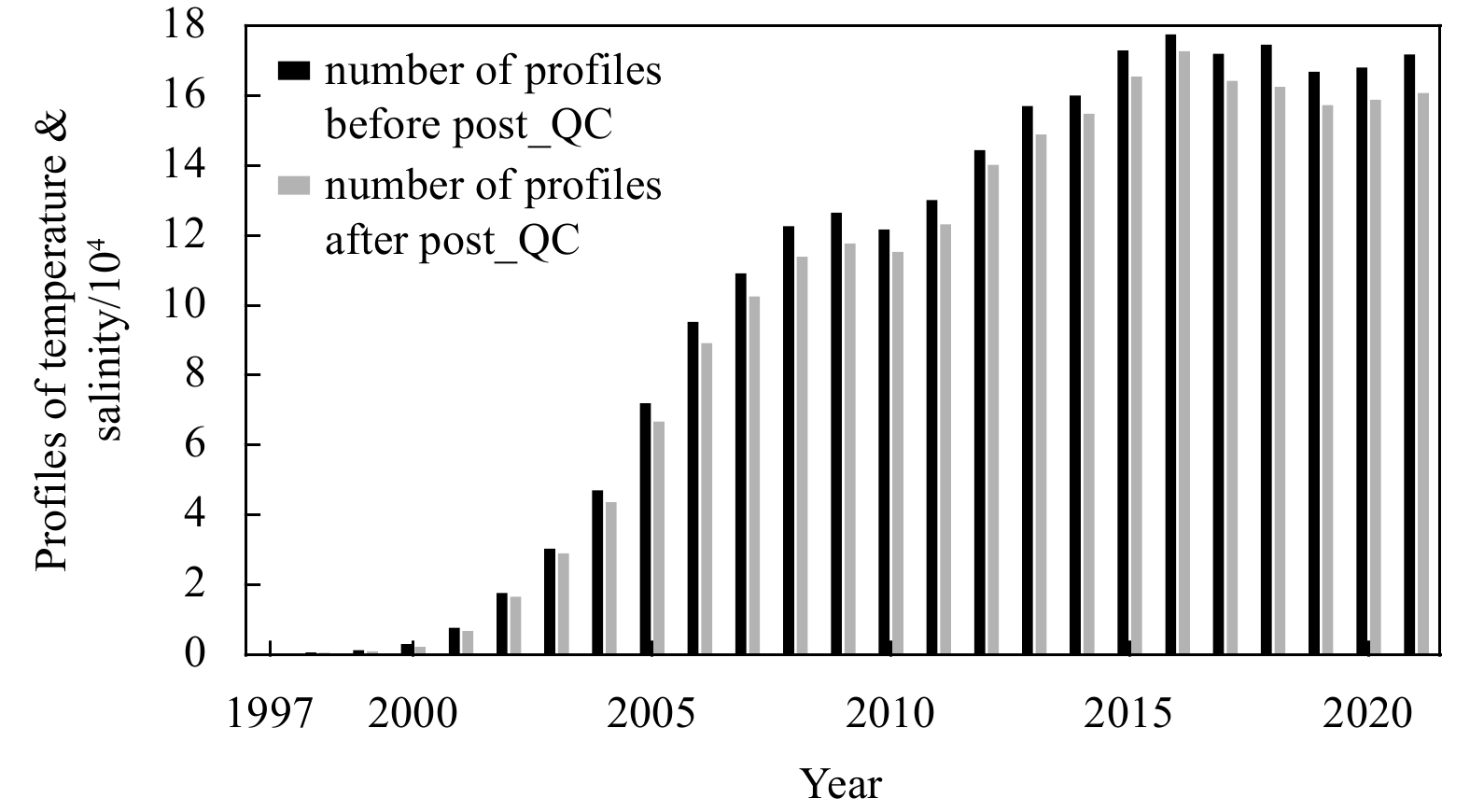
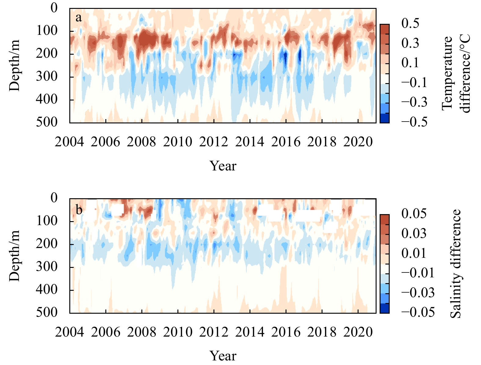
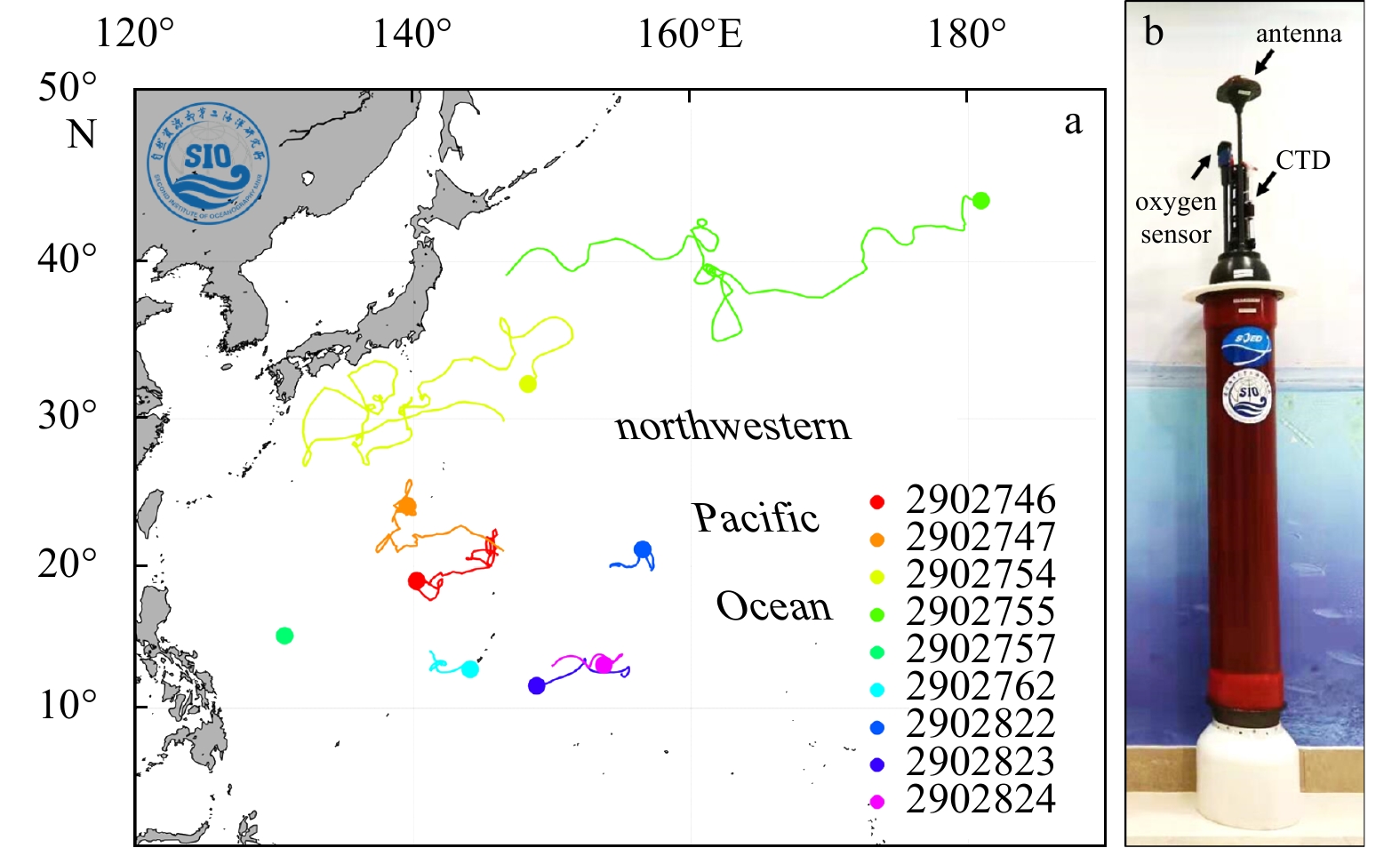
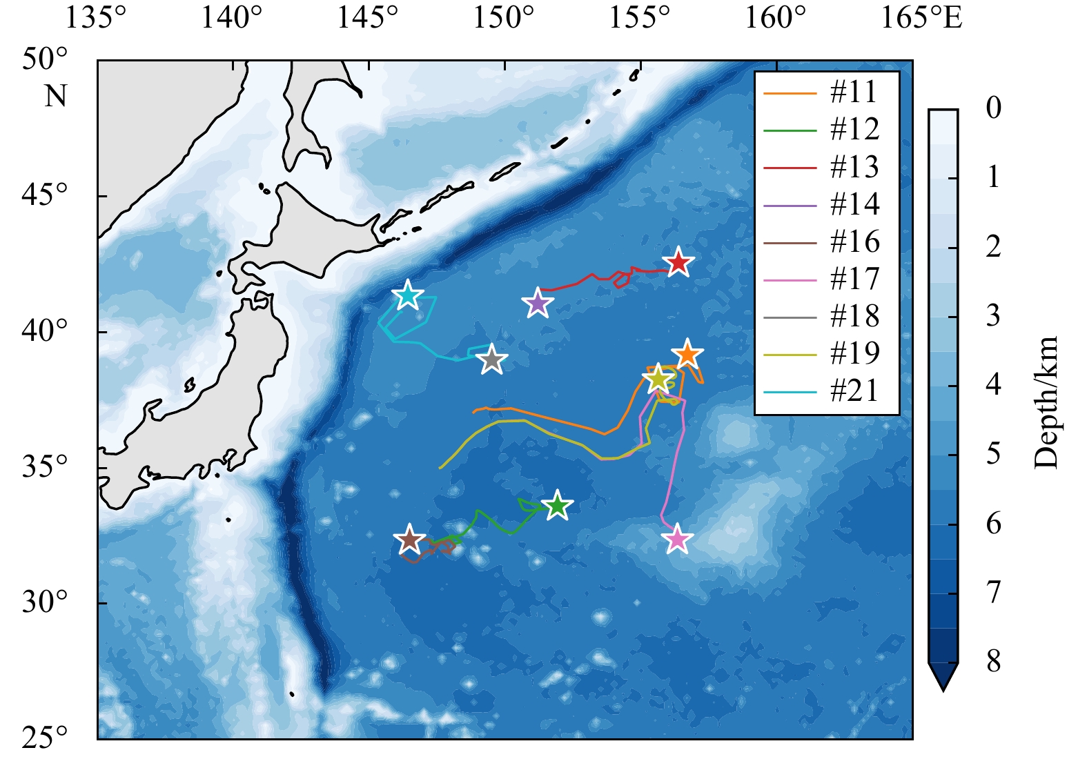
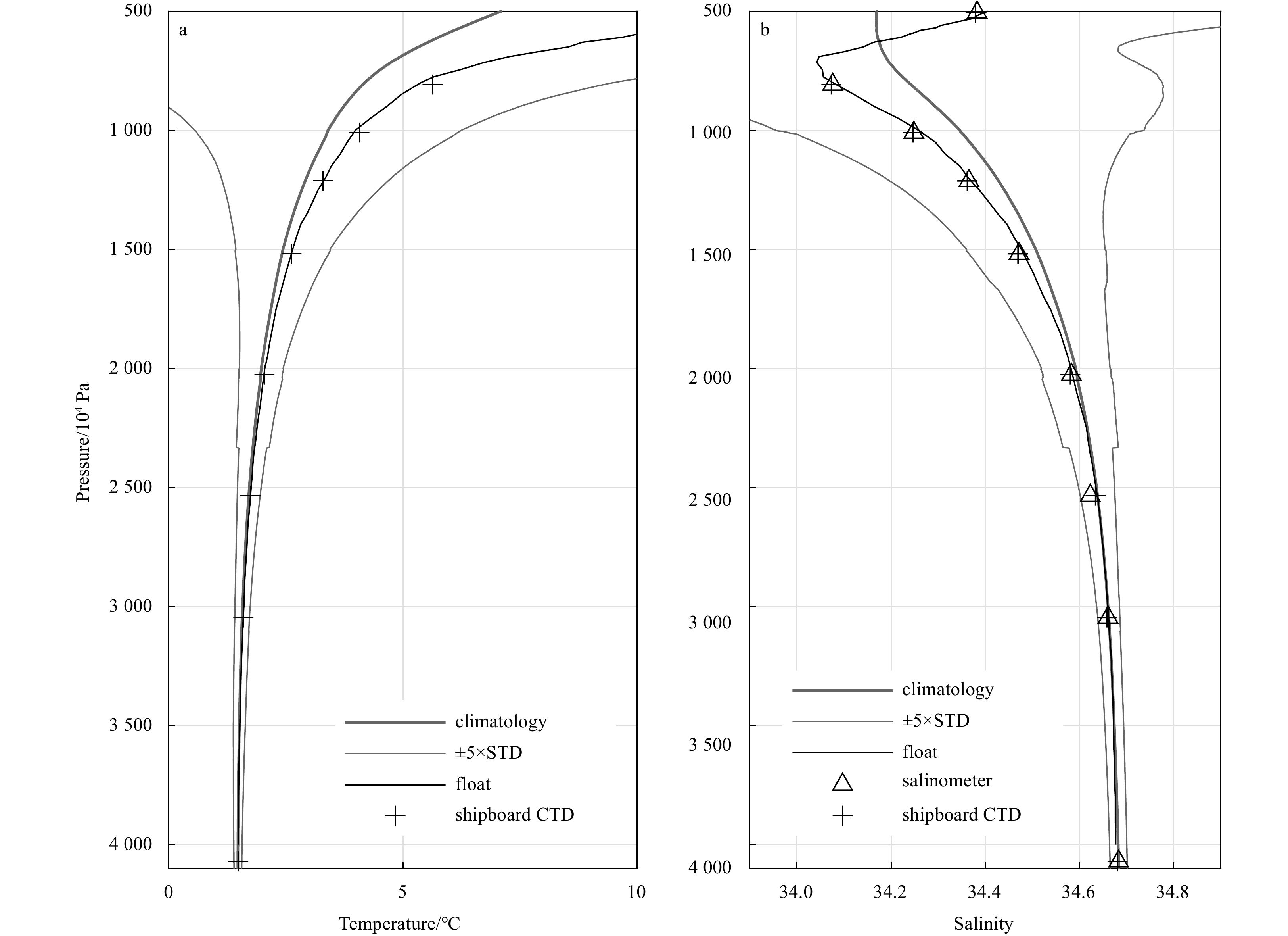
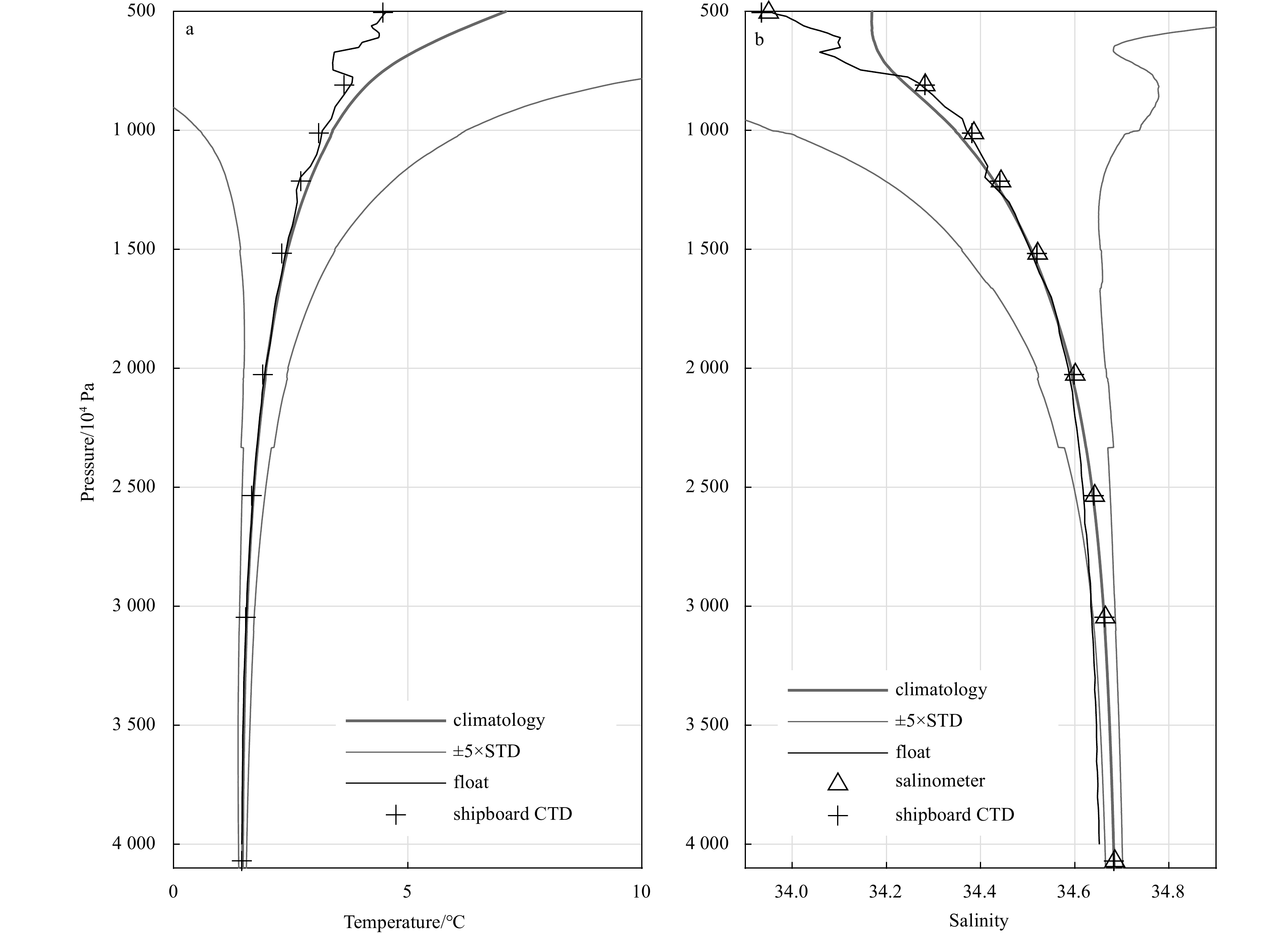
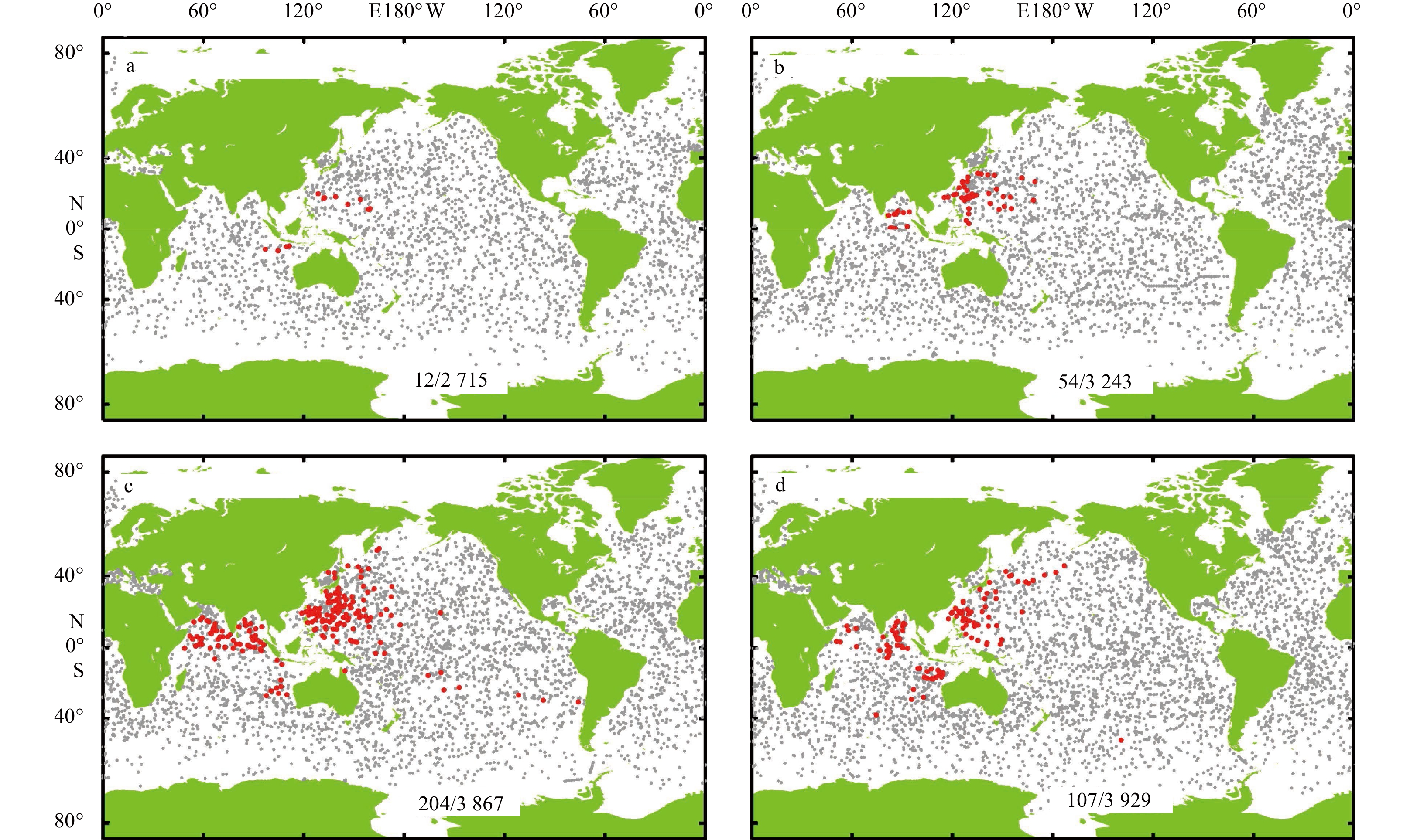
The international Argo program, a global observational array of nearly 4 000 autonomous profiling floats initiated in the late 1990s, which measures the water temperature and salinity of the upper 2 000 m of the global ocean, has revolutionized oceanography. It has been recognized one of the most successful ocean observation systems in the world. Today, the proposed decade action “OneArgo” for building an integrated global, full-depth, and multidisciplinary ocean observing array for beyond 2020 has been endorsed. In the past two decades since 2002, with more than 500 Argo deployments and 80 operational floats currently, China has become an important partner of the Argo program. Two DACs have been established to process the data reported from all Chinese floats and deliver these data to the GDACs in real time, adhering to the unified quality control procedures proposed by the Argo Data Management Team. Several Argo products have been developed and released, allowing accurate estimations of global ocean warming, sea level change and the hydrological cycle, at interannual to decadal scales. In addition, Deep and BGC-Argo floats have been deployed, and time series observations from these floats have proven to be extremely useful, particularly in the analysis of synoptic-scale to decadal-scale dynamics. The future aim of China Argo is to build and maintain a regional Argo fleet comprising approximately 400 floats in the northwestern Pacific, South China Sea, and Indian Ocean, accounting for 9% of the global fleet, in addition to maintaining 300 Deep Argo floats in the global ocean (25% of the global Deep Argo fleet). A regional BGC-Argo array in the western Pacific also needs to be established and maintained.
The international Argo program, a global observational array of nearly 4 000 autonomous profiling floats initiated in the late 1990s, which measures the water temperature and salinity of the upper 2 000 m of the global ocean, has revolutionized oceanography. It has been recognized one of the most successful ocean observation systems in the world. Today, the proposed decade action “OneArgo” for building an integrated global, full-depth, and multidisciplinary ocean observing array for beyond 2020 has been endorsed. In the past two decades since 2002, with more than 500 Argo deployments and 80 operational floats currently, China has become an important partner of the Argo program. Two DACs have been established to process the data reported from all Chinese floats and deliver these data to the GDACs in real time, adhering to the unified quality control procedures proposed by the Argo Data Management Team. Several Argo products have been developed and released, allowing accurate estimations of global ocean warming, sea level change and the hydrological cycle, at interannual to decadal scales. In addition, Deep and BGC-Argo floats have been deployed, and time series observations from these floats have proven to be extremely useful, particularly in the analysis of synoptic-scale to decadal-scale dynamics. The future aim of China Argo is to build and maintain a regional Argo fleet comprising approximately 400 floats in the northwestern Pacific, South China Sea, and Indian Ocean, accounting for 9% of the global fleet, in addition to maintaining 300 Deep Argo floats in the global ocean (25% of the global Deep Argo fleet). A regional BGC-Argo array in the western Pacific also needs to be established and maintained.


2023, 42(2): 17-28.
doi: 10.1007/s13131-021-1964-2
Abstract:
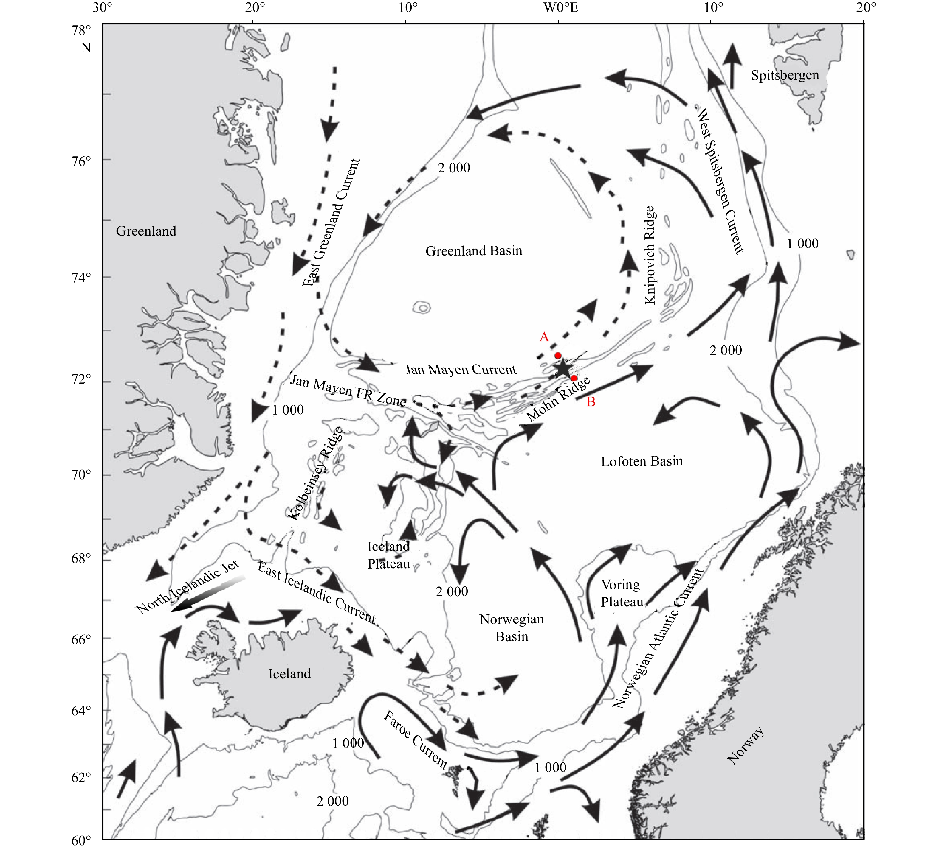
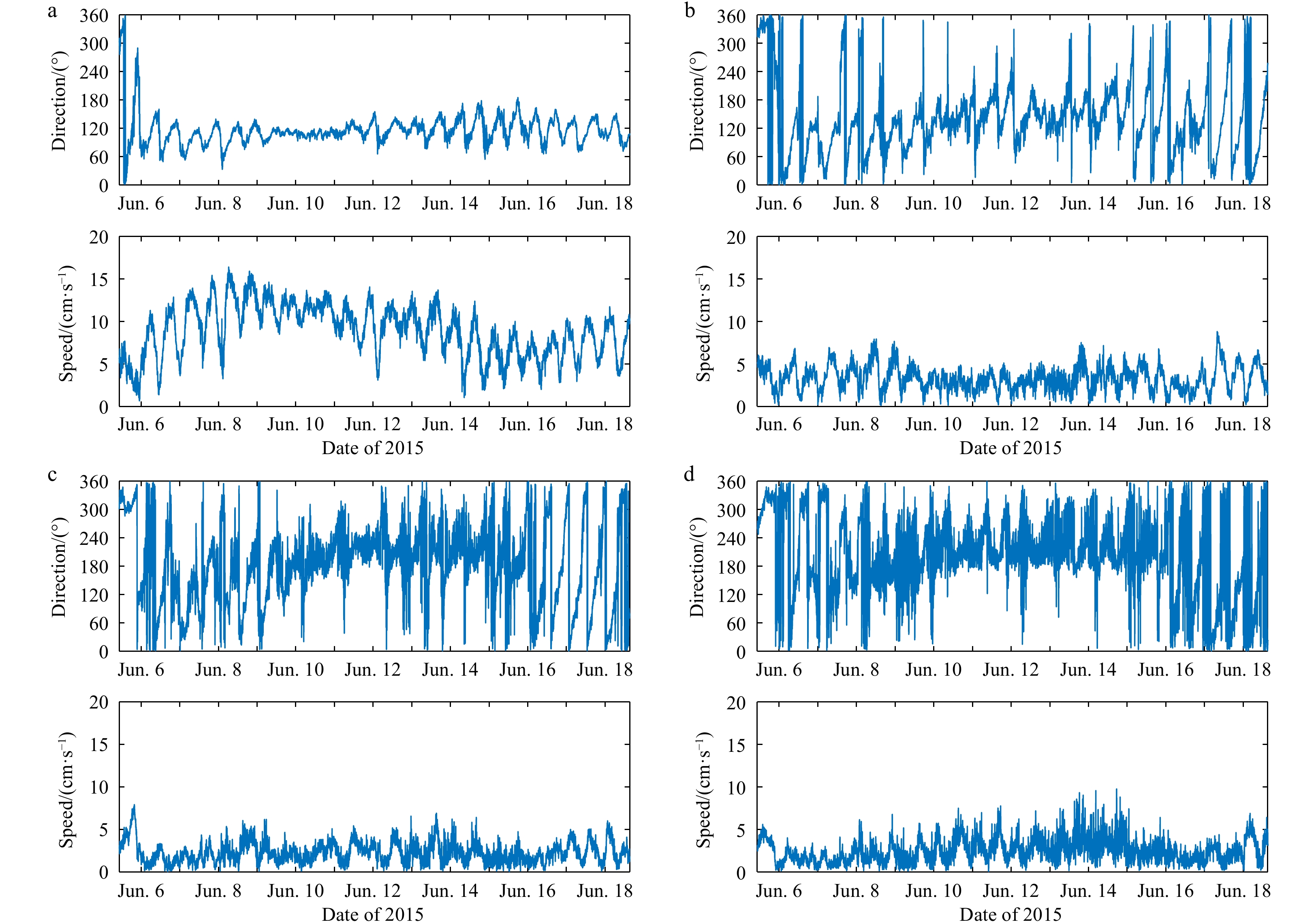
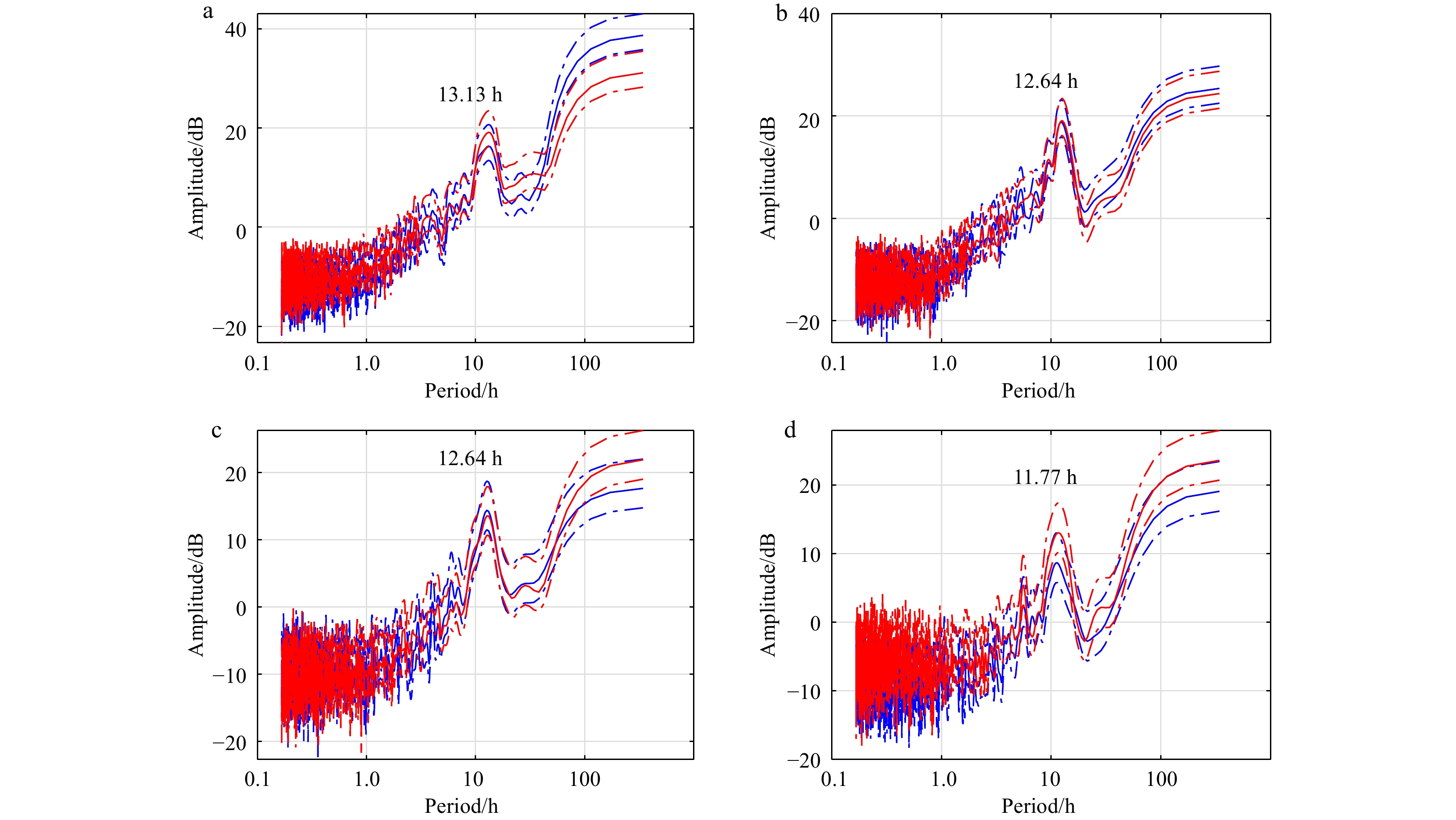
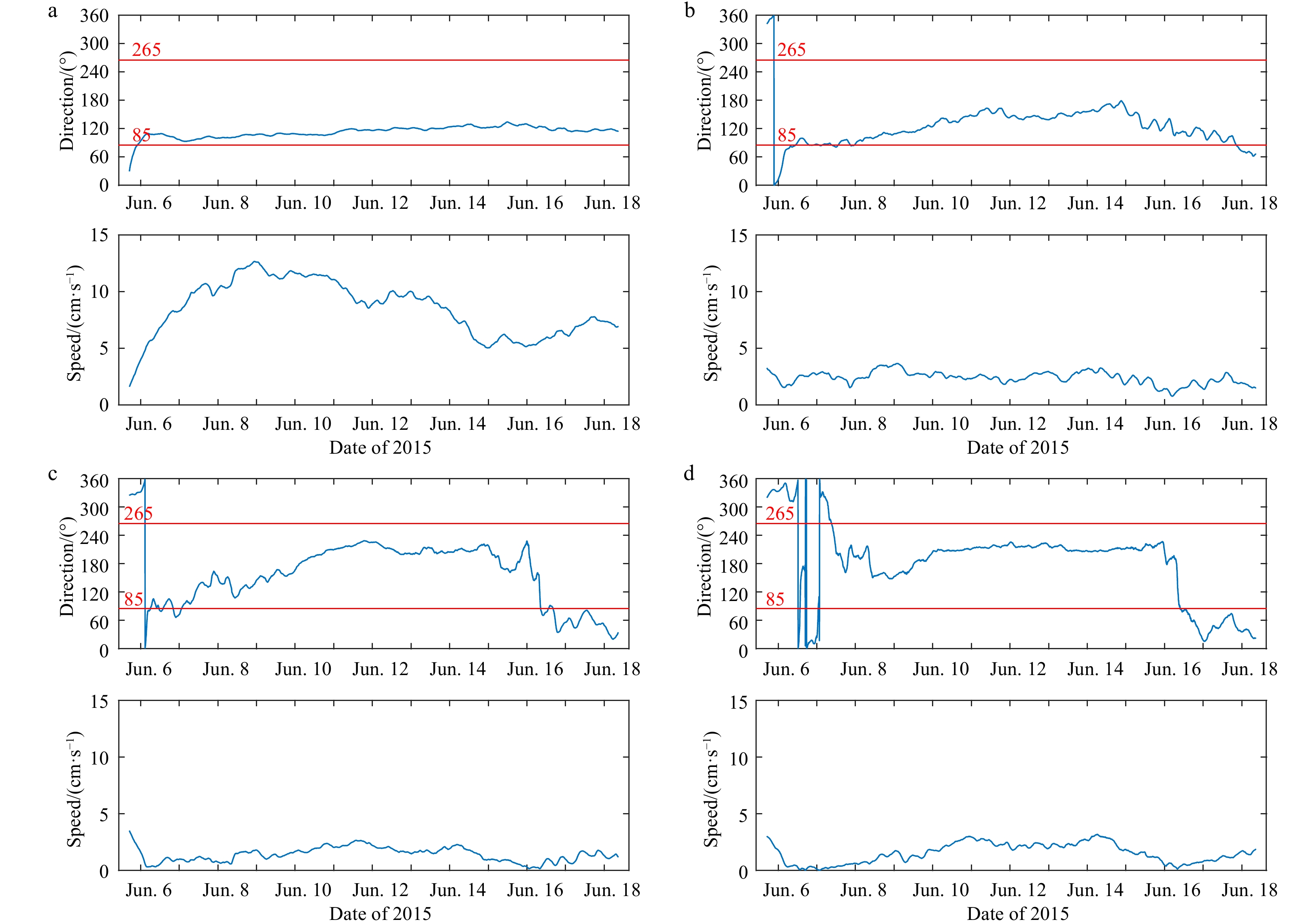
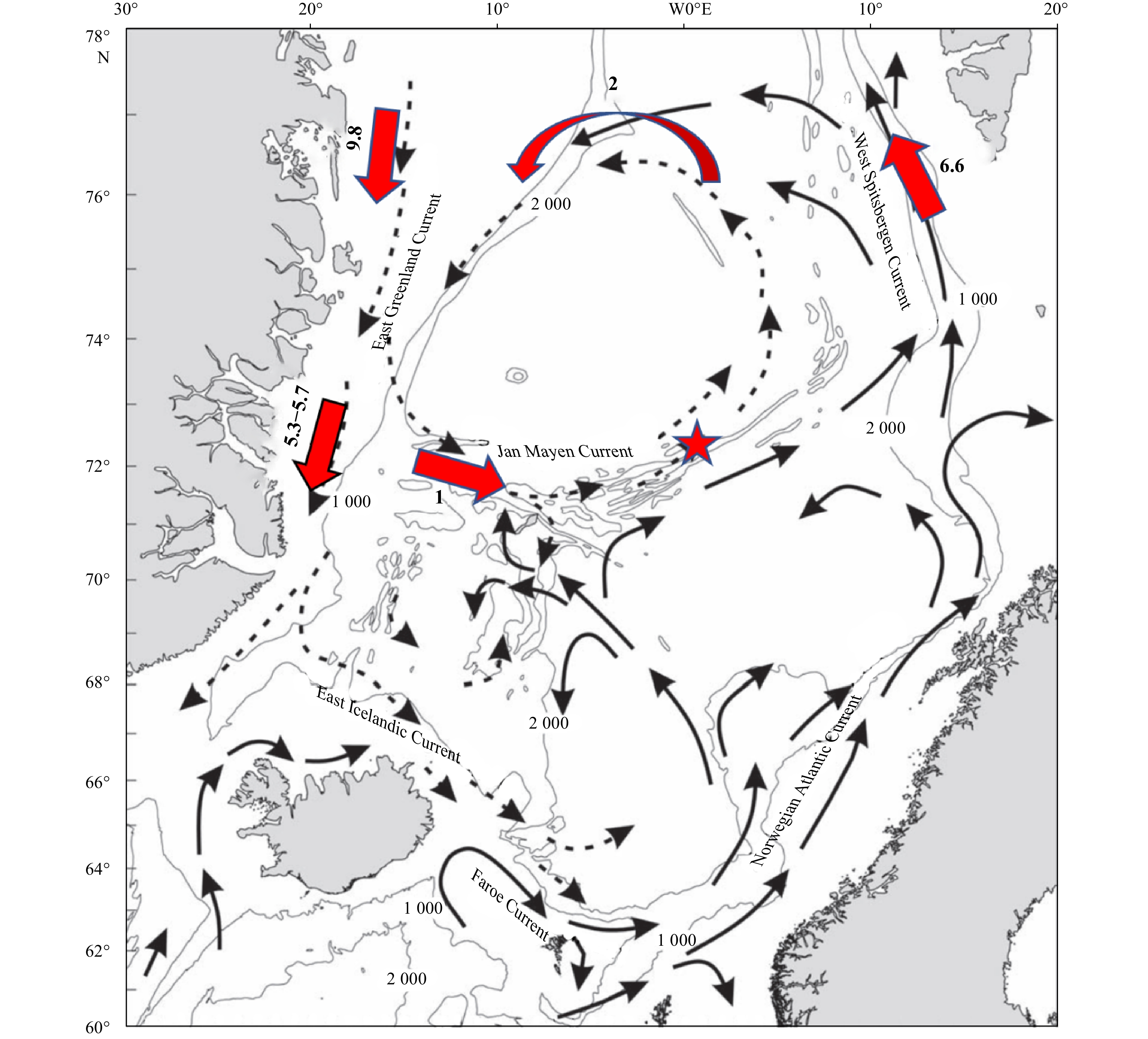
The Mohn Ridge separates the Greenland Sea and the Lofoten Basin. Previous studies identified the export across the Mohn Ridge (EMR) from the Greenland Basin into the Lofoten Basin using water mass analysis and the tracer diffusion method, but there is still lack of direct current measurements. A surface mooring with four current meters was deployed on the Mohn Ridge from June 5 to June 18 in 2015, when three cyclones passed in the adjacent area. In the absence of cyclones, the flow on the Mohn Ridge was northeastward, parallel to the ridge. When cyclones appeared, the EMR occurred to transport Greenland Sea water into the Lofoten Basin. The probable mechanism is the sea level height variation caused by the perturbation of the low pressure of cyclones, which yields an outward pressure gradient force to drive the outflow. Our results suggest that the outflow is intermittent and only happens during cyclone activities. The annual mean volume flux of EMR was roughly estimated by the limited data, which is about 3.8×10⁶ m3/s, a little bit smaller than the estimation based on volume conservation. The results indicate that the contribution of the cyclonic storms to EMR is a greatly important mechanism that potentially influences the global thermohaline circulation through the Greenland-Scotland Ridge overflow.
The Mohn Ridge separates the Greenland Sea and the Lofoten Basin. Previous studies identified the export across the Mohn Ridge (EMR) from the Greenland Basin into the Lofoten Basin using water mass analysis and the tracer diffusion method, but there is still lack of direct current measurements. A surface mooring with four current meters was deployed on the Mohn Ridge from June 5 to June 18 in 2015, when three cyclones passed in the adjacent area. In the absence of cyclones, the flow on the Mohn Ridge was northeastward, parallel to the ridge. When cyclones appeared, the EMR occurred to transport Greenland Sea water into the Lofoten Basin. The probable mechanism is the sea level height variation caused by the perturbation of the low pressure of cyclones, which yields an outward pressure gradient force to drive the outflow. Our results suggest that the outflow is intermittent and only happens during cyclone activities. The annual mean volume flux of EMR was roughly estimated by the limited data, which is about 3.8×10⁶ m3/s, a little bit smaller than the estimation based on volume conservation. The results indicate that the contribution of the cyclonic storms to EMR is a greatly important mechanism that potentially influences the global thermohaline circulation through the Greenland-Scotland Ridge overflow.


2023, 42(2): 29-43.
doi: 10.1007/s13131-022-2068-3
Abstract:
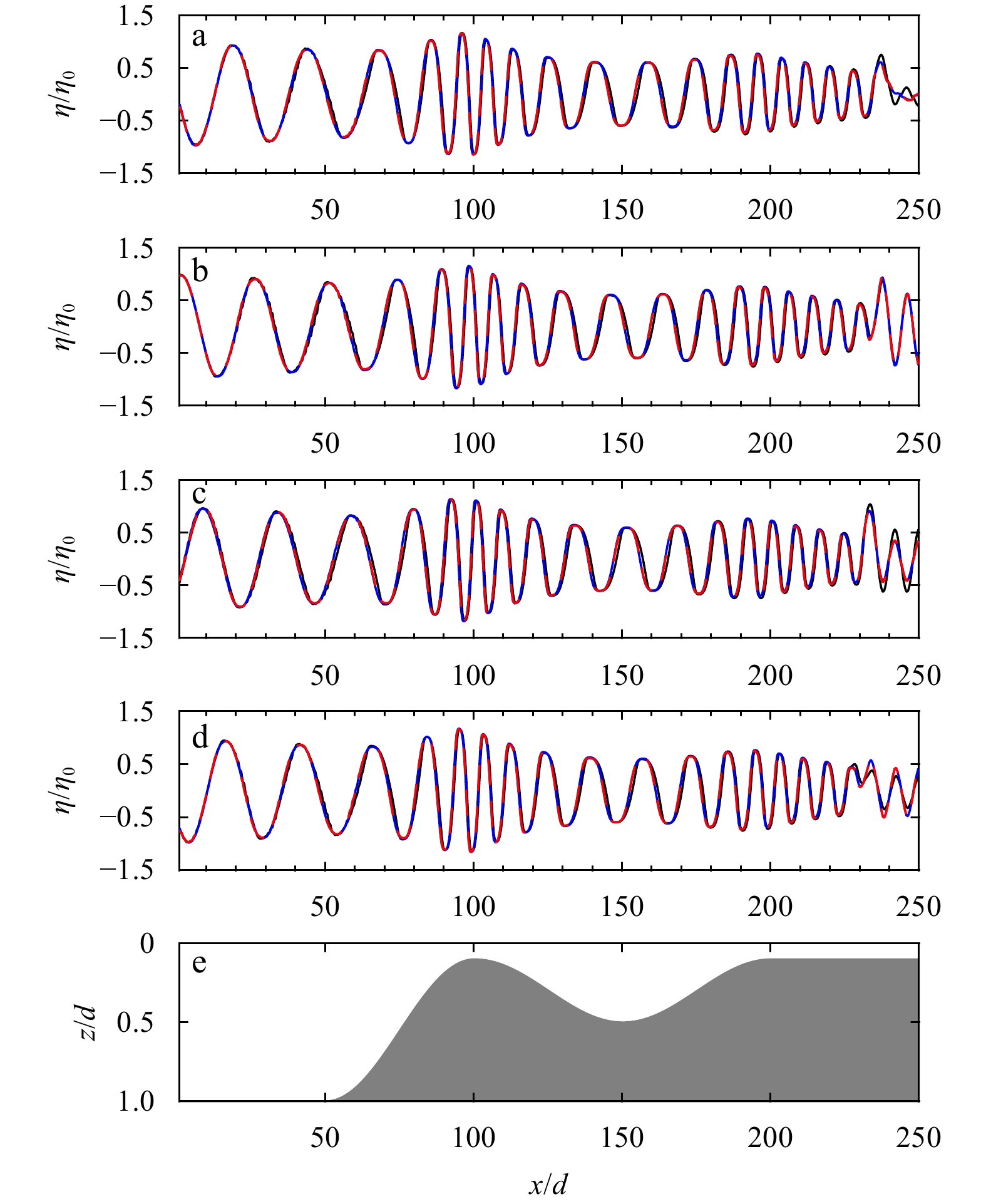
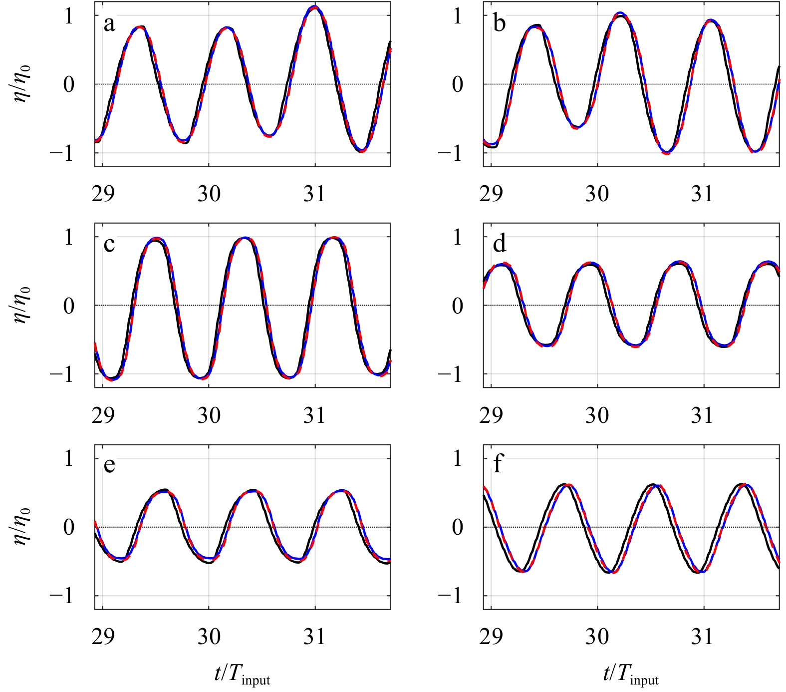
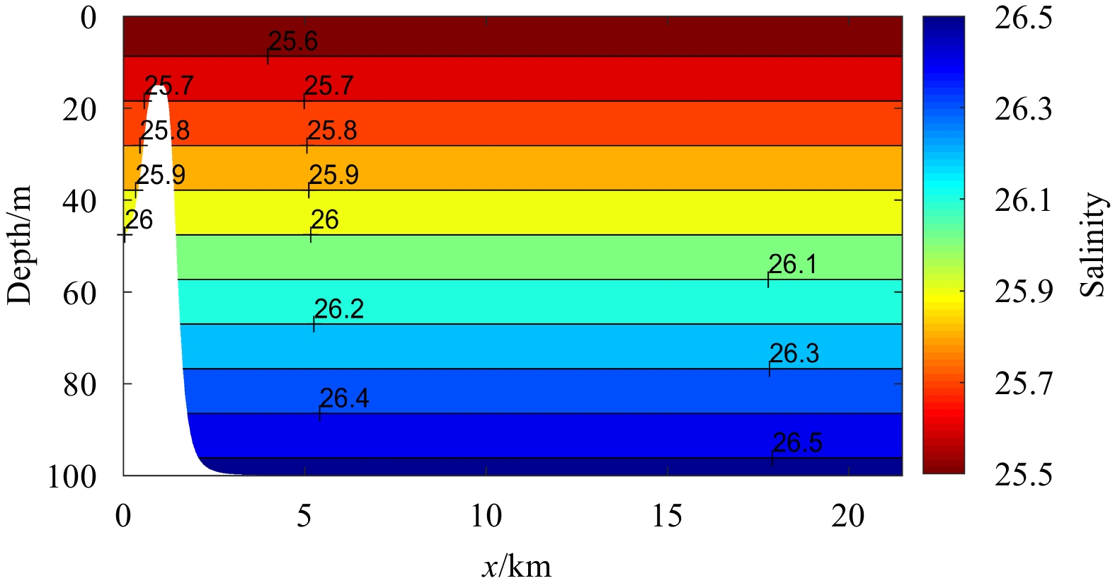
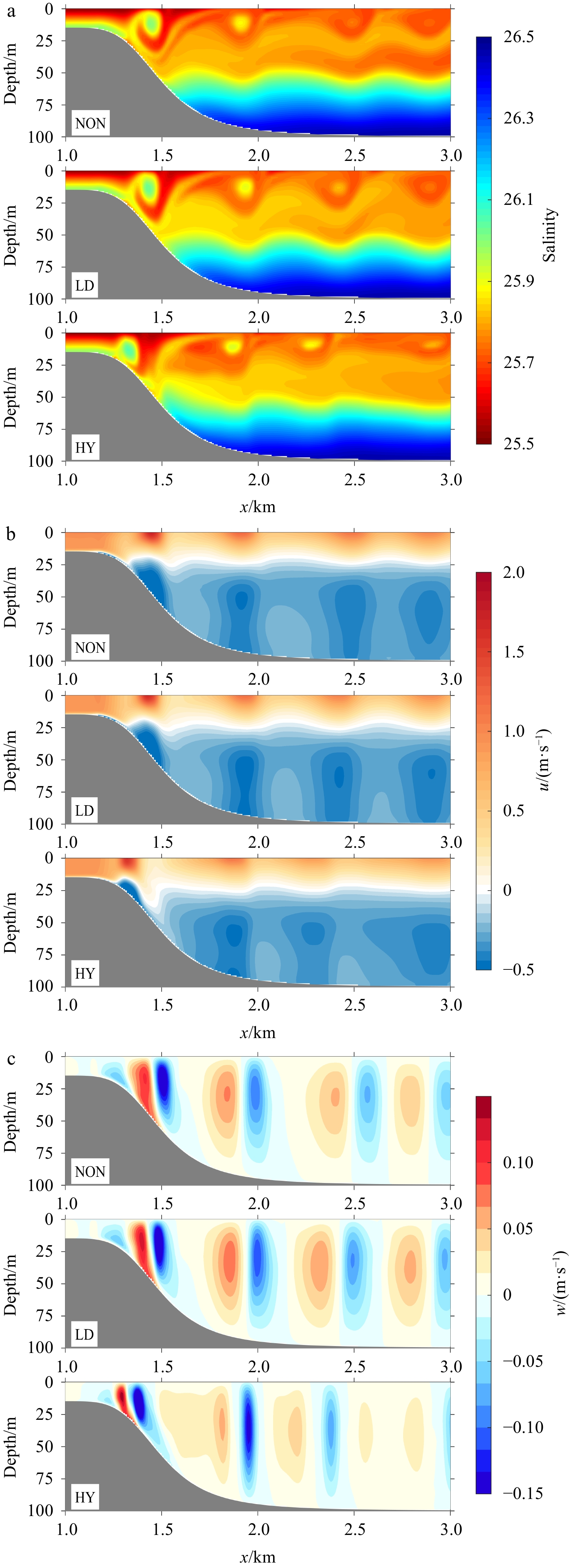
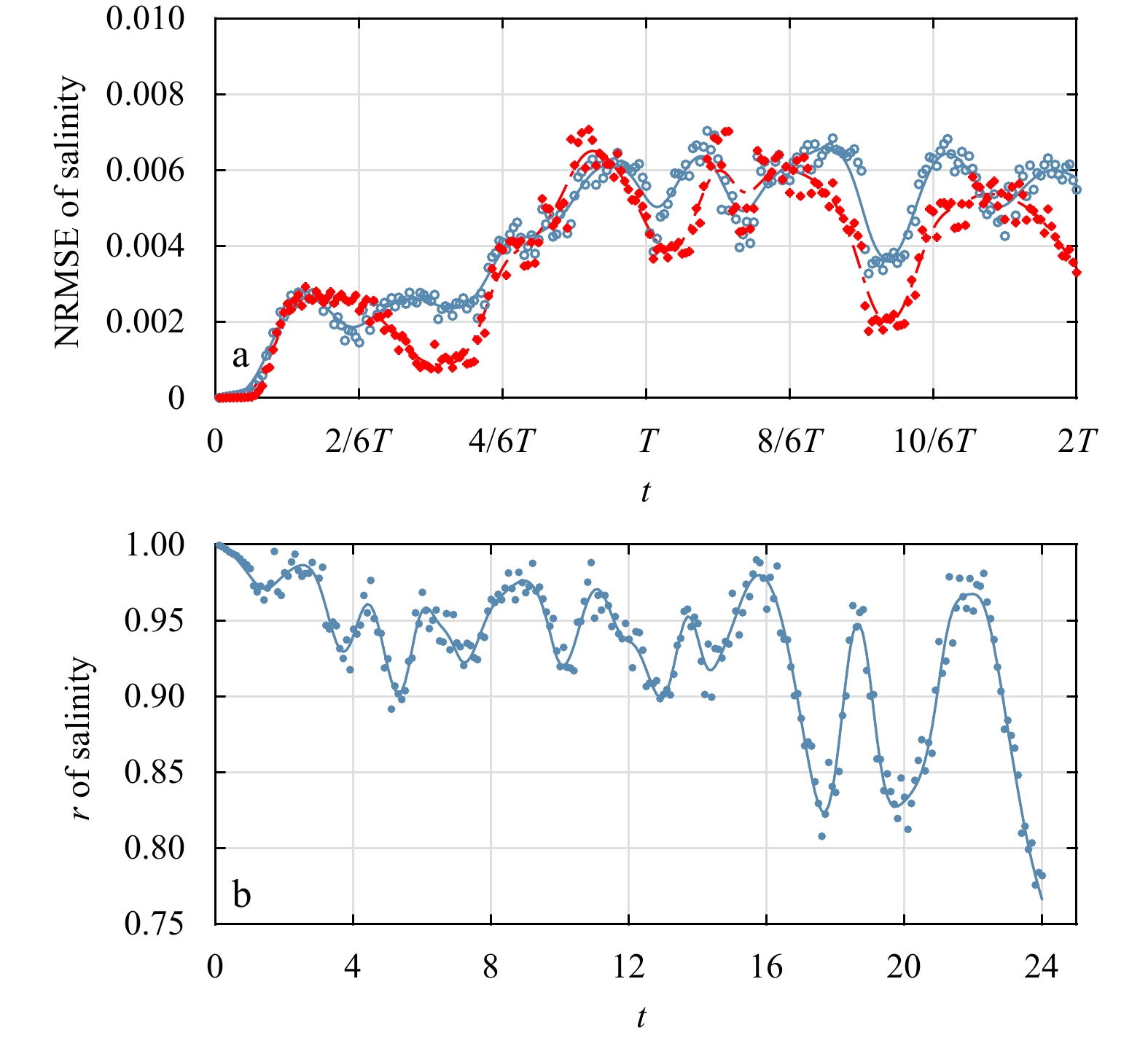
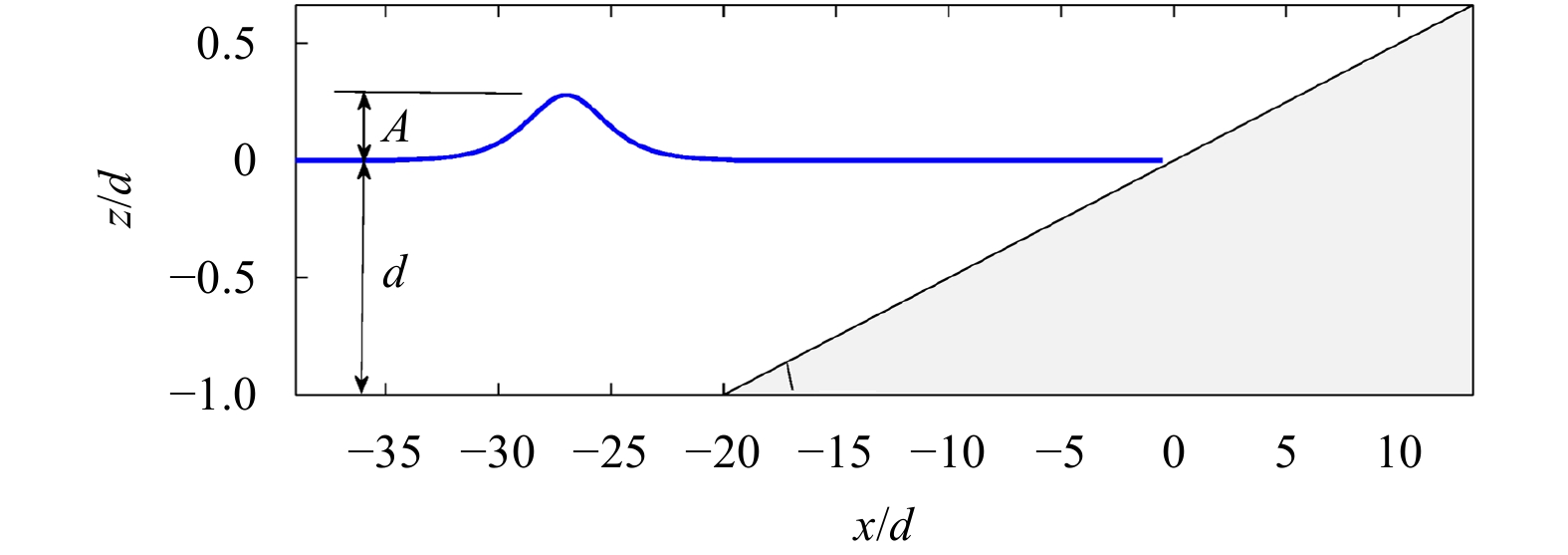
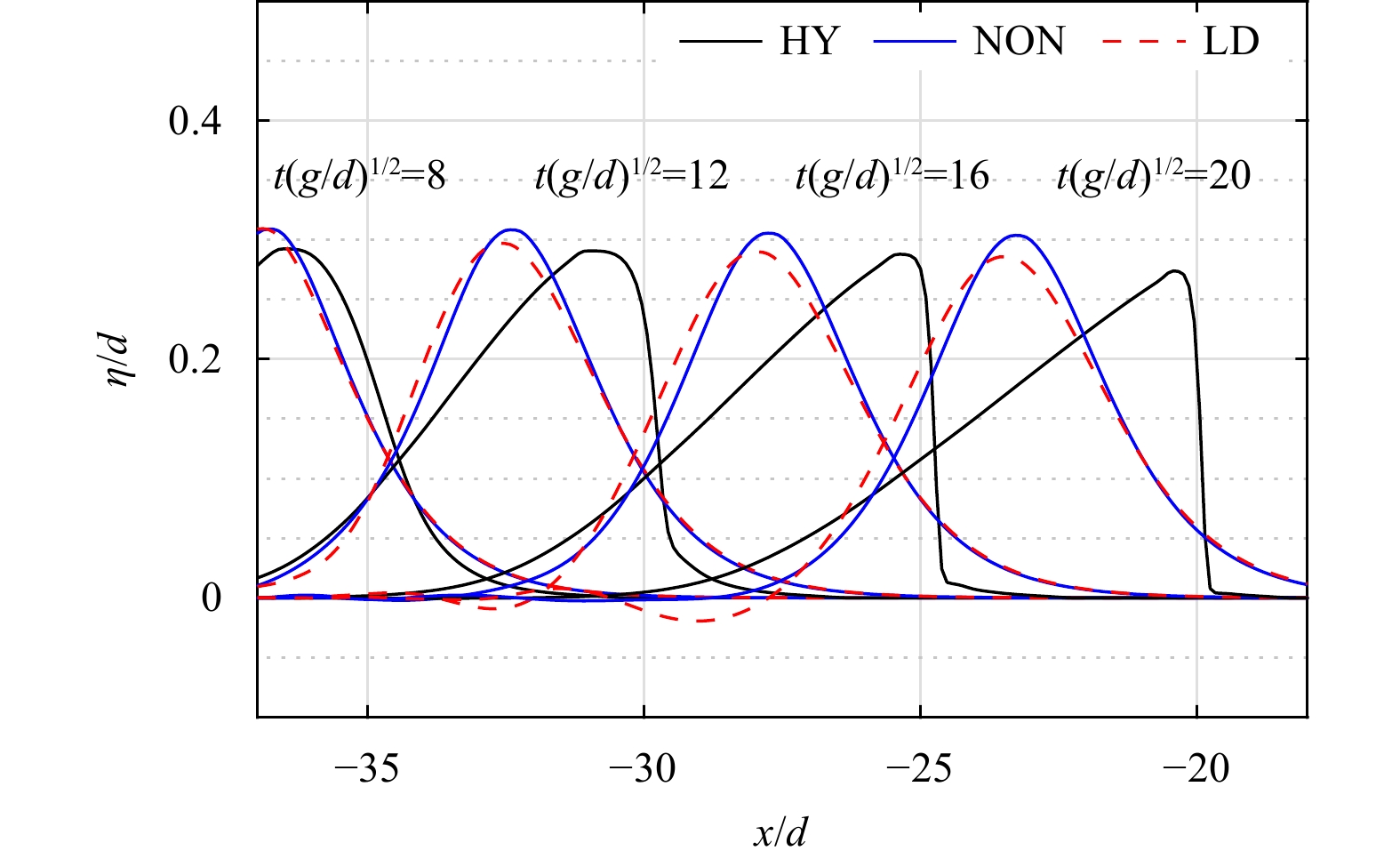
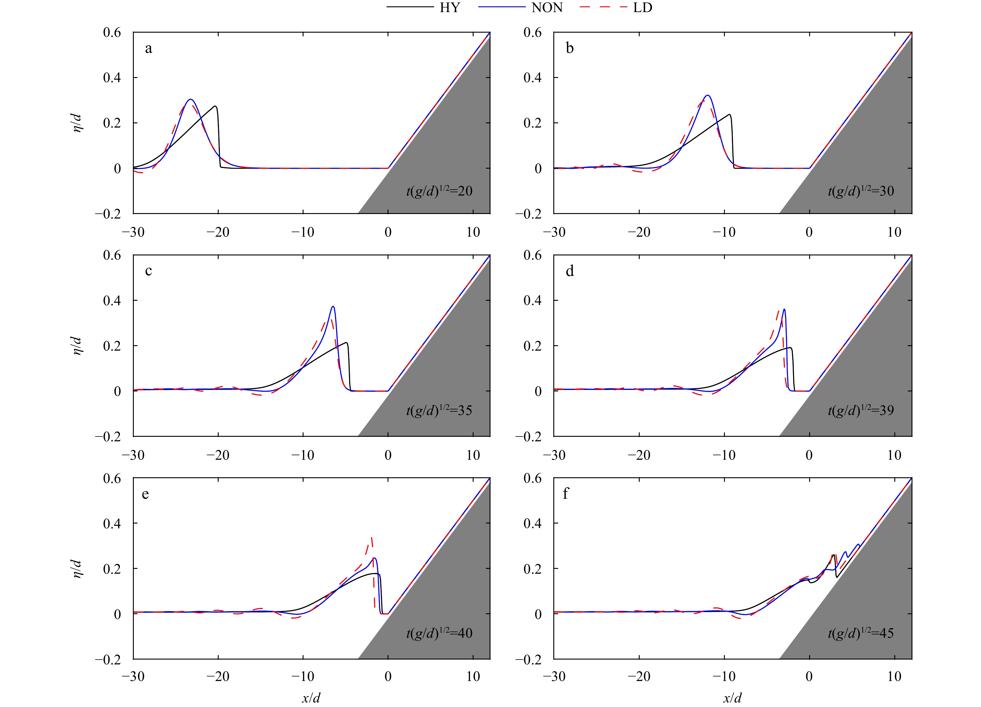
This paper examines the simplification strategy of retaining only the nonhydrostatic effect of local acceleration in a three-dimensional fully nonhydrostatic model regarding the submesoscale wave phenomenon in the ocean. Elaborate scale analysis of the vertical component of the Reynold-averaged Navier–Stokes (RANS) equation was performed, confirming the rationalization of this simplification. Then, the simplification was implemented in a RANS equation-based nonhydrostatic model NHWAVE (nonhydrostatic WAVE) to make a simplified nonhydrostatic model. Numerical examples were taken to test its performance, including surface sinusoidal waves propagating on an idealized East China Sea topography, tidally induced internal lee waves and small-scale solitary waves. The results show that in a considerably wide range of nonlinear strengths, the simplified nonhydrostatic model can obtain similar results as those in the fully nonhydrostatic model, even for smaller-scale solitary waves. Nonlinearity influences the applicability of the simplification. The stronger the nonlinearity is, the worse the simplified model describes the nonhydrostatic phenomenon. In general, the simplified nonhydrostatic model can simulate surface waves better than internal waves. Improvement of computational efficiency in the simplified nonhydrostatic model is reasonable, reducing the central processing unit time duration in the fully nonhydrostatic model by 16.4%–20.6%. The specially designed algorithm based on the simplified nonhydrostatic equation can remarkably reduce the computational time.
This paper examines the simplification strategy of retaining only the nonhydrostatic effect of local acceleration in a three-dimensional fully nonhydrostatic model regarding the submesoscale wave phenomenon in the ocean. Elaborate scale analysis of the vertical component of the Reynold-averaged Navier–Stokes (RANS) equation was performed, confirming the rationalization of this simplification. Then, the simplification was implemented in a RANS equation-based nonhydrostatic model NHWAVE (nonhydrostatic WAVE) to make a simplified nonhydrostatic model. Numerical examples were taken to test its performance, including surface sinusoidal waves propagating on an idealized East China Sea topography, tidally induced internal lee waves and small-scale solitary waves. The results show that in a considerably wide range of nonlinear strengths, the simplified nonhydrostatic model can obtain similar results as those in the fully nonhydrostatic model, even for smaller-scale solitary waves. Nonlinearity influences the applicability of the simplification. The stronger the nonlinearity is, the worse the simplified model describes the nonhydrostatic phenomenon. In general, the simplified nonhydrostatic model can simulate surface waves better than internal waves. Improvement of computational efficiency in the simplified nonhydrostatic model is reasonable, reducing the central processing unit time duration in the fully nonhydrostatic model by 16.4%–20.6%. The specially designed algorithm based on the simplified nonhydrostatic equation can remarkably reduce the computational time.


2023, 42(2): 44-55.
doi: 10.1007/s13131-021-1976-y
Abstract:
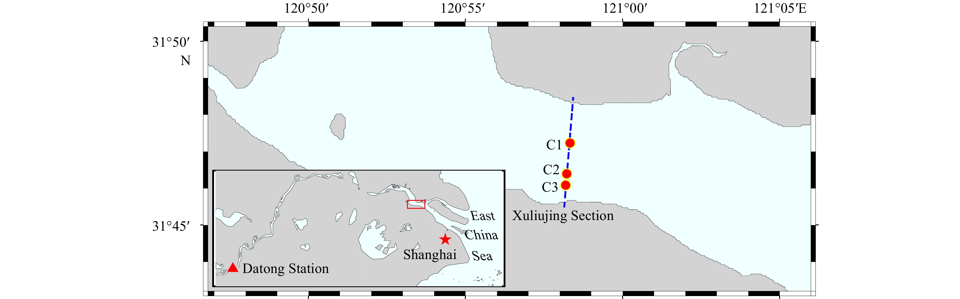
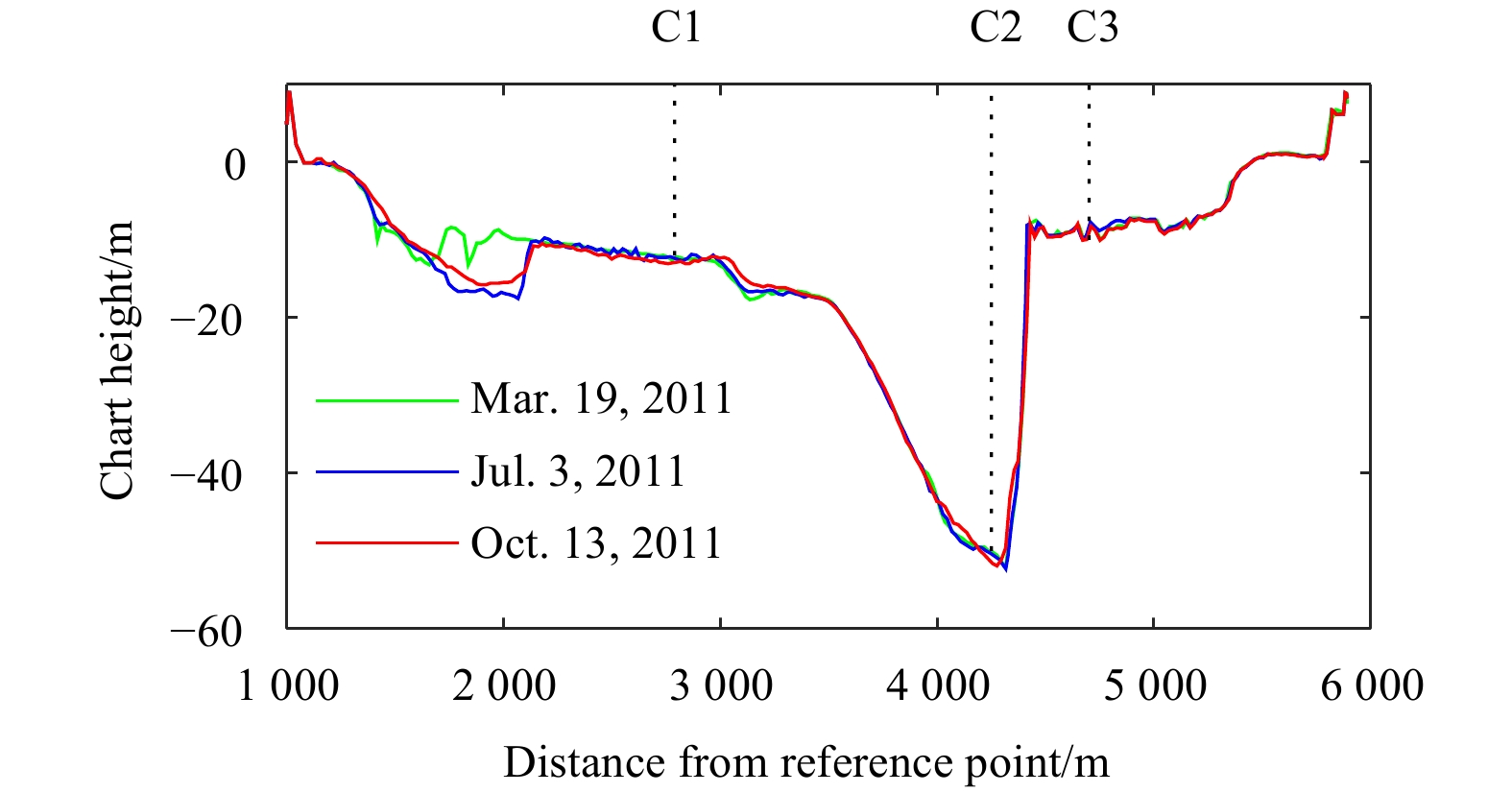
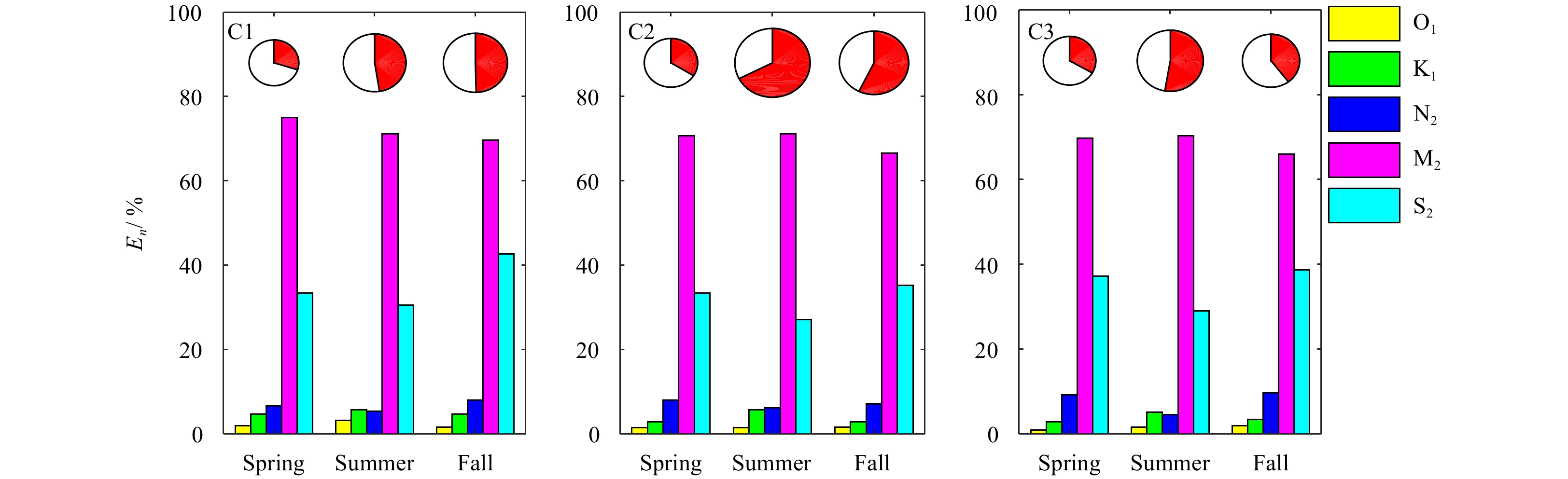
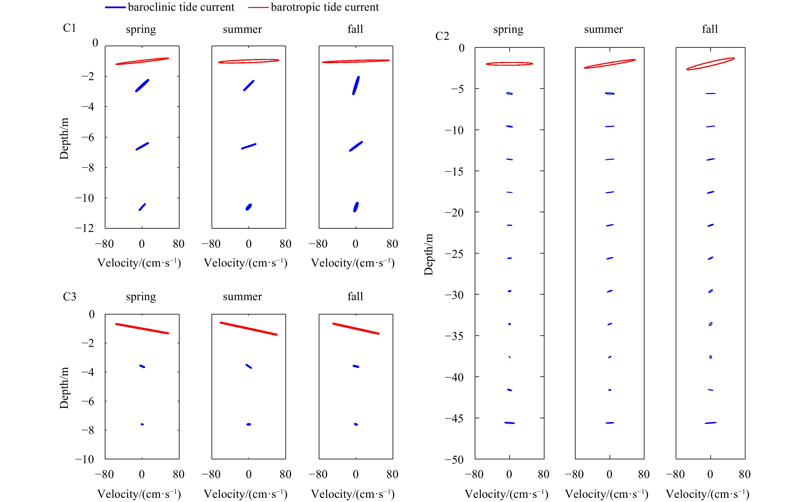
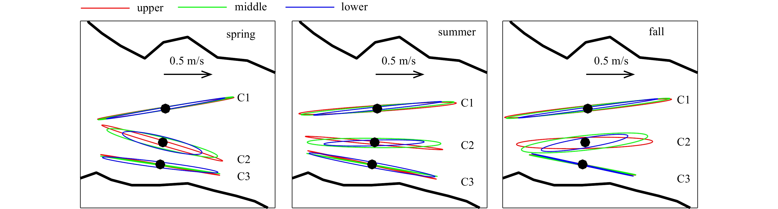
Three long-term fixed acoustic Doppler current profilers were first used for investigating the vertical structure of tidal currents in Xuliujing Section of Changjiang River Estuary. Moreover, three different periods (spring, summer and fall) were also considered for investigating seasonal variations. The semi-diurnal tides were the most energetic, with along-channel speed of up to 80 cm/s for M2 constituent, which dominates at all stations with percent energy up to 65%–75% during seasons. The shape of tidal ellipses of the most energetic semi-diurnal constituent M2 showed obvious polarization of the flow paralleling to the riverbank, with the minor semi-axis being generally less than 20% of the major one. The maximum velocity of mean current is appeared in top layers at all the three stations, and the velocity decreased with the depth. The seasonal variations of direction are also observed, which is probably caused by complex local topography since the erosion and deposition in riverbed. Observed vertical variation of four parameters of M2 ellipses, agreed well with the optimally fit frictional solutions in top and middle layers. However, there was an obvious difference between frictional model and observed data in the lower water column. Discrepancies are probably on account of stratification, which strengthens in summer and fall due to the freshening influence of the Changjiang River Estuary outflow.
Three long-term fixed acoustic Doppler current profilers were first used for investigating the vertical structure of tidal currents in Xuliujing Section of Changjiang River Estuary. Moreover, three different periods (spring, summer and fall) were also considered for investigating seasonal variations. The semi-diurnal tides were the most energetic, with along-channel speed of up to 80 cm/s for M2 constituent, which dominates at all stations with percent energy up to 65%–75% during seasons. The shape of tidal ellipses of the most energetic semi-diurnal constituent M2 showed obvious polarization of the flow paralleling to the riverbank, with the minor semi-axis being generally less than 20% of the major one. The maximum velocity of mean current is appeared in top layers at all the three stations, and the velocity decreased with the depth. The seasonal variations of direction are also observed, which is probably caused by complex local topography since the erosion and deposition in riverbed. Observed vertical variation of four parameters of M2 ellipses, agreed well with the optimally fit frictional solutions in top and middle layers. However, there was an obvious difference between frictional model and observed data in the lower water column. Discrepancies are probably on account of stratification, which strengthens in summer and fall due to the freshening influence of the Changjiang River Estuary outflow.


2023, 42(2): 56-64.
doi: 10.1007/s13131-022-2072-7
Abstract:
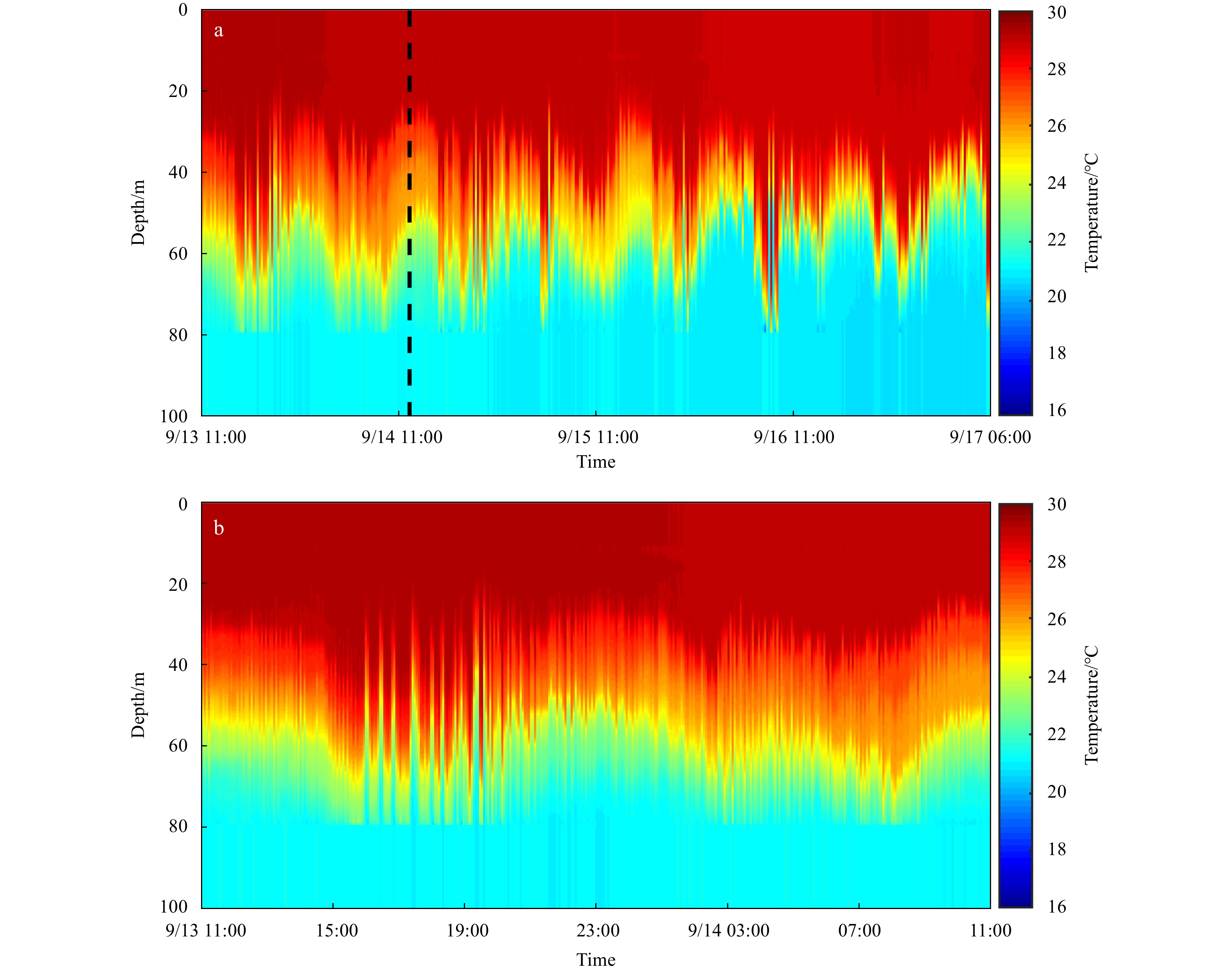
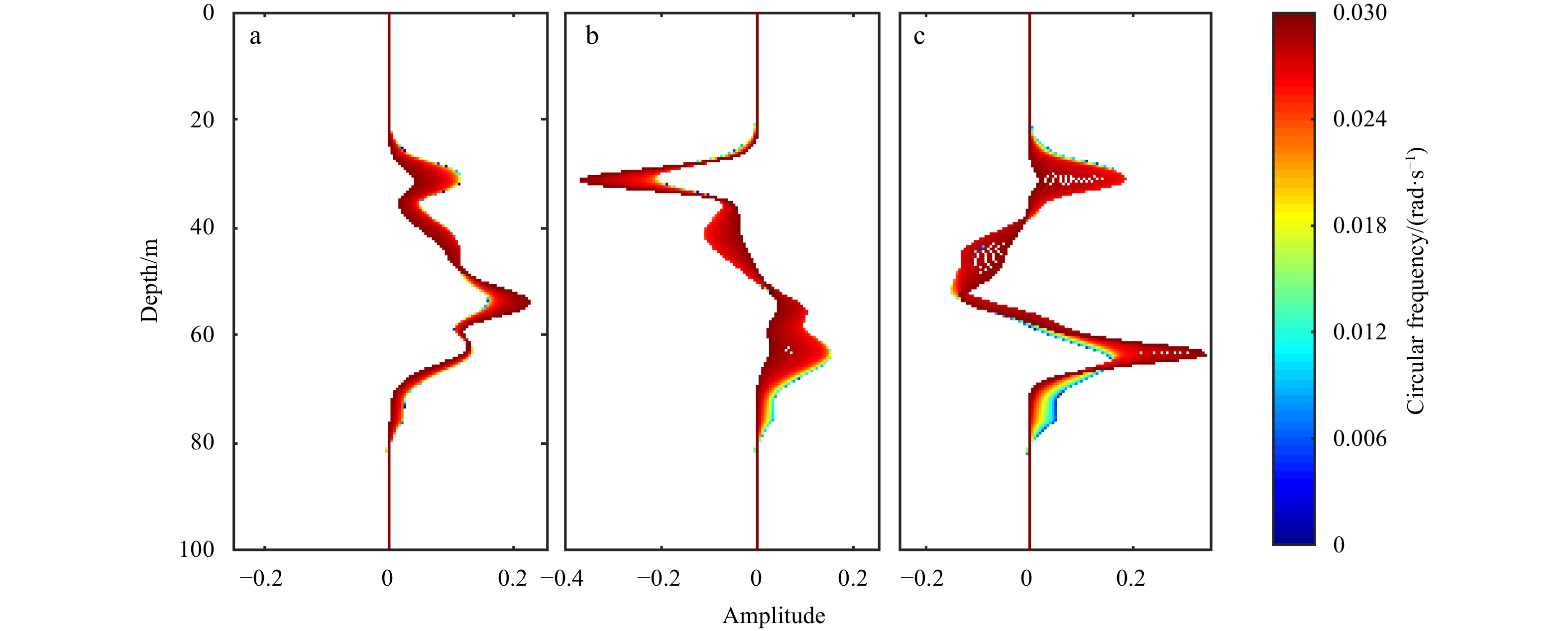
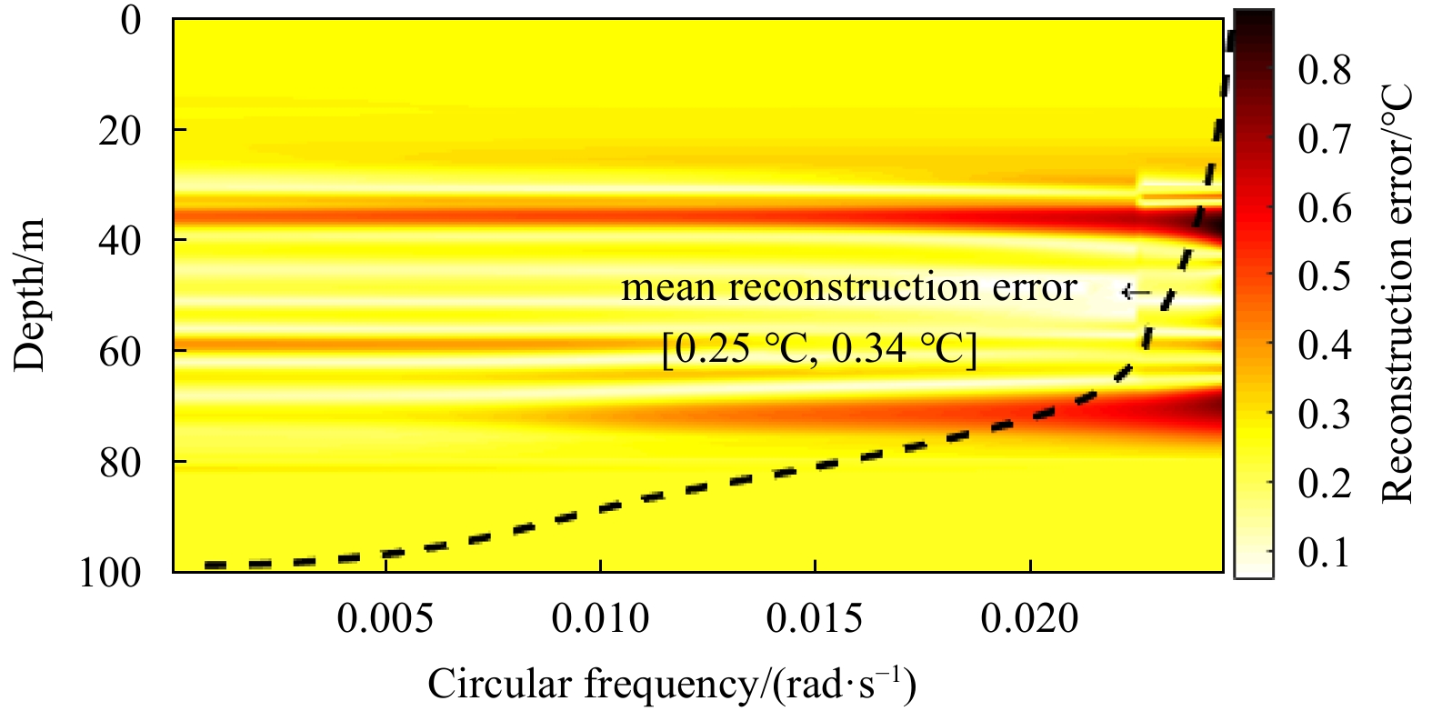
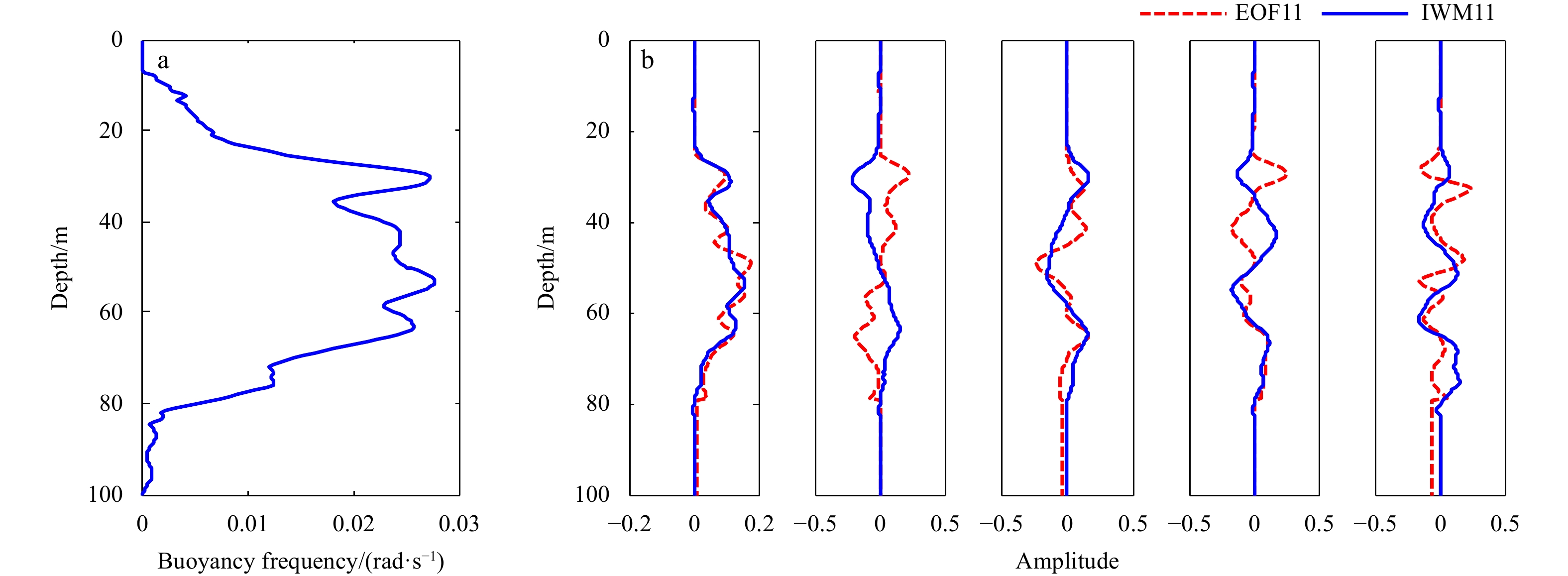
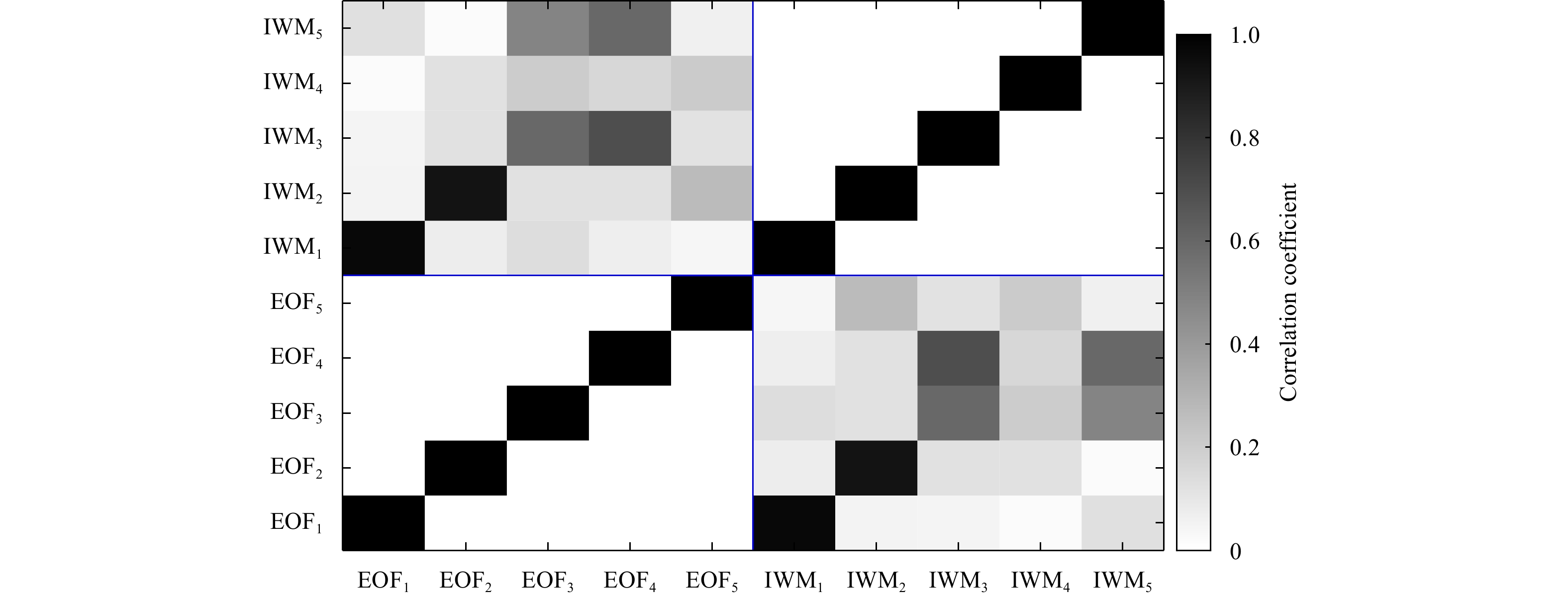
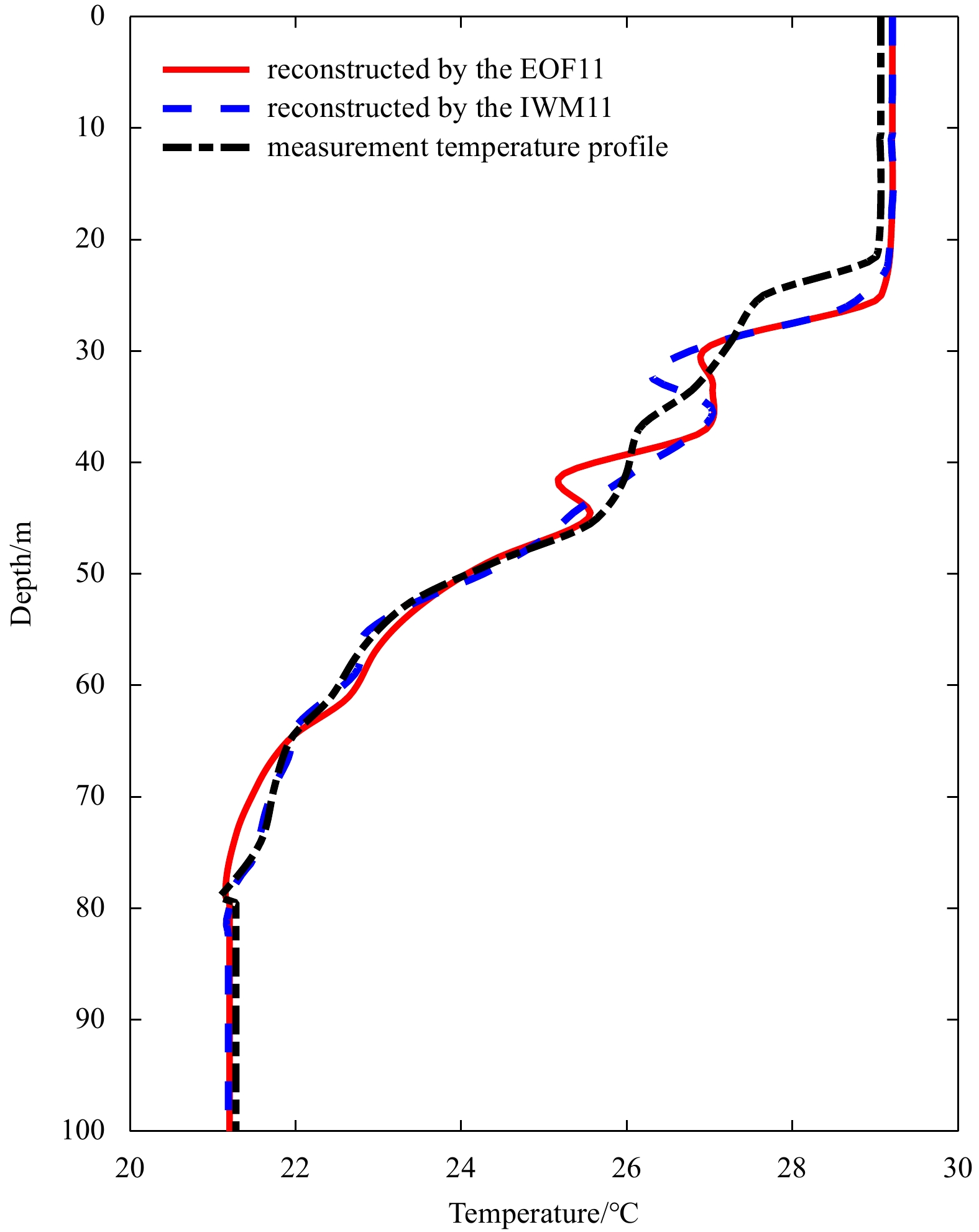
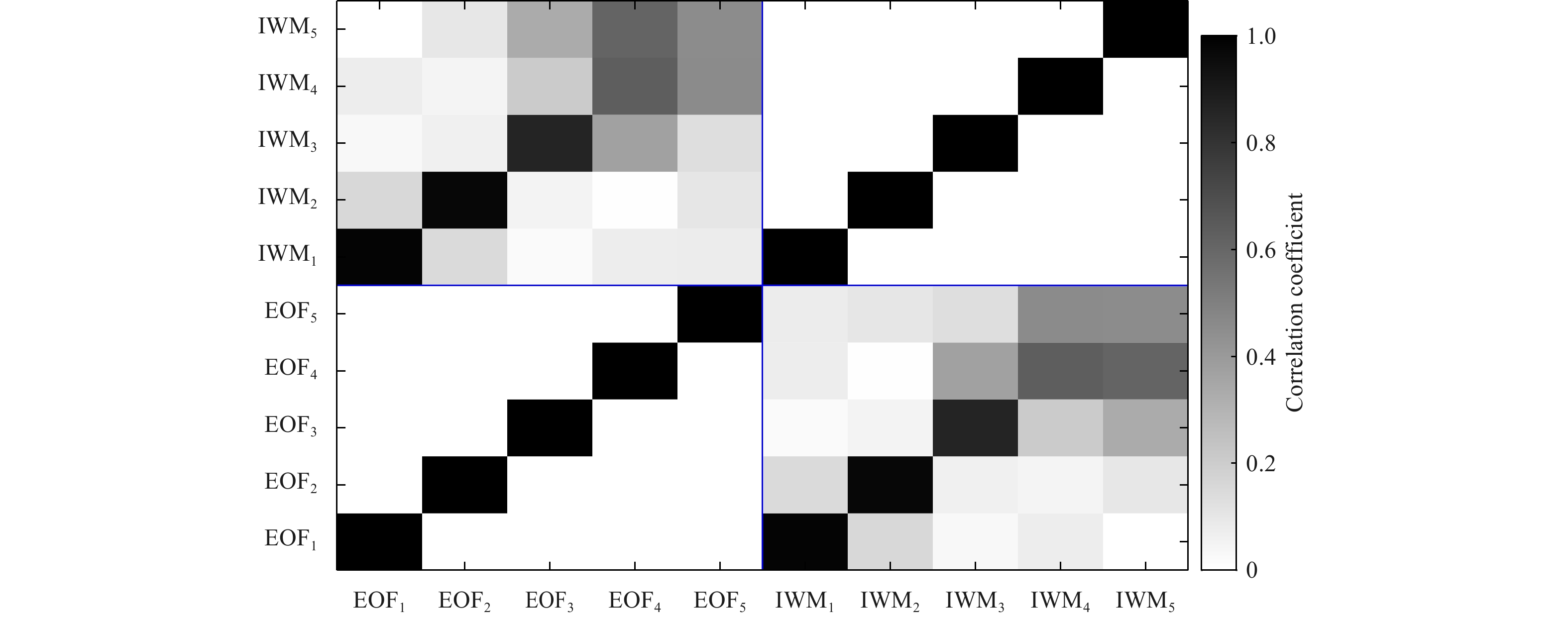
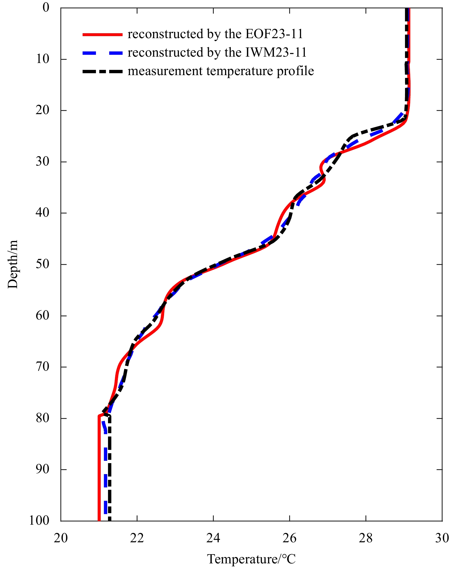
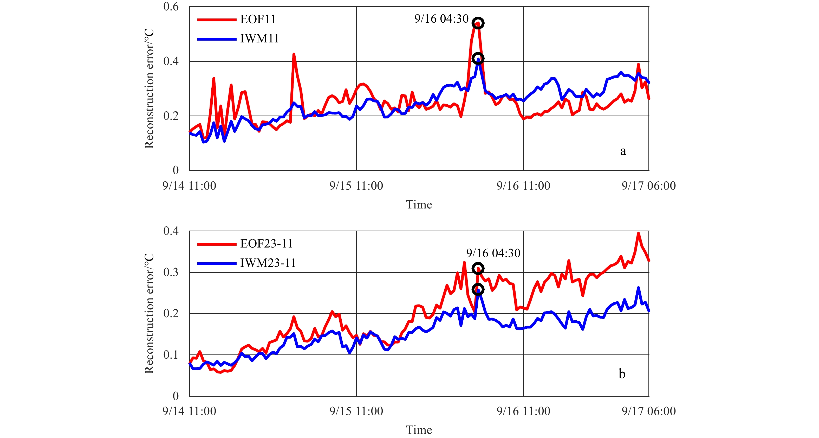
The shallow-water temperature profile is typically parameterized using a few empirical orthogonal function (EOF) coefficients. However, when the experimental area is poorly known or highly variable, the adaptability of the EOFs will be significantly reduced. In this study, a new set of basis functions, generated by combining the internal-wave eigenmodes with the average temperature gradient, is developed for characterizing the temperature perturbations. Temperature profiles recorded by a thermistor chain in the South China Sea in 2015 are processed and analyzed. Compared to the EOFs, the new set of basis functions has higher reconstruction accuracy and adaptability; it is also more stable in ocean regions that have internal waves.
The shallow-water temperature profile is typically parameterized using a few empirical orthogonal function (EOF) coefficients. However, when the experimental area is poorly known or highly variable, the adaptability of the EOFs will be significantly reduced. In this study, a new set of basis functions, generated by combining the internal-wave eigenmodes with the average temperature gradient, is developed for characterizing the temperature perturbations. Temperature profiles recorded by a thermistor chain in the South China Sea in 2015 are processed and analyzed. Compared to the EOFs, the new set of basis functions has higher reconstruction accuracy and adaptability; it is also more stable in ocean regions that have internal waves.


2023, 42(2): 65-73.
doi: 10.1007/s13131-022-2025-1
Abstract:
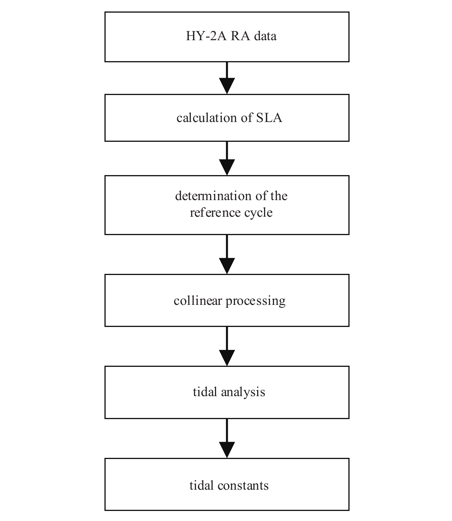
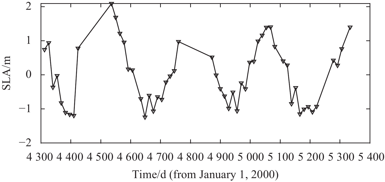
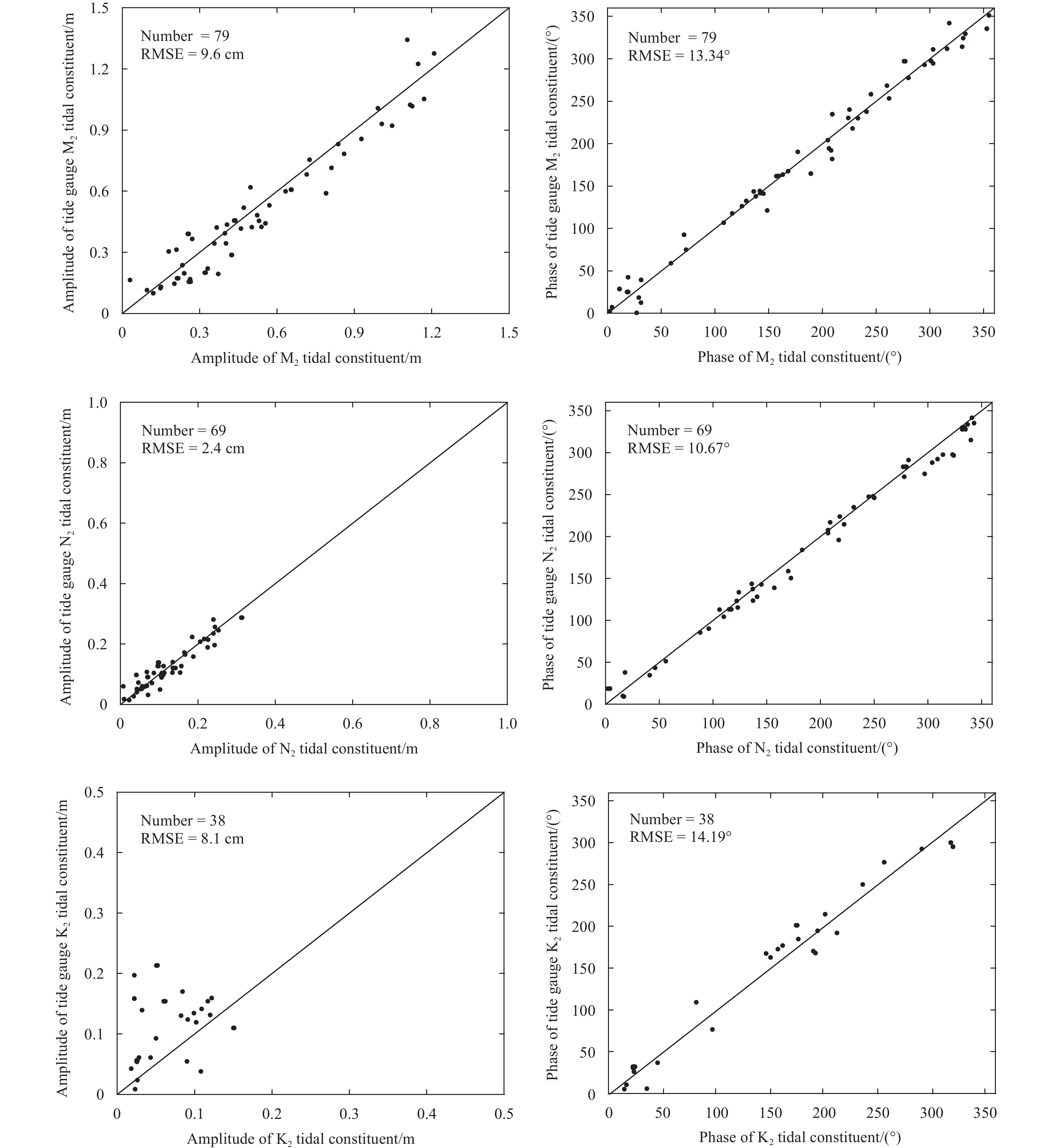
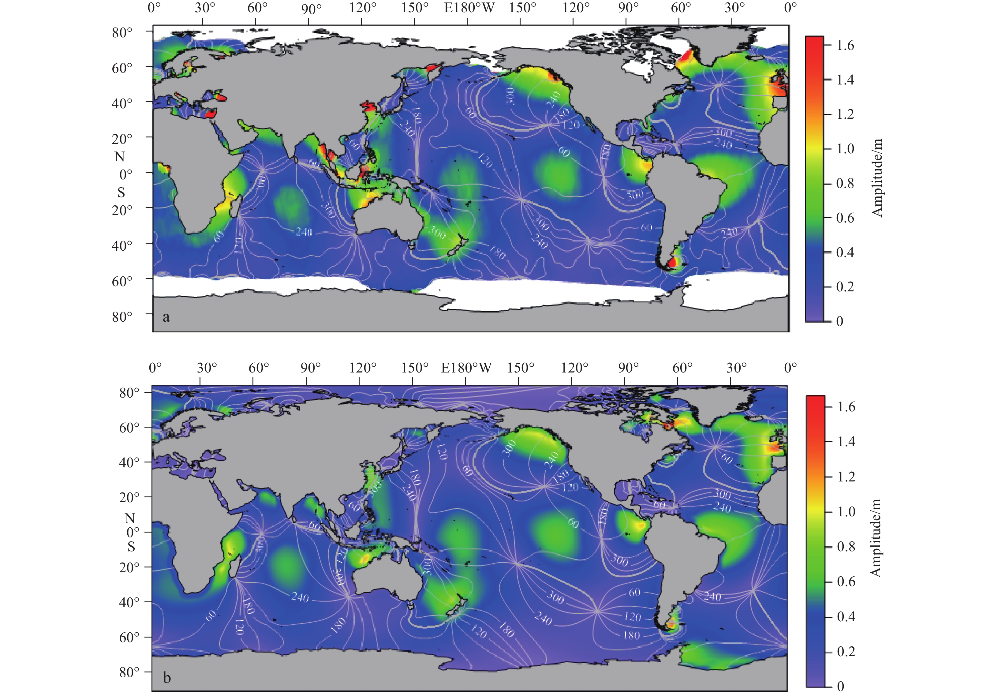
The HY-2A satellite, which is equipped with a radar altimeter and was launched on August 16, 2011, is the first Chinese marine dynamic environmental monitoring satellite. Extracting ocean tides is one of the important applications of the radar altimeter data. The radar altimeter data of the HY-2A satellite from November 1, 2011 to August 16, 2014 are used herein to extract global ocean tides. The constants representing the tidal constituents are extracted by HY-2A RA data with harmonic analysis based on the least squares method. Considering tide aliasing issues, the analysis of the alias periods and alias synodic periods of different tidal constituents shows that only the tidal constituents M2, N2, and K2 are retrieved precisely by the HY-2A RA data. The derived tidal constants of the tidal constituents M2, N2 and K2 are compared to those of tidal gauge data and the TPXO tide model results. The comparison between the derived results and the tidal gauge data shows that the RMSEs of the tidal amplitude and phase lag are 9.6 cm and 13.34°, 2.4 cm and 10.47°, and 8.1 cm and 14.19° for tidal constituents M2, N2, and K2, respectively. The comparisons of the semidiurnal tides with the TPXO model results show that tidal constituents have good consistency with the TPXO model results. These findings confirm the good performance of HY-2A RA for retrieving semidiurnal tides in the global ocean.
The HY-2A satellite, which is equipped with a radar altimeter and was launched on August 16, 2011, is the first Chinese marine dynamic environmental monitoring satellite. Extracting ocean tides is one of the important applications of the radar altimeter data. The radar altimeter data of the HY-2A satellite from November 1, 2011 to August 16, 2014 are used herein to extract global ocean tides. The constants representing the tidal constituents are extracted by HY-2A RA data with harmonic analysis based on the least squares method. Considering tide aliasing issues, the analysis of the alias periods and alias synodic periods of different tidal constituents shows that only the tidal constituents M2, N2, and K2 are retrieved precisely by the HY-2A RA data. The derived tidal constants of the tidal constituents M2, N2 and K2 are compared to those of tidal gauge data and the TPXO tide model results. The comparison between the derived results and the tidal gauge data shows that the RMSEs of the tidal amplitude and phase lag are 9.6 cm and 13.34°, 2.4 cm and 10.47°, and 8.1 cm and 14.19° for tidal constituents M2, N2, and K2, respectively. The comparisons of the semidiurnal tides with the TPXO model results show that tidal constituents have good consistency with the TPXO model results. These findings confirm the good performance of HY-2A RA for retrieving semidiurnal tides in the global ocean.

2023, 42(2): 74-82.
doi: 10.1007/s13131-022-2030-4
Abstract:
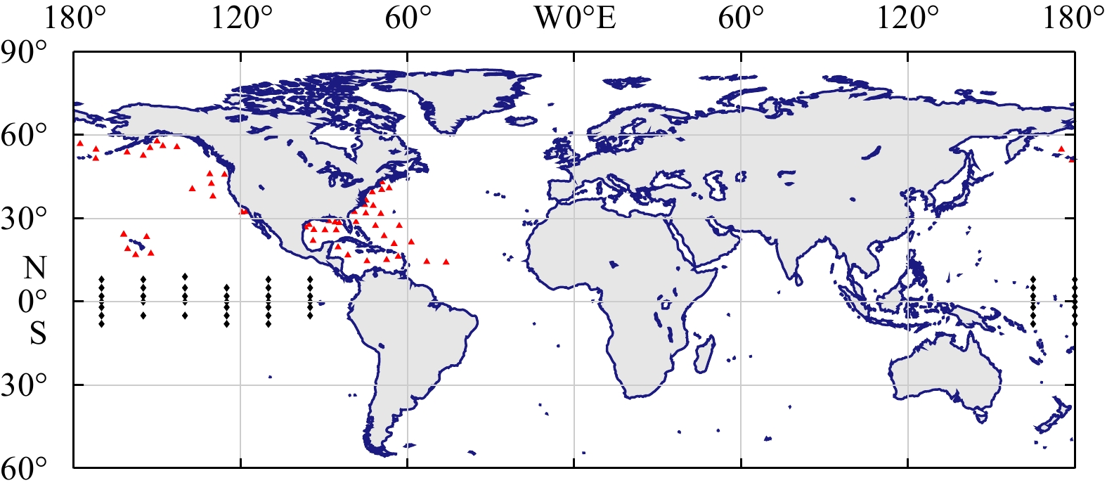
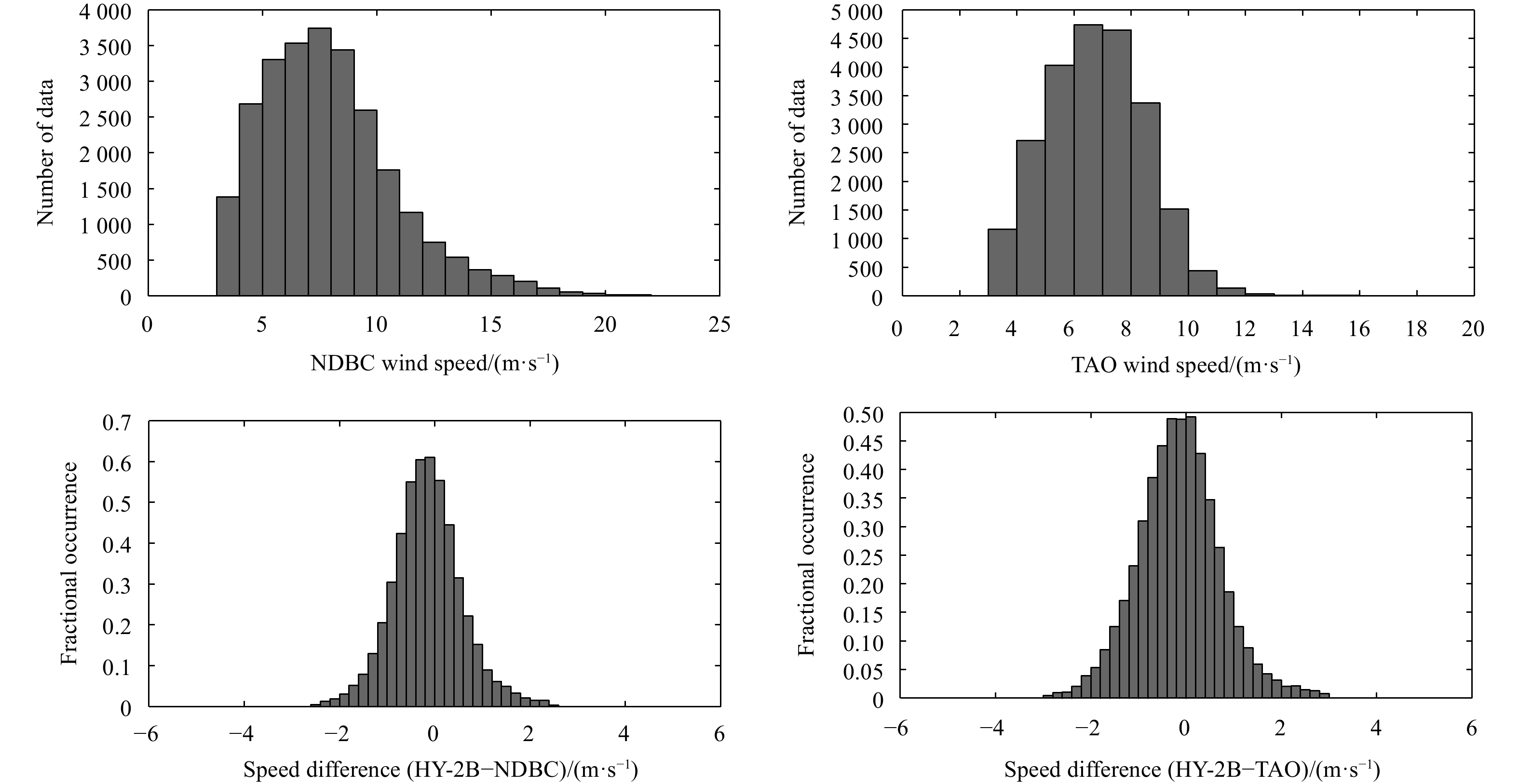
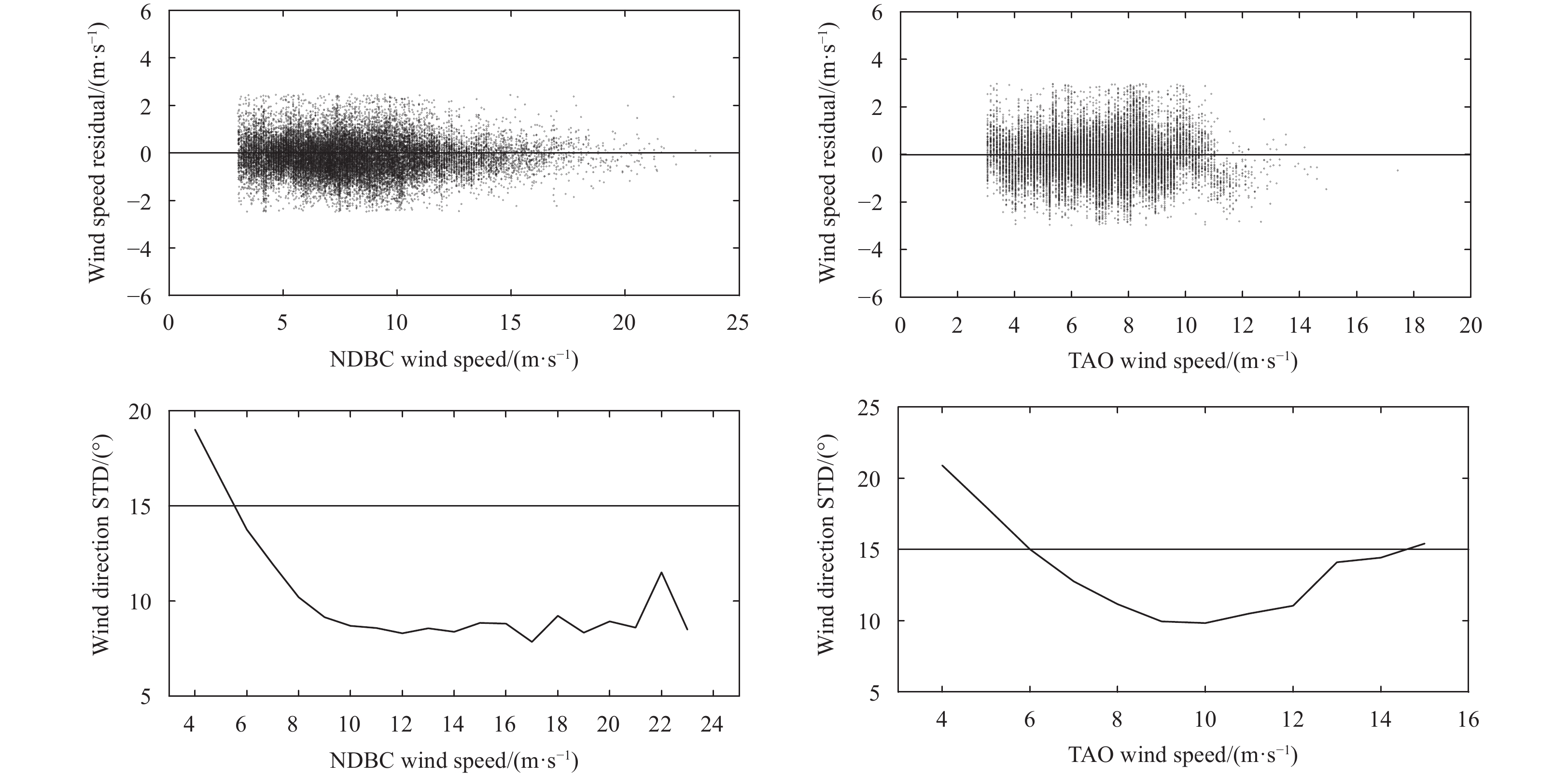
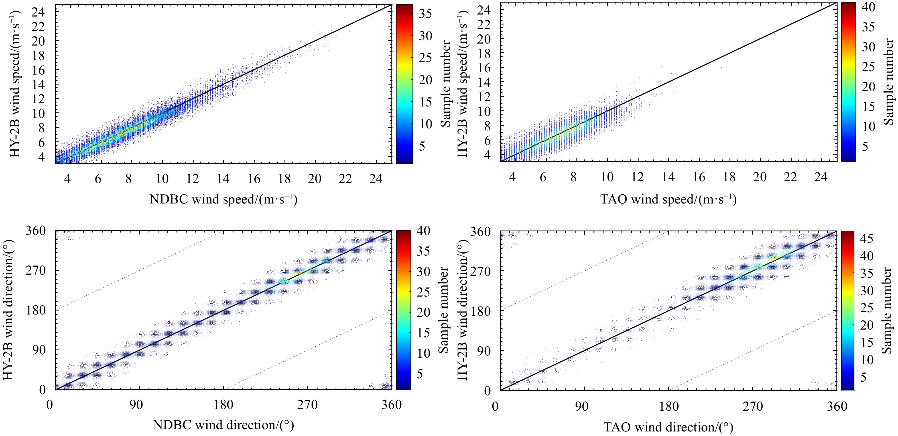
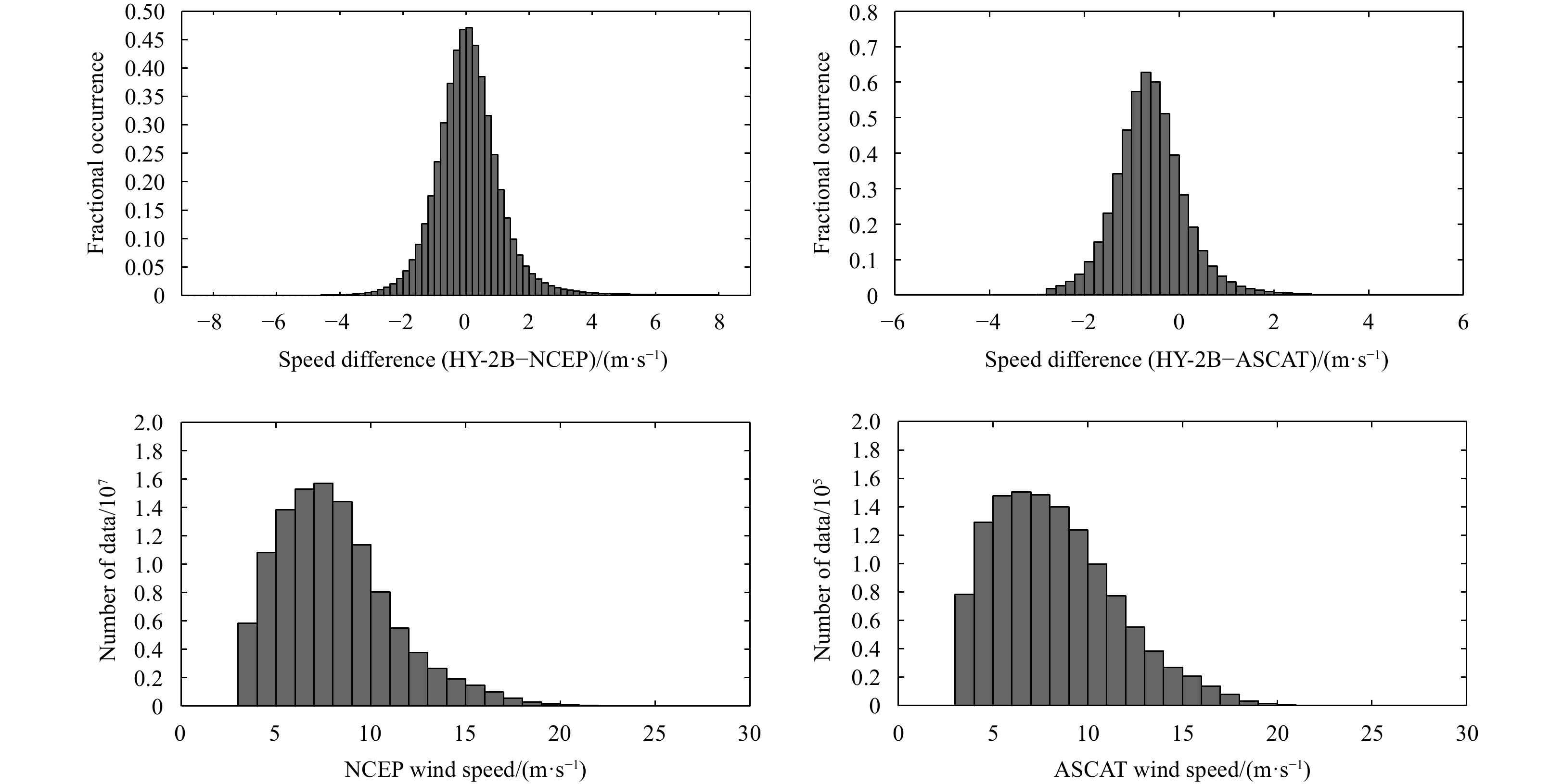
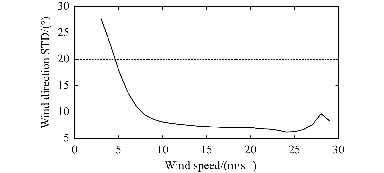
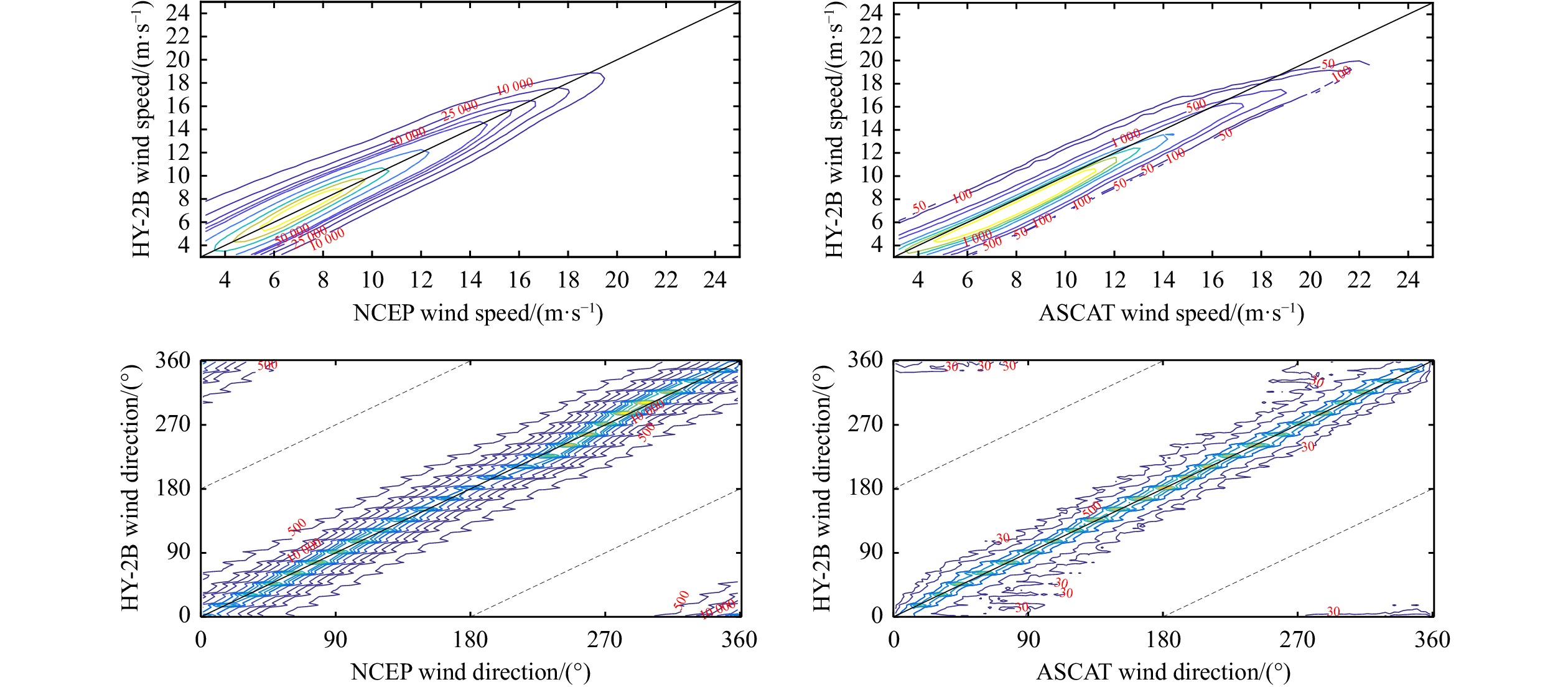
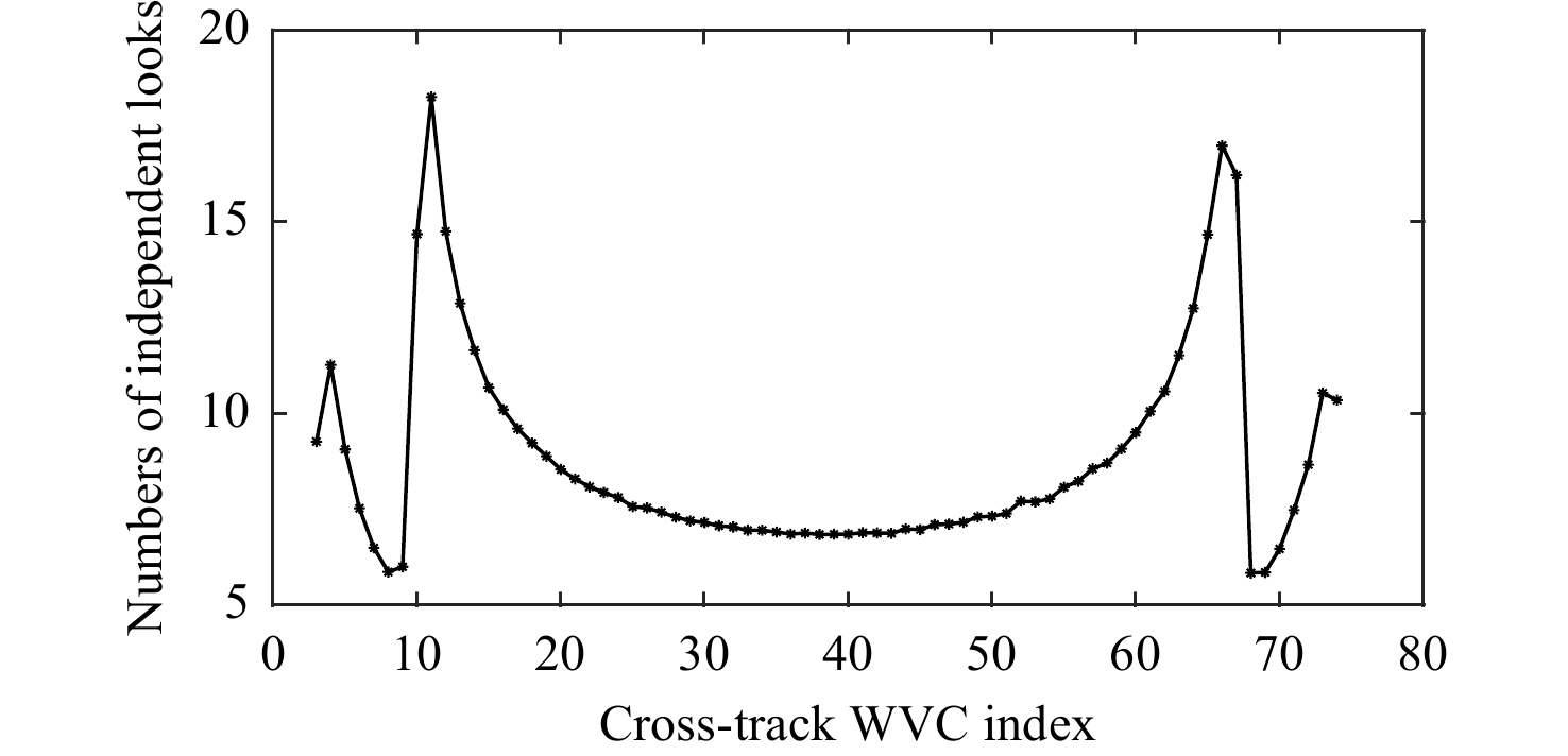
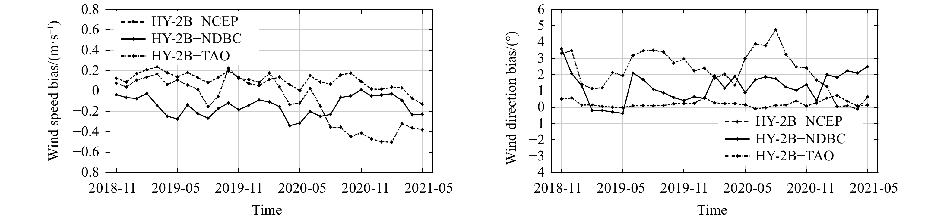
The Chinese marine dynamic environment satellite HY-2B was launched in October 2018 and carries a Ku-band scatterometer. This paper focuses on the accuracies of HY-2B scatterometer wind data during the period from November 2018 to May 2021. The HY-2B wind data are validated against global moored buoys operated by the U.S. National Data Buoy Center and Tropical Atmosphere Ocean, numerical model data by the National Centers for Environmental Prediction, and the Advanced Scatterometer data issued by the Remote Sensing System. The results showed that the wind speeds and directions observed by the HY-2B scatterometer agree well with these buoy wind measurements. The root-mean-squared errors (RMSEs) of the HY-2B wind speed and direction are 0.74 m/s and 11.74°, respectively. For low wind speeds (less than 5 m/s), the standard deviation of the HY-2B-derived wind direction is higher than 20°, which implies that the HY-2B wind direction for low wind speeds is less accurate than that for moderate to high wind speed ranges. The RMSE of the HY-2B wind speed is slightly larger in high latitude oceans (60°–90°S and 60°–90°N) than in low latitude regions. Furthermore, the dependence of the residuals on the cross-track location of wind vector cells and the stability of the HY-2B scatterometer wind products are discussed. The wind stability assessment results indicate that a clear yearly oscillation is observed for the HY-2B wind speed bias which is due to seasonal weather variations. In general, the accuracy of HY-2B winds meets the operational precision requirement and is consistent with other wind data.
The Chinese marine dynamic environment satellite HY-2B was launched in October 2018 and carries a Ku-band scatterometer. This paper focuses on the accuracies of HY-2B scatterometer wind data during the period from November 2018 to May 2021. The HY-2B wind data are validated against global moored buoys operated by the U.S. National Data Buoy Center and Tropical Atmosphere Ocean, numerical model data by the National Centers for Environmental Prediction, and the Advanced Scatterometer data issued by the Remote Sensing System. The results showed that the wind speeds and directions observed by the HY-2B scatterometer agree well with these buoy wind measurements. The root-mean-squared errors (RMSEs) of the HY-2B wind speed and direction are 0.74 m/s and 11.74°, respectively. For low wind speeds (less than 5 m/s), the standard deviation of the HY-2B-derived wind direction is higher than 20°, which implies that the HY-2B wind direction for low wind speeds is less accurate than that for moderate to high wind speed ranges. The RMSE of the HY-2B wind speed is slightly larger in high latitude oceans (60°–90°S and 60°–90°N) than in low latitude regions. Furthermore, the dependence of the residuals on the cross-track location of wind vector cells and the stability of the HY-2B scatterometer wind products are discussed. The wind stability assessment results indicate that a clear yearly oscillation is observed for the HY-2B wind speed bias which is due to seasonal weather variations. In general, the accuracy of HY-2B winds meets the operational precision requirement and is consistent with other wind data.


2023, 42(2): 83-93.
doi: 10.1007/s13131-022-2021-5
Abstract:
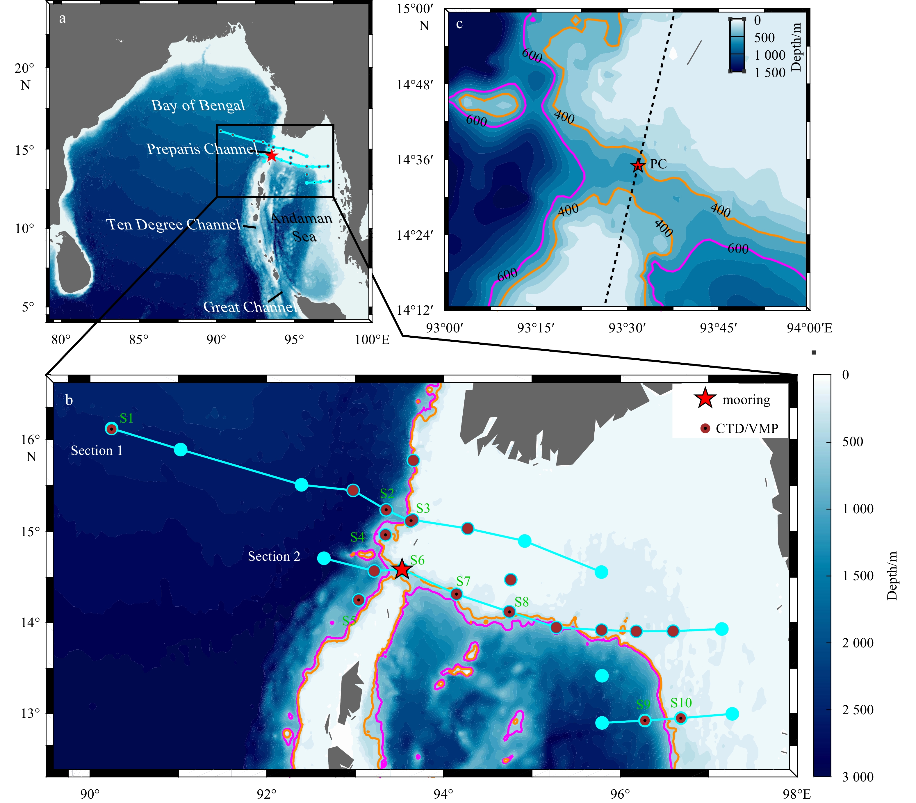
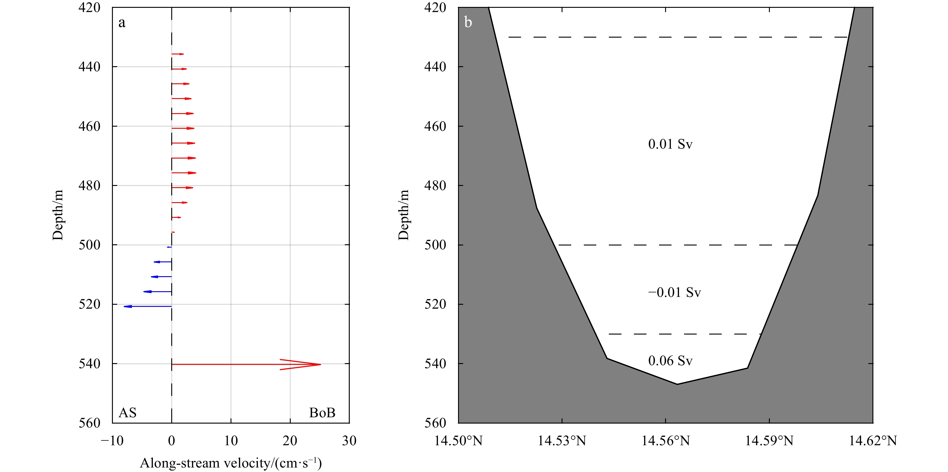
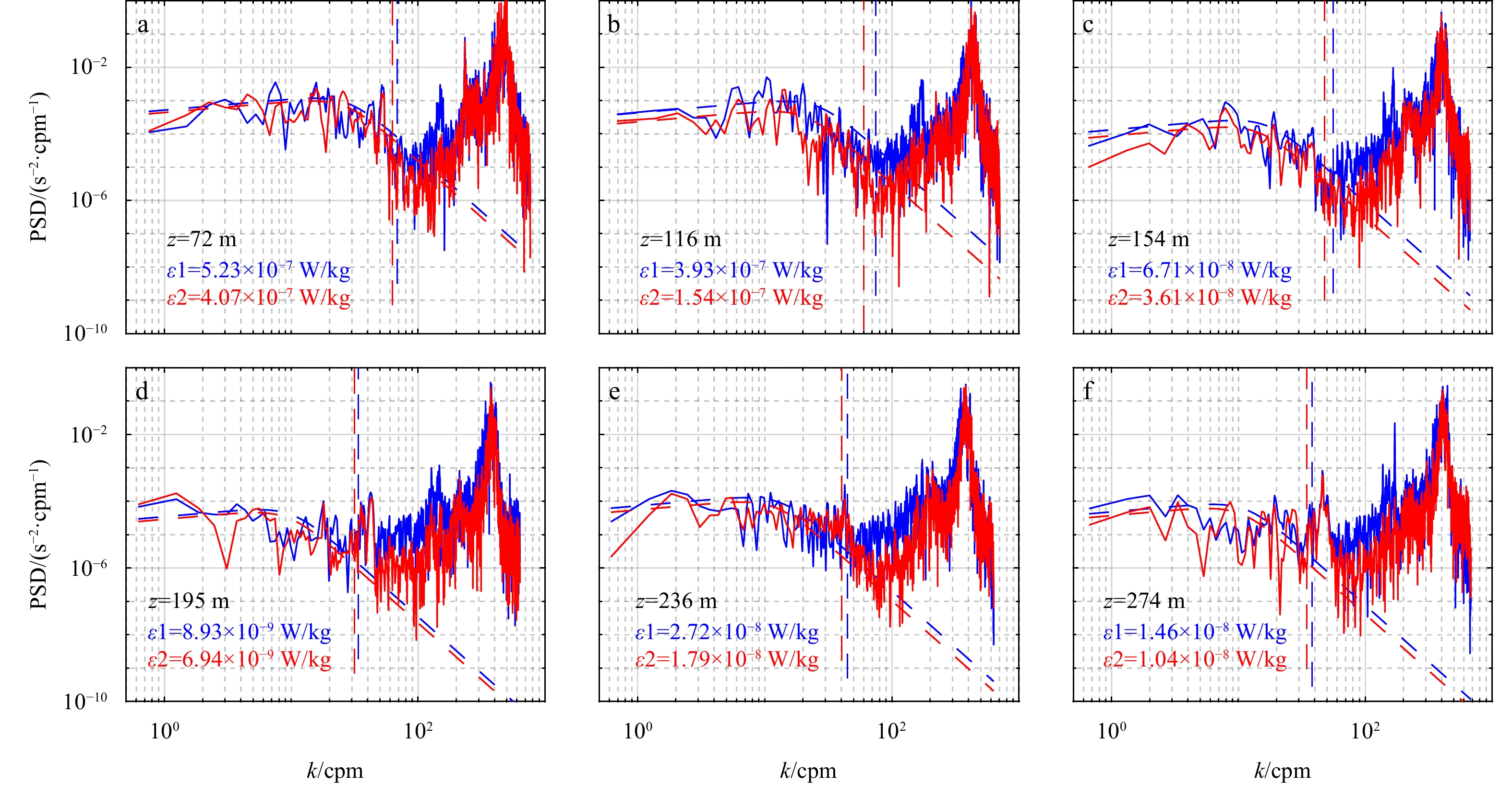
Preparis Channel is the very important exchange path of energy and materials between the northern Bay of Bengal and Andaman Sea (AS). A set of hydrographic measurements, a microstructure profiler, and a deep mooring were used to determine the characteristics of water masses, turbulent mixing, and flows in the Preparis Channel. The unprecedented short-term mooring data reveal that a deep current in the deep narrow passage (below 400 m) of the Preparis Channel flows toward the Bay of Bengal (BoB) with a mean along-stream velocity of 25.26 cm/s at depth of 540 m; above the deep current, there are a relatively weak current flows toward the AS with a mean along-stream velocity of 15.46 cm/s between 500 m and 520 m, and another weak current flows toward the BoB between 430 m and 500 m. Thus, a sandwiched vertical structure of deep currents (below 400 m) is present in the Preparis Channel. The volume transport below 400 m is 0.06 Sv (1 Sv = 106 m3/s) from the AS to the BoB. In the upper layer (shallower than 300 m), the sea water of the AS is relatively warmer and fresher than that in the BoB, indicating a strong exchange through the channel. Microstructure profiler observations reveal that the turbulent diffusivity in the upper layer of the Preparis Channel reaches O(10−4 m2/s), one order larger than that in the interior of the BoB and over the continental slope of the northern AS. We speculate that energetic high-mode internal tides in the Preparis Channel contribute to elevated turbulent mixing. In addition, a local “hotspot” of turbidity is identified at the deep mooring site, at depth of about 100 m, which corresponds to the location of elevated turbulent mixing in the Preparis Channel.
Preparis Channel is the very important exchange path of energy and materials between the northern Bay of Bengal and Andaman Sea (AS). A set of hydrographic measurements, a microstructure profiler, and a deep mooring were used to determine the characteristics of water masses, turbulent mixing, and flows in the Preparis Channel. The unprecedented short-term mooring data reveal that a deep current in the deep narrow passage (below 400 m) of the Preparis Channel flows toward the Bay of Bengal (BoB) with a mean along-stream velocity of 25.26 cm/s at depth of 540 m; above the deep current, there are a relatively weak current flows toward the AS with a mean along-stream velocity of 15.46 cm/s between 500 m and 520 m, and another weak current flows toward the BoB between 430 m and 500 m. Thus, a sandwiched vertical structure of deep currents (below 400 m) is present in the Preparis Channel. The volume transport below 400 m is 0.06 Sv (1 Sv = 106 m3/s) from the AS to the BoB. In the upper layer (shallower than 300 m), the sea water of the AS is relatively warmer and fresher than that in the BoB, indicating a strong exchange through the channel. Microstructure profiler observations reveal that the turbulent diffusivity in the upper layer of the Preparis Channel reaches O(10−4 m2/s), one order larger than that in the interior of the BoB and over the continental slope of the northern AS. We speculate that energetic high-mode internal tides in the Preparis Channel contribute to elevated turbulent mixing. In addition, a local “hotspot” of turbidity is identified at the deep mooring site, at depth of about 100 m, which corresponds to the location of elevated turbulent mixing in the Preparis Channel.


2023, 42(2): 94-103.
doi: 10.1007/s13131-022-2029-x
Abstract:
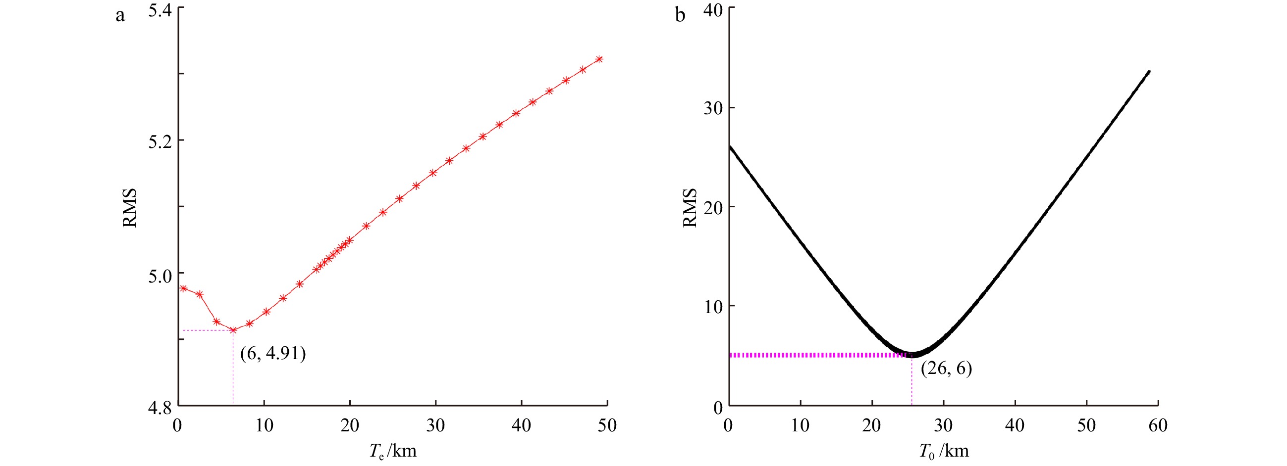
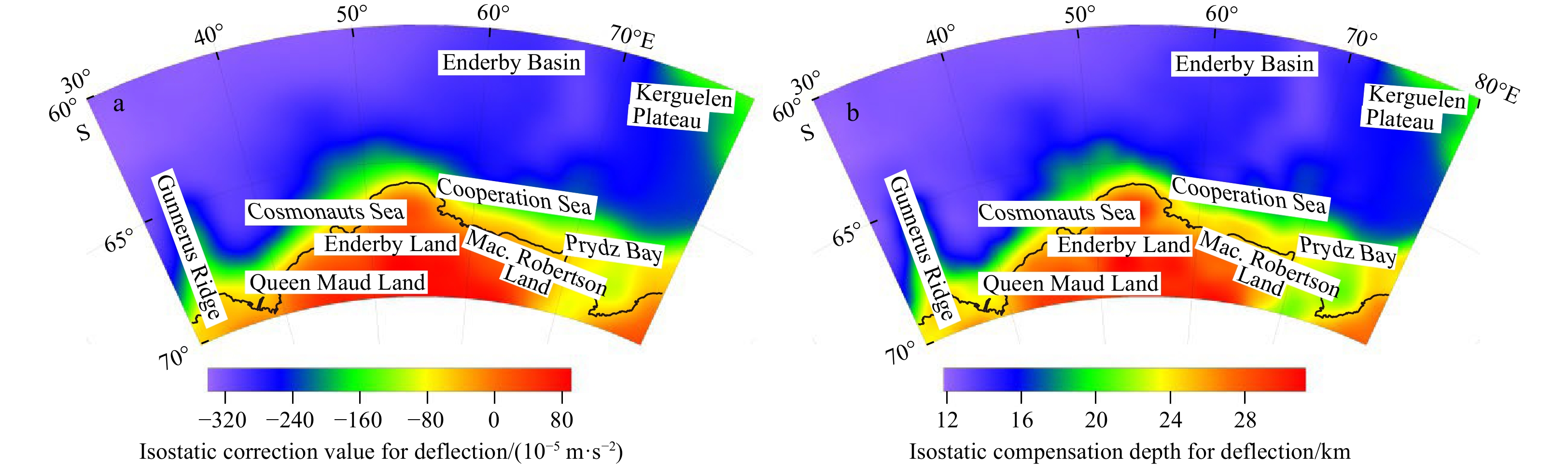
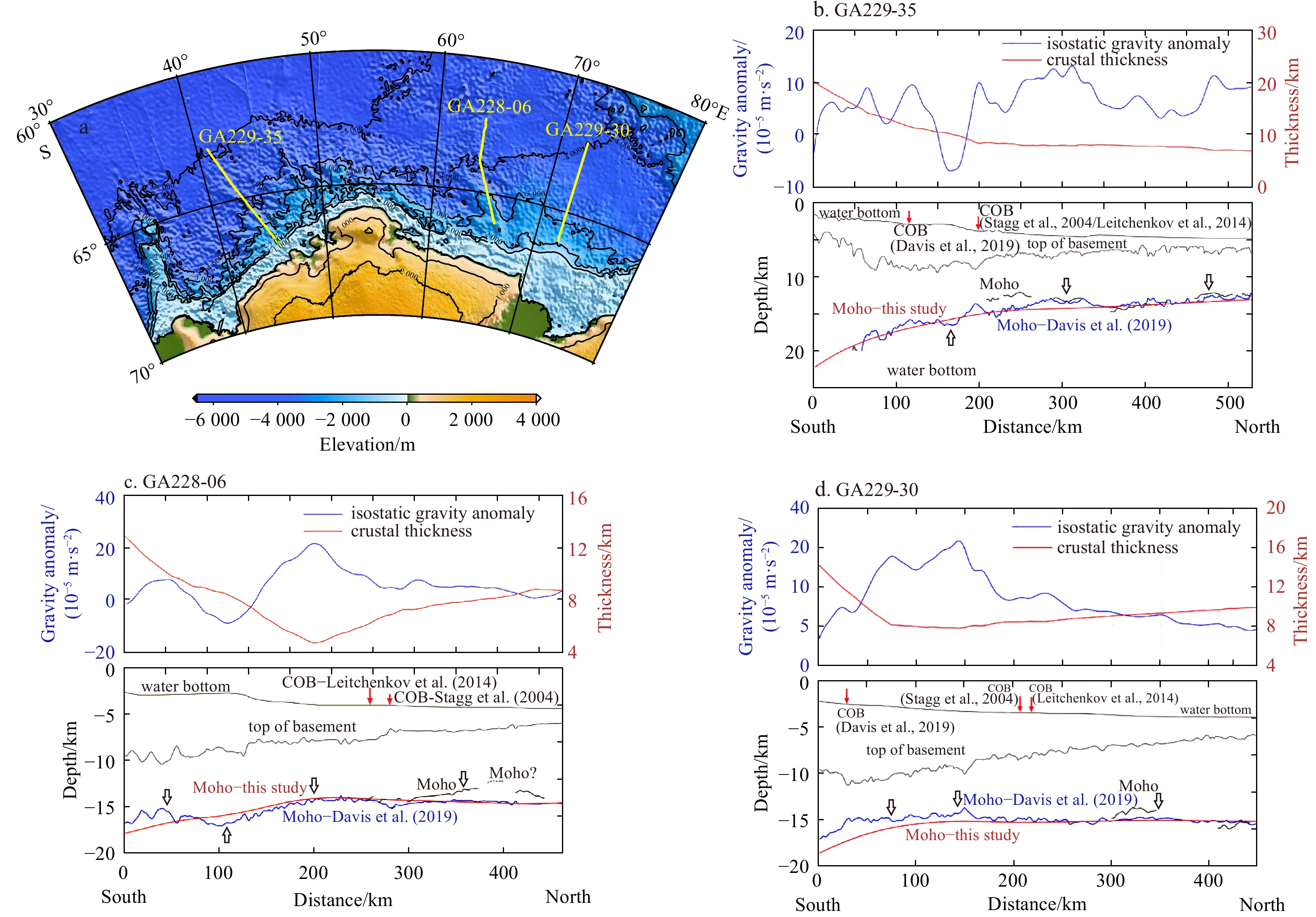
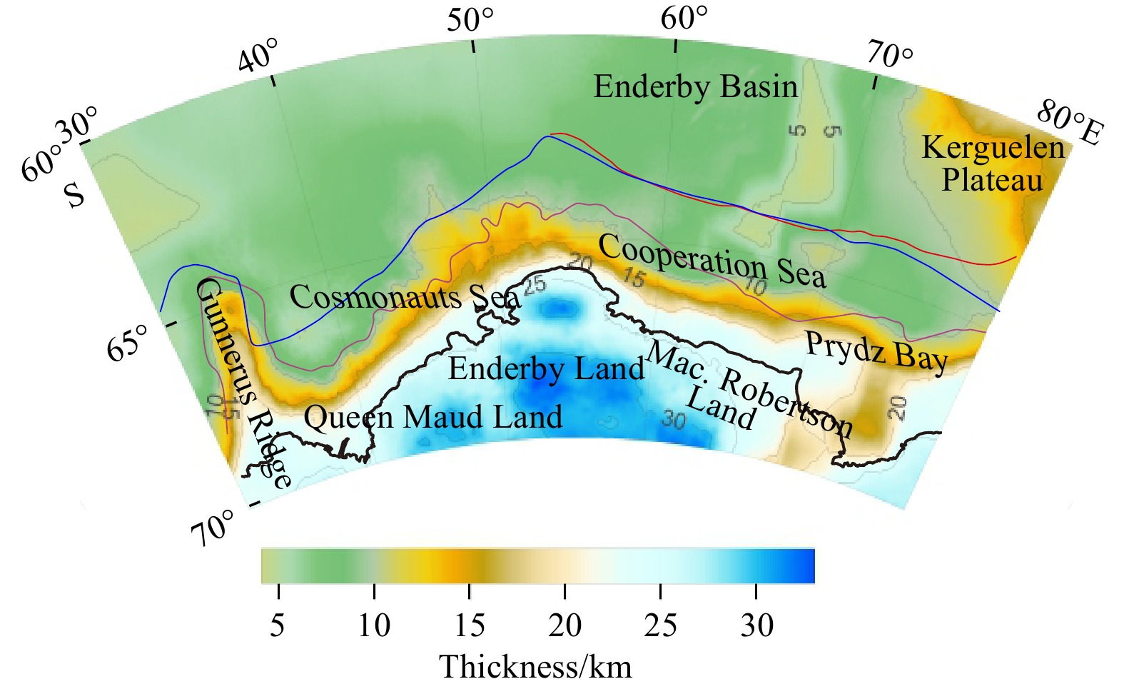
Enderby Land in East Antarctica and its adjacent areas, which are closely related to the Indian Plate in their geological evolution, have become one of the key zones for studies on how the Antarctic continent evolves. Based on the isostasy and flexure theories of the lithosphere and using the CRUST1.0 model as the depth constraint, this paper uses the gravity field model EIGEN-6C4 and topographic data to calculate the isostatic gravity anomalies of Enderby Land and its adjacent areas. Then, the crustal thickness of the study area is calculated, and three comprehensive geophysical interpretation profiles that vertically span the study area are plotted. The results show that the flexural isostatic gravity anomalies in Enderby Land and its adjacent areas are closely related to the regional tectonic setting, and the anomalies in different regions differ substantially, ranging from −50×10−5 m/s2 to 85×10−5 m/s2. A zone of high isostatic gravity anomalies (30×10−5–80×10−5 m/s2) is distributed outside the Cooperation Sea and Queen Maud Land, which may be plate remnants generated by early rifting. Except for the Kerguelen Plateau, which was formed by a hotspot and has a crustal thickness of 15 km, the thickness of the oceanic crust in other parts of the study area changes slightly by approximately 4–9 km, with the thinnest part being in Enderby Basin. The thickness of the inland crust along the coastline increases with the elevation, with the maximum thickness reaching 34 km. The isostatic gravity anomalies corresponding to the zone of high magnetic anomalies along the continental margin of Queen Maud Land are negative and small, with an isostatic adjustment trend indicating Moho surface uplift, and those on the edge of central Enderby Land are near zero, approaching the isostatic state, which may be caused by the magmatism at the early stage of rifting. The continental-oceanic boundary should be close to the contour line of the crustal thickness 10–12 km on the outer edge of the coastline.
Enderby Land in East Antarctica and its adjacent areas, which are closely related to the Indian Plate in their geological evolution, have become one of the key zones for studies on how the Antarctic continent evolves. Based on the isostasy and flexure theories of the lithosphere and using the CRUST1.0 model as the depth constraint, this paper uses the gravity field model EIGEN-6C4 and topographic data to calculate the isostatic gravity anomalies of Enderby Land and its adjacent areas. Then, the crustal thickness of the study area is calculated, and three comprehensive geophysical interpretation profiles that vertically span the study area are plotted. The results show that the flexural isostatic gravity anomalies in Enderby Land and its adjacent areas are closely related to the regional tectonic setting, and the anomalies in different regions differ substantially, ranging from −50×10−5 m/s2 to 85×10−5 m/s2. A zone of high isostatic gravity anomalies (30×10−5–80×10−5 m/s2) is distributed outside the Cooperation Sea and Queen Maud Land, which may be plate remnants generated by early rifting. Except for the Kerguelen Plateau, which was formed by a hotspot and has a crustal thickness of 15 km, the thickness of the oceanic crust in other parts of the study area changes slightly by approximately 4–9 km, with the thinnest part being in Enderby Basin. The thickness of the inland crust along the coastline increases with the elevation, with the maximum thickness reaching 34 km. The isostatic gravity anomalies corresponding to the zone of high magnetic anomalies along the continental margin of Queen Maud Land are negative and small, with an isostatic adjustment trend indicating Moho surface uplift, and those on the edge of central Enderby Land are near zero, approaching the isostatic state, which may be caused by the magmatism at the early stage of rifting. The continental-oceanic boundary should be close to the contour line of the crustal thickness 10–12 km on the outer edge of the coastline.


2023, 42(2): 104-119.
doi: 10.1007/s13131-022-2028-y
Abstract:
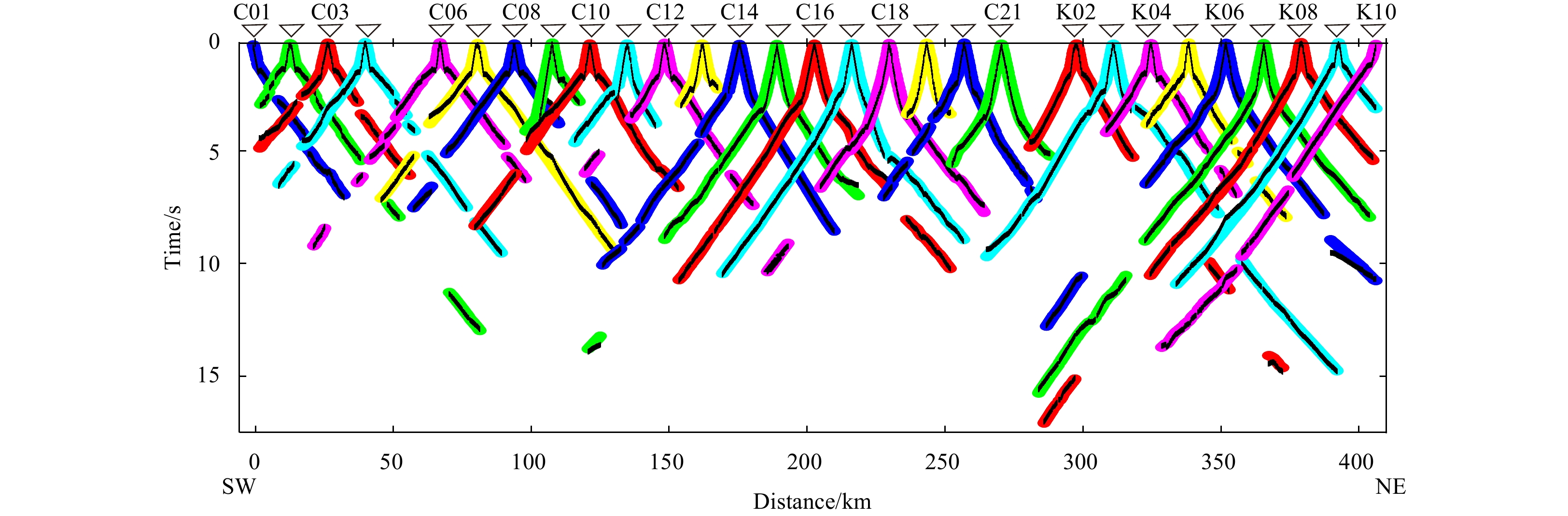
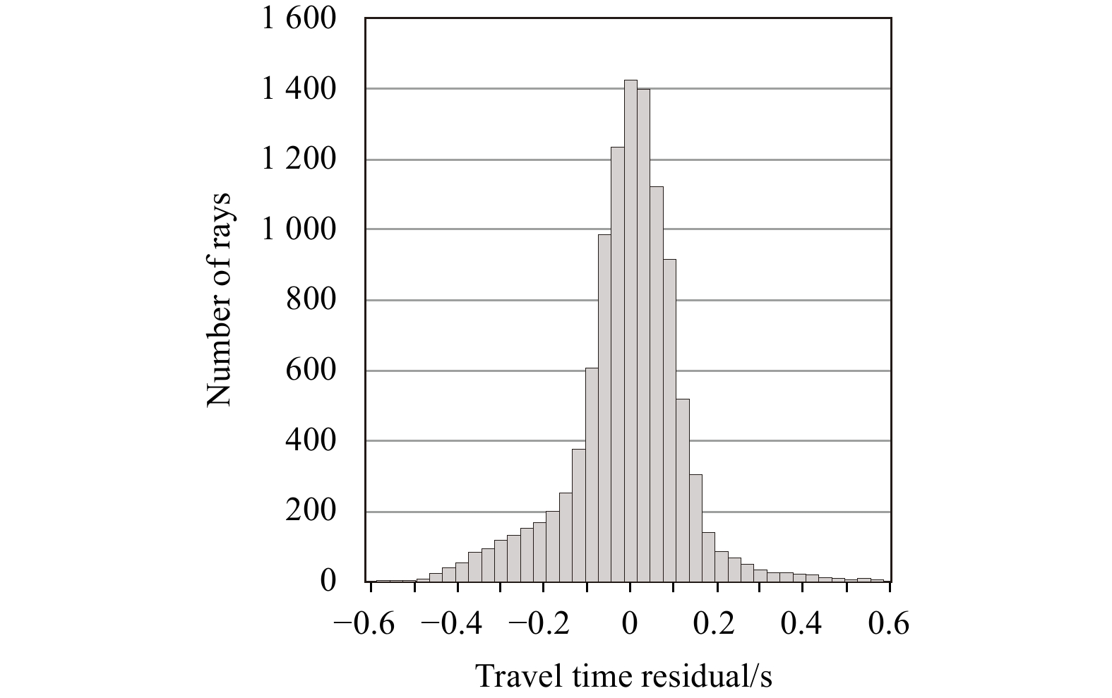
The South Yellow Sea basin is filled with Mesozoic–Cenozoic continental sediments overlying pre-Palaeozoic and Mesozoic–Palaeozoic marine sediments. Conventional multi-channel seismic data cannot describe the velocity structure of the marine residual basin in detail, leading to the lack of a deeper understanding of the distribution and lithology owing to strong energy shielding on the top interface of marine sediments. In this study, we present seismic tomography data from ocean bottom seismographs that describe the NEE-trending velocity distributions of the basin. The results indicate that strong velocity variations occur at shallow crustal levels. Horizontal velocity bodies show good correlation with surface geological features, and multi-layer features exist in the vertical velocity framework (depth: 0–10 km). The analyses of the velocity model, gravity data, magnetic data, multi-channel seismic profiles, and drilling data showed that high-velocity anomalies (>6.5 km/s) of small (thickness: 1–2 km) and large (thickness: >5 km) scales were caused by igneous complexes in the multi-layer structure, which were active during the Palaeogene. Possible locations of good Mesozoic and Palaeozoic marine strata are limited to the Central Uplift and the western part of the Northern Depression along the wide-angle ocean bottom seismograph array. Following the Indosinian movement, a strong compression existed in the Northern Depression during the extensional phase that caused the formation of folds in the middle of the survey line. This study is useful for reconstructing the regional tectonic evolution and delineating the distribution of the marine residual basin in the South Yellow Sea basin.
The South Yellow Sea basin is filled with Mesozoic–Cenozoic continental sediments overlying pre-Palaeozoic and Mesozoic–Palaeozoic marine sediments. Conventional multi-channel seismic data cannot describe the velocity structure of the marine residual basin in detail, leading to the lack of a deeper understanding of the distribution and lithology owing to strong energy shielding on the top interface of marine sediments. In this study, we present seismic tomography data from ocean bottom seismographs that describe the NEE-trending velocity distributions of the basin. The results indicate that strong velocity variations occur at shallow crustal levels. Horizontal velocity bodies show good correlation with surface geological features, and multi-layer features exist in the vertical velocity framework (depth: 0–10 km). The analyses of the velocity model, gravity data, magnetic data, multi-channel seismic profiles, and drilling data showed that high-velocity anomalies (>6.5 km/s) of small (thickness: 1–2 km) and large (thickness: >5 km) scales were caused by igneous complexes in the multi-layer structure, which were active during the Palaeogene. Possible locations of good Mesozoic and Palaeozoic marine strata are limited to the Central Uplift and the western part of the Northern Depression along the wide-angle ocean bottom seismograph array. Following the Indosinian movement, a strong compression existed in the Northern Depression during the extensional phase that caused the formation of folds in the middle of the survey line. This study is useful for reconstructing the regional tectonic evolution and delineating the distribution of the marine residual basin in the South Yellow Sea basin.


2023, 42(2): 120-133.
doi: 10.1007/s13131-022-2125-y
Abstract:
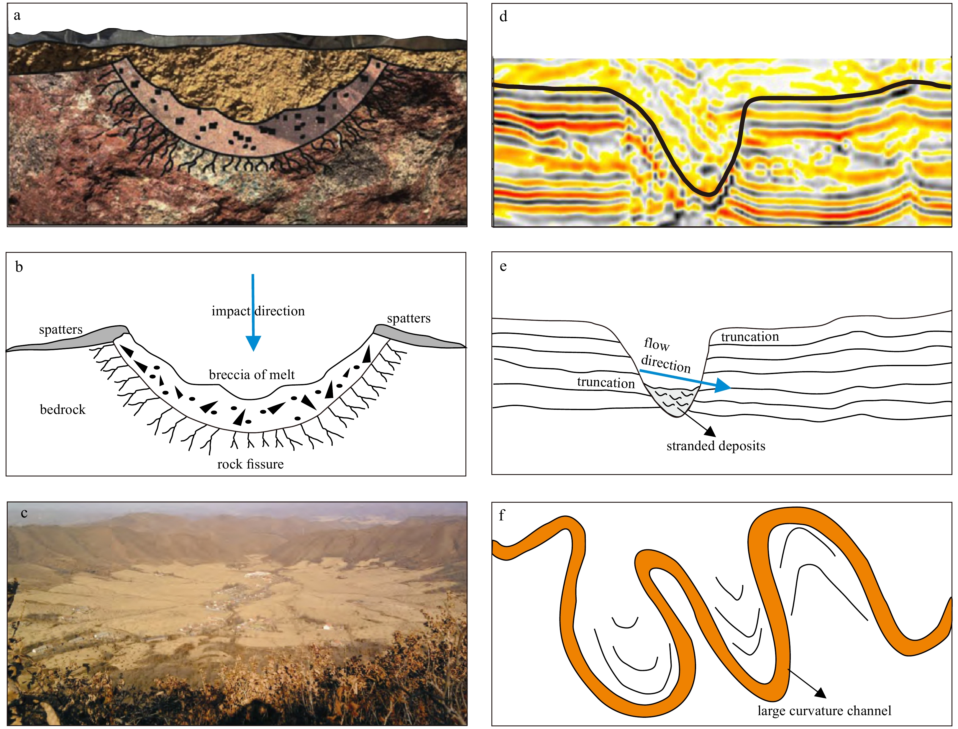
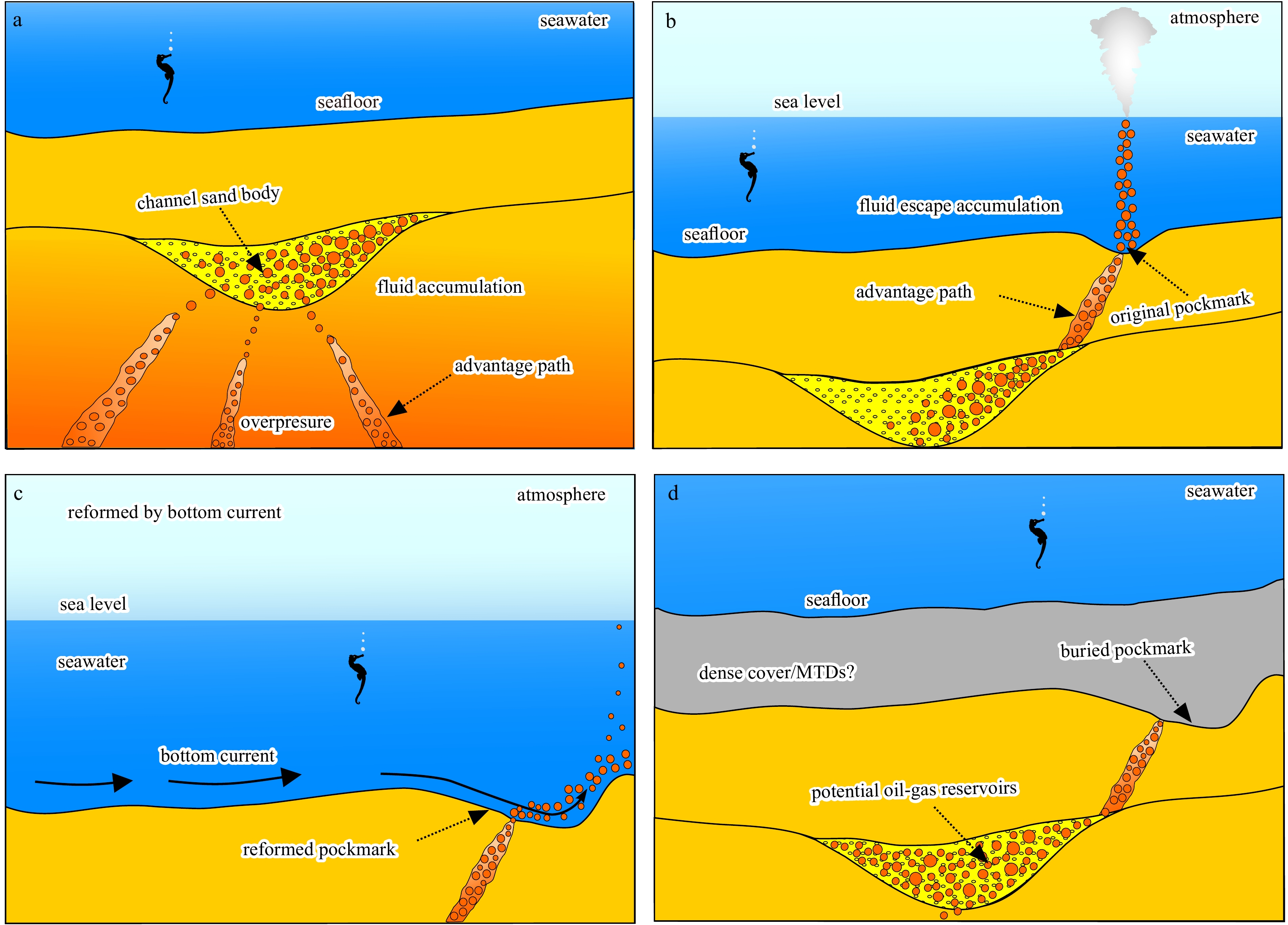
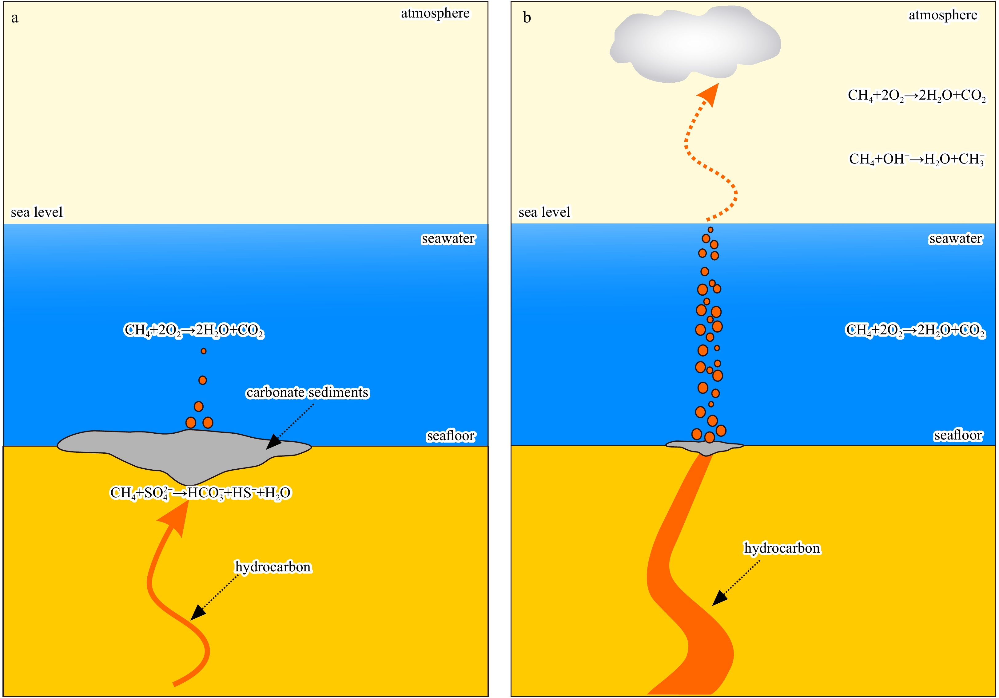
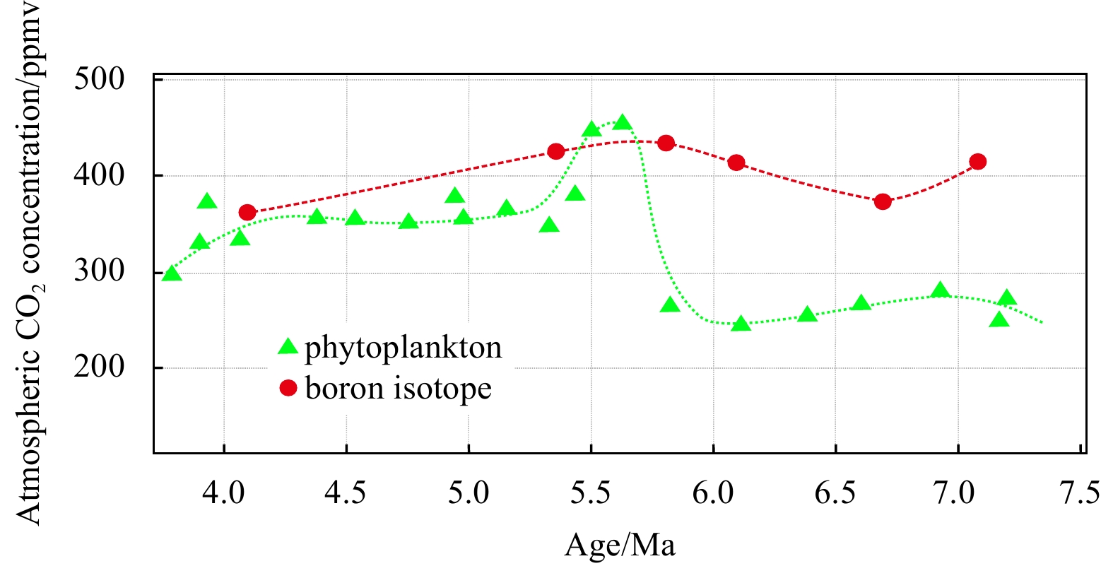
In the late Miocene, giant ancient pockmarks, which are fairly rare globally, developed in the Qiongdongnan Basin. In this paper, to determine the sedimentary characteristics and genetic mechanism of these giant ancient pockmarks in the Yinggehai Formation of the Qiongdongnan Basin, based on high-resolution 3D seismic data and multiattribute fusion technologies, we analyzed the planar distribution and seismic facies of the ancient pockmarks and compared the characteristics of the ancient pockmarks with those of channels, craters, and hydrate pits. Moreover, we also discussed the implications of the fluid escape system and paleo-bottom current activity in the ancient pockmark development area and analyzed the influence of the ancient pockmarks on the paleoclimate in this region. Finally, an evolutionary model was proposed for the giant ancient pockmarks. This model shows that the giant ancient pockmarks in the southern Qiongdongnan Basin were affected by both deep fluid escape and lateral transformation of paleobottom currents. In addition, the giant ancient pockmarks contributed to the atmospheric CO2 concentration in the late Miocene and played a great role in the contemporary evaluation of deepwater petroleum exploration.
In the late Miocene, giant ancient pockmarks, which are fairly rare globally, developed in the Qiongdongnan Basin. In this paper, to determine the sedimentary characteristics and genetic mechanism of these giant ancient pockmarks in the Yinggehai Formation of the Qiongdongnan Basin, based on high-resolution 3D seismic data and multiattribute fusion technologies, we analyzed the planar distribution and seismic facies of the ancient pockmarks and compared the characteristics of the ancient pockmarks with those of channels, craters, and hydrate pits. Moreover, we also discussed the implications of the fluid escape system and paleo-bottom current activity in the ancient pockmark development area and analyzed the influence of the ancient pockmarks on the paleoclimate in this region. Finally, an evolutionary model was proposed for the giant ancient pockmarks. This model shows that the giant ancient pockmarks in the southern Qiongdongnan Basin were affected by both deep fluid escape and lateral transformation of paleobottom currents. In addition, the giant ancient pockmarks contributed to the atmospheric CO2 concentration in the late Miocene and played a great role in the contemporary evaluation of deepwater petroleum exploration.


2023, 42(2): 134-141.
doi: 10.1007/s13131-022-2120-3
Abstract:
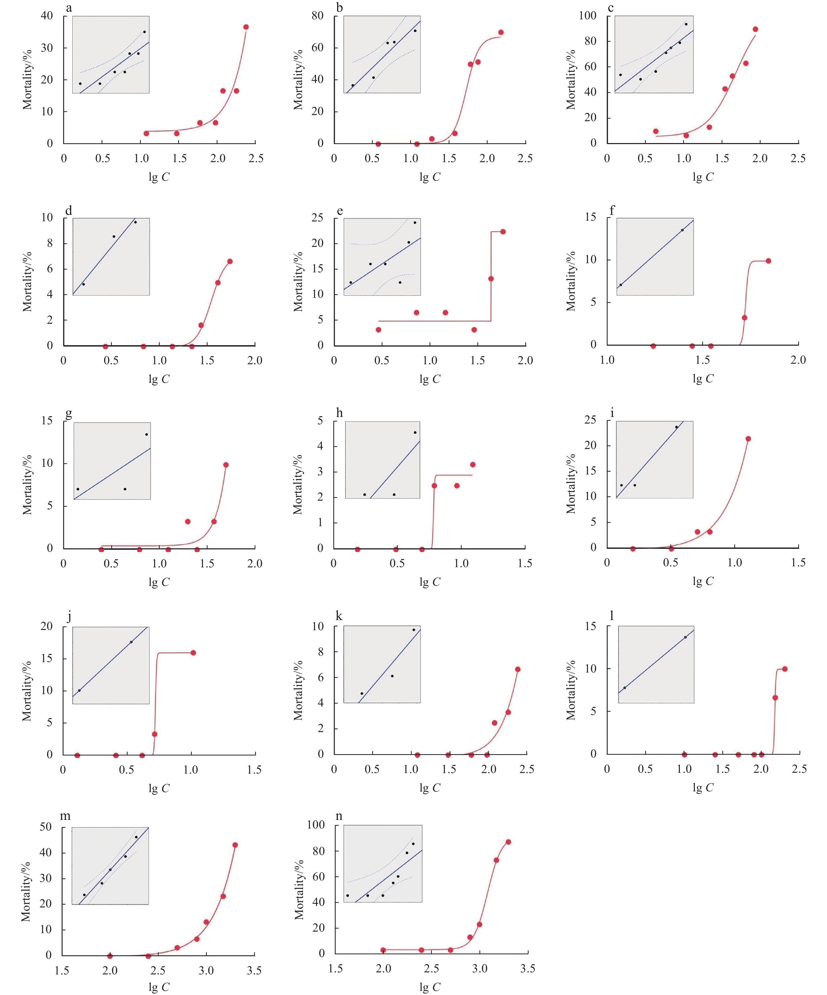
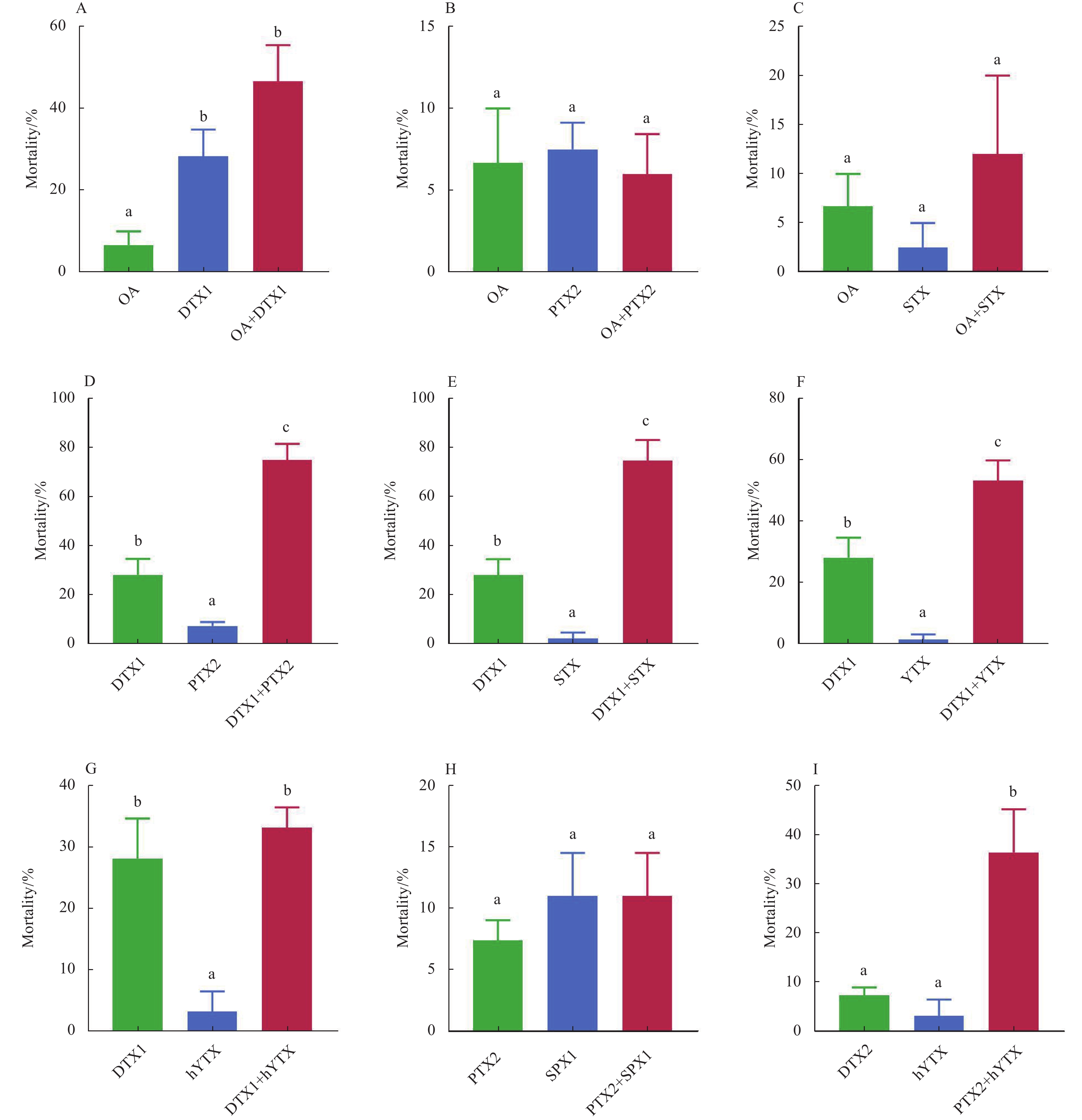
Toxic harmful algal blooms (HABs) can cause deleterious effects in marine organisms, threatening the stability of marine ecosystems. It is well known that different strains, natural populations and growth conditions of the same toxic algal species may lead to different amount of phycotoxin production and the ensuing toxicity. To fully assess the ecological risk of toxic HABs, it is of great importance to investigate the toxic effects of phycotoxins in marine organisms. In this study, the short-term toxicity of 14 common phycotoxins (alone and in combination) in the marine zooplankton Artemia salina was investigated. The 48 h LC50 of the 14 phycotoxins varied from 0.019 3 µg/mL to 2.415 µg/mL. The most potent phycotoxin was azaspiracids-3 (AZA3; with a LC50 of 0.019 3 µg/mL), followed by azaspiracids-2 (AZA2; 0.022 6 µg/mL), pectenotoxin-2 (PTX2; 0.046 0 µg/mL) and dinophysistoxin-1 (DTX1; 0.081 8 µg/mL). For the binary exposure, okadaic acid (OA) induced potential additive effects with DTX1, probably due to their similar structure (polyether fatty acid) and mode of action (attacking the serine/threonine phosphoprotein phosphatases). On the other hand, OA showed potential antagonistic effects with PTX2, which might be accounted for by their activation on the detoxification activity of cytochrome P450 activity. In addition, DTX1 induced potential synergetic effects with saxitoxin (STX), yessotoxin (YTX) or PTX2, suggesting the hazard potency of the mixtures of DTX1 and other phycotoxins (like STX, YTX and PTX2) with regard to the ecological risk. These results provide valuable toxicological data for assessing the impact of phycotoxins on marine planktonic species and highlight the potential ecological risk of toxic HABs in marine ecosystems.
Toxic harmful algal blooms (HABs) can cause deleterious effects in marine organisms, threatening the stability of marine ecosystems. It is well known that different strains, natural populations and growth conditions of the same toxic algal species may lead to different amount of phycotoxin production and the ensuing toxicity. To fully assess the ecological risk of toxic HABs, it is of great importance to investigate the toxic effects of phycotoxins in marine organisms. In this study, the short-term toxicity of 14 common phycotoxins (alone and in combination) in the marine zooplankton Artemia salina was investigated. The 48 h LC50 of the 14 phycotoxins varied from 0.019 3 µg/mL to 2.415 µg/mL. The most potent phycotoxin was azaspiracids-3 (AZA3; with a LC50 of 0.019 3 µg/mL), followed by azaspiracids-2 (AZA2; 0.022 6 µg/mL), pectenotoxin-2 (PTX2; 0.046 0 µg/mL) and dinophysistoxin-1 (DTX1; 0.081 8 µg/mL). For the binary exposure, okadaic acid (OA) induced potential additive effects with DTX1, probably due to their similar structure (polyether fatty acid) and mode of action (attacking the serine/threonine phosphoprotein phosphatases). On the other hand, OA showed potential antagonistic effects with PTX2, which might be accounted for by their activation on the detoxification activity of cytochrome P450 activity. In addition, DTX1 induced potential synergetic effects with saxitoxin (STX), yessotoxin (YTX) or PTX2, suggesting the hazard potency of the mixtures of DTX1 and other phycotoxins (like STX, YTX and PTX2) with regard to the ecological risk. These results provide valuable toxicological data for assessing the impact of phycotoxins on marine planktonic species and highlight the potential ecological risk of toxic HABs in marine ecosystems.
2023, 42(2): 142-149.
doi: 10.1007/s13131-022-2112-3
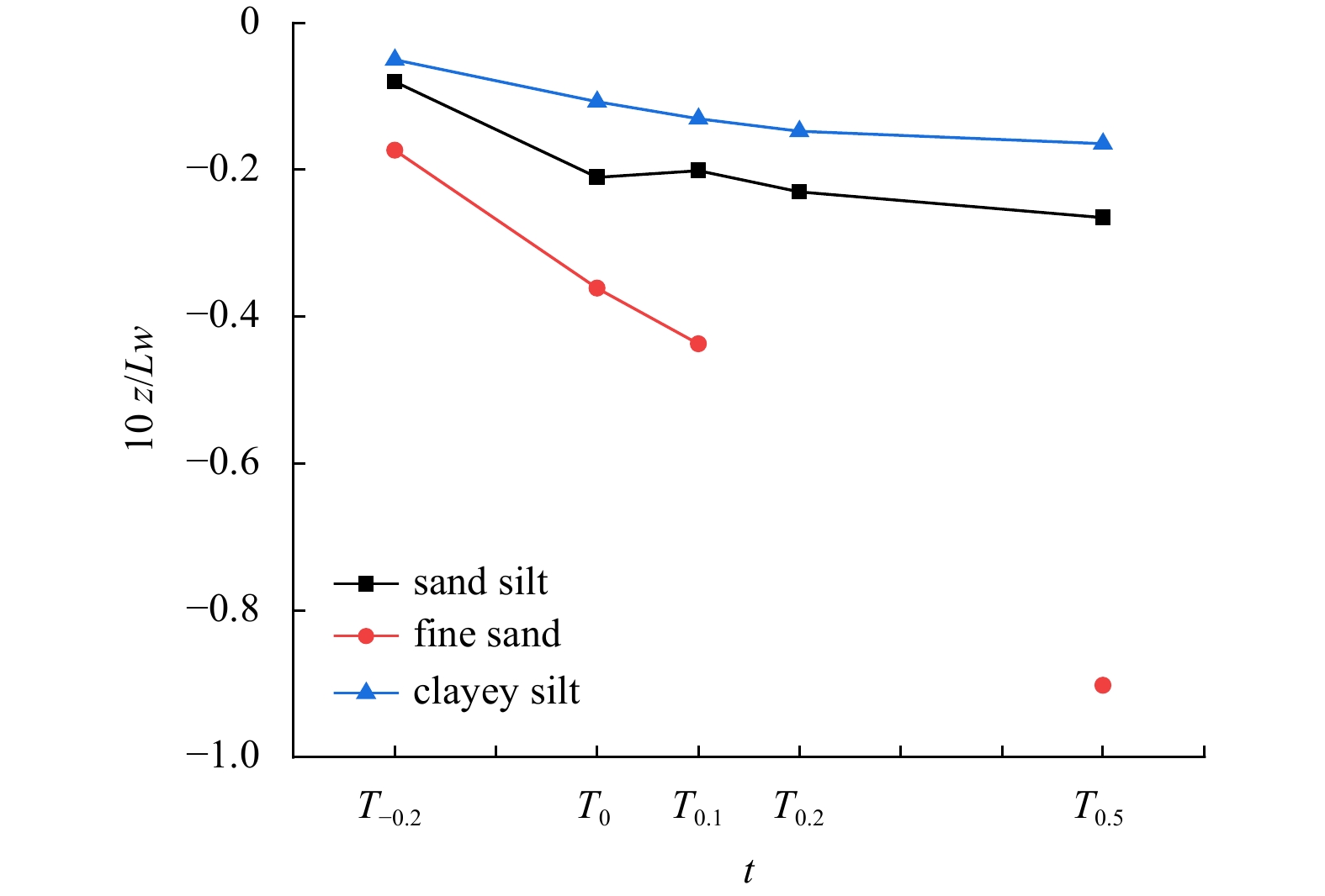
Abstract:
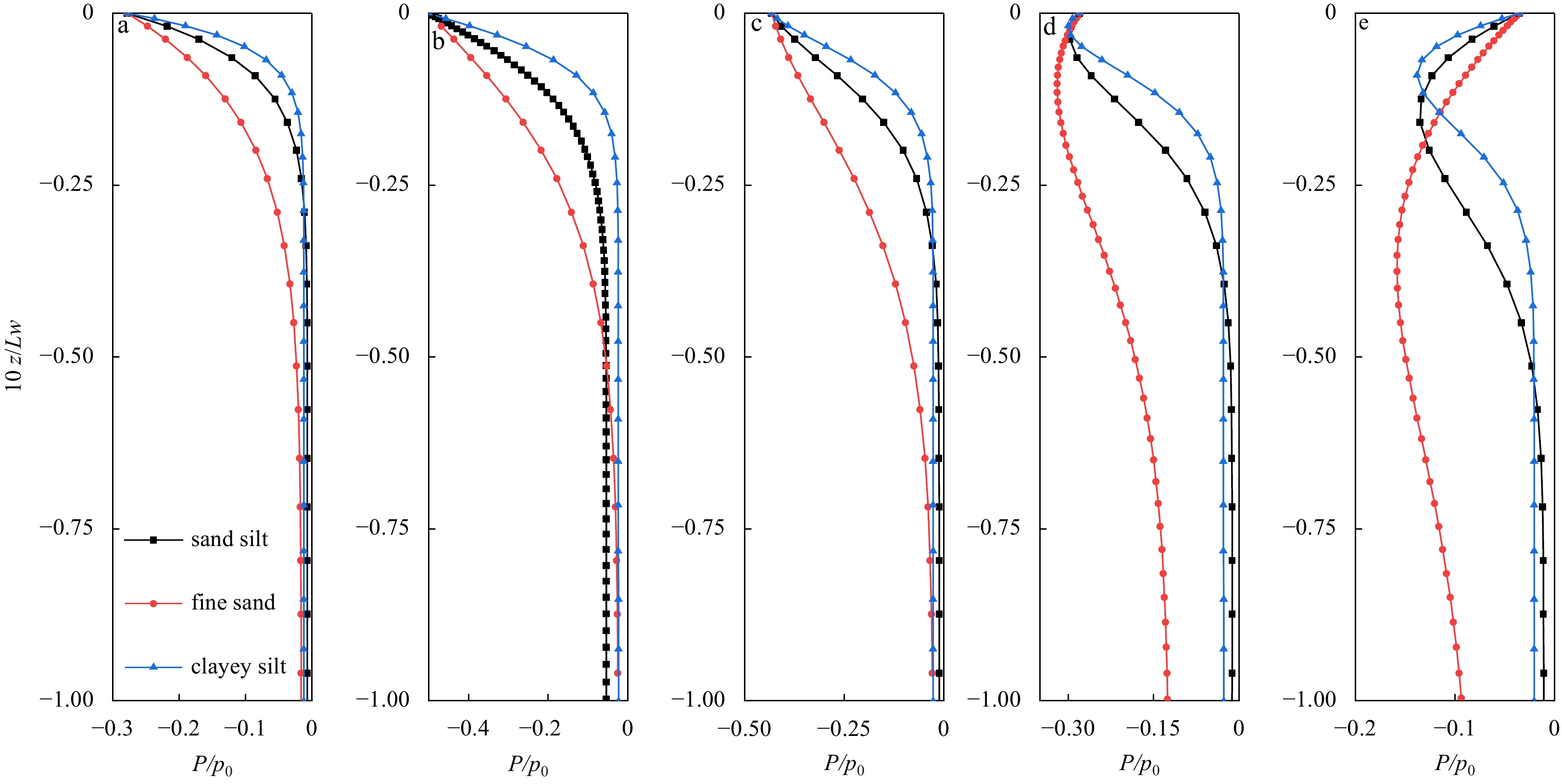
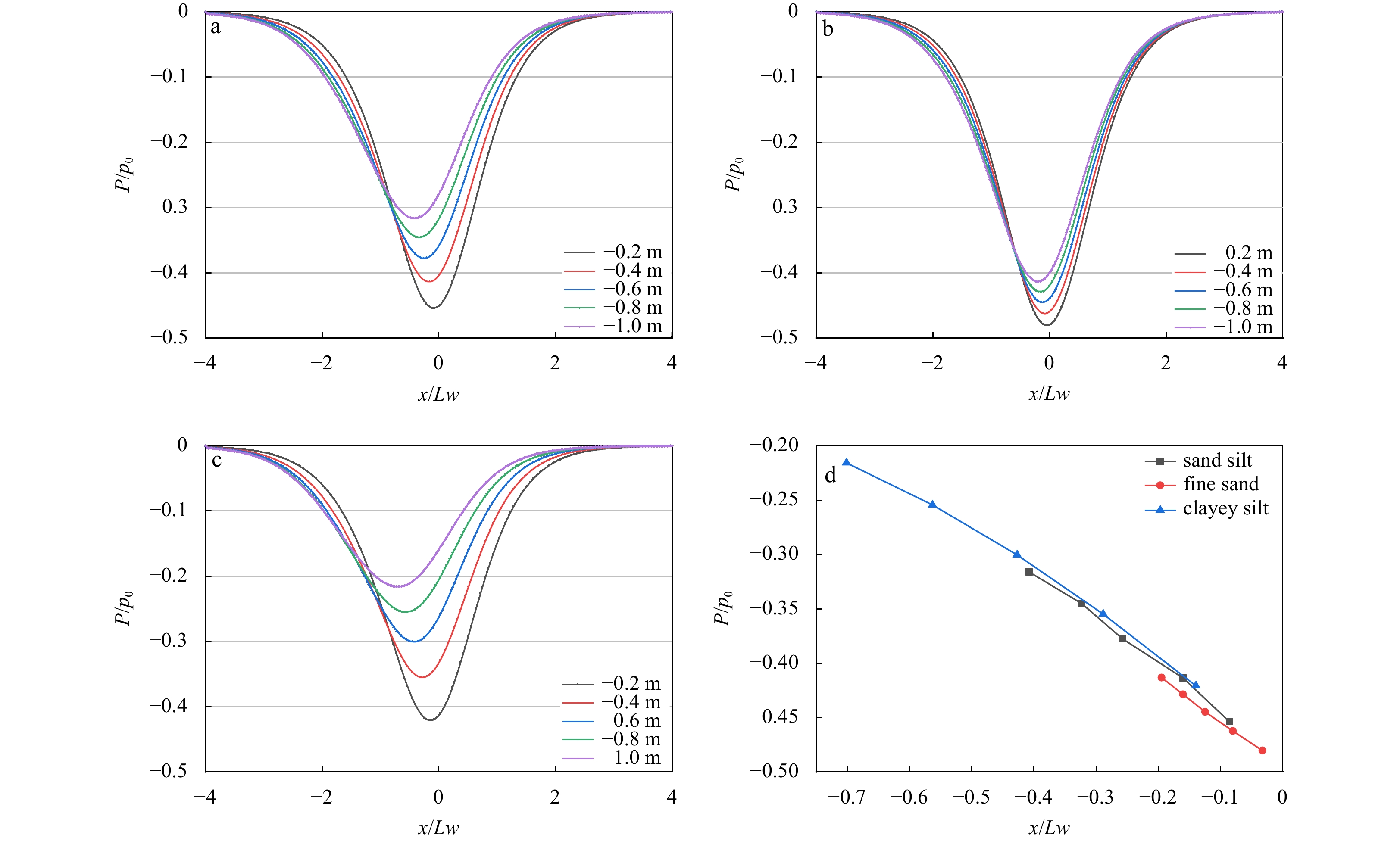
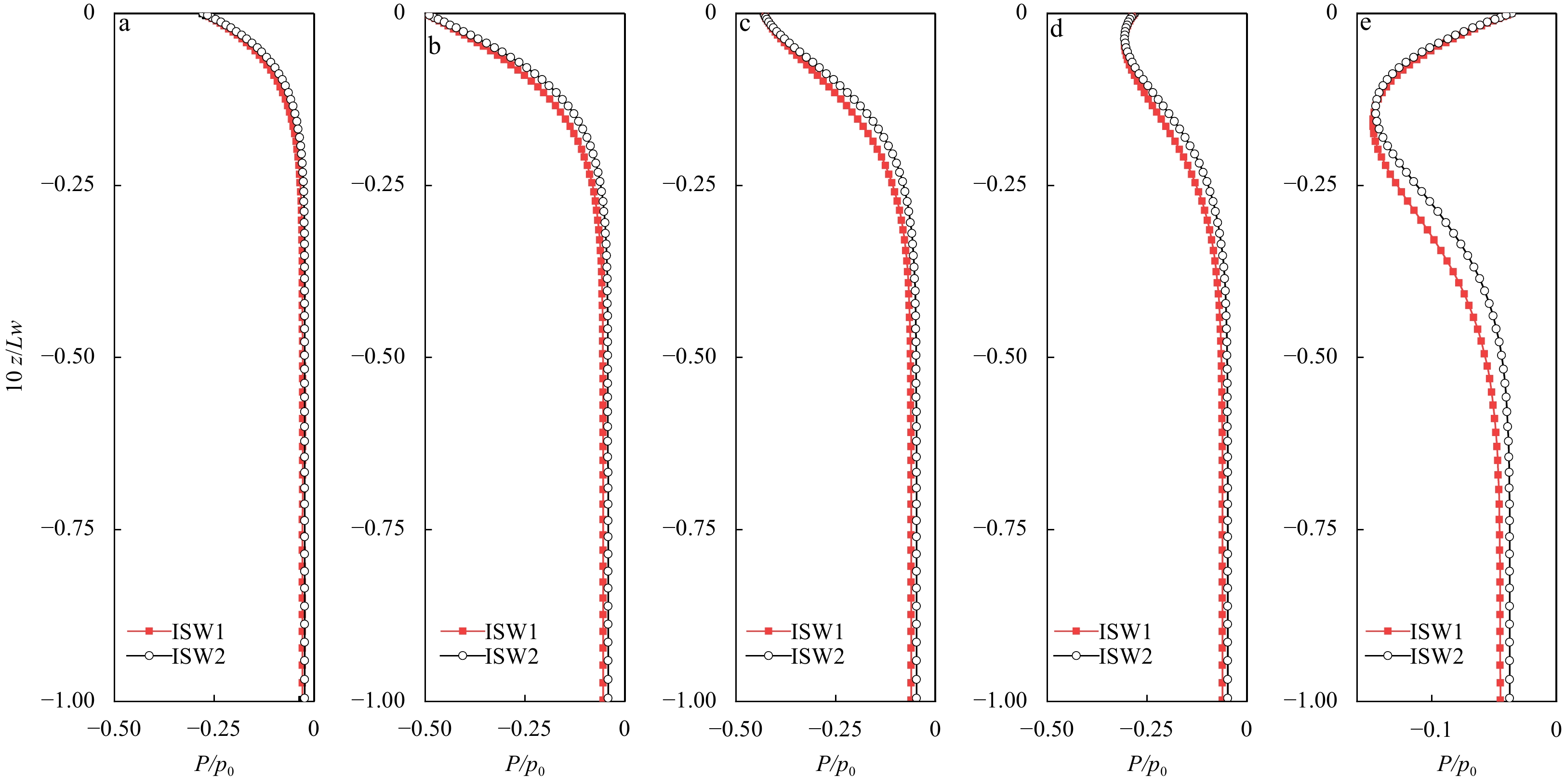
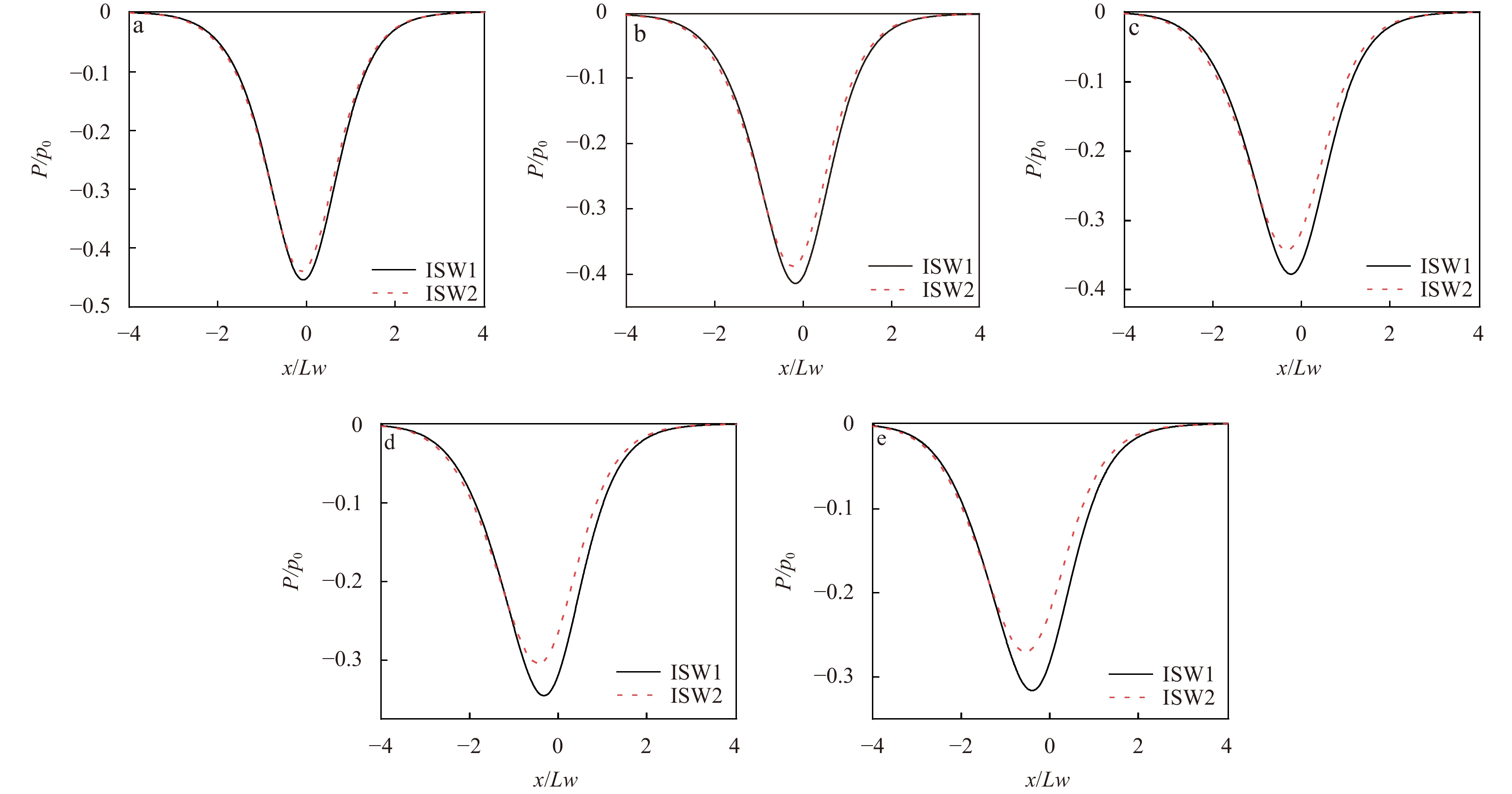
Internal solitary wave (ISW) is often accompanied by huge energy transport, which will change the pore water pressure in the seabed. Based on the two-dimensional Biot consolidation theory, the excess pore water pressure in seabed was simulated, and the spatiotemporal distribution characteristics of excess pore water pressure was studied. As the parameters of both ISW and seabed can affect the excess pore water pressure, the distribution of pore water pressure showed both dissipation and phase lag. And parametric studies were done on these two phenomena. Due to influenced by the phase lag of excess pore water pressure, the penetration depth under the site of northern South China Sea with total water depth 327 m, induced by typical internal solitary wave increased by 26.19%, 53.27% and 149.86% from T0 to T0.5 in sand silt, clayey silt and fine sand seabed, respectively. That means the effect of ISW on seabed will be underestimated if we only take into accout the penetration depth under ISW trough, especially for fine sand seabed. In addition, the concept of “amplitude-depth ratio” had been introduced to describe the influence of ISW on seabed dynamic response in the actual marine environment. In present study, it is negatively correlated with the excess pore water pressure, and an ISW with smaller amplitude-depth ratio can wide the range of lateral impacts. Our study results help understand the seabed damage induced by the interaction between ISW and seabed.
Internal solitary wave (ISW) is often accompanied by huge energy transport, which will change the pore water pressure in the seabed. Based on the two-dimensional Biot consolidation theory, the excess pore water pressure in seabed was simulated, and the spatiotemporal distribution characteristics of excess pore water pressure was studied. As the parameters of both ISW and seabed can affect the excess pore water pressure, the distribution of pore water pressure showed both dissipation and phase lag. And parametric studies were done on these two phenomena. Due to influenced by the phase lag of excess pore water pressure, the penetration depth under the site of northern South China Sea with total water depth 327 m, induced by typical internal solitary wave increased by 26.19%, 53.27% and 149.86% from T0 to T0.5 in sand silt, clayey silt and fine sand seabed, respectively. That means the effect of ISW on seabed will be underestimated if we only take into accout the penetration depth under ISW trough, especially for fine sand seabed. In addition, the concept of “amplitude-depth ratio” had been introduced to describe the influence of ISW on seabed dynamic response in the actual marine environment. In present study, it is negatively correlated with the excess pore water pressure, and an ISW with smaller amplitude-depth ratio can wide the range of lateral impacts. Our study results help understand the seabed damage induced by the interaction between ISW and seabed.


2023, 42(2): 150-162.
doi: 10.1007/s13131-022-2063-8
Abstract:
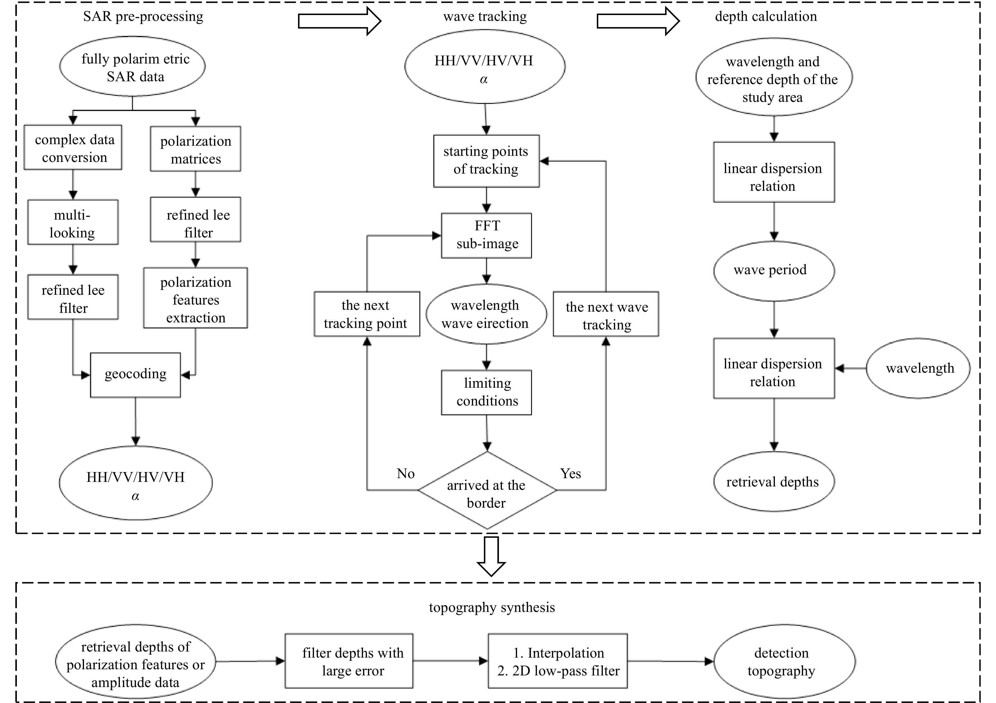
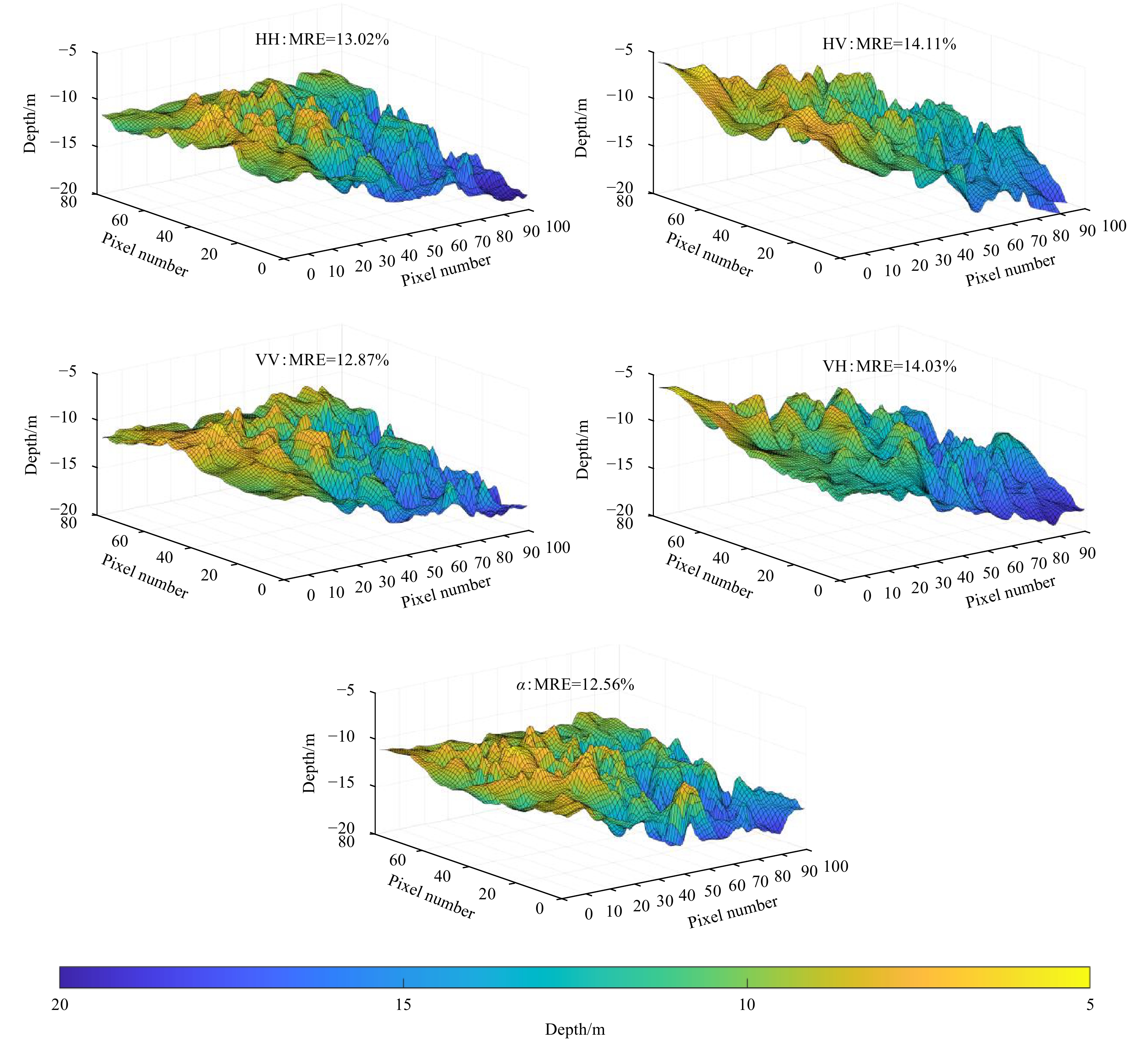
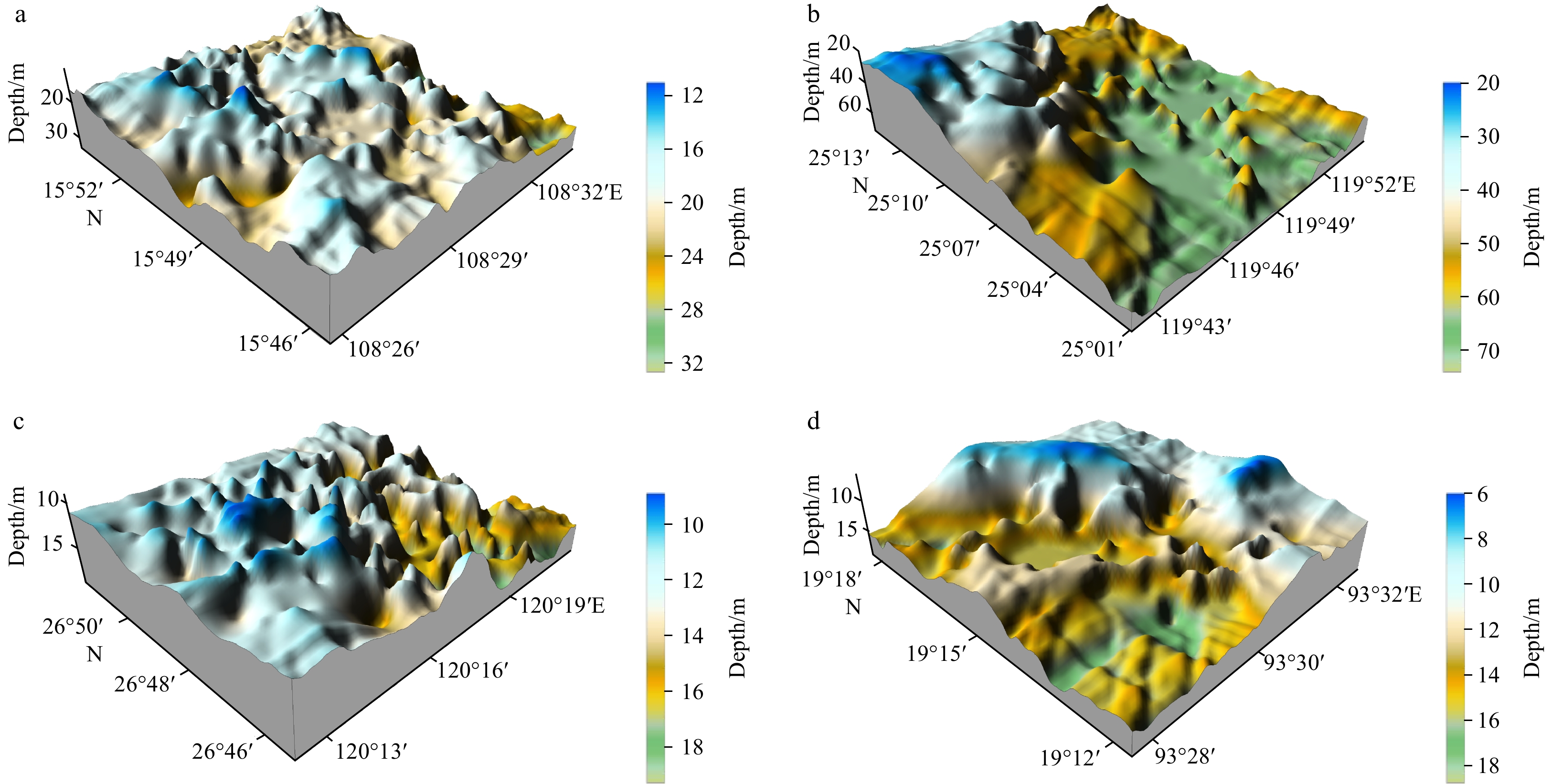
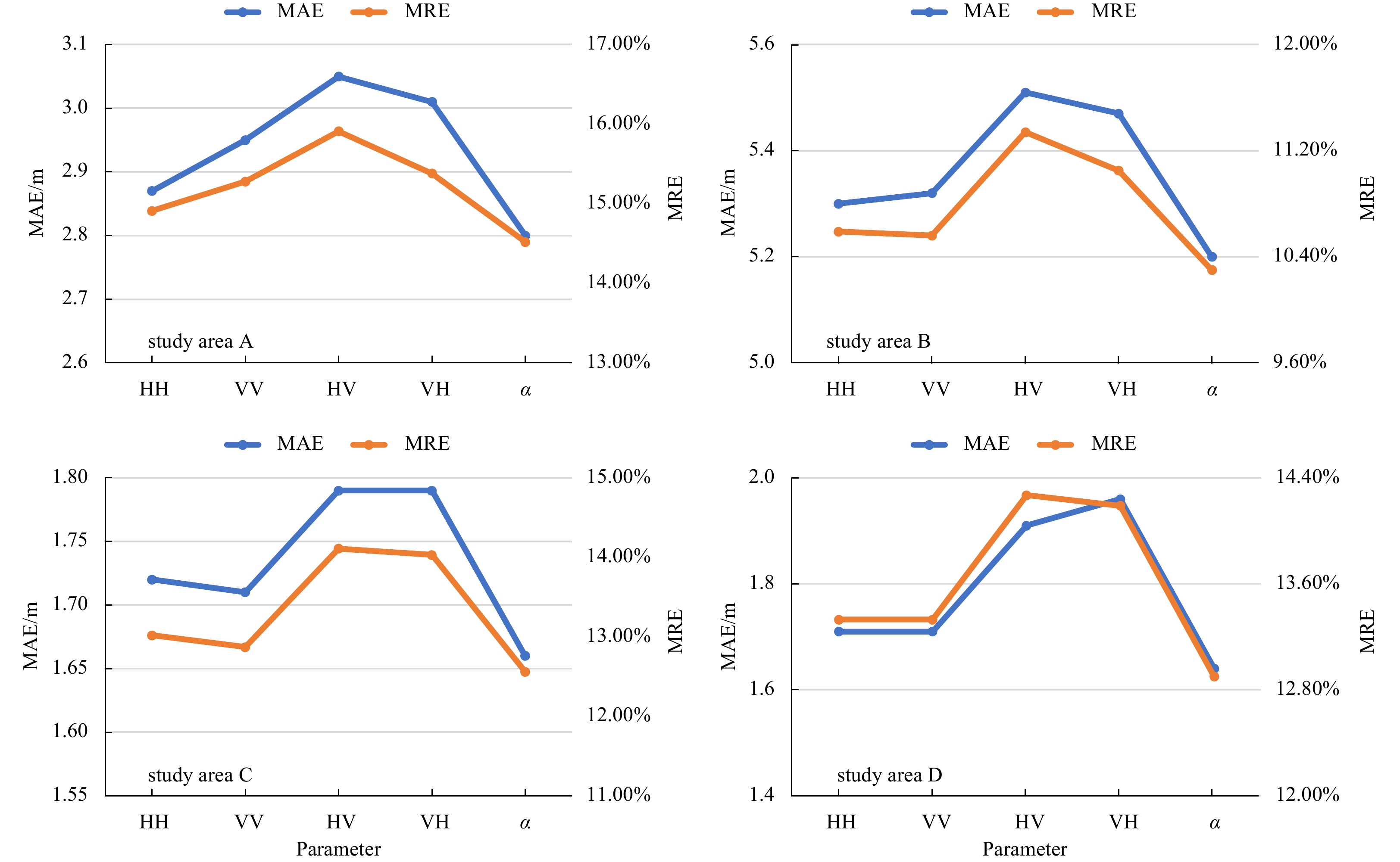
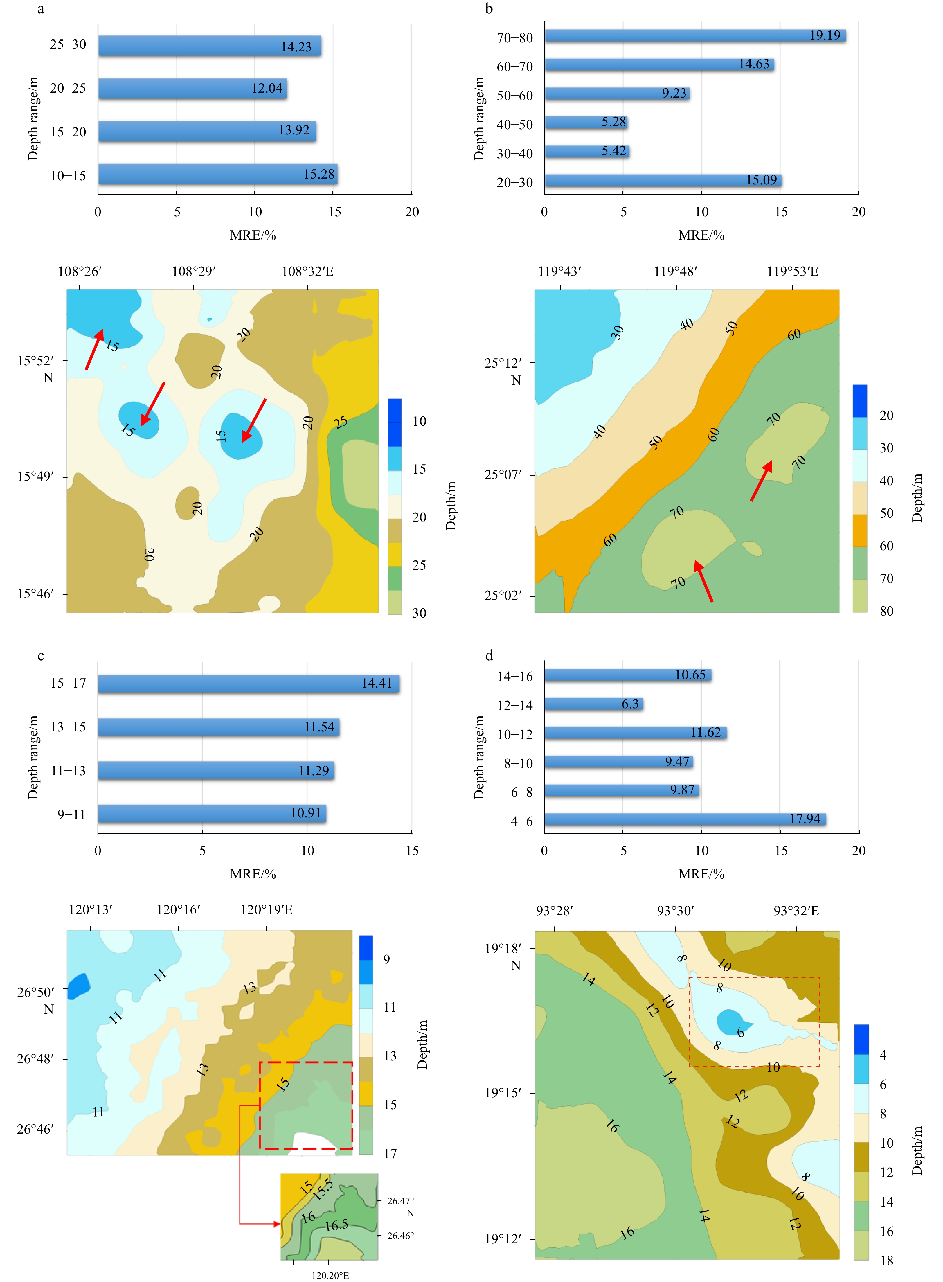
Compared to single-polarization synthetic aperture radar (SAR) data, fully polarimetric SAR data can provide more detailed information of the sea surface, which is important for applications such as shallow sea topography detection. The Gaofen-3 satellite provides abundant polarimetric SAR data for ocean research. In this paper, a shallow sea topography detection method was proposed based on fully polarimetric Gaofen-3 SAR data. This method considers swell patterns and only requires SAR data and little prior knowledge of the water depth to detect shallow sea topography. Wave tracking was performed based on preprocessed fully polarimetric SAR data, and the water depth was then calculated considering the wave parameters and the linear dispersion relationships. In this paper, four study areas were selected for experiments, and the experimental results indicated that the polarimetric scattering parameter α had higher detection accuracy than quad-polarization images. The mean relative errors were 14.52%, 10.30%, 12.56%, and 12.90%, respectively, in the four study areas. In addition, this paper also analyzed the detection ability of this model for different topographies, and the experiments revealed that the topography could be well recognized when the topography gradient is small, the topography gradient direction is close to the wave propagation direction, and the isobath line is regular.
Compared to single-polarization synthetic aperture radar (SAR) data, fully polarimetric SAR data can provide more detailed information of the sea surface, which is important for applications such as shallow sea topography detection. The Gaofen-3 satellite provides abundant polarimetric SAR data for ocean research. In this paper, a shallow sea topography detection method was proposed based on fully polarimetric Gaofen-3 SAR data. This method considers swell patterns and only requires SAR data and little prior knowledge of the water depth to detect shallow sea topography. Wave tracking was performed based on preprocessed fully polarimetric SAR data, and the water depth was then calculated considering the wave parameters and the linear dispersion relationships. In this paper, four study areas were selected for experiments, and the experimental results indicated that the polarimetric scattering parameter α had higher detection accuracy than quad-polarization images. The mean relative errors were 14.52%, 10.30%, 12.56%, and 12.90%, respectively, in the four study areas. In addition, this paper also analyzed the detection ability of this model for different topographies, and the experiments revealed that the topography could be well recognized when the topography gradient is small, the topography gradient direction is close to the wave propagation direction, and the isobath line is regular.


2023, 42(2): 163-174.
doi: 10.1007/s13131-022-2026-0
Abstract:
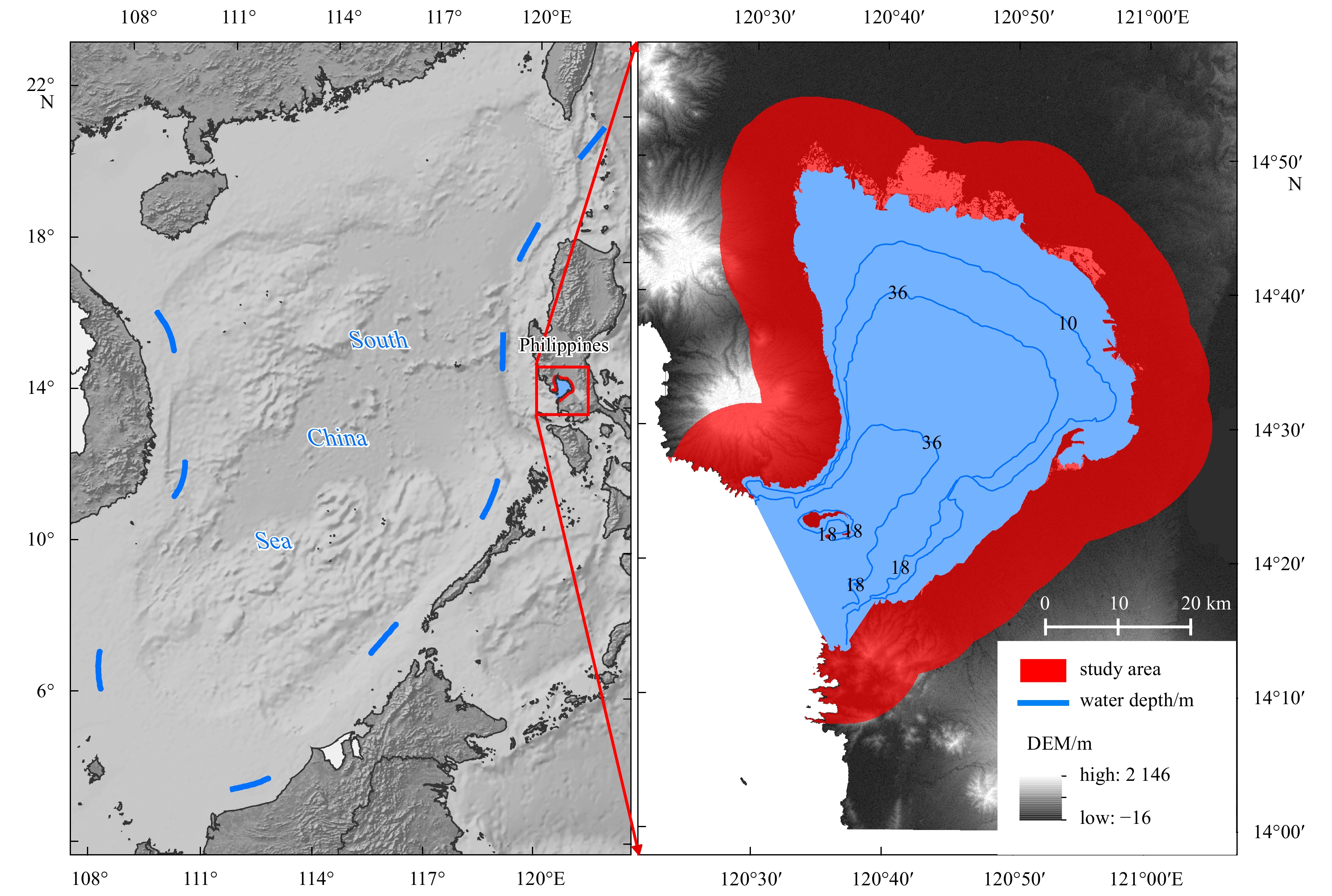
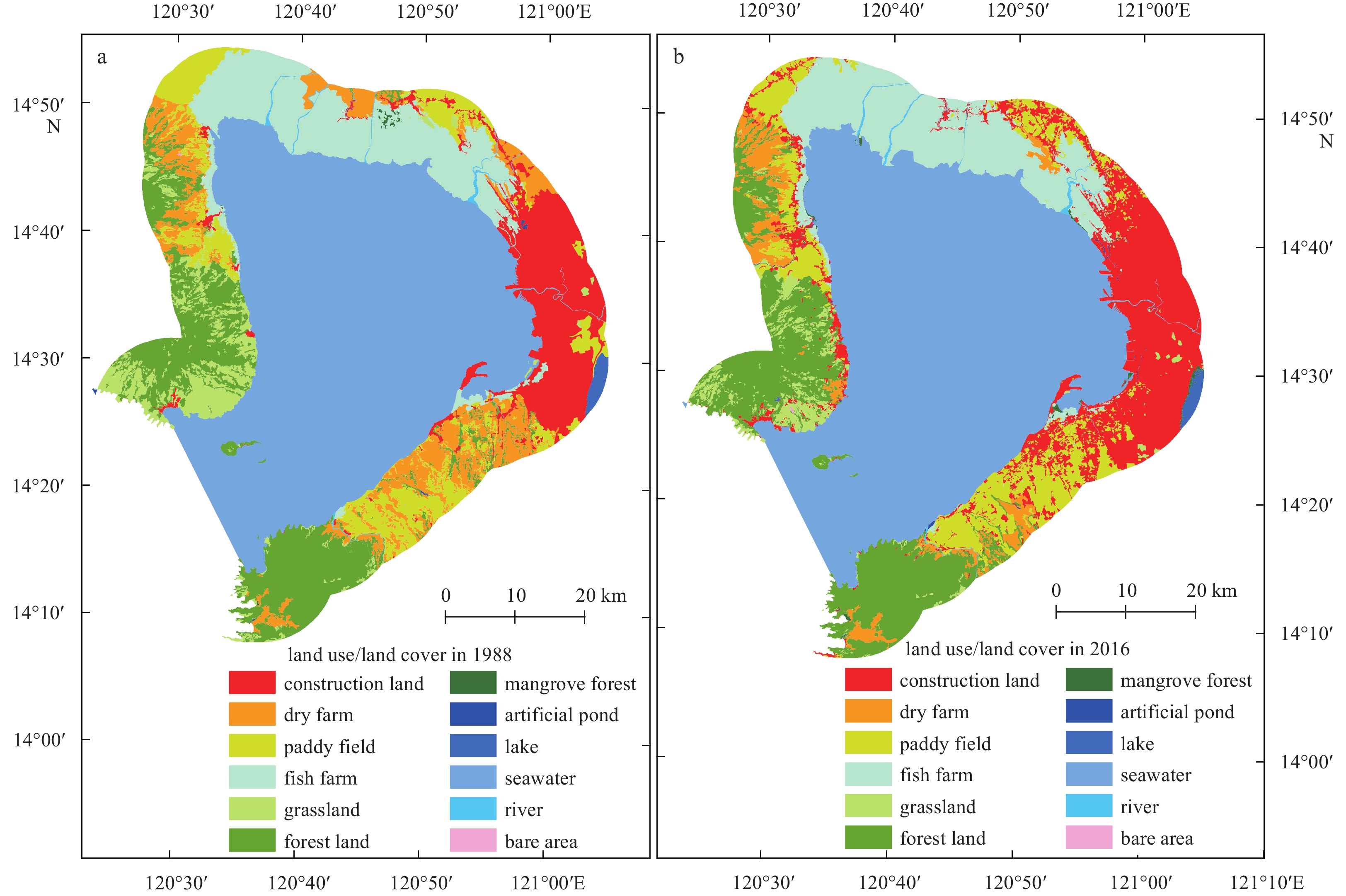
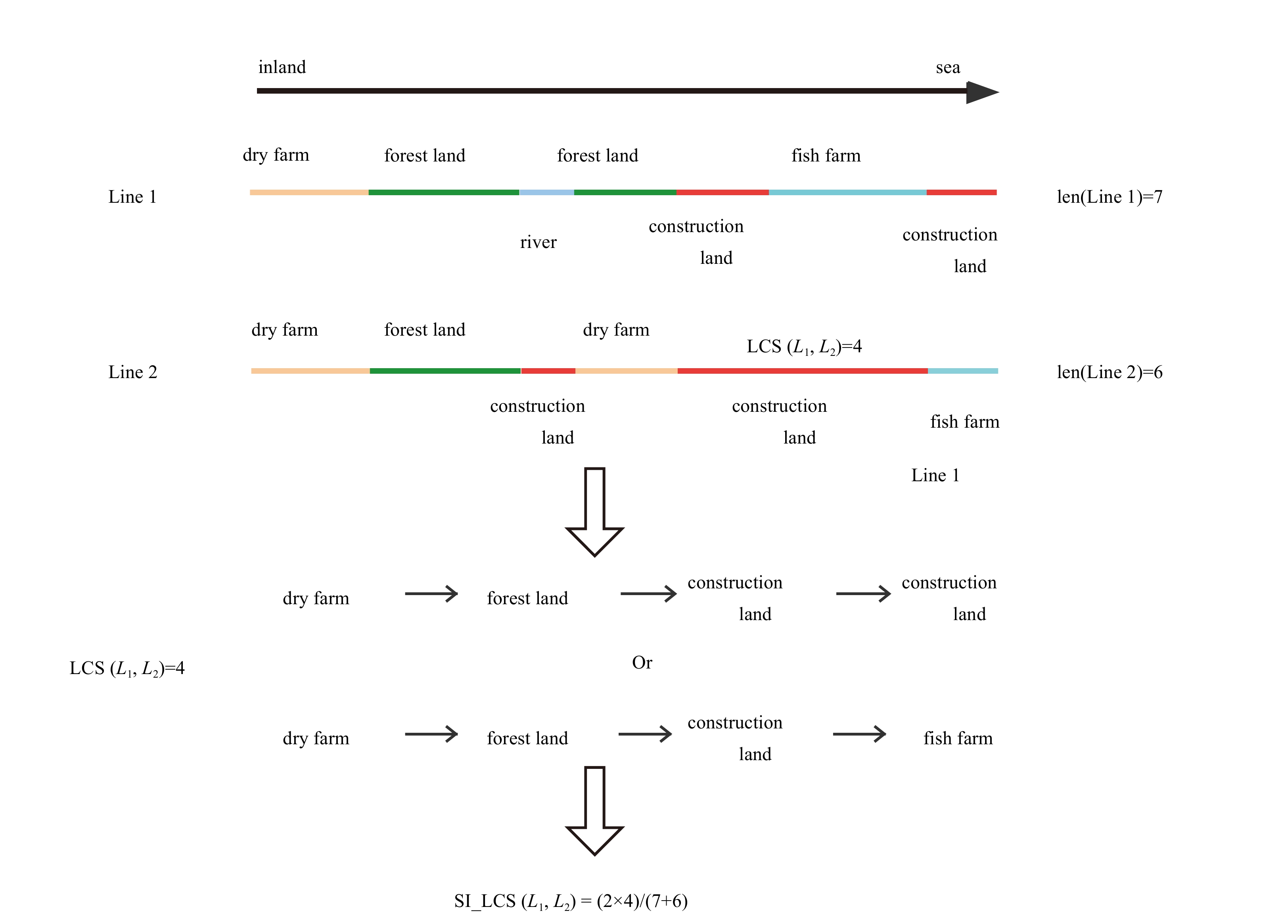
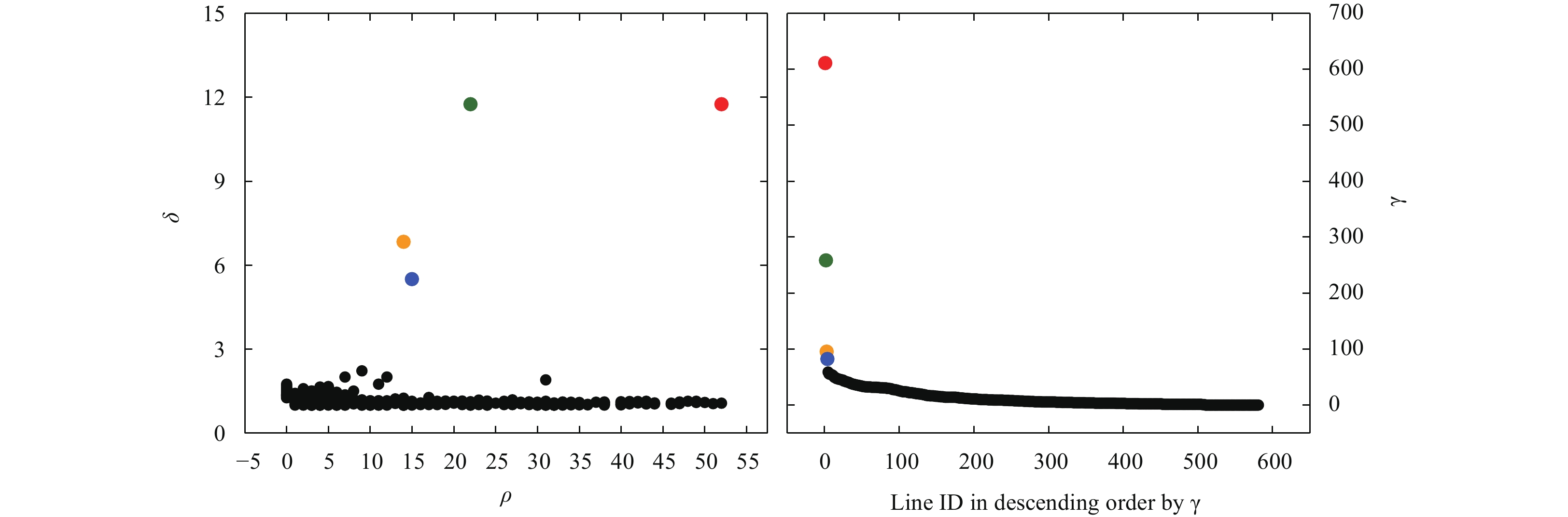
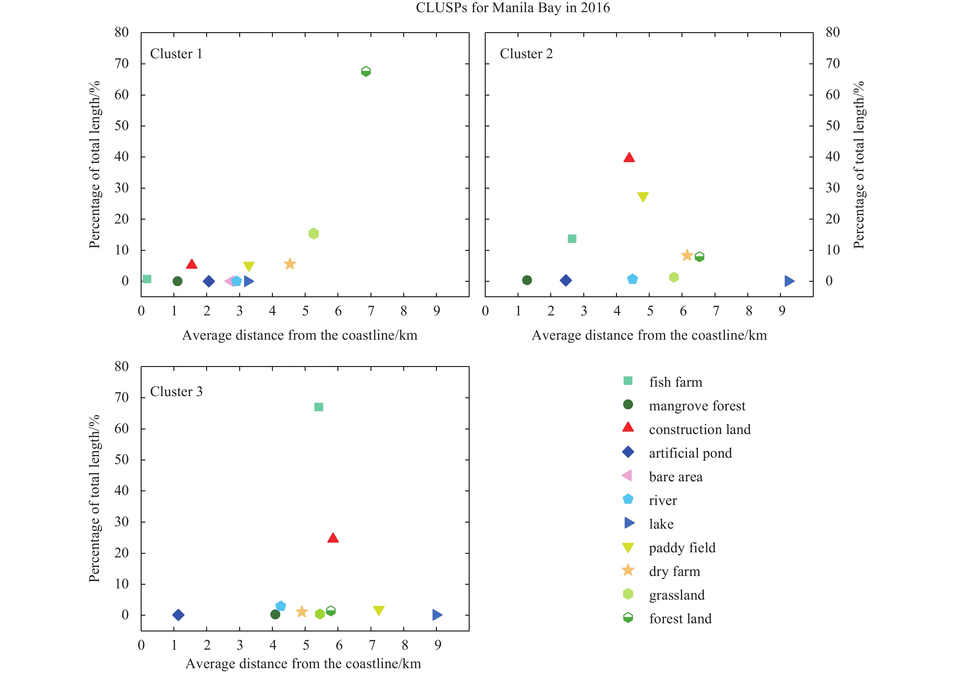
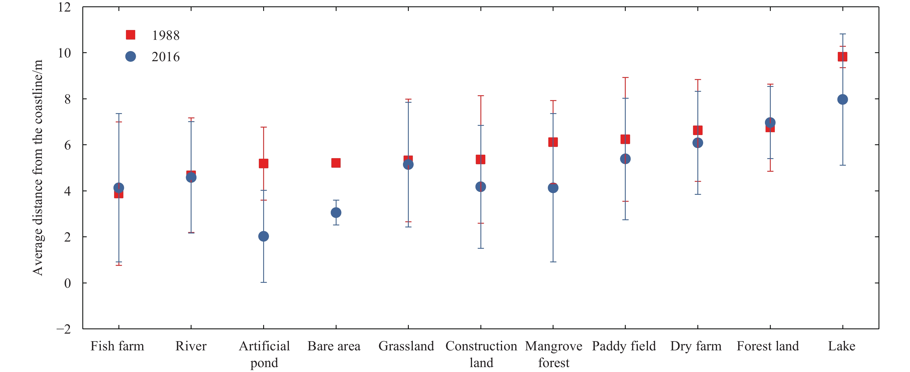
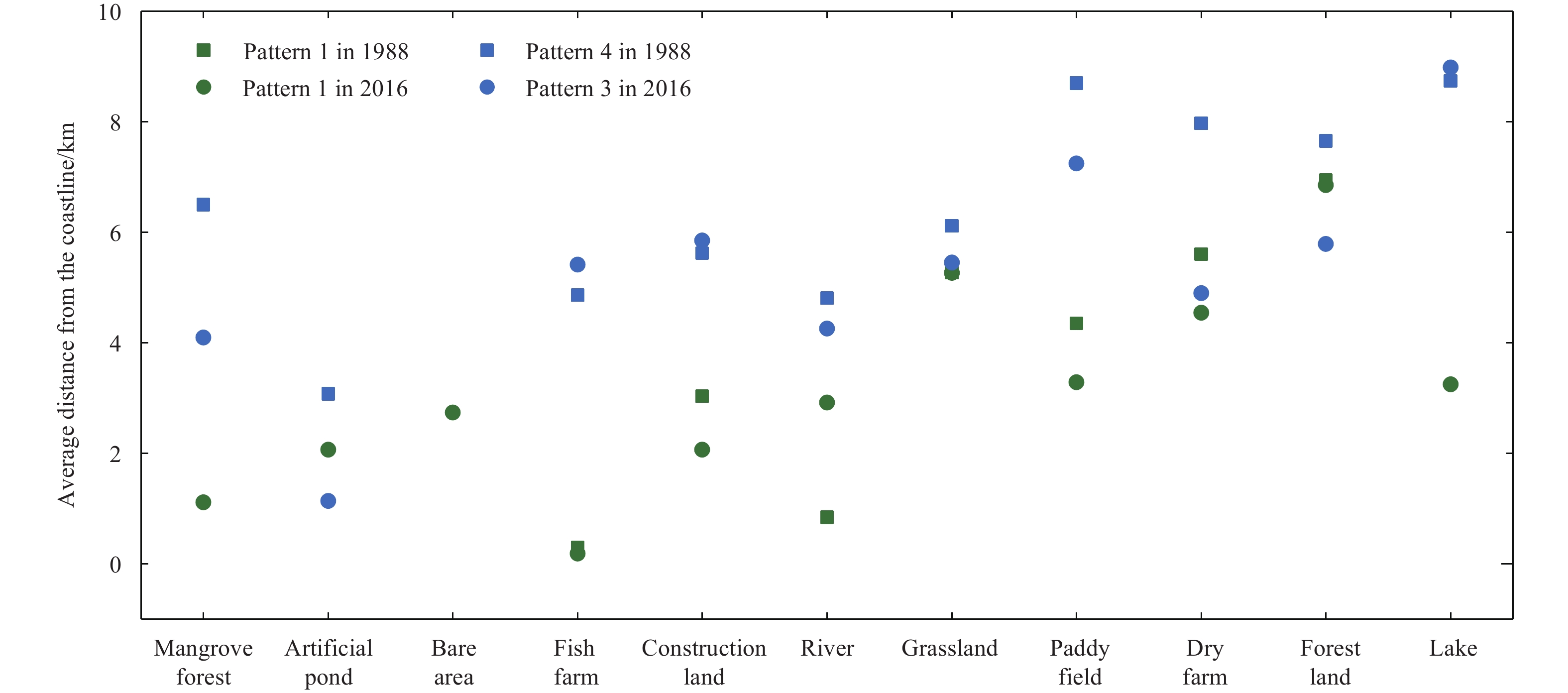
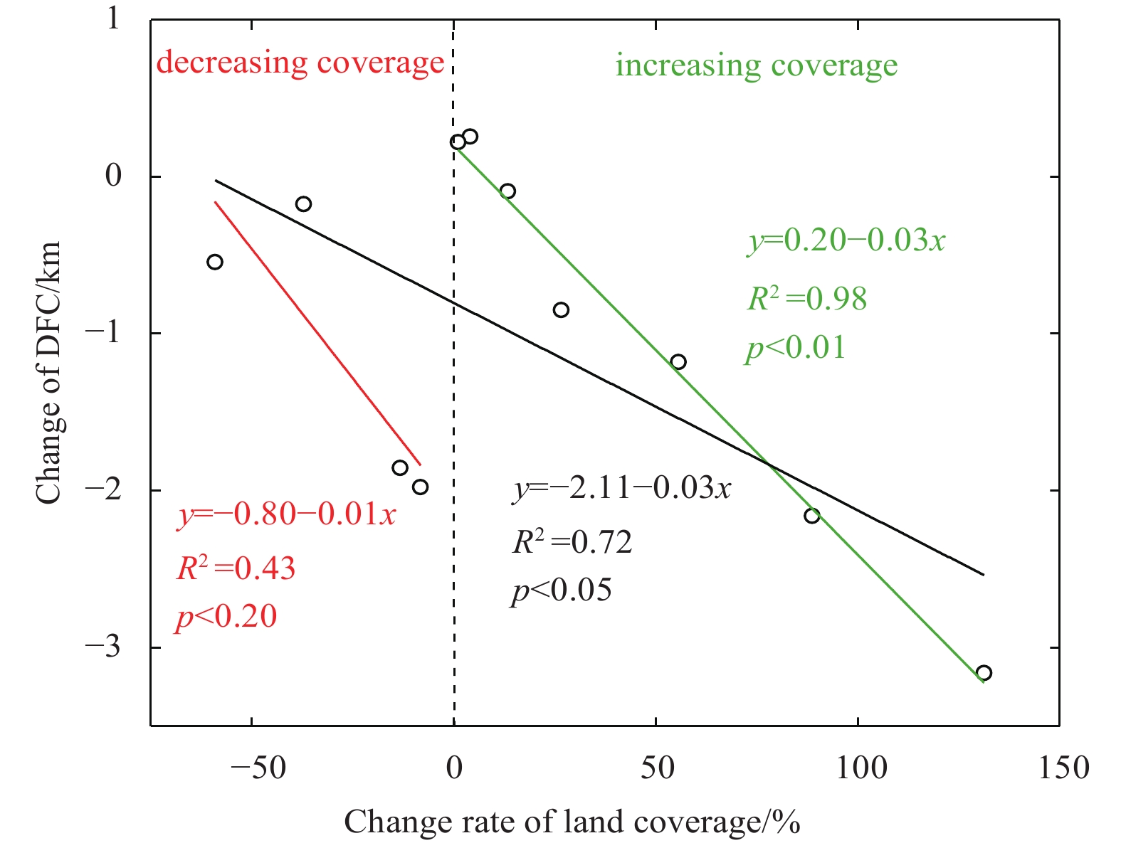
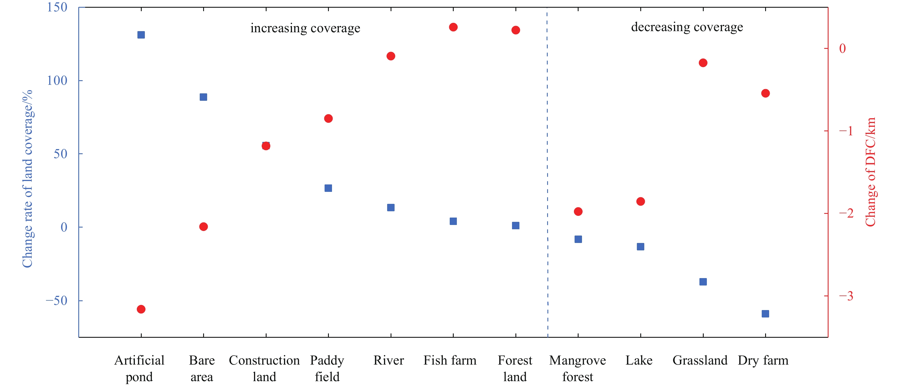
Increasing intense human activities have largely changed the coastal landscape and caused many environmental issues. However, whether human-induced activities could change the coastal land use gradient pattern, an important coastal zonal characteristic along the sea–land direction, remains unclear. Manila Bay was selected as the study area in this work. According to the distance of the land use and land cover (LULC) to the coastline, we clustered the typical coastal land use sequence patterns (CLUSPs) along the sea–land direction between 1988 and 2016 in Manila Bay and found the following. (1) Four typical CLUSPs, including the natural CLUSP dominated by forest land and grassland, the agricultural CLUSP dominated by dry farm and paddy field, the urbanised CLUSP dominated by construction land and the fishery CLUSP dominated by fishing farm, were mined in 1988. Three typical CLUSPs (a natural CLUSP, an intermediate CLUSP between the agricultural and urbanised CLUSPs, and a fishery CLUSP) were mined in 2016. (2) Affected by the dominant LULC, these typical CLUSPs showed a regular spatial pattern along the sea–land direction. For example, the typical natural CLUSP showed a landward pattern due to the long distance between the forest land and grassland and the coastline. (3) However, influenced by urban and aquaculture expansion, the land intensification of the CLUSP exhibited an obvious increase and caused the decrease of the CLUSP diversity from 1988 to 2016. The increase in the area of LULC coverage showed no obvious correlation with its distance from the coastline (DFC), but the net increase rate of LULC coverage had a significant negative correlation with the DFC. Therefore, human-induced activities have a large impact on the gradient pattern of coastal land use along the sea–land direction.
Increasing intense human activities have largely changed the coastal landscape and caused many environmental issues. However, whether human-induced activities could change the coastal land use gradient pattern, an important coastal zonal characteristic along the sea–land direction, remains unclear. Manila Bay was selected as the study area in this work. According to the distance of the land use and land cover (LULC) to the coastline, we clustered the typical coastal land use sequence patterns (CLUSPs) along the sea–land direction between 1988 and 2016 in Manila Bay and found the following. (1) Four typical CLUSPs, including the natural CLUSP dominated by forest land and grassland, the agricultural CLUSP dominated by dry farm and paddy field, the urbanised CLUSP dominated by construction land and the fishery CLUSP dominated by fishing farm, were mined in 1988. Three typical CLUSPs (a natural CLUSP, an intermediate CLUSP between the agricultural and urbanised CLUSPs, and a fishery CLUSP) were mined in 2016. (2) Affected by the dominant LULC, these typical CLUSPs showed a regular spatial pattern along the sea–land direction. For example, the typical natural CLUSP showed a landward pattern due to the long distance between the forest land and grassland and the coastline. (3) However, influenced by urban and aquaculture expansion, the land intensification of the CLUSP exhibited an obvious increase and caused the decrease of the CLUSP diversity from 1988 to 2016. The increase in the area of LULC coverage showed no obvious correlation with its distance from the coastline (DFC), but the net increase rate of LULC coverage had a significant negative correlation with the DFC. Therefore, human-induced activities have a large impact on the gradient pattern of coastal land use along the sea–land direction.