
LOGIN

Most Cited
- Green synthesis of iron oxide (Fe3O4) nanoparticles using two selected brown seaweeds: Characterization and application for lead bioremediation
- A nowcasting model for the prediction of typhoon tracks based on a long short term memory neural network
- The first Sentinel-1 SAR image of a typhoon
- Effect of temperature, salinity and irradiance on growth and photosynthesis of Ulva prolifera
- Sediment discharge of the Yellow River, China: past, present and future-A synthesis
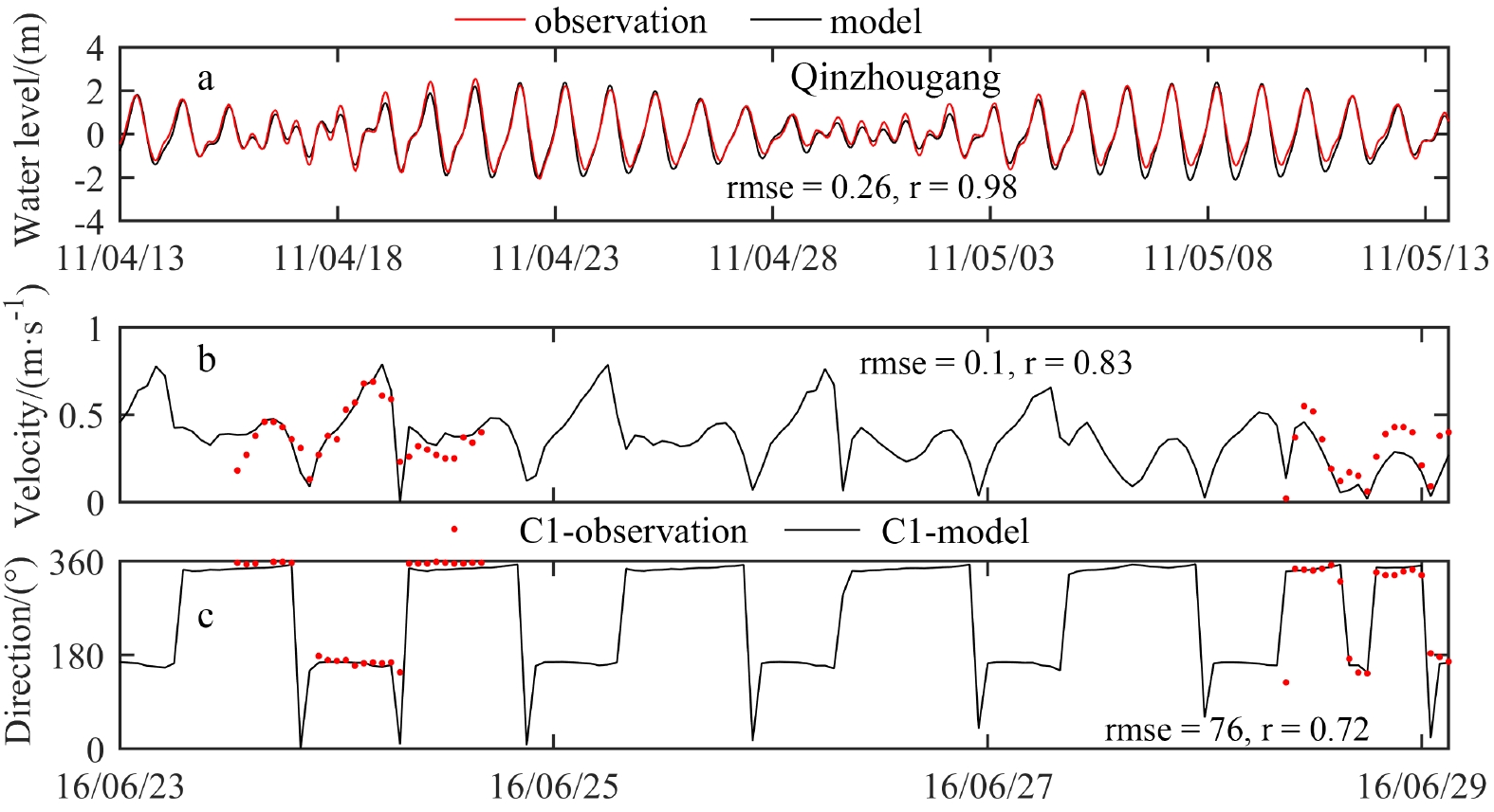
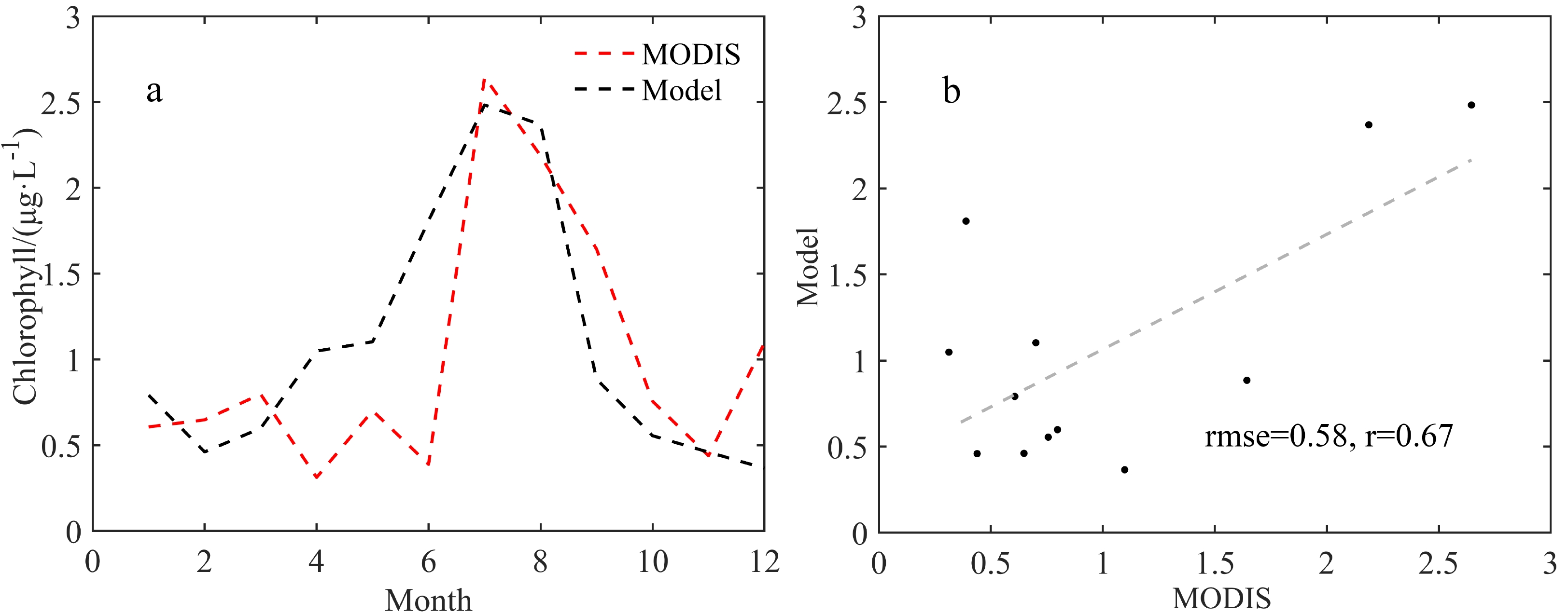
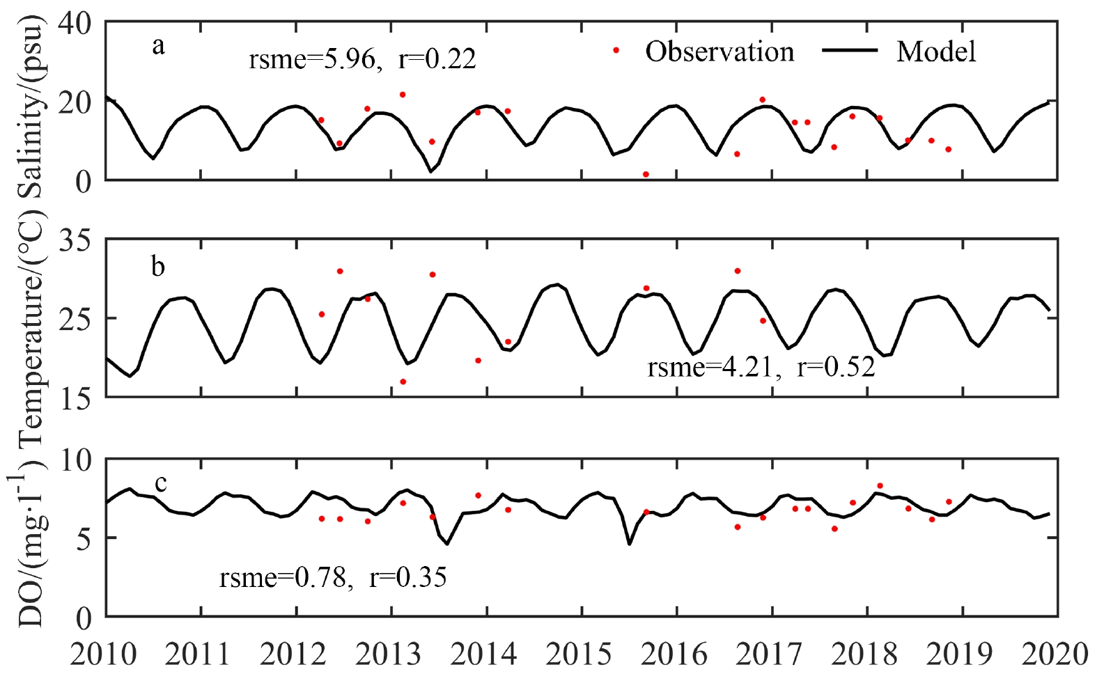
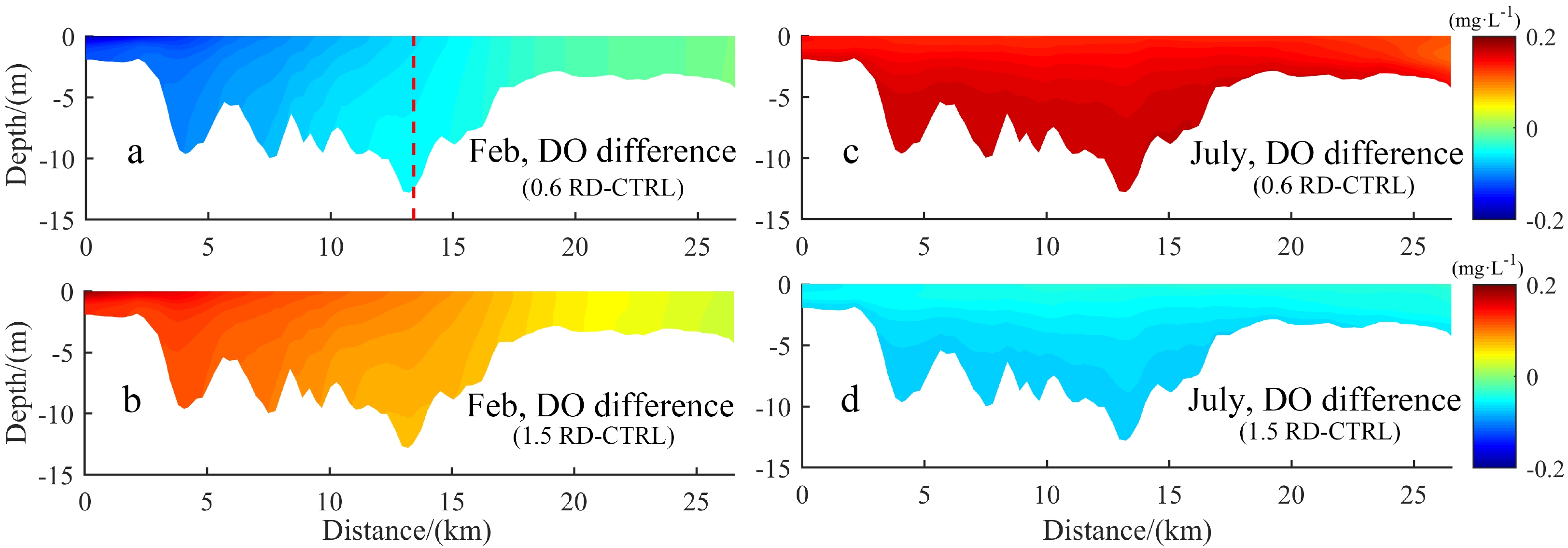
Oxygen facilitates the breakdown of the organic material to provide energy for life. The concentration of dissolved oxygen (DO) in the water must exceed a certain threshold to support the normal metabolism of marine organisms. Located in the northern Beibu Gulf, Qinzhou Bay receives abundant freshwater and nutrients from several rivers which significantly influence the level ofthe dissolved oxygen. However, the spatial-temporal variations of DO as well as the associated driving mechanisms have been rarely studiedstudied through field observations. In this study, a three-dimensional coupled physical-biogeochemical model is used to investigate the spatial and seasonal variations of the DO and the associated driving mechanisms in Qinzhou Bay. The validation against observations indicates that the model can capture the seasonal and inter-annual variability of the DO concentration with the range of 5−10 mg·L−1. Sensitivity experiments show that the river discharges, winds and tides play crucial roles in the seasonal variability of the DO by changing the vertical mixing and stratification of the water column and the circulation pattern. In winter, the tide and wind forces have strong effects on the DO distribution by enhancing the vertical mixing, especially near the bay mouth. In summer, the river discharges play a dominant role in the DO distribution by inhibiting the vertical water exchange and delivering more nutrients to the Bay, which increases the DO depletion and results in lower DO on the bottom of the estuary salt wedge. These findings can contribute to the preservation and management of the coastal environment in the northern Beibu Gulf.


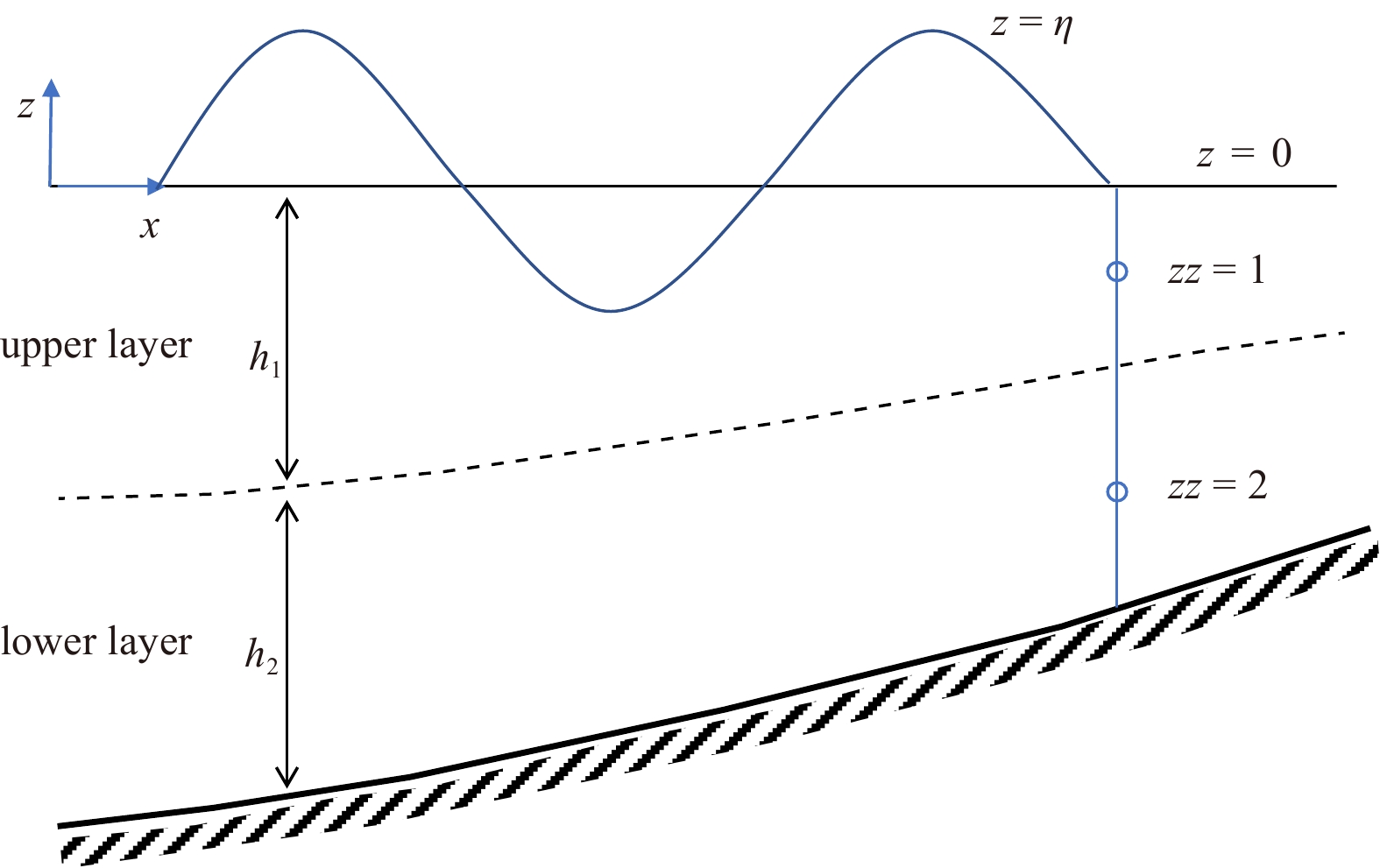
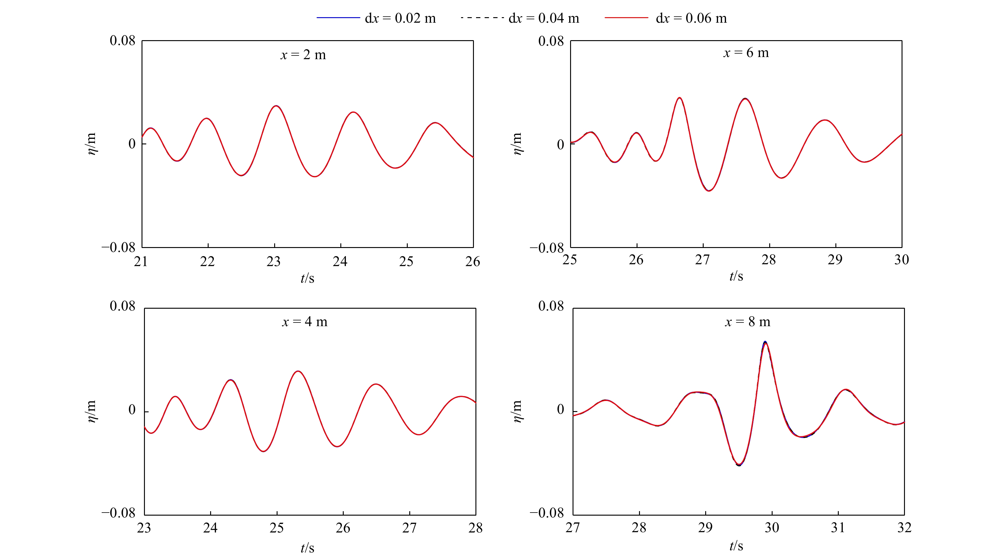
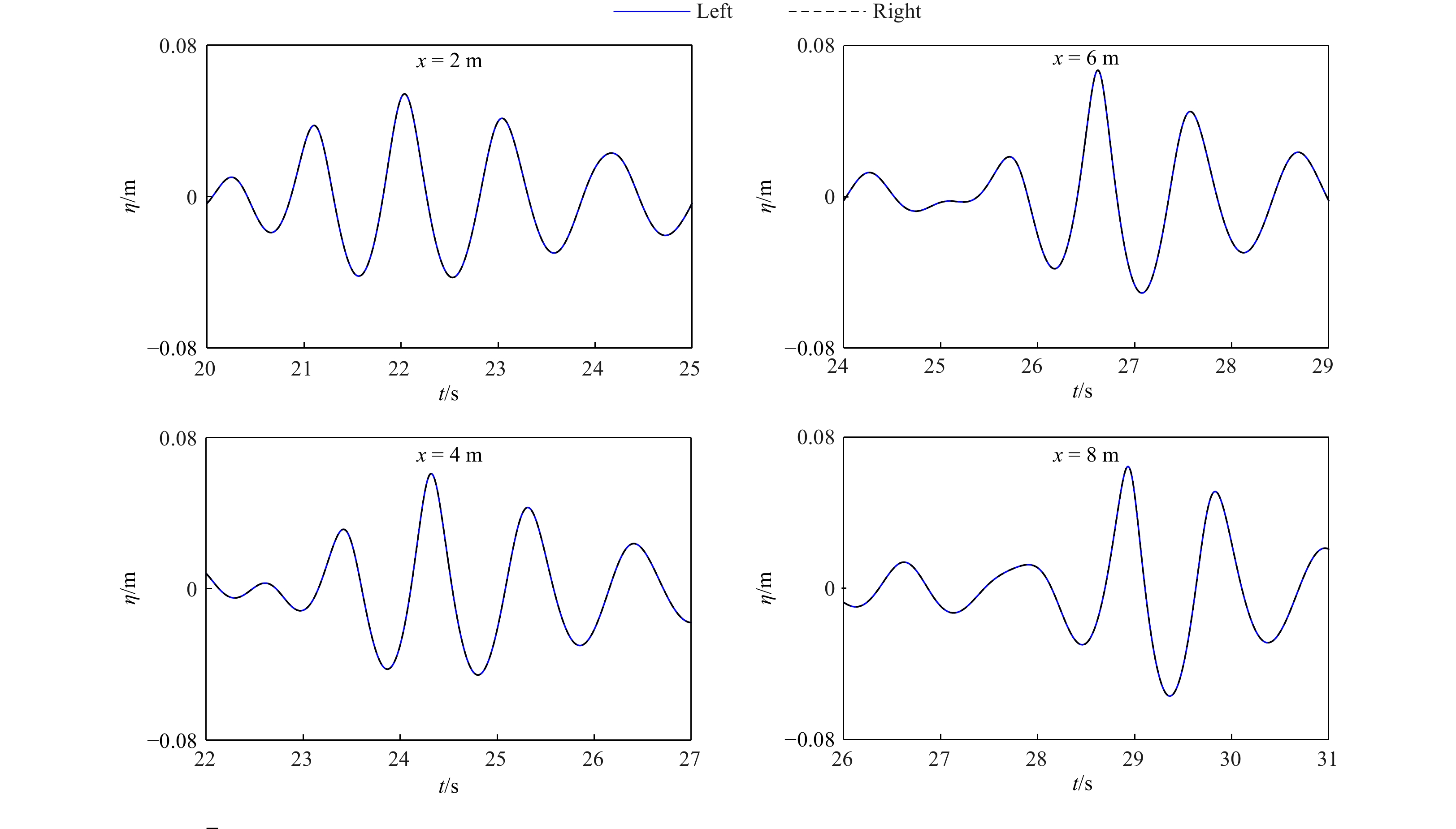
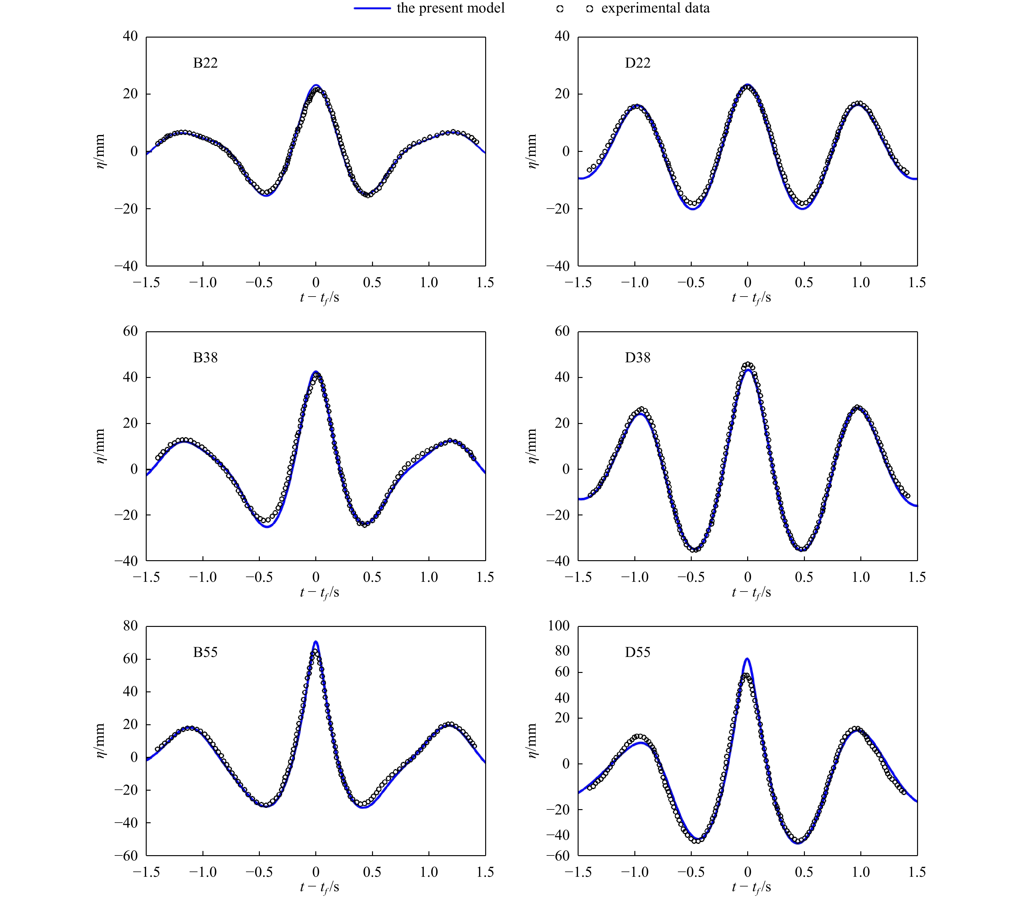
Accurate simulation of the evolution of freak waves by the wave phase focusing method requires accurate linear and nonlinear properties, especially in deep-water conditions. In this paper, we analyze the ability to simulate deep-water focused waves of a two-layer Boussinesq-type model, which has been shown to have excellent linear and nonlinear performance. To further improve the numerical accuracy and stability, the internal wave-generated method is introduced into the two-layer Boussinesq-type model. Firstly, the sensitivity of the numerical results to the grid resolution is analyzed to verify the convergence of the model; secondly, the focused wave propagating in two opposite directions is simulated to prove the symmetry of the numerical results and the feasibility of the internal wave-generated method; thirdly, the limiting focused wave condition is simulated to compare and analyze the wave surface and the horizontal velocity of the profile at the focusing position, which is in good agreement with the measured values. Meanwhile the simulation of focused waves in very deep waters agrees well with the measured values, which further demonstrates the capability of the two-layer BT model in simulating focused waves in deep waters.


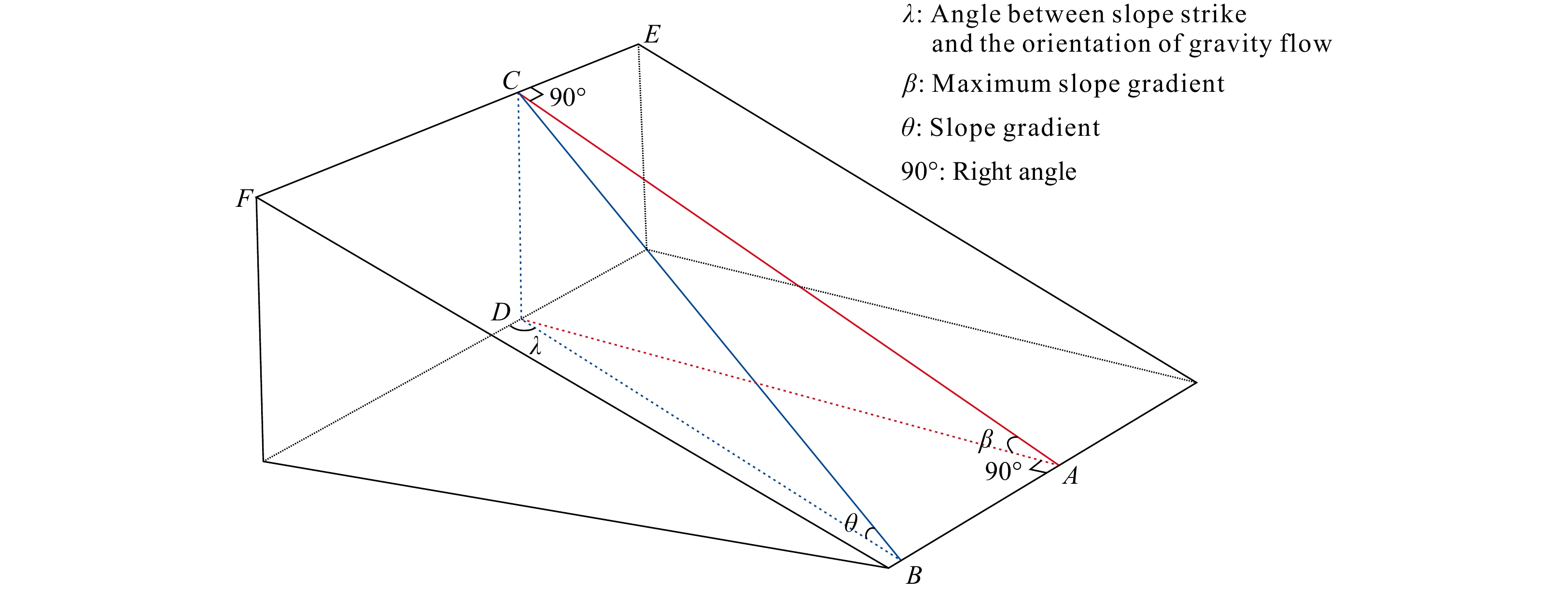
Deepwater oil and gas exploration is the key to sustainable breakthroughs in petroleum exploration worldwide. The Central Canyon gas field has confirmed the Lingshui Sag is a hydrocarbon-generating sag, and the deepwater reservoirs in the Lingshui Sag still have more fabulous oil and gas exploration potential. Based on drilling data and three-dimensional (3D) seismic data, this paper uses seismic facies analysis, seismic attribute analysis, and coherence slice analysis to identify the types of submarine fans (lobe-shaped and band-shaped submarine fans) that developed in the Lingshui Sag during the Middle Miocene, clarify the source-to-sink system of the submarine fans and discuss the genesis mechanism of the submarine fans. The results show that: (1) the deepwater source-to-sink system of the Lingshui Sag in the Middle Miocene mainly consisted of a “delta (sediment supply) - submarine canyon (sediment transport channel) - submarine fan (deepwater sediment sink)” association; (2) the main factor controlling the formation of the submarine fans developed in the Lingshui Sag was on the relative sea level decline; and (3) the bottom current reworked the lobe-shaped submarine fan that developed in the northern Lingshui Sag and formed the band-shaped submarine fan with a greater sand thickness. This paper aims to provide practical geological knowledge for subsequent petroleum exploration and development in the deepwater area of the Qiongdongnan Basin through a detailed analysis of the Middle Miocene submarine fan sedimentary system developed in the Lingshui Sag.


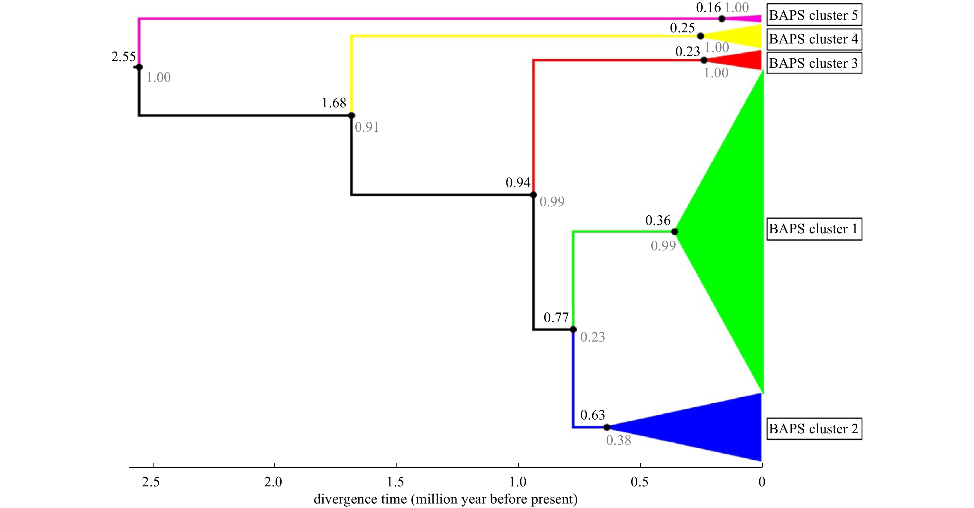
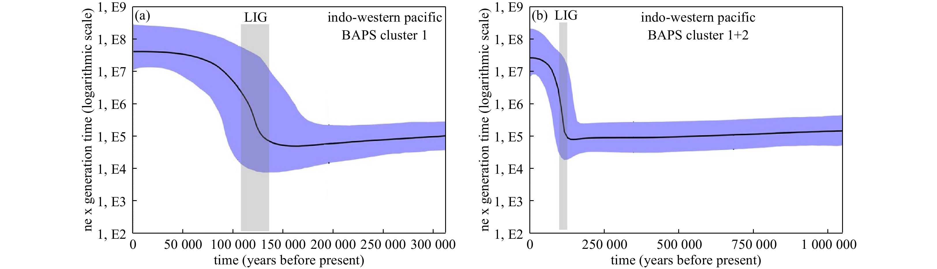
This study aims at identifying the microevolutionary processes responsible for the onset of the remarkable phylogeographic structure already recorded for the endangered giant clam Tridacna squamosa across its distribution range. For this purpose, the evolutionary, biogeographic and demographic histories of the species were comprehensively reconstructed in a mitochondrial dataset comprising nearly the whole available published cytochrome c oxidase 1 gene sequences of T. squamosa. Relatively higher level of genetic diversification was unveiled within T. squamosa, in comparison to earlier macro-geographic investigations, whereby five mitochondrial clusters were delineated. The resulting divergent gene pools in the Red Sea, Western Indian Ocean, Indo-Malay Archipelago and Western Pacific were found to be driven by Early Pleistocene glacial vicariance events among refugial lineages. Accentuated genetic diversification of the species across the Indo-Malay Archipelago was successively triggered by historical dispersal event during the Mid-Pleistocene MIS19c interglacial. This latter historical event might have also enabled genetically distinct giant clams from the Indo-Malay Archipelago to subsequently colonize the Western Pacific, accounting for the genetic diversity hotspot detected within this region (comprising three divergent mitochondrial clusters). Late Pleistocene demographic expansion of T. squamosa, during the Last Interglacial period, could have contributed to forging spatial distribution of the so far delineated genetic entities across the Indo-Western Pacific. Overall, being resilient to major climate shifts during the Pleistocene through adaptation and consequent diversification, T. squamosa could be used as a model species to track the impact of climate change on genetic variability and structure of marine species. In particular, the new information, provided in this investigation, may help with understanding and/or predicting the consequences of ongoing global warming on genetic polymorphism of endangered coral reef species among which Tridacna sp. are listed as ecologically important.


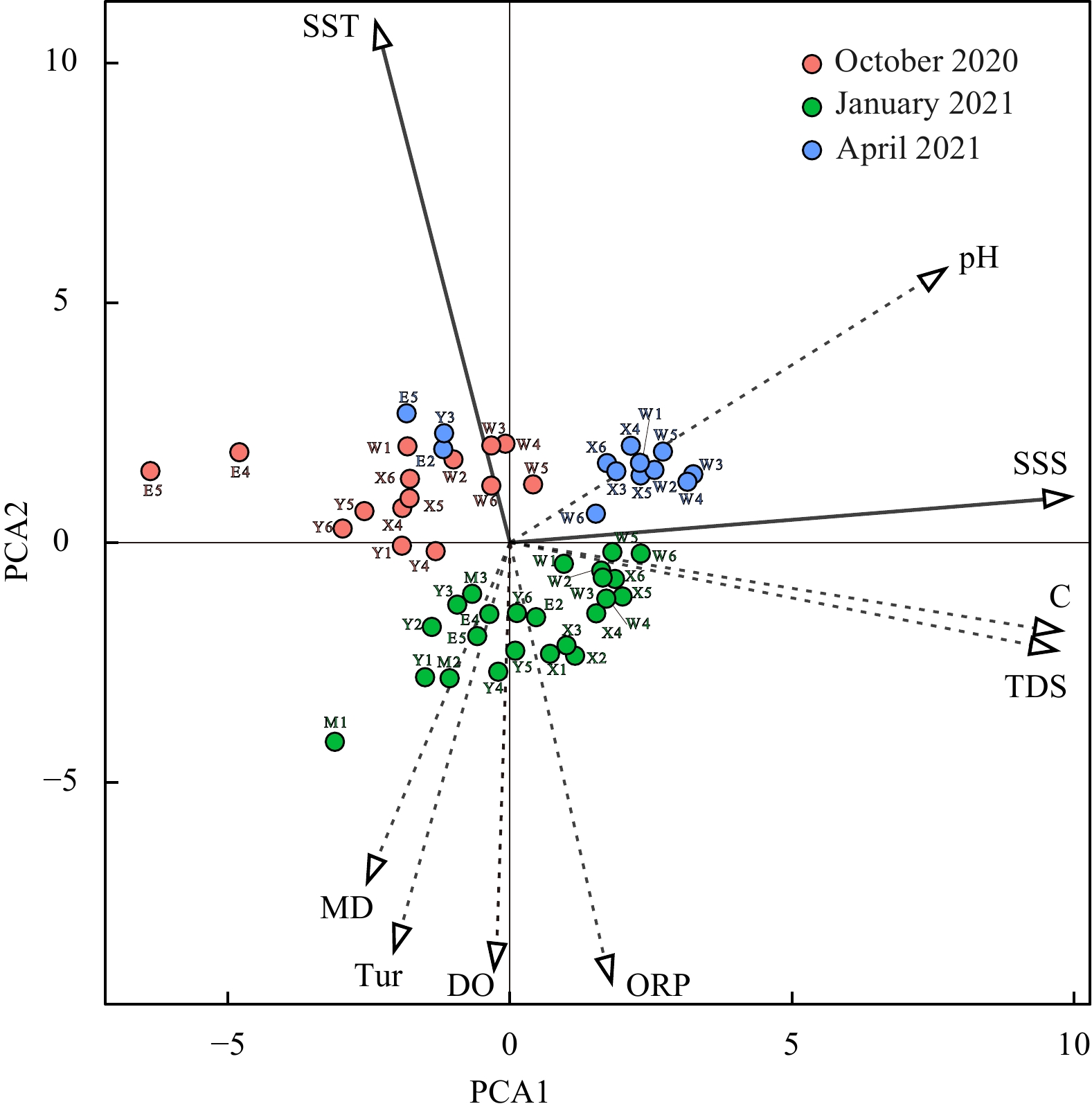
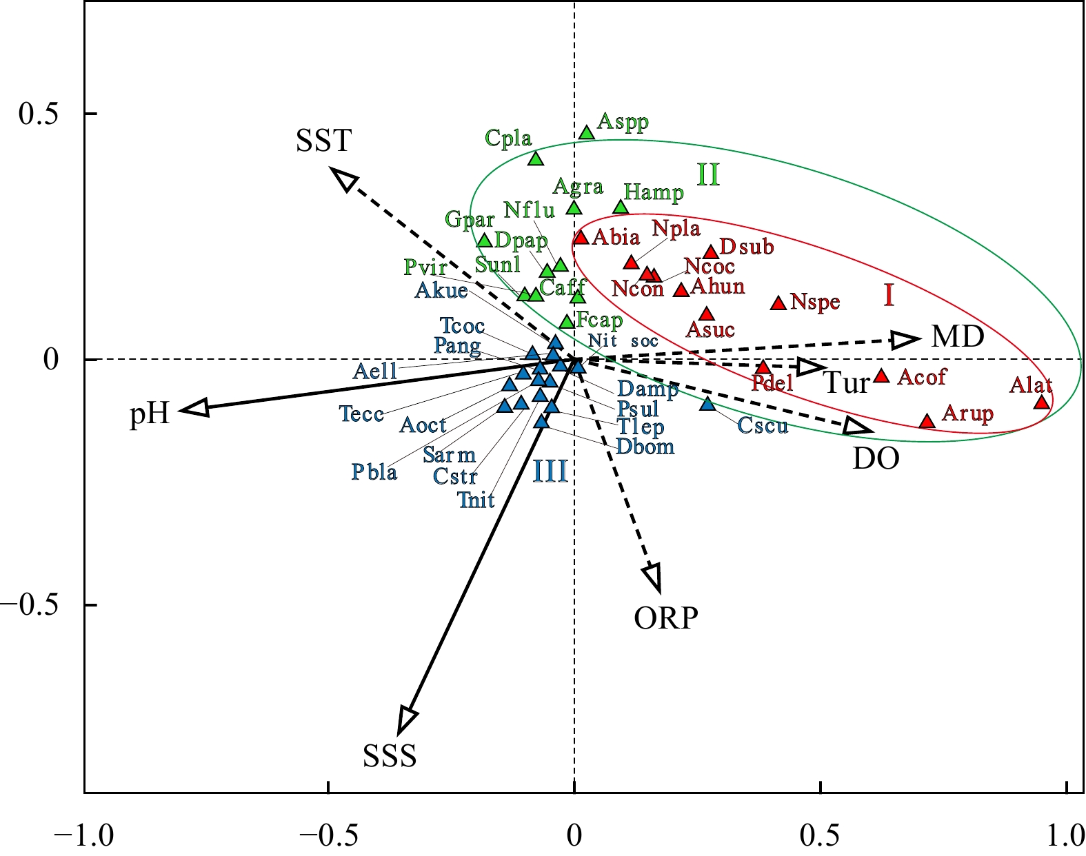
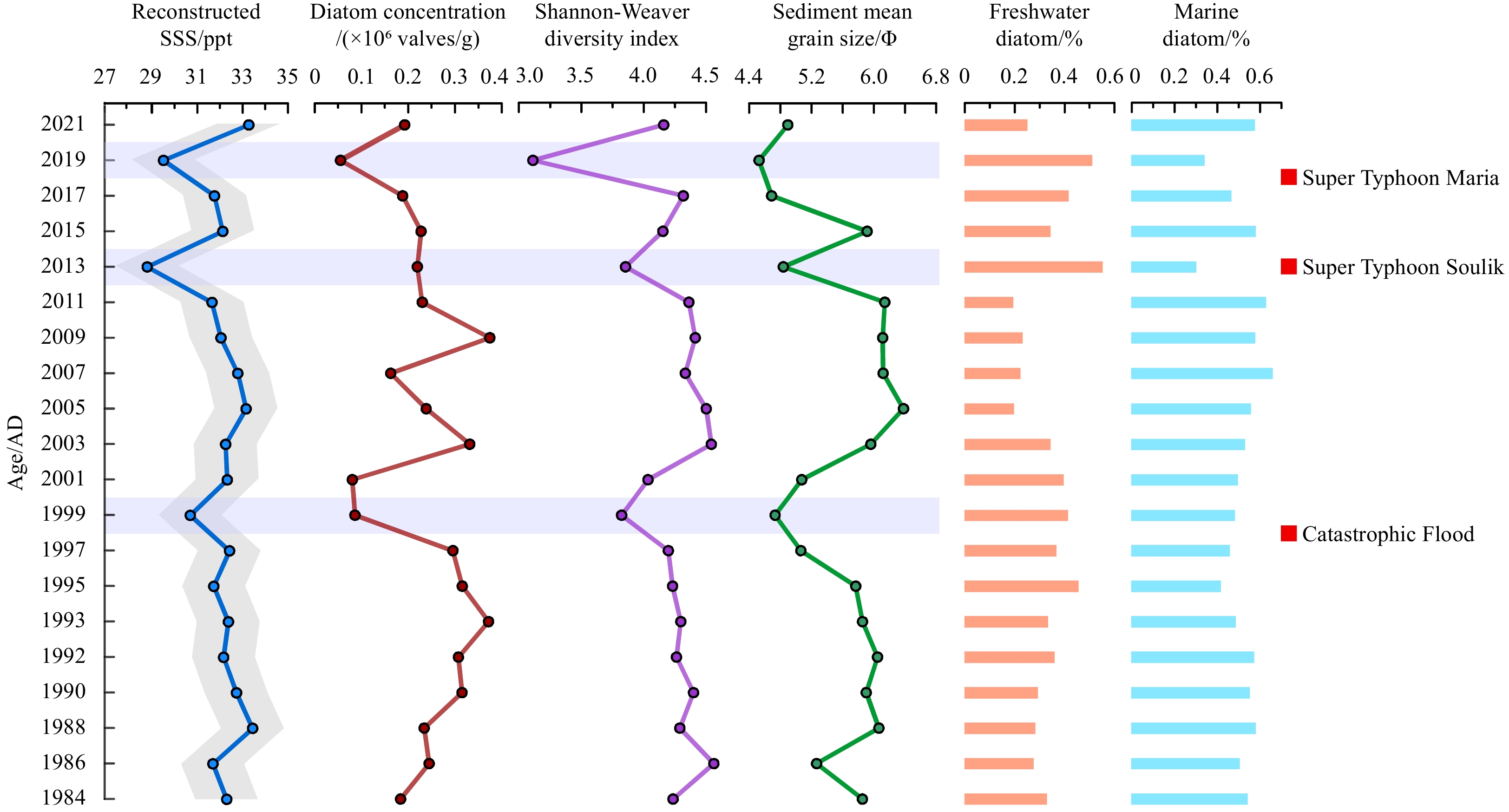
Owing to the significant differences in environmental characteristics and explanatory factors among estuarine and coastal regions, research on diatom transfer functions and database establishment remains incomplete. This study analysed diatoms in surface sediment samples and a sediment core from the Lianjiang coast of the East China Sea, together with environmental variables. Principal component analysis of the environmental variables showed that sea surface salinity (SSS) and sea surface temperature were the most important factors controlling hydrological conditions in the Lianjiang coastal area, whereas canonical correspondence analysis indicated that SSS and pH were the main environmental factors affecting diatom distribution. Based on the modern diatom species–environmental variable database, we developed a diatom-based SSS transfer function to quantitatively reconstruct the variability in SSS between 1984 and 2021 for sediment core HK3 from the Lianjiang coastal area. The agreement between the reconstructed SSS and instrument SSS data from 1984–2021 suggests that diatom-based SSS reconstruction is reliable for studying past SSS variability in the Lianjiang coastal area. Three low SSS events in AD 2019, 2013, and 1999, together with an increased relative concentration of freshwater diatom species and coarser sediment grain sizes, corresponded to two super-typhoon events and a catastrophic flooding event in Lianjiang County. Thus, a diatom-based SSS transfer function for reconstructing past SSS variability in the estuarine and coastal areas of the East China Sea can be further used to reflect the paleoenvironmental events in this region.


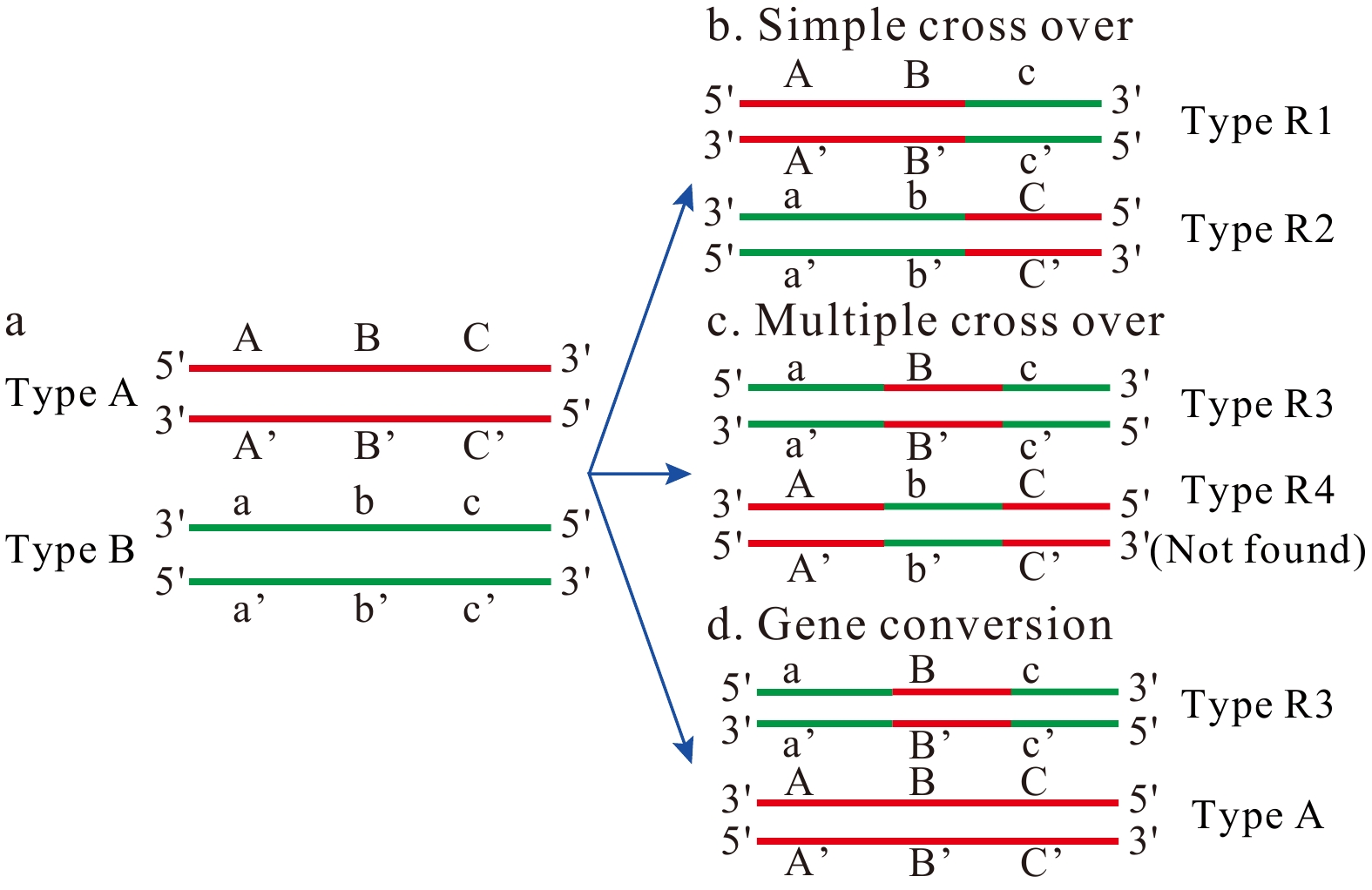
The conventional theory of concerted evolution has been used to explain the lack of sequence variation in ribosomal RNA (rRNA) genes across diverse eukaryotic species. However, recent investigations into rRNA genes in flatfish genome have resulted in controversial findings. This study focuses on 18S rRNA genes of the widely distributed tongue sole, Cynoglossus abbreviatus (Pleuronectiformes: Cynoglossidae), aiming to explore sequence polymorphism. Five distinct 18S rDNA sequence types (Type A, B, R1, R2, and R3) were identified, suggesting a departure from concerted evolution. A combination of general criteria and variations in highly conserved regions were employed to detect pseudogenes. The results pinpointed Type A sequences as potential pseudogenes due to significant sequence variations and deviations in secondary structure within highly conserved regions. Three types (Type R1, R2, and R3) were identified as recombinants between Type A and B sequences, with simple crossing over and gene conversion as the most likely recombination mechanisms. These findings not only contribute to rRNA pseudogene identification but also shed light on the evolutionary dynamics of rRNA genes in teleost genomes.


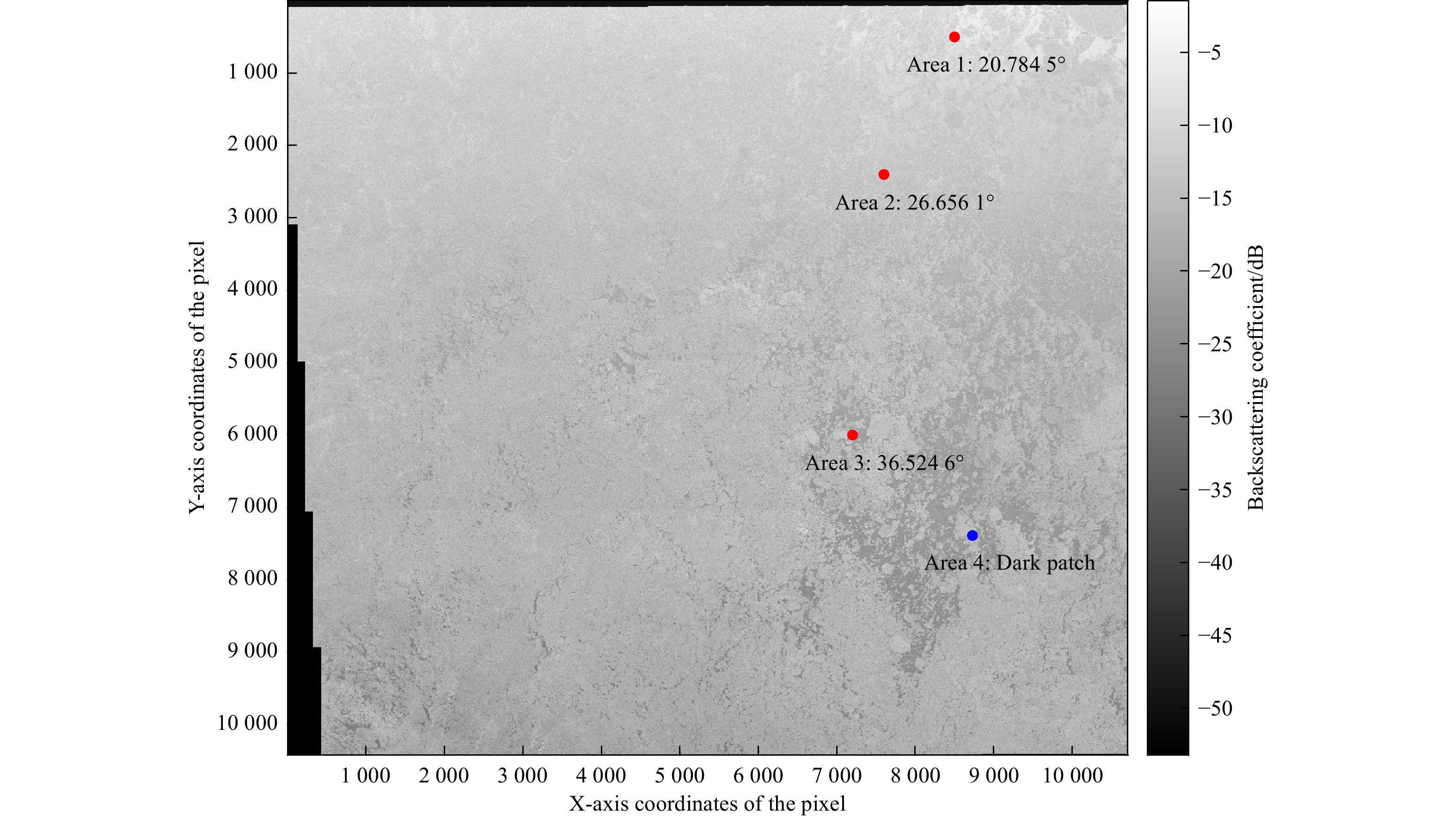
To protect the sustainability of the benefits from seas and near coastal areas, which have under the effect of the very complex hydrodynamic conditions and intensive human activities, without disrupting the balance of nature, it is necessary to image the status of the seafloor features. Therefore, this study presents the deformations, depositional conditions, underwater constructions, and the other non-natural impacts on the seafloor of the nearshore area at western Istanbul (between Küçükçekmece and Büyükçekmece Lagoons) where it intensely used by the citizens. The results of the study may provide some guidance for understanding the impacts and risk factors of uses that are or will be conducted in coastal and/or near-coastal areas. Construction planning for civil coastal structures and areas should be done in great harmony with nature, minimizing negative environmental impacts. Although sediment distribution in the area is generally quite complex, the current state of the region, wave action, hydrodynamic conditions, the amount of material transported from the land, and bathymetry are important influencing factors. The seafloor has been damaged primarily by anchor deformation and associated bottom scanning, as well as disturbing trawl tracks. The seafloor was observed as partially shallowing near the constructions (such as natural gas pipelines, fishermen's shelter, and port piles) of coastal areas and associated with sand deposits. Therefore, scanning the seafloor using side-scan sonar may provide valuable frequency data to prevent future disruptions.


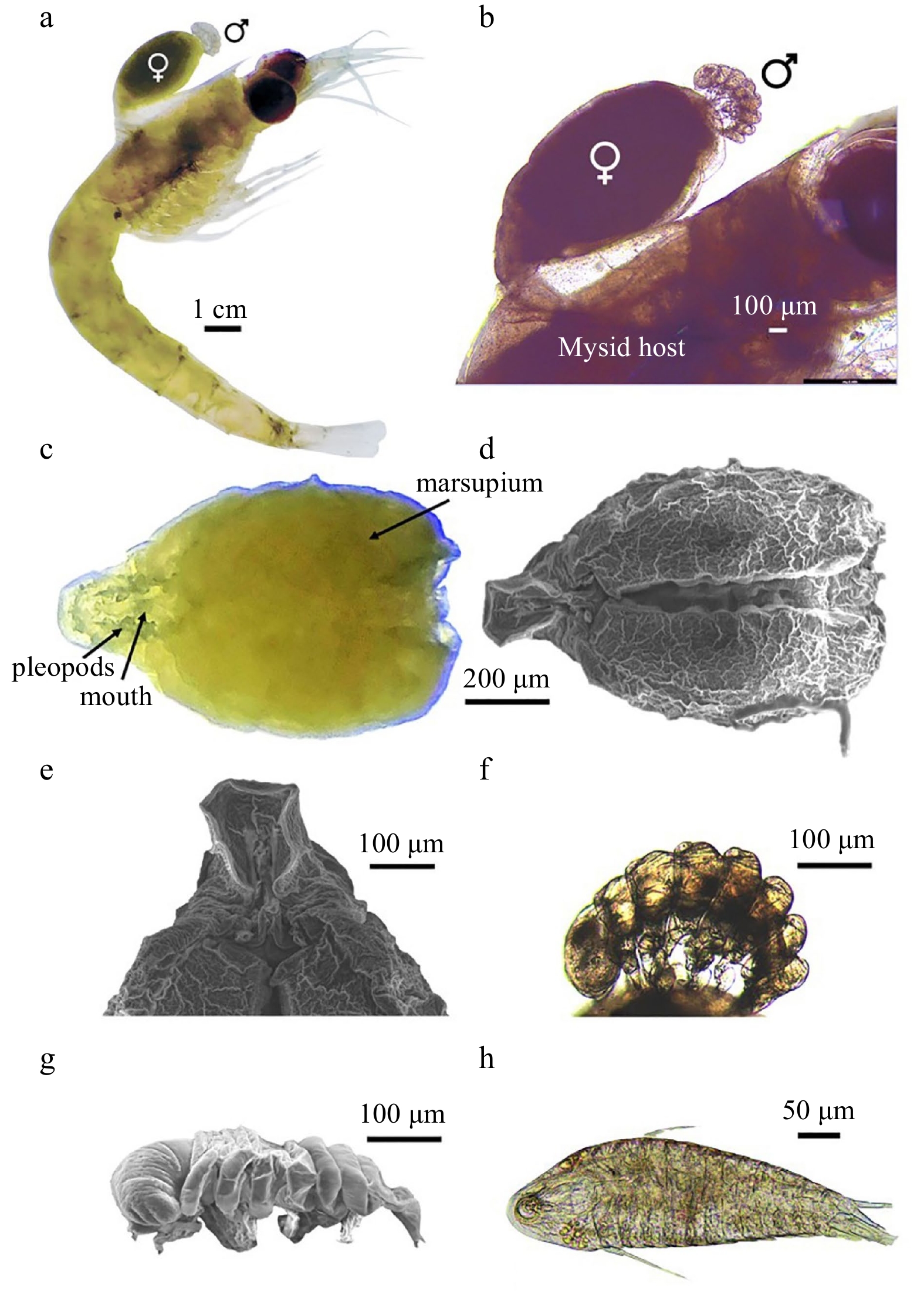
Isopod crustaceans of the family Dajidae are exclusively marine ectoparasites. The genus Notophryxus


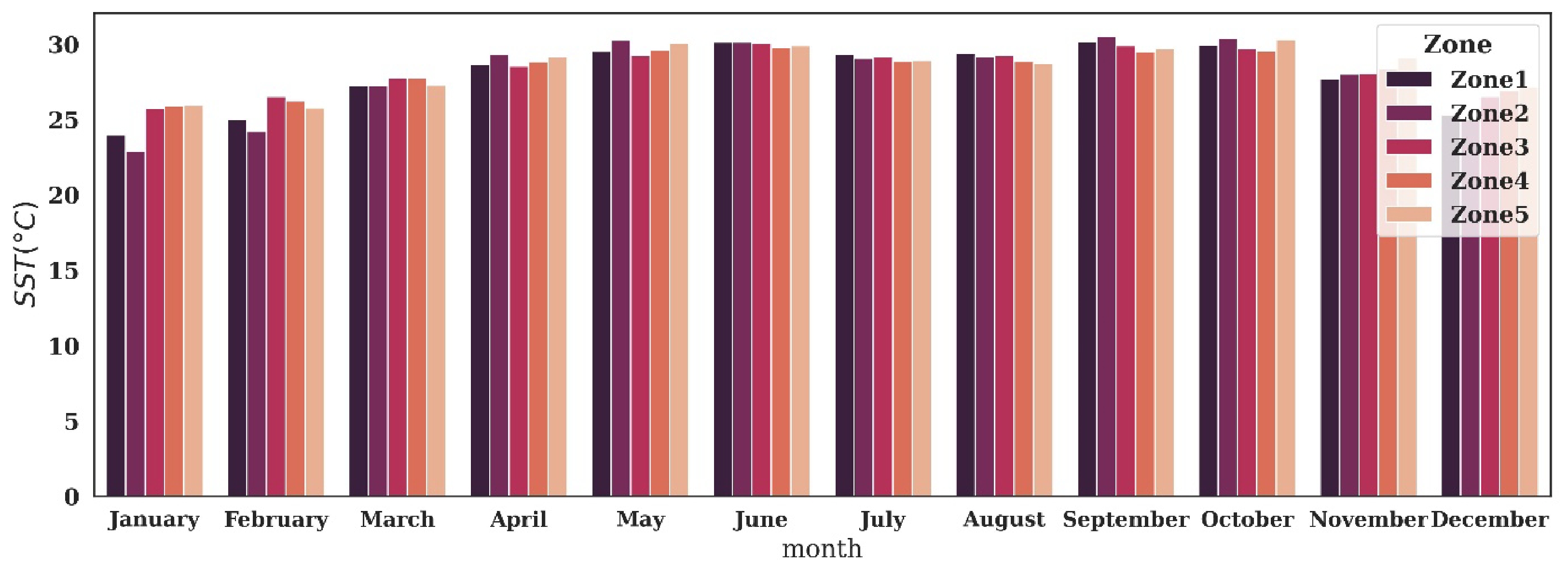
Ocean productivity is the foundation of the marine food web, which continuously removes atmospheric carbon dioxide and supports life at sea and on land. Spatio-temporal variability of net primary productivity (NPP), sea surface temperature (SST), sea surface salinity (SSS), mixed layer depth (MLD), and euphotic zone depth (EZD) in the northern Bay of Bengal (BoB) during the three monsoon seasons were examined in this study based on remote sensing data for the period 2005 to 2020. To compare the NPP distribution between the coastal zones and open BoB, the study area was divided into five zones (Z1-Z5). The results suggest that the most productive Z2 and Z1 are located at the head bay area and are directly influenced by freshwater discharge together with riverine sediment and nutrient loads. Across Z1-Z5, the NPP ranges from 5315.38 mg/(m2·d) to 346.7 mg/(m2·d) (in terms of carbon, since then the same). The highest monthly average NPP of 5315.38 mg/(m2·d) in February and 5039.36 mg/(m2·d) in June were observed from Z2, while the lowest monthly average of 346.72 mg/(m2·d) was observed in March from Z4, which is an oceanic zone. EZD values vary from 6-154 m for the study area, and it has an inverse correlation with NPP concentration. EZD is deeper during the summer season and shallower during the wintertime, with a corresponding increase in productivity. Throughout the year, monthly SST shows slight fluctuation for the entire study area, and statistical analysis showed a significant correlation among NPP, and EZD, overall positive between NPP and MLD, whereas no significant correlation among SSS, and SST for the northern Bay of Bengal. Long-term trends in SST and productivity were significantly positive in head bay zones but negatively productive in the open ocean. The findings in this study on the distribution of NPP, SST, SSS, MLD, and EZD and their seasonal variability in five different zones of BoB can be used to further improve the management of marine resources and overall environmental conditional in response to climate changes in the BoB as they are of utmost relevance to the fisheries for the three bordering countries.


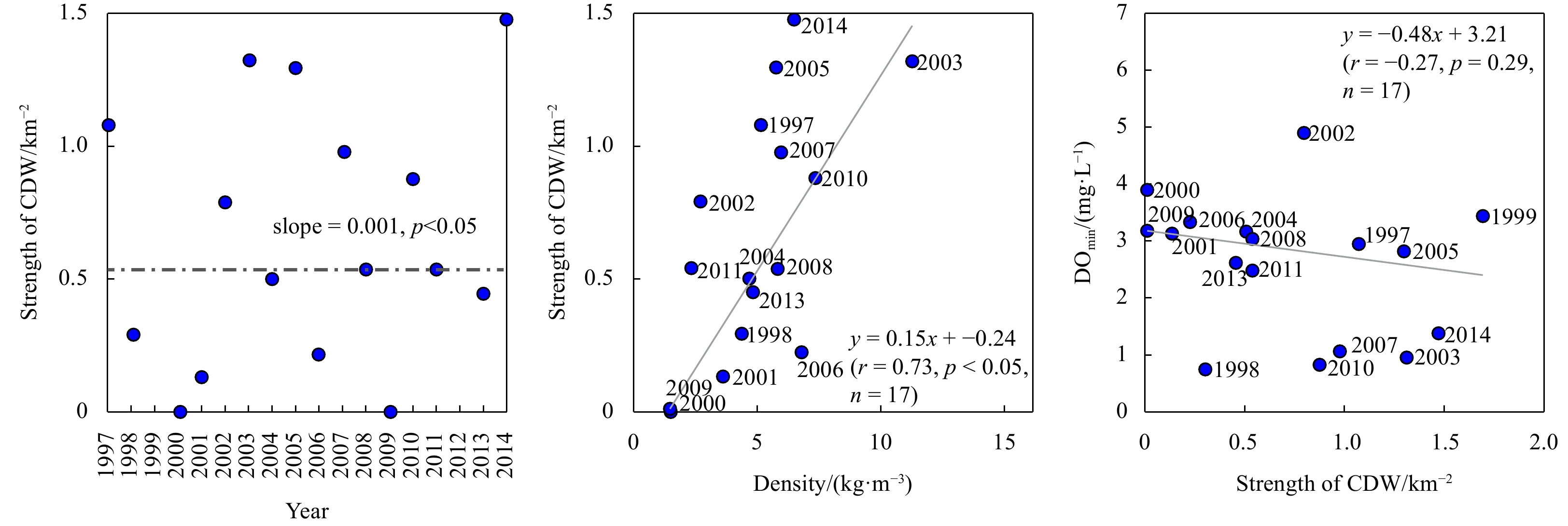
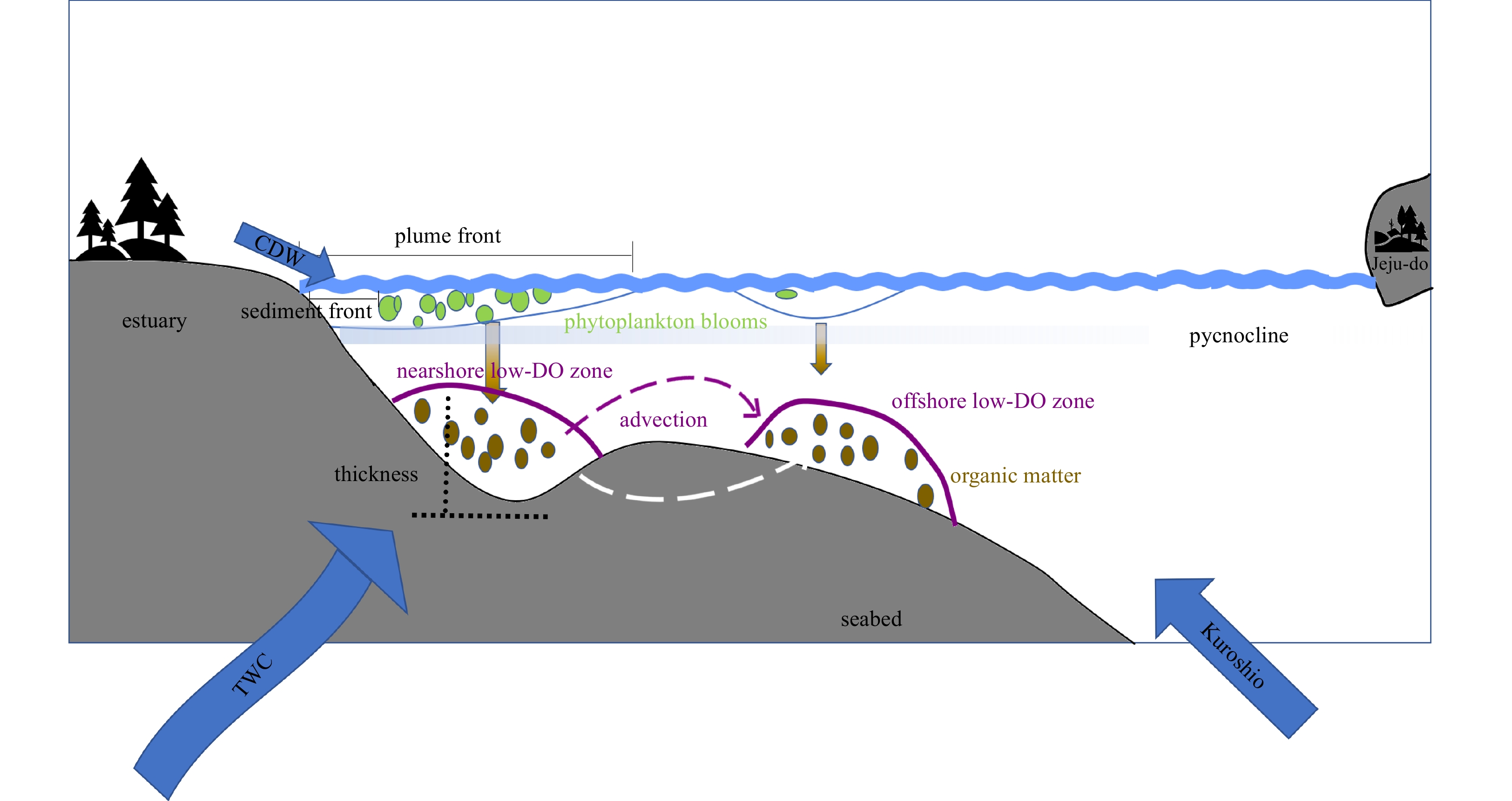
Hypoxia off the Changjiang River Estuary has been the subject of much attention, yet systematic observations have been lacking, resulting in a lack of knowledge regarding its long-term change and drivers. By revisiting the repeated surveys of dissolved oxygen (DO) and other relevant hydrographic parameters along the section from the Changjiang River Estuary to the Cheju Island in the summer from 1997 to 2014, rather different trends were revealed for the dual low-DO cores. The nearshore low-DO core, located close to the river mouth and relatively stable, shows that hypoxia has become more severe with the lowest DO descending at a rate of −0.07 mg/(L·a) and the thickness of low-DO zone rising at a rate of 0.43 m/a. The offshore core, centered around 40-m isobath but moving back and forth between 123.5°–125°E, shows large fluctuations in the minimum DO concentration, with the thickness of low-DO zone falling at a rate of −1.55 m/a. The probable factors affecting the minimum DO concentration in the two regions also vary. In the nearshore region, the decreasing minimum DO is driven by the increase in both stratification and primary productivity, with the enhanced extension of the Changjiang River Diluted Water (CDW) strengthening stratification. In the offshore region, the fluctuating trend of the minimum DO concentration indicates that both DO loss and DO supplement are distinct. The DO loss is primarily attributed to bottom apparent oxygen utilization caused by the organic matter decay and is also relevant to the advection of low-DO water from the nearshore region. The DO supplement is primarily due to weakened stratification. Our analysis also shows that the minimum DO concentration in the nearshore region was extremely low in 1998, 2003, 2007 and 2010, related to El Niño signal in these summers.


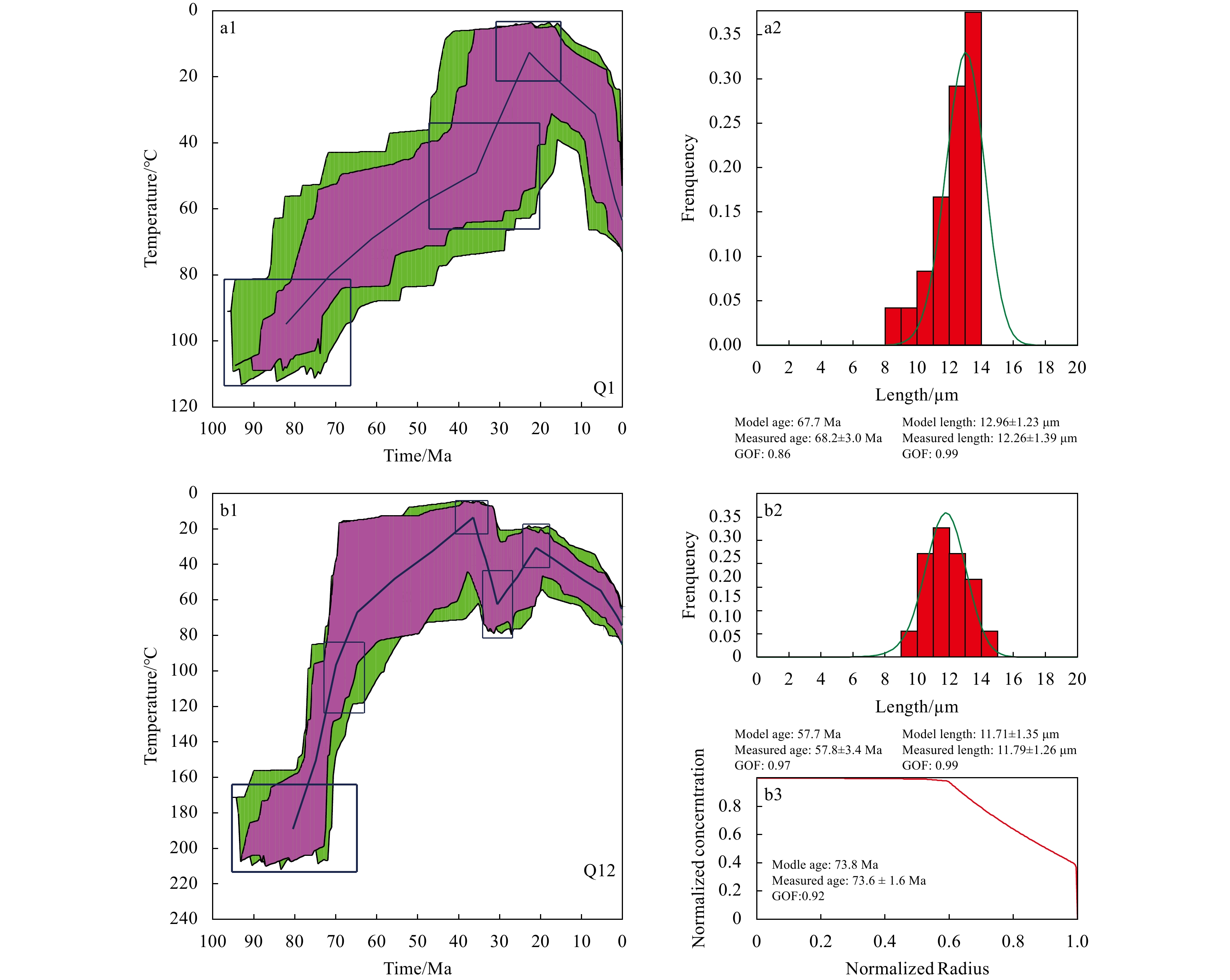
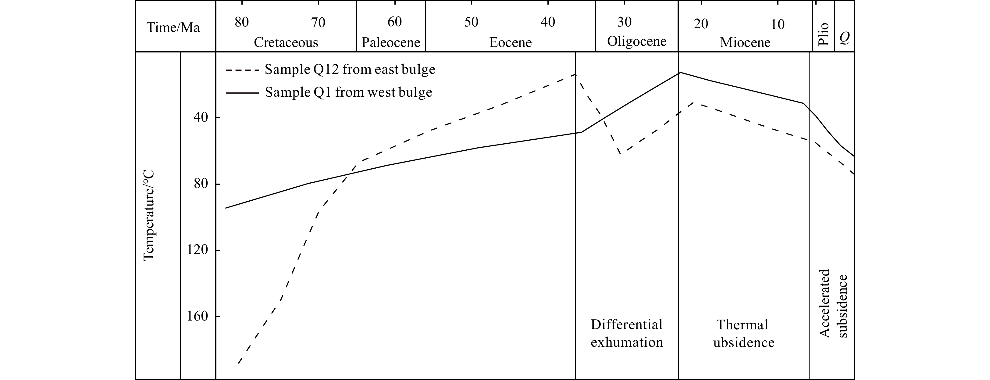
Significant advancements have been made in the study of Mesozoic granite buried hills in the Songnan Low Uplift (SNLU) of the Qiongdongnan Basin. These findings indicate that the bedrock buried hills in this basin hold great potential for exploration. Borehole samples taken from the granite buried hills in the SNLU were analyzed using apatite fission track (AFT) and zircon (U-Th)/He data to unravel the thermal history of the basement rock. This information is crucial for understanding the processes of exhumation and alteration that occurred after its formation. Thermal modeling of a sample from the western bulge of the SNLU revealed a prolonged cooling event from the late Mesozoic to the Oligocene period (~80−23.8 Ma), followed by a heating stage from the Miocene epoch until the present (~23.8 Ma to present). In contrast, the sample from the eastern bulge experienced a more complex thermal history. It underwent two cooling stages during the late Mesozoic to late Eocene period (~80−36.4 Ma) and the late Oligocene period (~30−23.8 Ma), interspersed with two heating phases during the late Eocene to early Oligocene period (~36.4−30 Ma) and the Miocene epoch to recent times (~23.8−0 Ma), respectively. The differences in exhumation histories between the western and eastern bulges during the late Eocene to Oligocene period in the SNLU can likely be attributed to differences in fault activity. Unlike typical passive continental margin basins, the SNLU has experienced accelerated subsidence after the rifting phase, which began around 5.2 Ma ago. The possible mechanism for this abnormal post-rifting subsidence may be the decay or movement of the deep thermal source and the rapid cooling of the asthenosphere. Long-term and multi-episodic cooling and exhumation processes play a key role in the alteration of bedrock and contribute to the formation of reservoirs. On the other hand, rapid post-rifting subsidence (sedimentation) promotes the formation of cap rocks.


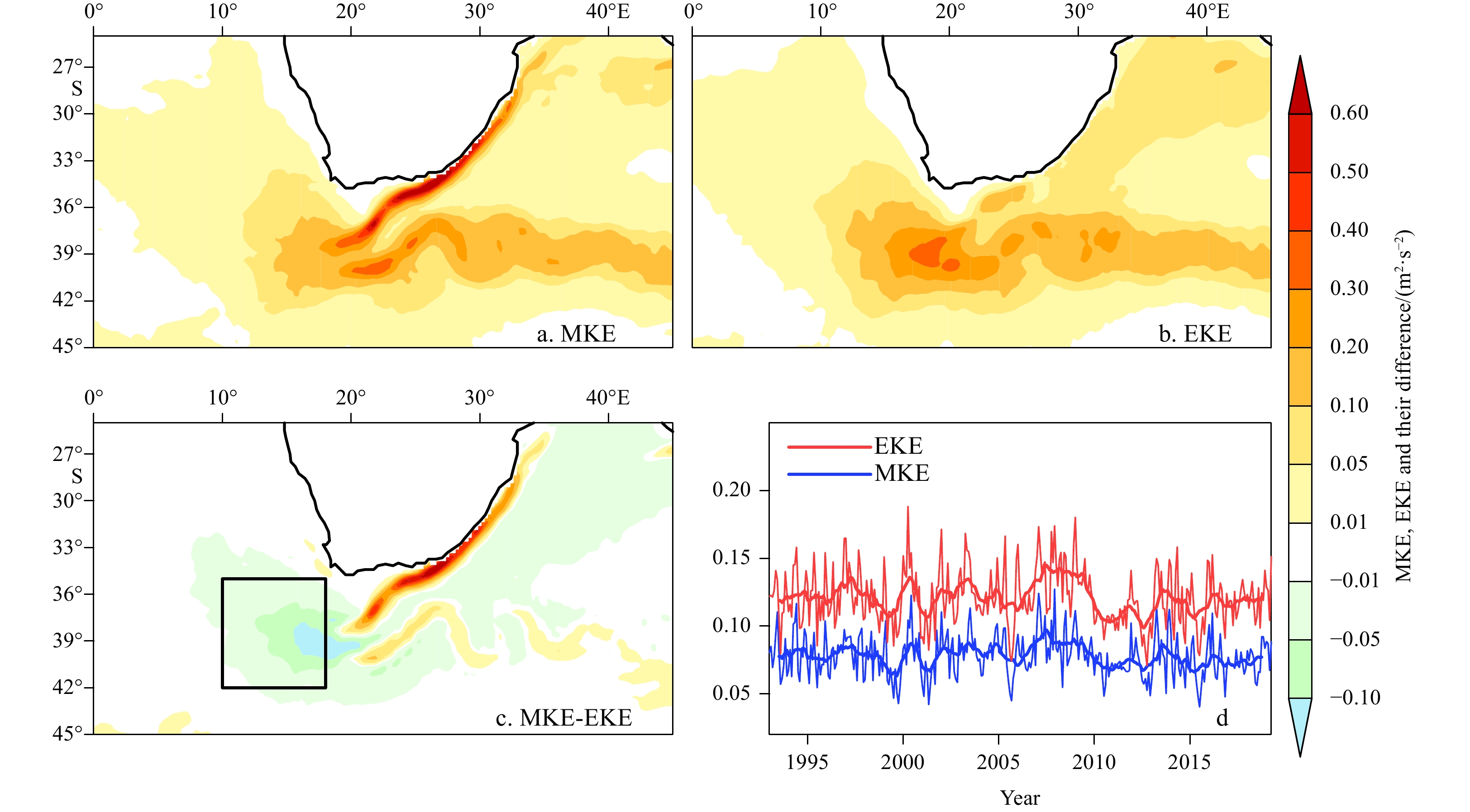
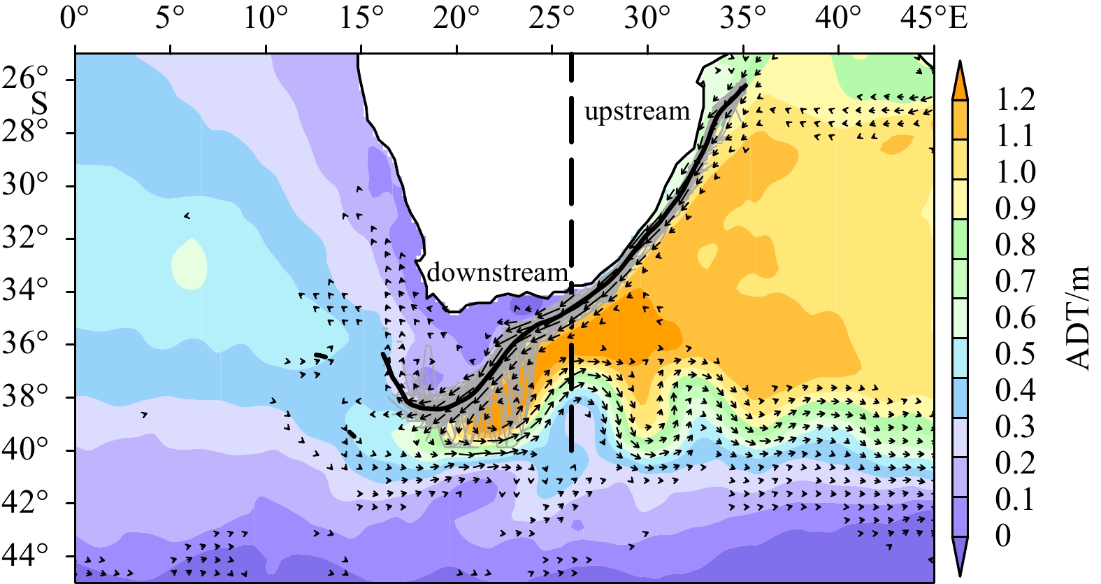
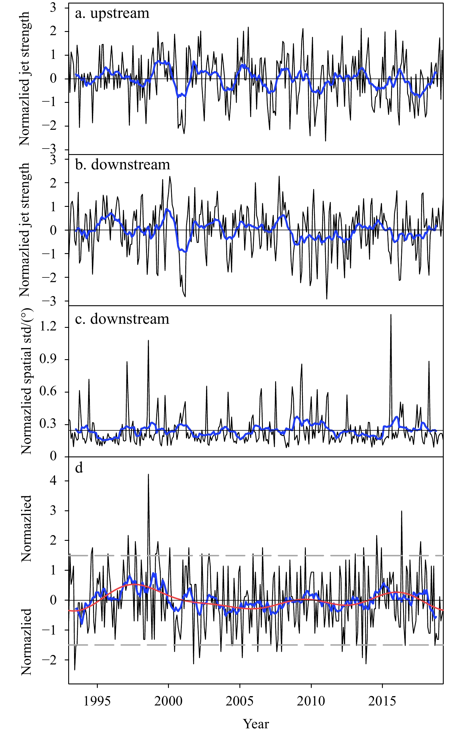
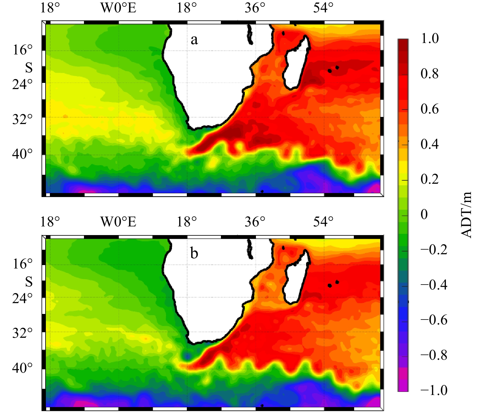
The Agulhas system is the strongest western boundary current system in the Southern Hemisphere and plays an important role in modulating the Indian-to-Atlantic Ocean water exchange by the Agulhas leakage. It is difficult to measure in situ transport of the Agulhas leakage as well as the Agulhas retroflection position due to their intermittent nature. In this study, an innovative kinematic algorithm is designed and applied to the gridded altimeter observational data, to ascertain the longitudinal position of Agulhas retroflection, the stability of Agulhas jet stream, as well as its strength. The results show that the east-west shift of retroflection is related neither to the strength of Agulhas current nor to its stability. Further analysis uncovers the connection between the westward extension of Agulhas jet stream and an anomalous cyclonic circulation at its northern side, which is likely attributed to the local wind stress curl anomaly. To confirm the effect of local wind forcing on the east-west shift of retroflection, numerical sensitivity experiments are conducted. The results show that the local wind stress can induce a similar longitudinal shift of the retroflection as altimetry observations. Further statistical and case study indicates that whether an Agulhas ring can continuously migrate westward to the Atlantic Ocean or re-merge into the main flow depends on the retroflection position. Therefore, the westward retroflection may contribute to a stronger Agulhas leakage than the eastward retroflection.


The spaceborne platform has unprecedently provided the global eddy-permitting (typically ~0.25°) products of Sea Surface Salinity (SSS), however the existing SSS products can hardly resolve mesoscale motions due to the heavy noises therein and the over-smoothing in denoising processes. By means of the Multi-fractal Fusion (MFF), the high-resolution SSS product is synthesized with the template of Sea Surface Temperature (SST). Two low-resolution SSS products and four SST products are considered as the source data and the templates respectively to determine the best combination. The fused products are validated by the in situ observations and intercompared via SSS maps, Singularity Exponent maps and wavenumber spectra. The results demonstrate that the MFF can perform a good work in mitigating the noises and improving the resolution. The Climate Change Initiative (CCI) SSS + the REMote Sensing System (REMSS) SST can produce the 0.1° denoised product whose global mean STandard Derivation (STD) against Argo is 0.21 psu and the feature resolution can reach 30-40 km.


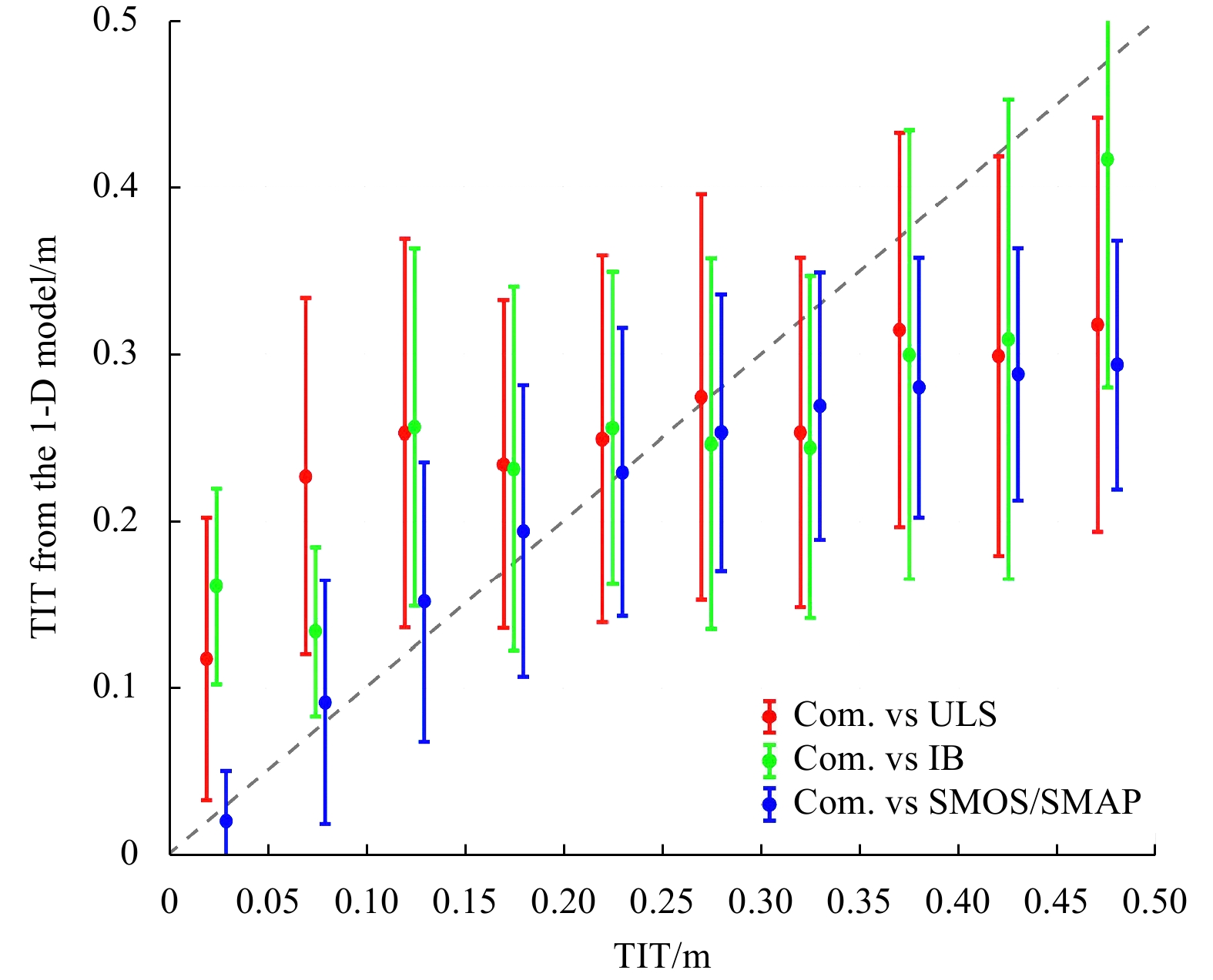
Retrieval of thin-ice thickness (TIT) using thermodynamic modeling is sensitive to the parameterization of the independent variables (coded in the model) and the uncertainty of the measured input variables. This article examines the deviation of the classical model’s TIT output when using different parameterization schemes and the sensitivity of the output to the ice thickness. Moreover, it estimates the uncertainty of the output in response to the uncertainties of the input variables. The parameterized independent variables include atmospheric longwave emissivity, air density, specific heat of air, latent heat of ice, conductivity of ice, snow depth, and snow conductivity. Measured input parameters include air temperature, ice surface temperature, and wind speed. Among the independent variables, the results show that the highest deviation is caused by adjusting the parameterization of snow conductivity and depth, followed ice conductivity. The sensitivity of the output TIT to ice thickness is highest when using parameterization of ice conductivity, atmospheric emissivity, and snow conductivity and depth. The retrieved TIT obtained using each parameterization scheme is validated using in situ measurements and satellite-retrieved data. From in situ measurements, the uncertainties of the measured air temperature and surface temperature are found to be high. The resulting uncertainties of TIT are evaluated using perturbations of the input data selected based on the probability distribution of the measurement error. The results show that the overall uncertainty of TIT to air temperature, surface temperature, and wind speed uncertainty is around 0.09 m, 0.049 m, and −0.005 m, respectively.


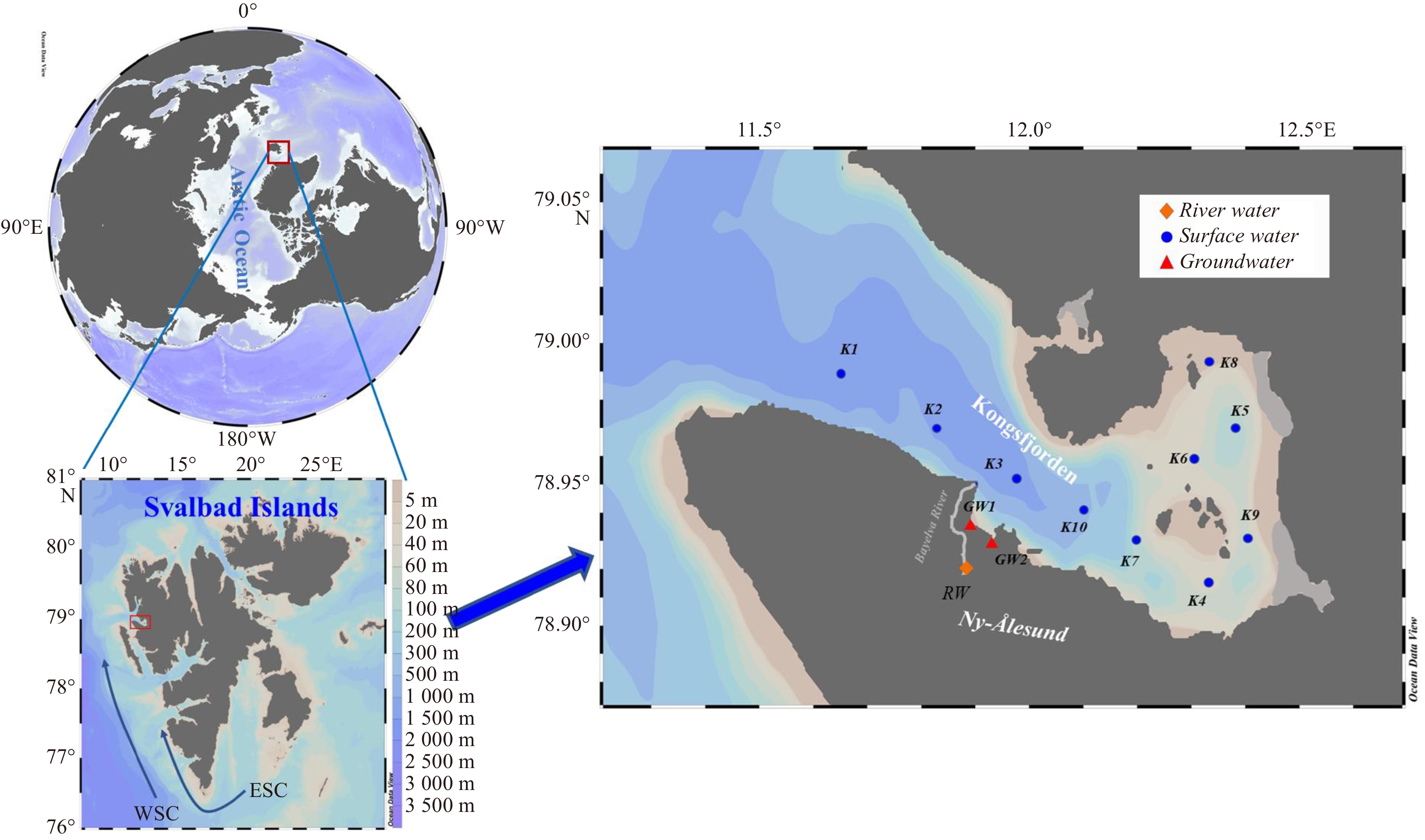
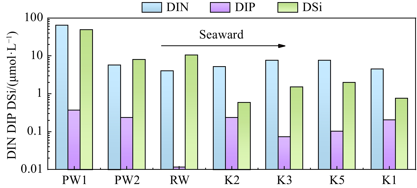
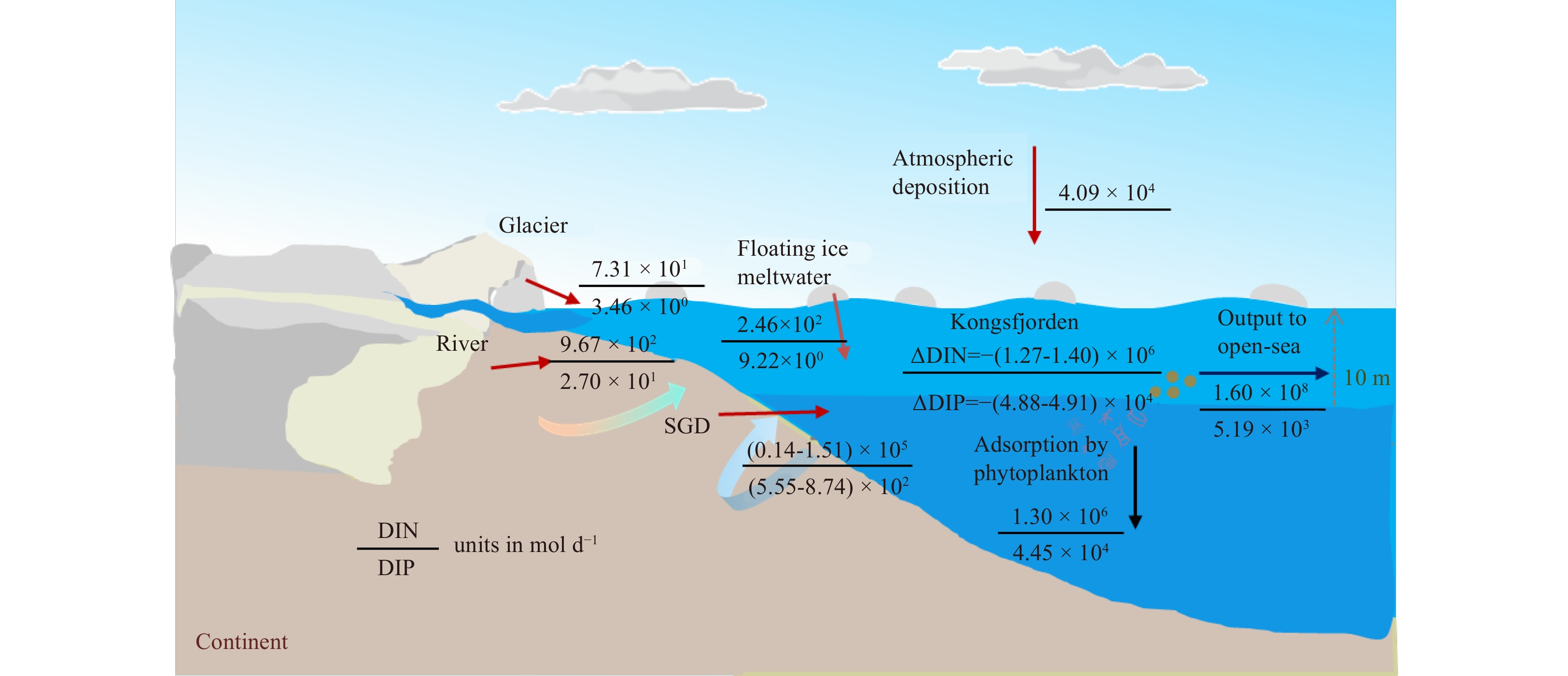
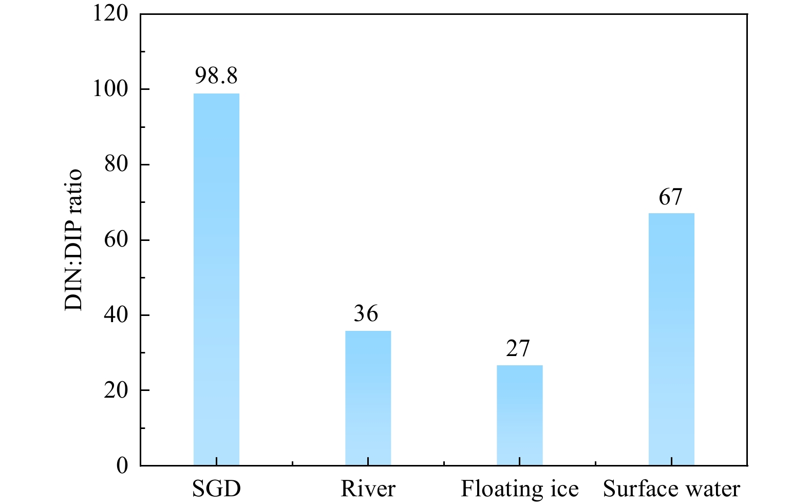
Under global climate change, water flow and related nutrient biogeochemistry in the Arctic are changing at an unprecedented rate, and potentially affect nutrient cycling in the Arctic Ocean. However, nutrient fluxes via submarine groundwater discharge (SGD) are potentially important yet poorly understood in the Arctic. Here we quantified that nutrient fluxes through radium-derived SGD were three orders of magnitude higher than those from the local river and constituted 25-96% of the total nutrient inputs into the Kongsfjorden. These large groundwater nutrient fluxes with high N/P ratio (average 99) may change the biomass and community structure of phytoplankton. Meanwhile, combining other SGD study cases around the Arctic region, SGD rates tend to increase over the past three decades, possibly on account of the effects of global warming. The SGD-derived nutrient may cause the increase of net primary productivity in the Arctic Ocean. The results will provide important basic data for land-ocean interactions in the typical fjord of the Arctic under the influence of global warming.


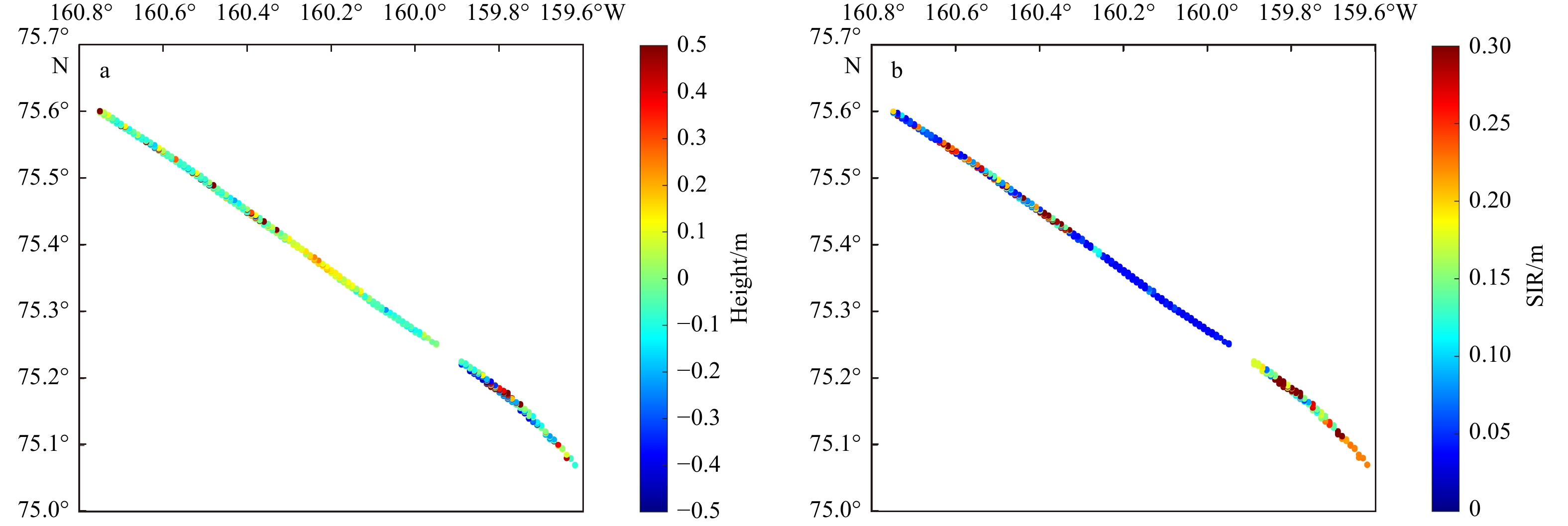
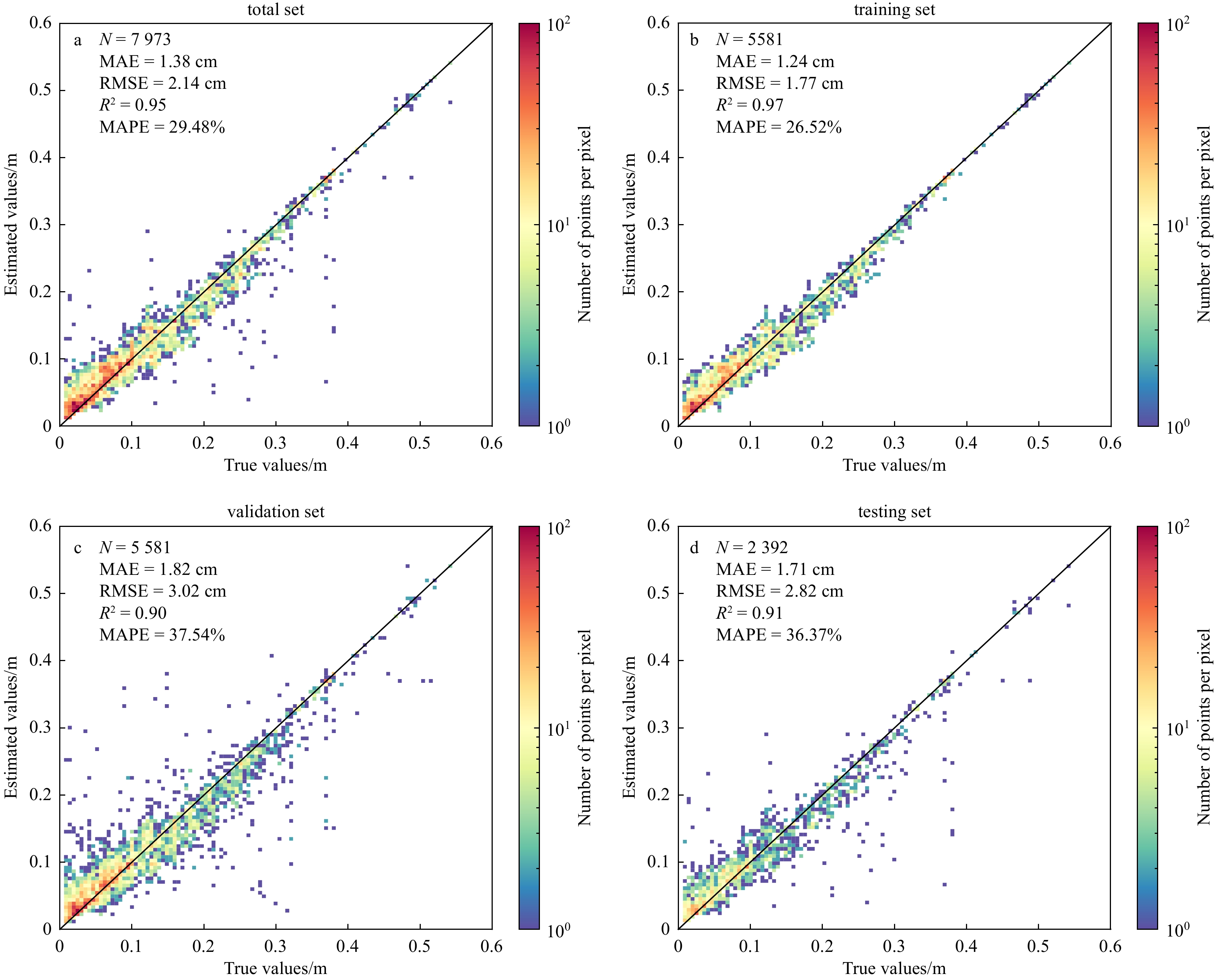
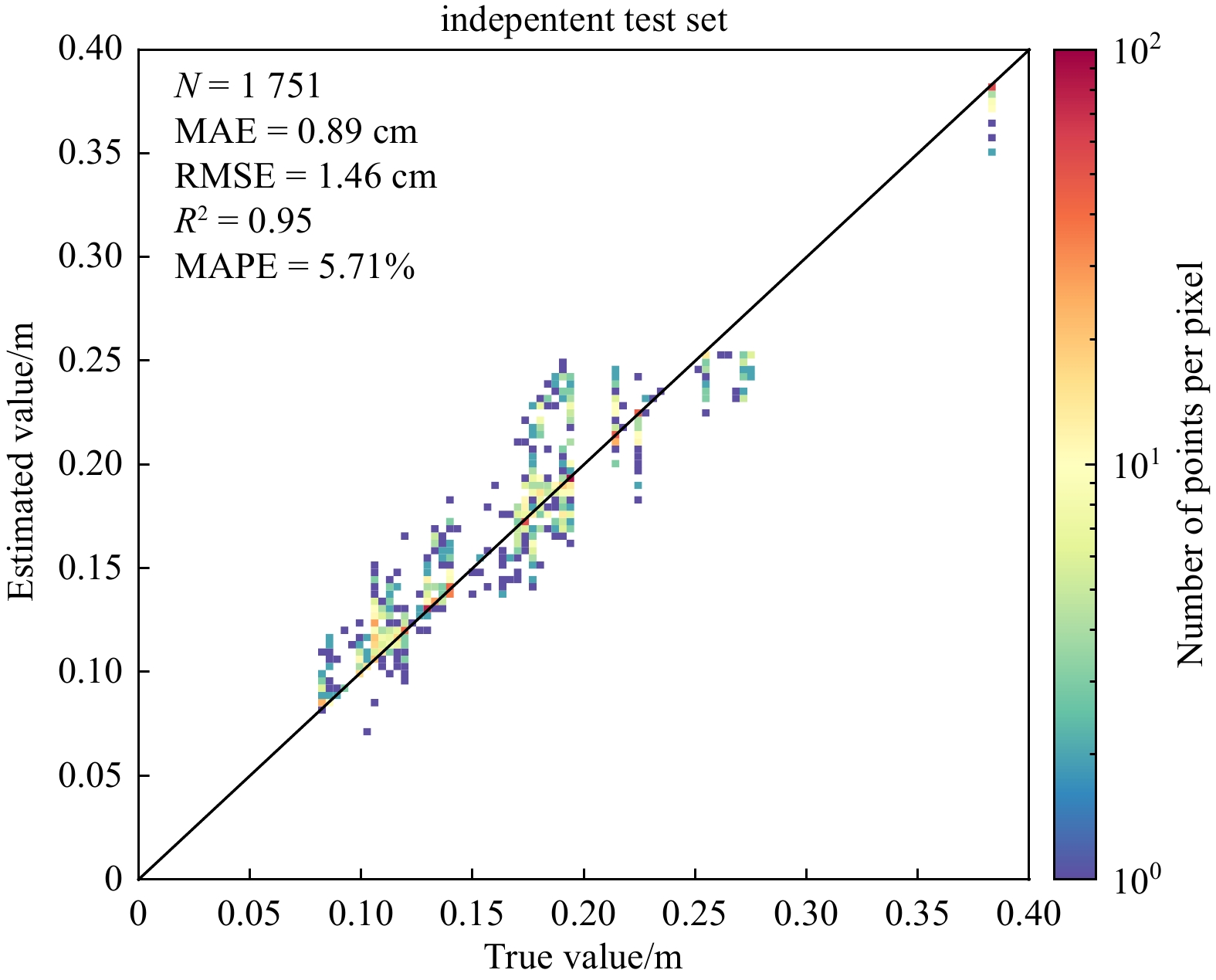
Sea ice surface roughness (SIR) affects the energy transfer between the atmosphere and the ocean, and it is also an important indicator for sea ice characteristics. To obtain a small-scale SIR with high spatial resolution, a novel method is proposed to retrieve SIR from Sentinel-1 synthetic aperture radar (SAR) images, utilizing an ensemble learning method. Firstly, the two-dimensional continuous wavelet transform is applied to obtain the spatial information of sea ice, including the scale and direction of ice patterns. Secondly, a model is developed using the Adaboost Regression model to establish a relationship among SIR, radar backscatter and the spatial information of sea ice. The proposed method is validated by using the SIR retrieved from SAR images and comparing it to the measurements obtained by the Airborne Topographic Mapper (ATM) in the summer Beaufort Sea. The determination of coefficient, mean absolute error, root-mean-square error and mean absolute percentage error of the testing data are 0.91, 1.71 cm, 2.82 cm and 36.37%, respectively, which are reasonable. Moreover, K-fold cross-validation and learning curves are analyzed, which also demonstrate the method's applicability in retrieving SIR from SAR images.


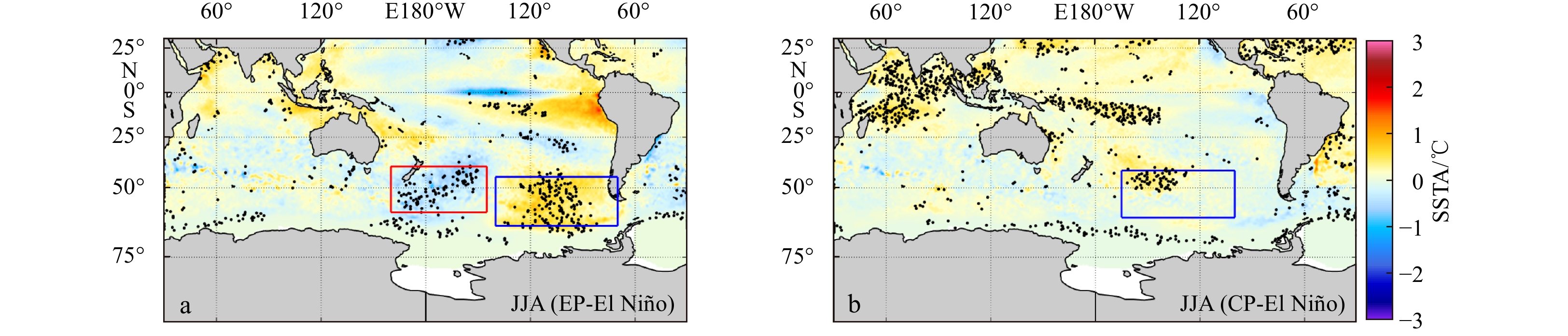
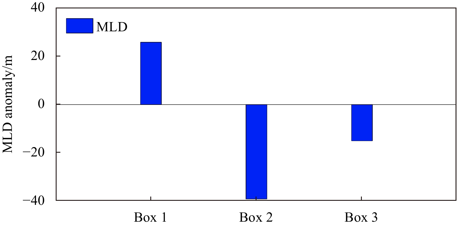
Based on the Ocean Reanalysis System version 5 (ORAS5) and the fifth-generation reanalysis datasets (ERA5) derived from Medium-Range Weather Forecasts (ECMWF), we investigate the different impacts of the Central Pacific (CP) El Niño and the Eastern Pacific (EP) El Niño on the Southern Ocean (SO) mixed layer depth (MLD) during austral winter. The MLD response to the EP El Niño shows a dipole pattern in the South Pacific, namely the MLD dipole, which is the leading El Niño-induced MLD variability in the SO. The tropical Pacific warm sea surface temperature anomaly (SSTA) signal associated with the EP El Niño excites a Rossby wave train propagating southeastward and then enhances the Amundsen Sea Low (ASL). This results in an anomalous cyclone over the Amundsen Sea. As a result, the anomalous southerly wind to the west of this anomalous cyclone advects colder and drier air into the southeast of New Zealand, leading to surface cooling through less total surface heat flux, especially surface sensible heat (SH) flux and latent heat (LH) flux, and thus contributing to the ML deepening. The east of the anomalous cyclone brings warmer and wetter air to the southwest of Chile, but the total heat flux anomaly shows no significant change. The warm air promotes the sea ice melting and maintains fresh water, which strengthens stratification. This results in a shallower MLD. During the CP El Niño, the response of MLD shows a separate negative MLD anomaly center in the central South Pacific. The Rossby wave train triggered by the warm SSTA in the central Pacific Ocean spreads to the Amundsen Sea, which weakens the ASL. Therefore, the anomalous anticyclone dominates the Amundsen Sea. Consequently, the anomalous northerly wind to the west of anomalous anticyclone advects warmer and wetter air into the central and southern Pacific, causing surface warming through increased SH, LH and longwave (LW) radiation flux, and thus contributing to the ML shoaling. However, to the east of the anomalous anticyclone, there is no statistically significant impact on the MLD.


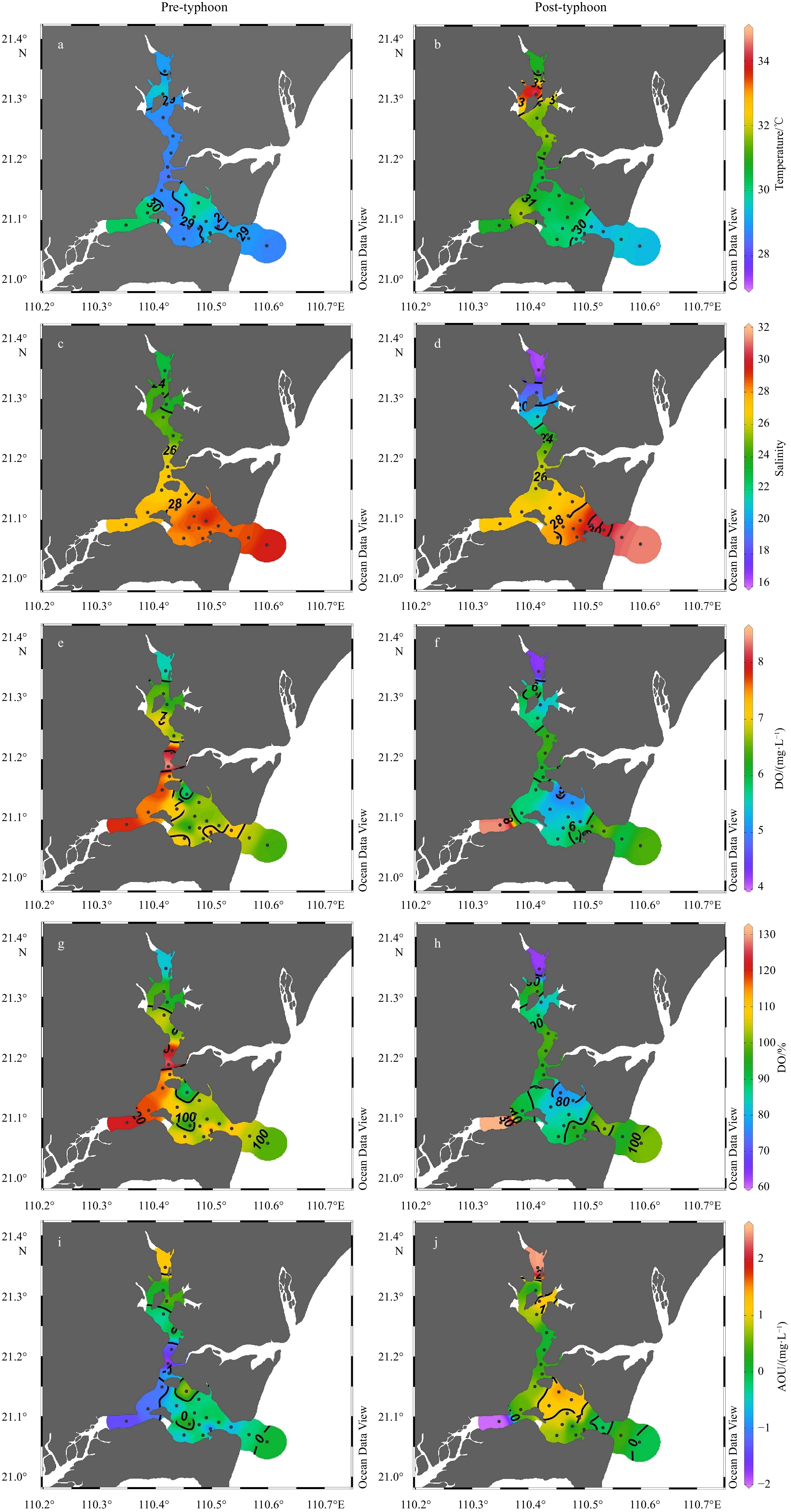
Highly productive estuaries facilitate intense decomposition of dissolved organic matter (DOM) as a carbon source. However, the specific impacts of typhoons on DOM decomposition in eutrophic bays remain unclear. To address this issue, we investigated the spectral characteristics of DOM before and after Typhoon “Ewiniar” in Zhanjiang Bay, a eutrophic semi-enclosed bay in the northwestern South China Sea. The results revealed that intense microbial decomposition of DOM occurred during the pre-typhoon period because high nutrient inputs facilitated the mobilization of DOM in the bay. However, the intrusion of external seawater induced by the typhoon diluted the nutrient levels in Zhanjiang Bay, reducing the impact of microbial decomposition on DOM during the post-typhoon period. Nevertheless, the net addition of DOM occurred in Zhanjiang Bay during the post-typhoon period, possibly because of the decomposition of particulate organic matter (POM) and desorption of particulate matter. In addition, an increase in apparent oxygen utilization, a decrease in DO saturation and the reduced level of Chl a indicated that organic matter (OM) decomposition was enhanced and OM decomposition shifted to POM decomposition in Zhanjiang Bay after the typhoon. Overall, our study highlighted the shift in the intense OM decomposition from DOM to POM decomposition before and after typhoons in eutrophic bays, providing new insights into the response of typhoons to biogeochemistry.


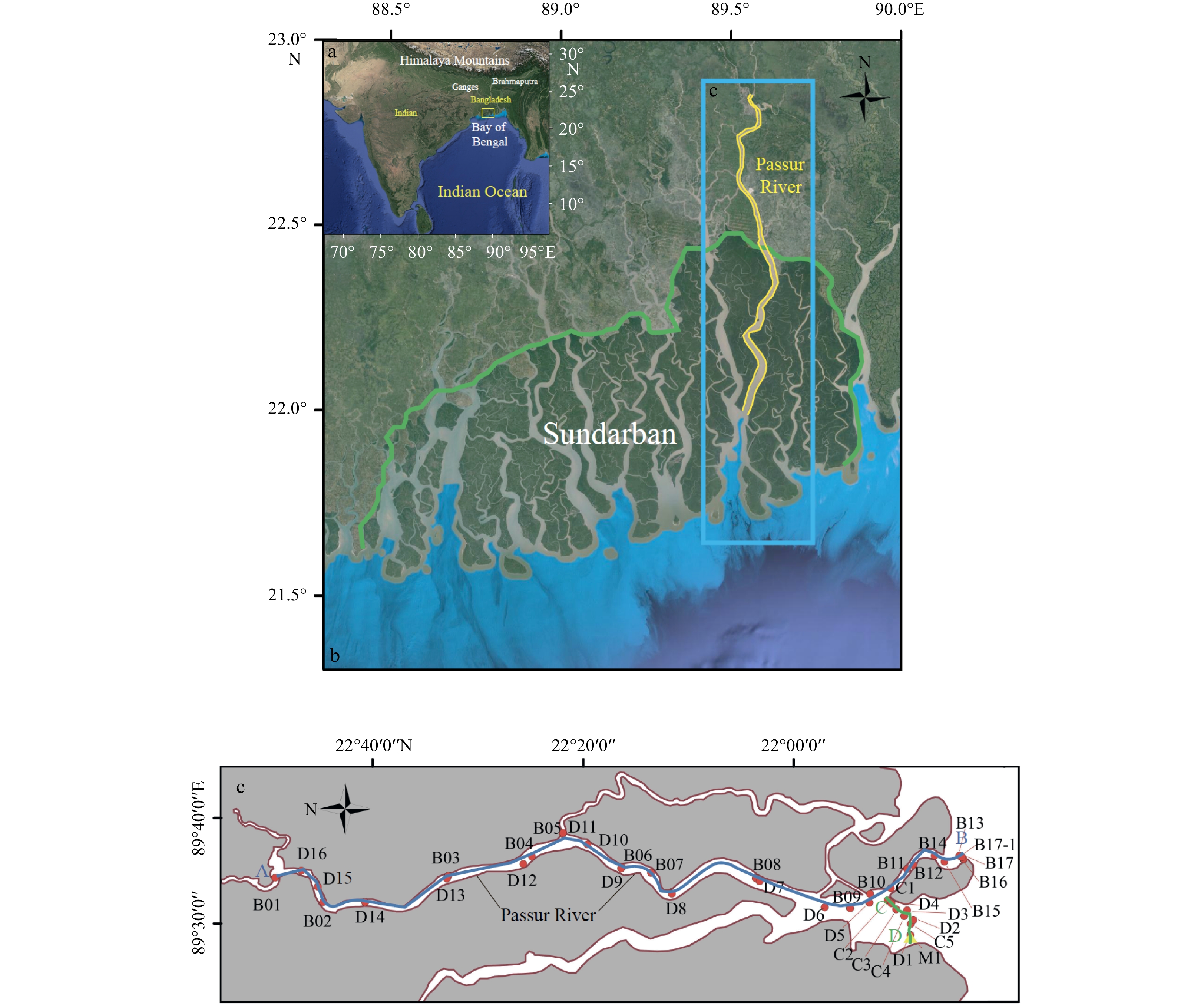
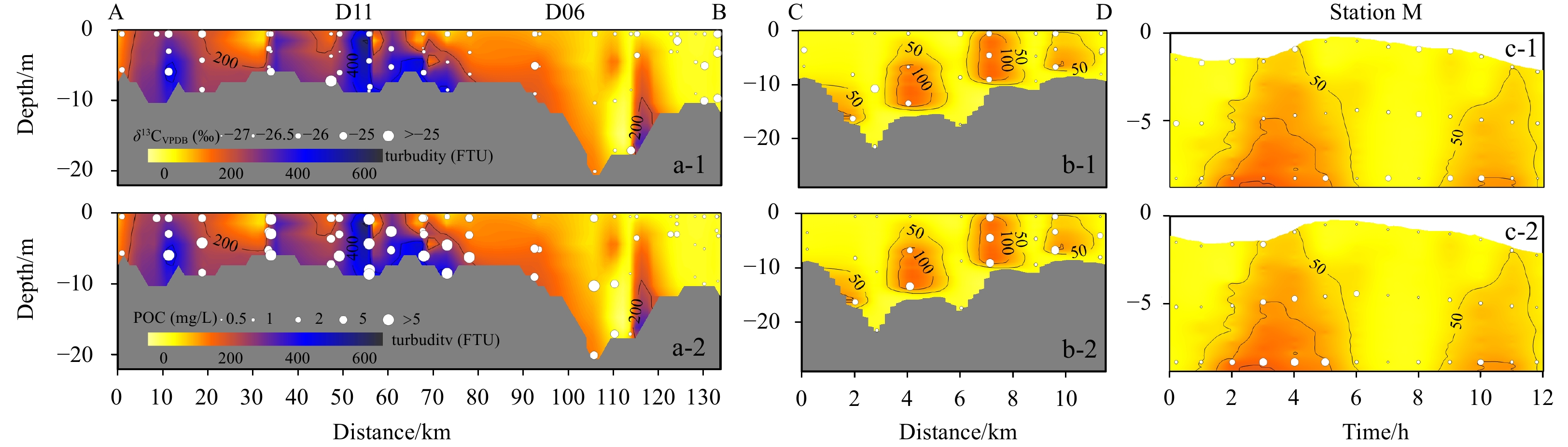
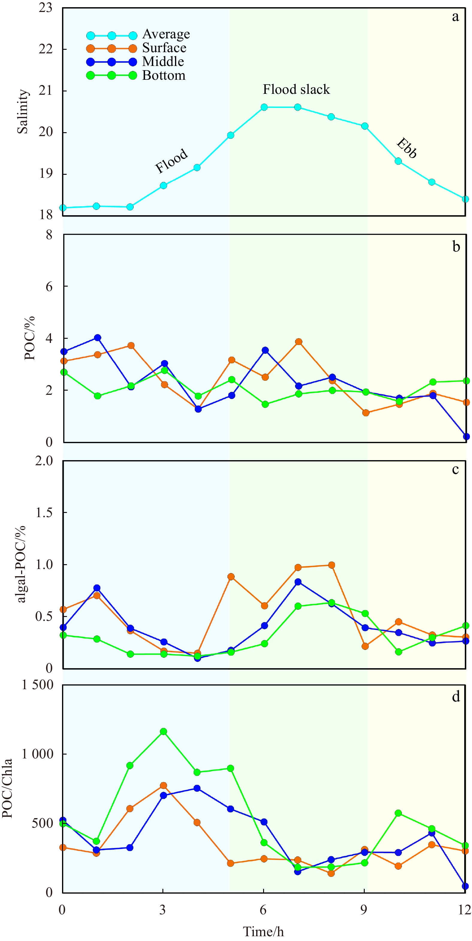
Global carbon cycle has received extensive attention, among which the river-estuary system is one of the important links connecting the carbon cycle between land and ocean. In this paper, the distribution and control factors of particulate organic carbon (POC) were studied by using the data of organic carbon contents and its carbon isotopic composition (δ13C) in the mainstream and estuary of Passur River in the Sundarban area, combined with the hydrological and biological data measured by CTD. The results show that POC content ranged from 0.263 to 9.292 mg/L, and the POC content in the river section (averaged 4.129 mg/L) was significantly higher than that in the estuary area (averaged 0.858 mg/L). Two distinct stages of POC transport from land to sea in the Sundarban area were identified. The first stage occurred in the river section, where POC distribution was mainly controlled by the dynamic process of runoff and the organic carbon was mainly terrestrial source. The second stage occurred during estuarine mixing, where the POC distribution was mainly controlled by the mixing process of seawater and freshwater. The source of POC was predominantly marine and exhibiting vertical differences. The surface and middle layers were primarily influenced by marine sources, while the bottom layer was jointly controlled by terrestrial and marine sources of organic carbon. These findings are of great significance for understanding the carbon cycle in such a large mangrove ecosystem like the Sundarban Mangrove.


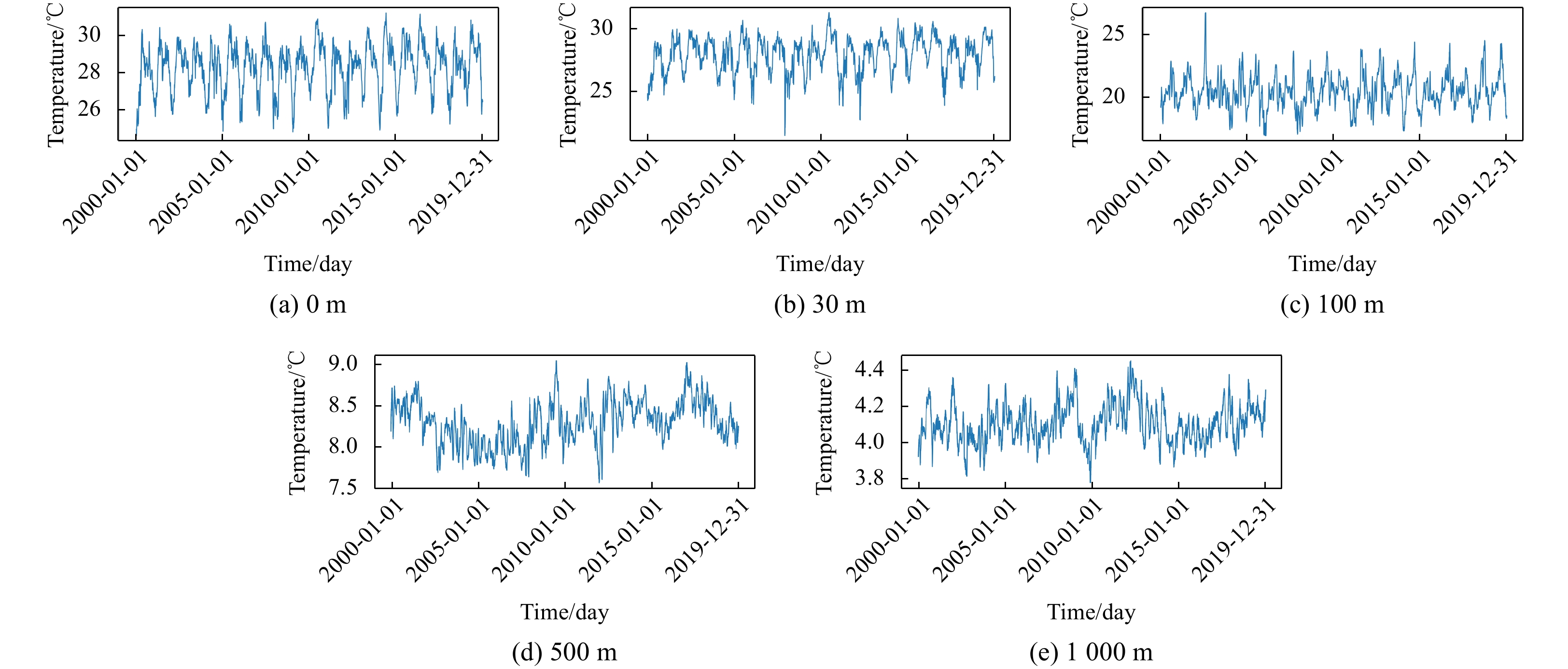
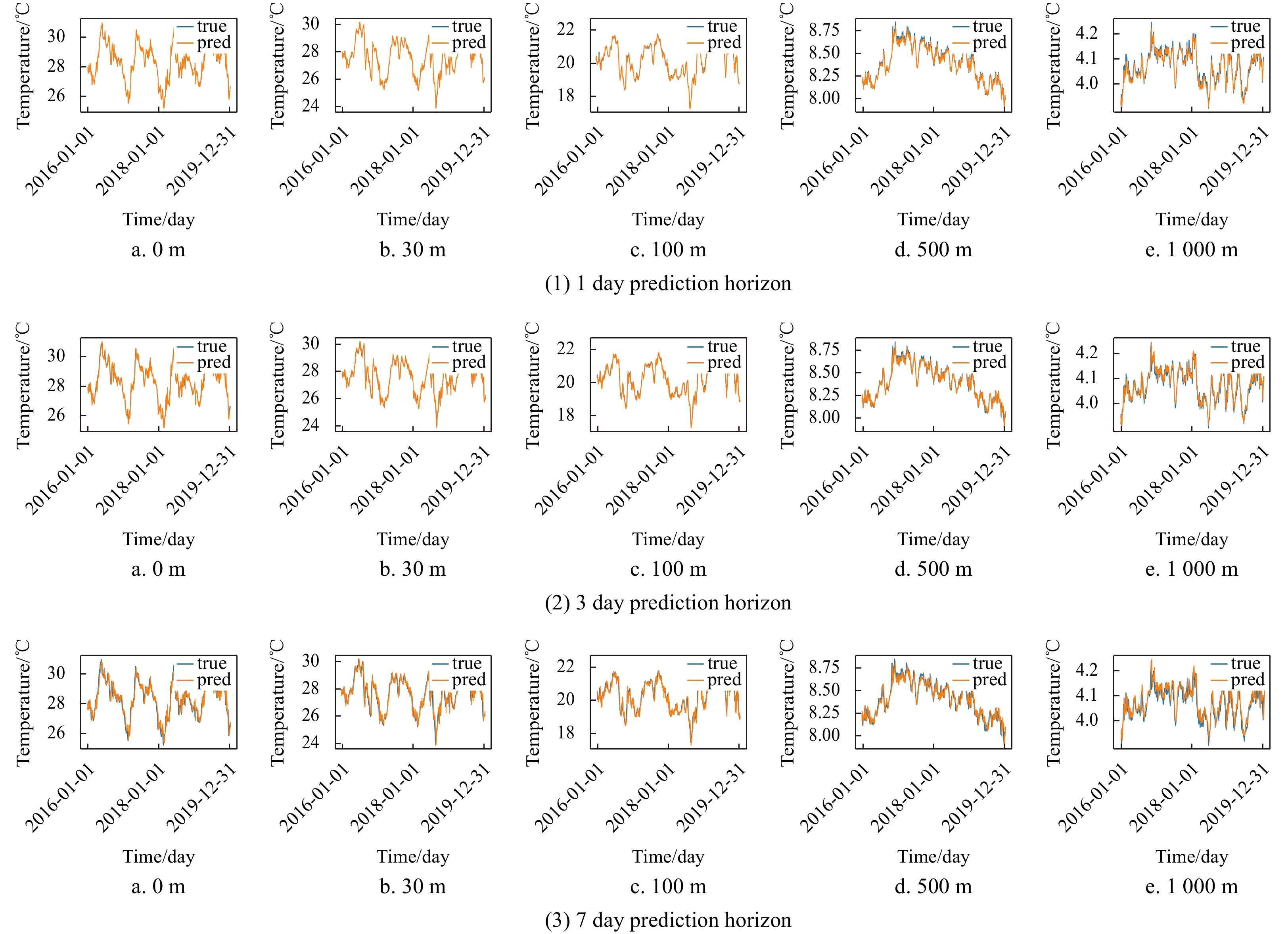
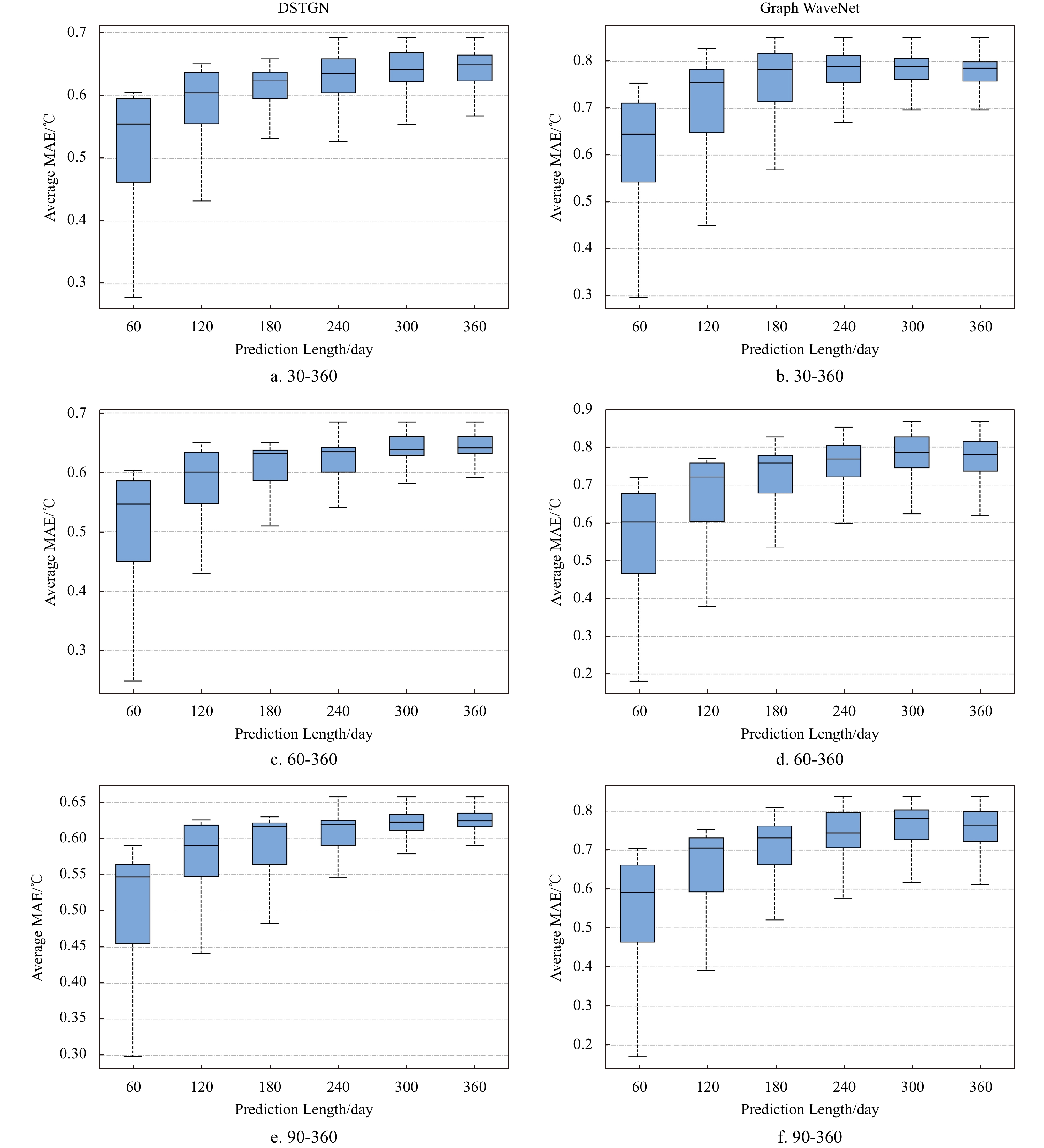
Ocean temperature is an important physical variable in marine ecosystems, and ocean temperature prediction is an important research objective in ocean-related fields. Currently, one of the commonly used methods for ocean temperature prediction is based on data-driven, but research on this method is mostly limited to the sea surface, with few studies on the prediction of internal ocean temperature. Existing graph neural network-based methods usually use predefined graphs or learned static graphs, which cannot capture the dynamic associations among data. In this study, we propose a novel dynamic spatiotemporal graph neural network (DSTGN) to predict three-dimensional ocean temperature (3D-OT), which combines static graph learning and dynamic graph learning to automatically mine two unknown dependencies between sequences based on the original 3D-OT data without prior knowledge. Temporal and spatial dependencies in the time series were then captured using temporal and graph convolutions. We also integrated dynamic graph learning, static graph learning, graph convolution, and temporal convolution into an end-to-end framework for 3D-OT prediction using time-series grid data. In this study, we conducted prediction experiments using high-resolution 3D-OT from the Copernicus global ocean physical reanalysis, with data covering the vertical variation of temperature from the sea surface to 1,000 m below the sea surface. We compared five mainstream models that are commonly used for ocean temperature prediction, and the results showed that the method achieved the best prediction results at all prediction scales.


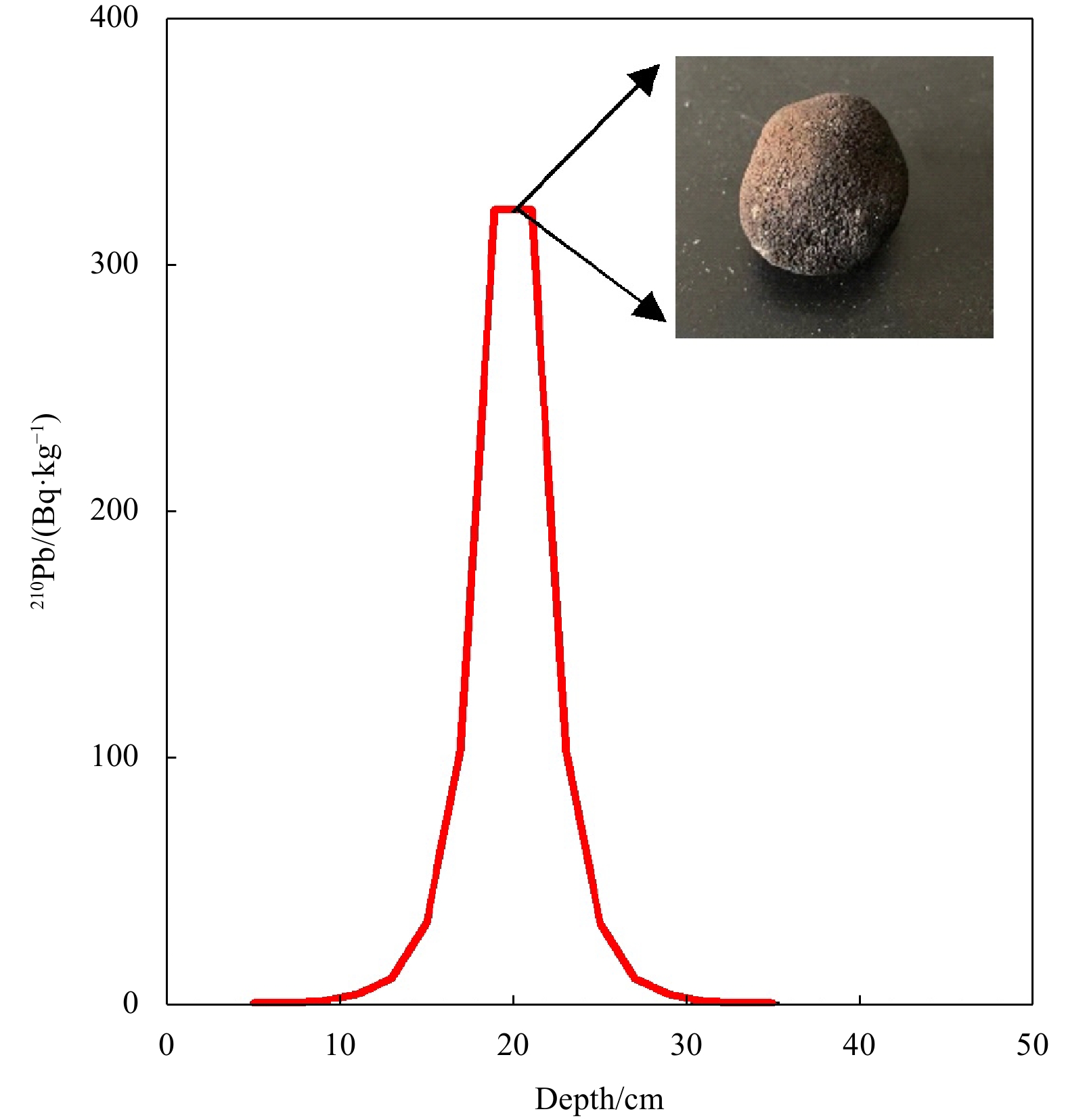
The biogeochemical processes of marine sediments are influenced by bioturbation and organic carbon decomposition, which is crucial for understanding global element cycles and climate change. Two sediment cores were acquired in 2017 from abyssal basins in the central-eastern tropical Pacific to determine the bioturbation and organic carbon degradation processes. The radioactivity concentrations of 210Pb and 226Ra in the sediment cores were measured, indicating the presence of significant excess 210Pb (210Pbex) signals in the sediment cores. Besides, a manganese nodule was discovered in one core, which had a substantial influence on the distribution of 210Pbex. With the exception of this anomalous finding, the bioturbation coefficients in the remaining core were estimated to be 10.6 cm2/a using a steady-state diffusion model, greater than most of the deep-sea sediments from the Equatorial Eastern Pacific. By using a bio-diffusion model, we further calculated the degradation rates of organic carbon (8.02 ka-1), which is also higher than other areas of the Pacific. Our findings displayed the presence of a biologically active benthic ecosystem in the central-eastern tropical Pacific.


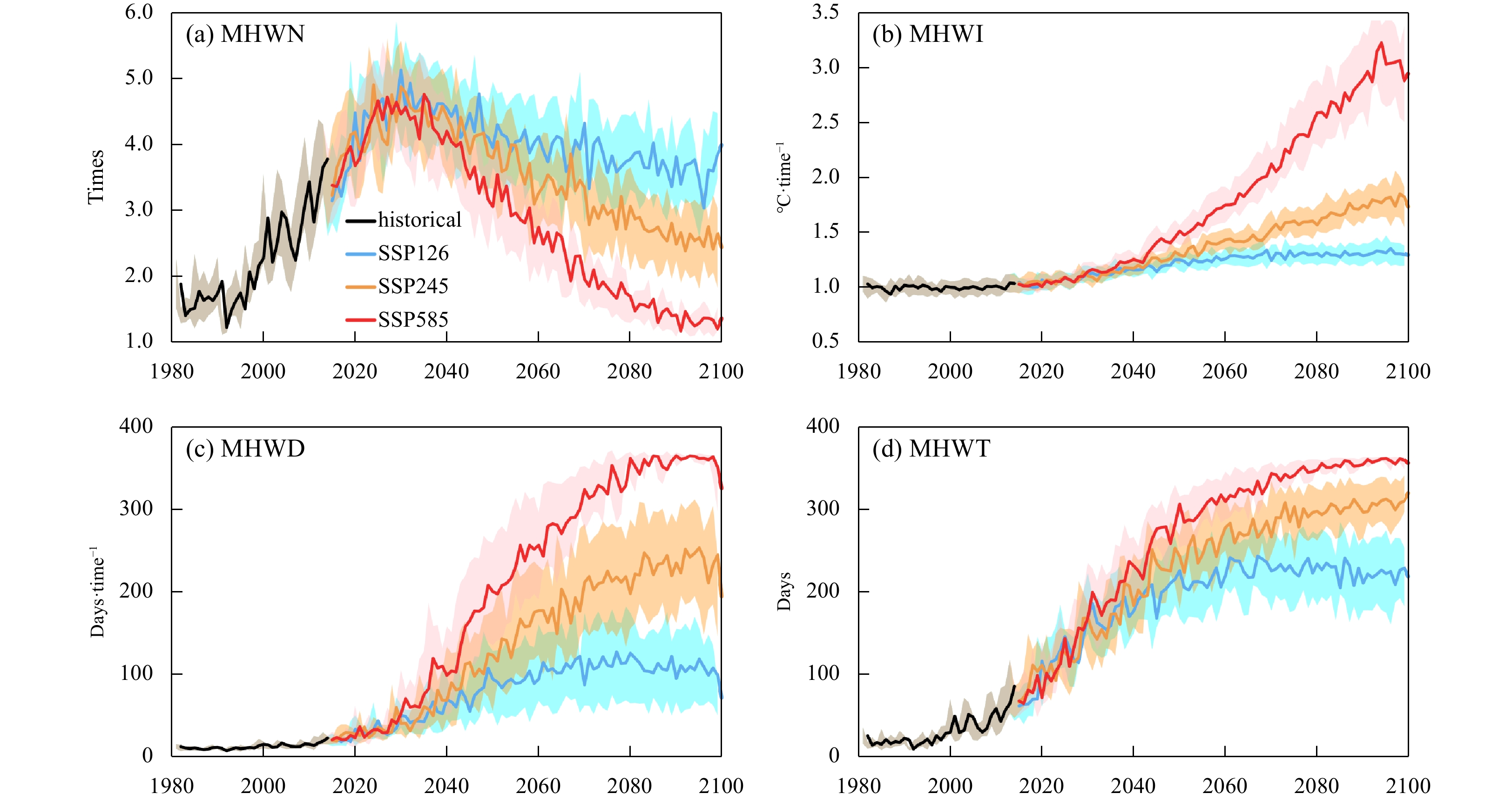
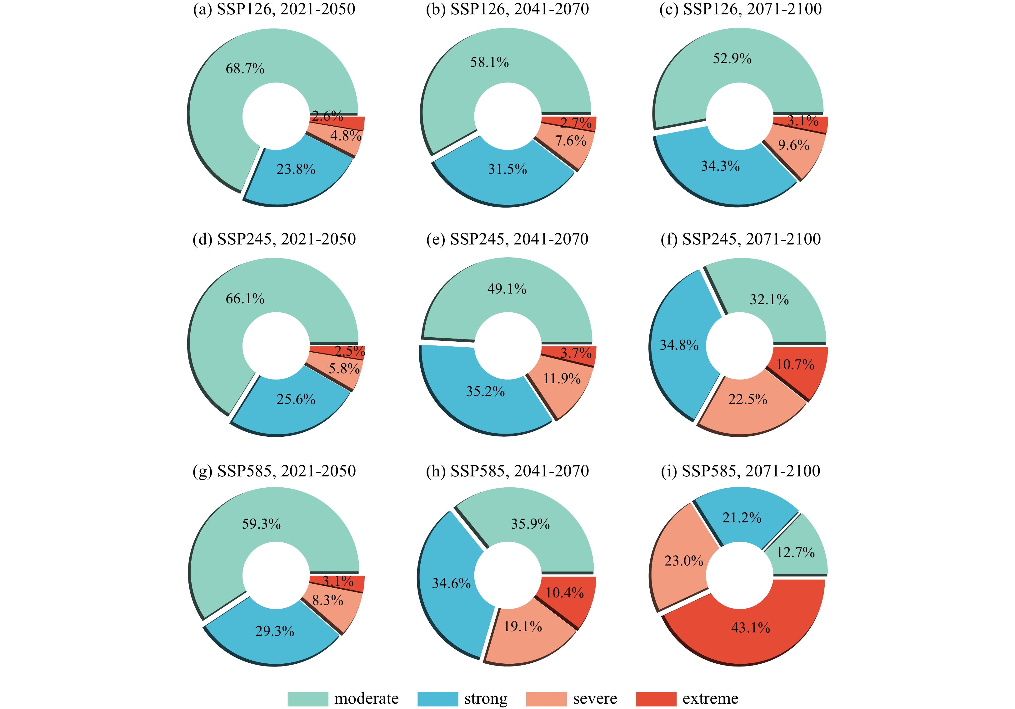
This study evaluates the performance of 16 models sourced from the Coupled Model Intercomparison Project phase 6 (CMIP6) in simulating marine heatwaves (MHWs) in the South China Sea (SCS) during the historical period (1982−2014), and also investigates future changes in SCS MHWs based on simulations from three Shared Socioeconomic Pathway (SSP) scenarios (SSP126, SSP245, and SSP585) using CMIP6 models. Results demonstrate that the CMIP6 models perform well in simulating the spatial-temporal distribution and intensity of SCS MHWs, with their multi-model ensemble (MME) results showing the best performance. The reasonable agreement between the observations and CMIP6 MME reveals that the increasing trends of SCS MHWs are attributed to the warming sea surface temperature trend. Under various SSP scenarios, the year 2040 emerges as pivotal juncture for future shifts in SCS MHWs, marked by distinct variations in changing rate and amplitudes. This is characterized by an accelerated decrease in MHWs frequency and a notably heightened increase in mean intensity, duration, and total days after 2040. Furthermore, the projection results for SCS MHWs suggest that the spatial pattern of MHWs remains consistent across future periods. However, the intensity shows higher consistency only during the near-term period (2021−2050), while notable inconsistencies are observed during the medium-term (2041−2700) and long-term (2701−2100) periods under the three SSP scenarios. During the near-term period, the SCS MHWs are characterized by moderate and strong events with high frequencies and relatively shorter durations. In contrast, during the medium-term period, MHWs are also characterized by moderate and strong events, but with longer-lasting and more intense events under the SSP245 and SSP585 scenarios. However, in the long-term period, extreme MHWs become the dominant feature under the SSP585 scenario, indicating a substantial intensification of SCS MHWs, effectively establishing a near-permanent state.


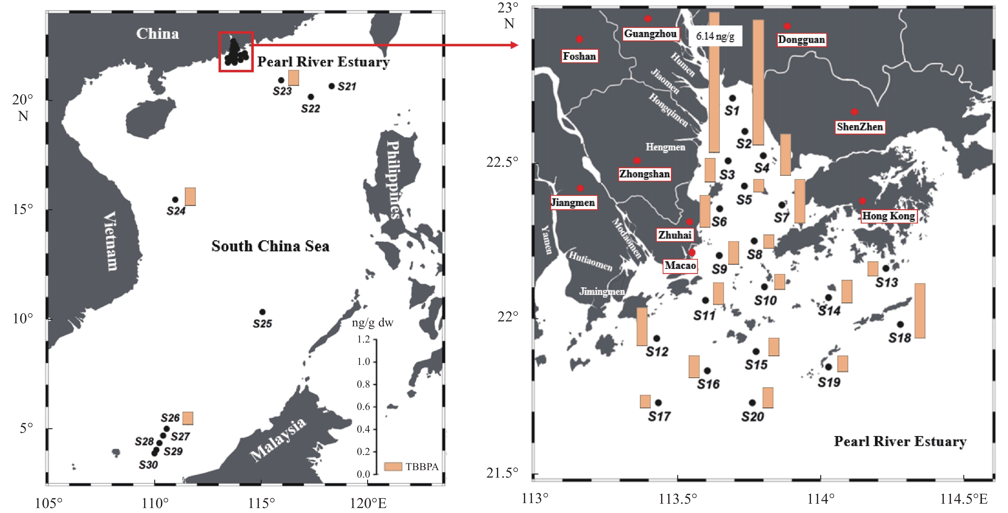
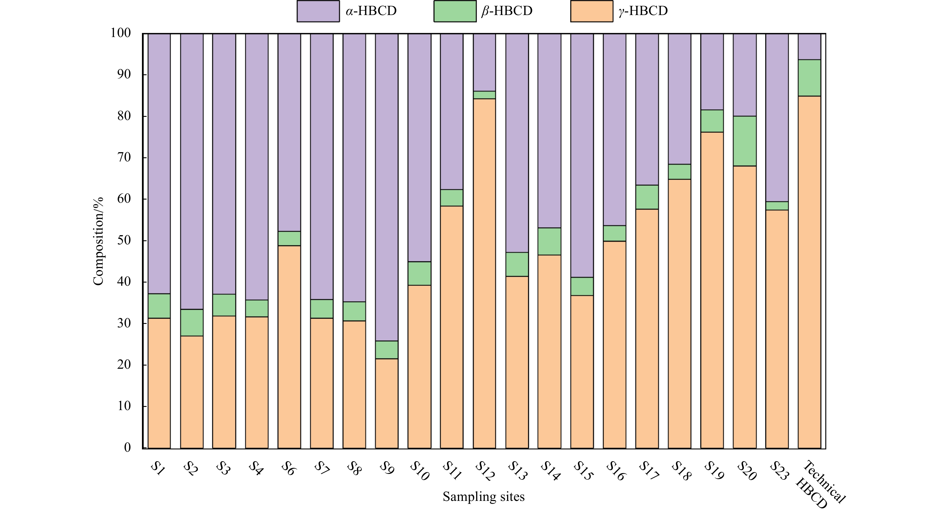
Marine sediments were collected from the Pearl River Estuary (PRE) and South China Sea (SCS) to study the occurrence and spatial distribution of tetrabromobisphenol A (TBBPA) and hexabromocyclododecane (HBCDD). The levels of TBBPA and HBCDD in sediments ranged from not detected (nd) to 6.14 ng/g dry weight (dw) and nd to 0.42 ng/g dw. TBBPA concentrations in marine sediments were substantially higher than HBCDD. The concentrations of TBBPA and HBCDD in the PRE sediments were significantly greater than those in the SCS. α-HBCDD (48.7%) and γ-HBCDD (46.2%) were the two main diastereoisomers of HBCDD in sediments from the PRE, with minor contribution of β-HBCDD (5.1%). HBCDD were only found in one sample from the northern SCS. The enantiomeric fraction of α-HBCDD in sediments from the PRE was obviously greater than 0.5, indicating an accumulation of (+)-α-HBCDD. The enantiomers of HBCDD were not measured in sediments from the SCS. This work highlighted the environmental behaviors of TBBPA and HBCDD in marine sediments.


Seasonal location and intensity changes in the western Pacific subtropical high (WPSH) are important factors dominating the synoptic weather and the distribution and magnitude of precipitation in the rain belt over East Asia. Therefore, this article delves into the forecast of the western Pacific subtropical high index during typhoon activity by adopting a hybrid deep learning model. Firstly, the predictors, which are the inputs of the model, are analysed based on three characteristics: the first is the statistical discipline of the WPSH index anomalies corresponding to the three types of typhoon paths; the second is the correspondence of distributions between sea surface temperature (SST), 850 hPa zonal wind (u), meridional wind (v), and 500 hPa potential height field; and the third is the numerical sensitivity experiment, which reflects the evident impact of variations in the physical field around the typhoon to the WPSH index. Secondly, the model is repeatedly trained through the backward propagation algorithm to predict the WPSH index using 2011-2018 atmospheric variables as the input of the training set. The model predicts the WPSH index after 6 h, 24 h, 48 h, and 72 h. The validation set using independent data in 2019 is utilized to illustrate the performance. Finally, the model is improved by changing the CNN2D module to the DeCNN module to enhance its ability to predict images. Taking the 2019 Typhoon Lekima as an example, it shows the promising performance of this model to predict the 500 hPa potential height field.


Protease-producing bacteria play key roles in the degradation of organic nitrogen materials in marine sediments. However, their diversity, production of proteases and other extracellular enzymes, even in situ ecological functions remain largely unknown. In this study, we investigated the diversity of cultivable extracellular protease-producing bacteria in the sediments of the Bohai Bay. A total of 109 bacterial isolates were obtained from the sediments of 7 stations. The abundance of cultivable protease-producing bacteria was about 104 CFU/g of sediment in all the samples. Phylogenetic analysis based on 16S rRNA gene sequences classified all the isolates into 14 genera from phyla Proteobacteria, Firmicutes, Bacteroidetes and Actinobacteria, with Pseudoalteromonas (63/109, 57.8%), Bacillus (9/109, 8.2%), Sulfitobacter (8/109, 7.3%) and Salegentibacter (6/109, 5.5%) as the dominant taxa. Enzymatic inhibition tests indicated that all the tested isolates produced serine and/or metalloprotease, with only a small proportion producing cysteine and/or aspartic proteases. Several extracellular enzyme activities, including alginase, lipase, amylase and cellulose, and nitrate reduction were also detected for strains with higher protease activities. According the results, the protease-producing bacteria could also be participate in many biogeochemical processes in marine sediments. Our study broadened understanding and knowledge on the potential ecological functions of protease-producing bacteria in marine sediments.


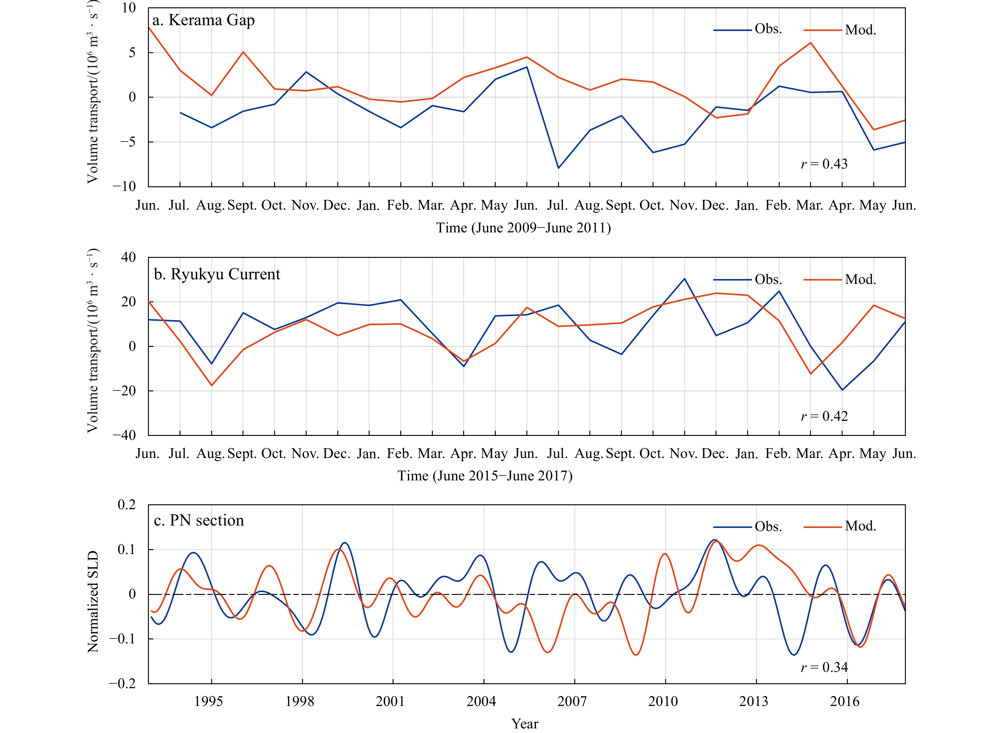
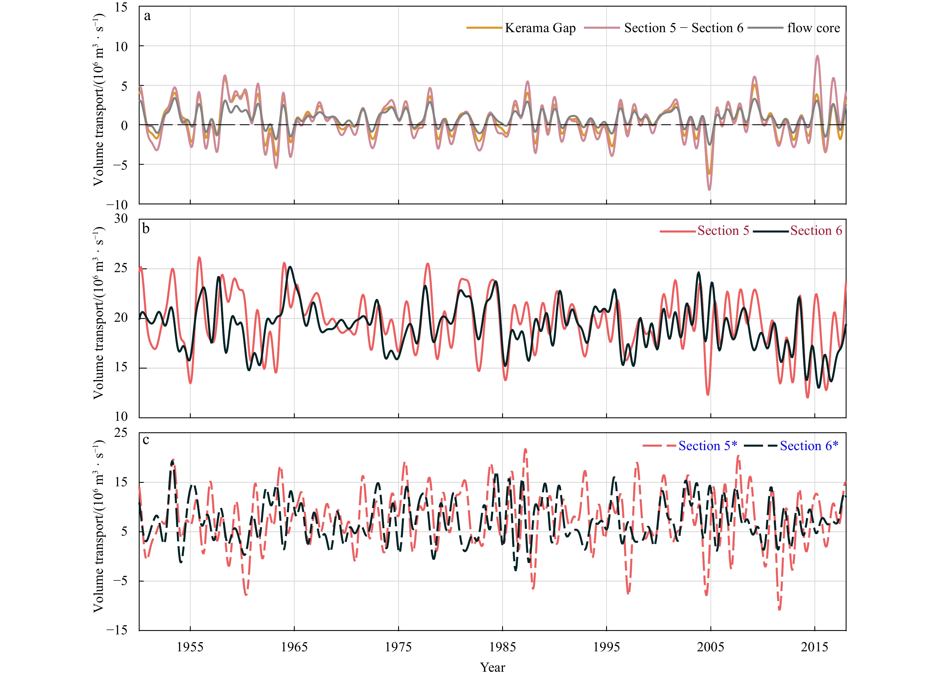
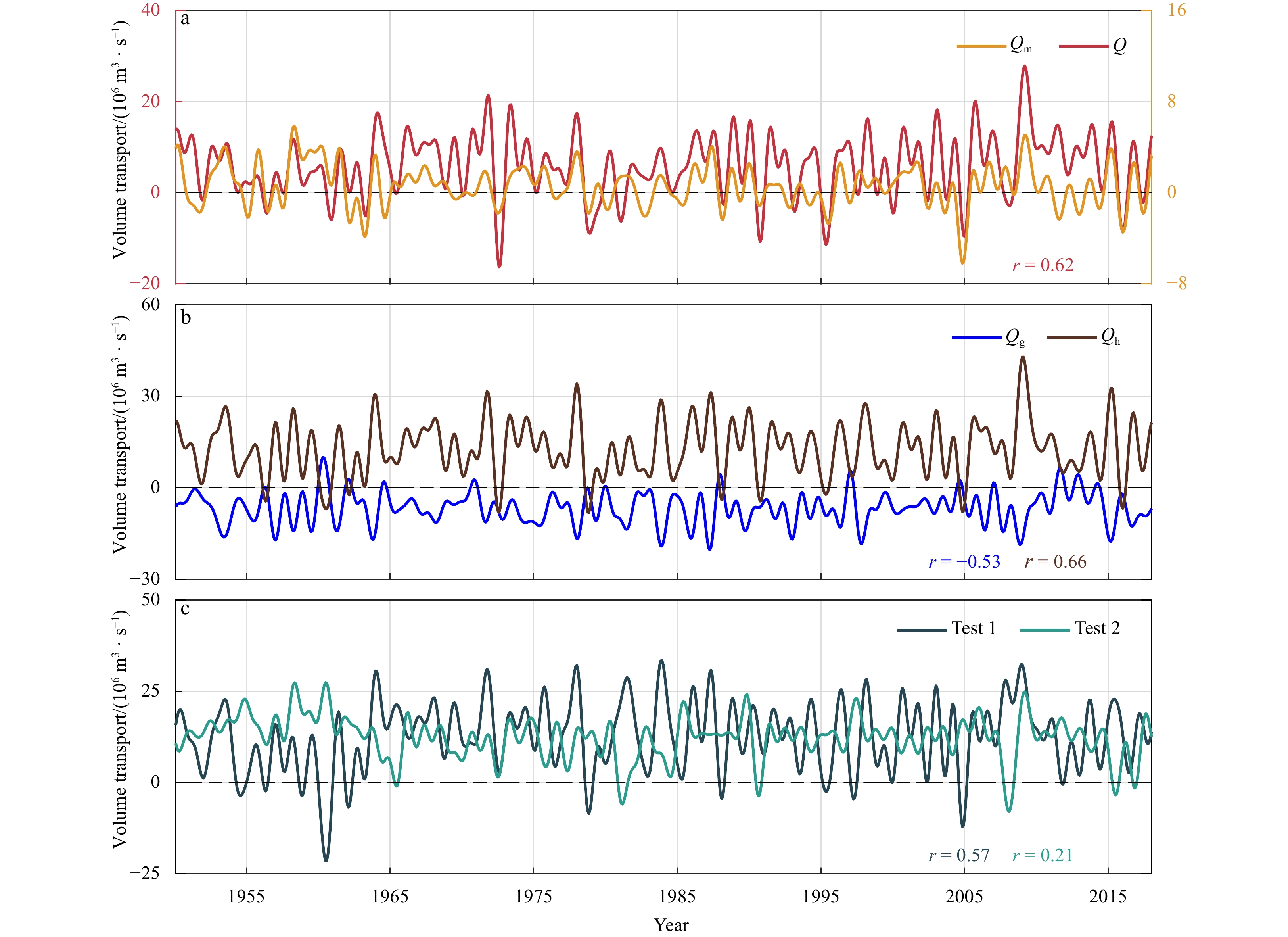
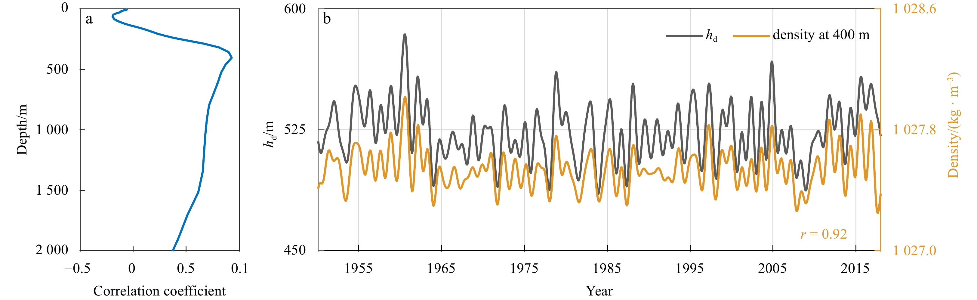
An analysis of a 68-year monthly hindcast output from an eddy-resolving ocean general circulation model reveals the relationship between the interannual variability of the Kerama Gap transport (KGT) and the Kuroshio/Ryukyu Current system. The study found a significant difference in the interannual variability of the upstream and downstream transports of the East China Sea- (ECS-) Kuroshio and the Ryukyu Current. The interannual variability of the KGT was found to be of paramount importance in causing the differences between the upstream and downstream ECS-Kuroshio. Additionally, it contributed approximately 37% to the variability of the Ryukyu Current. The interannual variability of the KGT was well described by a two-layer rotating hydraulic theory. It was dominated by its subsurface-intensified flow core, and the upper layer transport made a weaker negative contribution to the total KGT. The subsurface flow core was found to be mainly driven by the subsurface pressure head across the Kerama Gap, and the pressure head was further dominated by the subsurface density anomalies on the Pacific side. These density anomalies could be traced back to the eastern open ocean, and their propagation speed was estimated to be about 7.4 km/d, which is consistent with the speed of the local first-order baroclinic Rossby wave. When the negative (positive) density anomaly signal reached the southern region of the Kerama Gap, it triggered the increase (decrease) of the KGT towards the Pacific side and the formation of an anticyclonic (cyclonic) vortex by baroclinic adjustment. Meanwhile, there is an increase (decrease) in the upstream transport of the entire Kuroshio/Ryukyu Current system and an offshore flow that decreases (increases) the downstream Ryukyu Current.


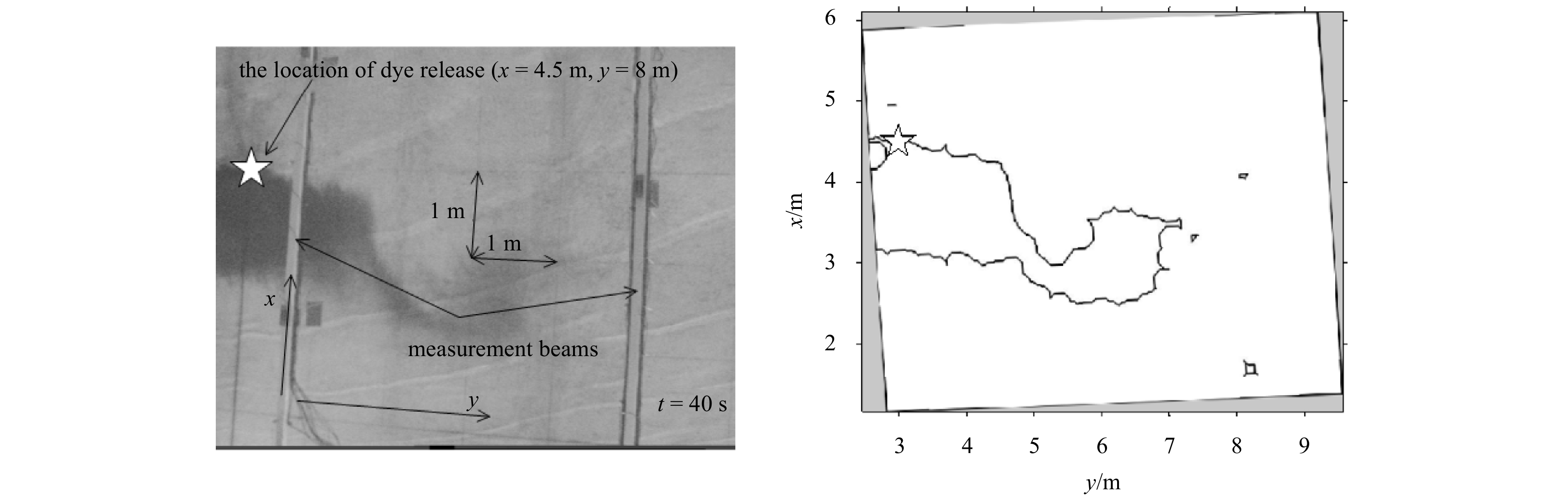
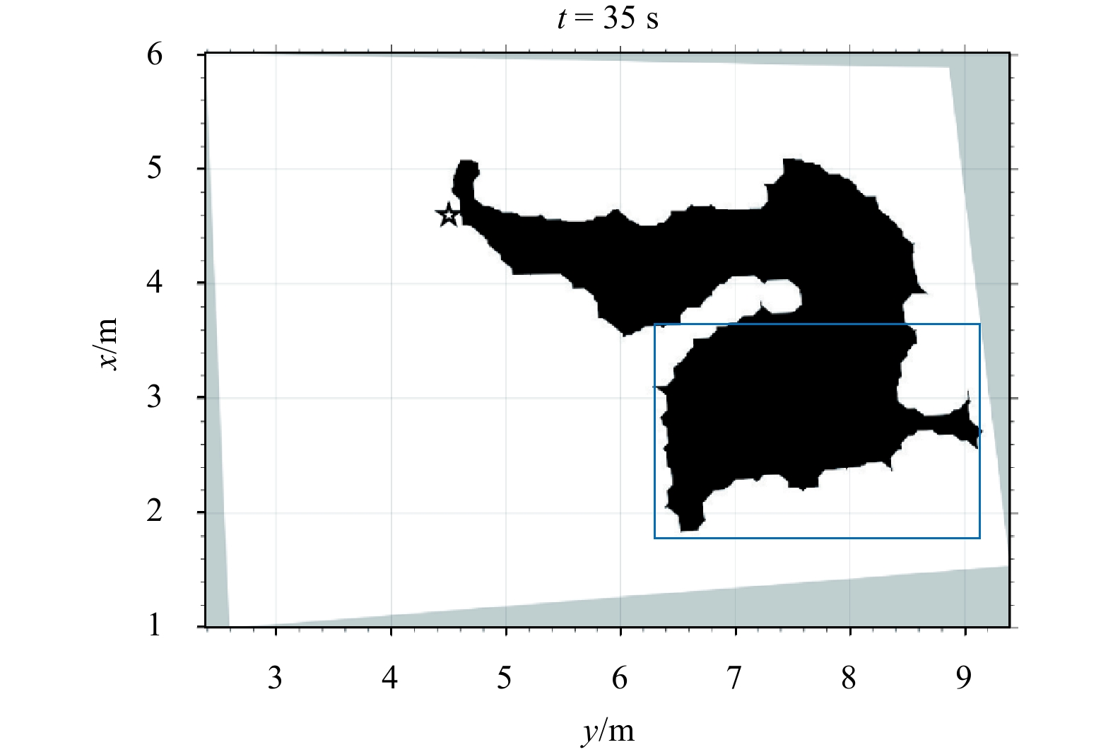
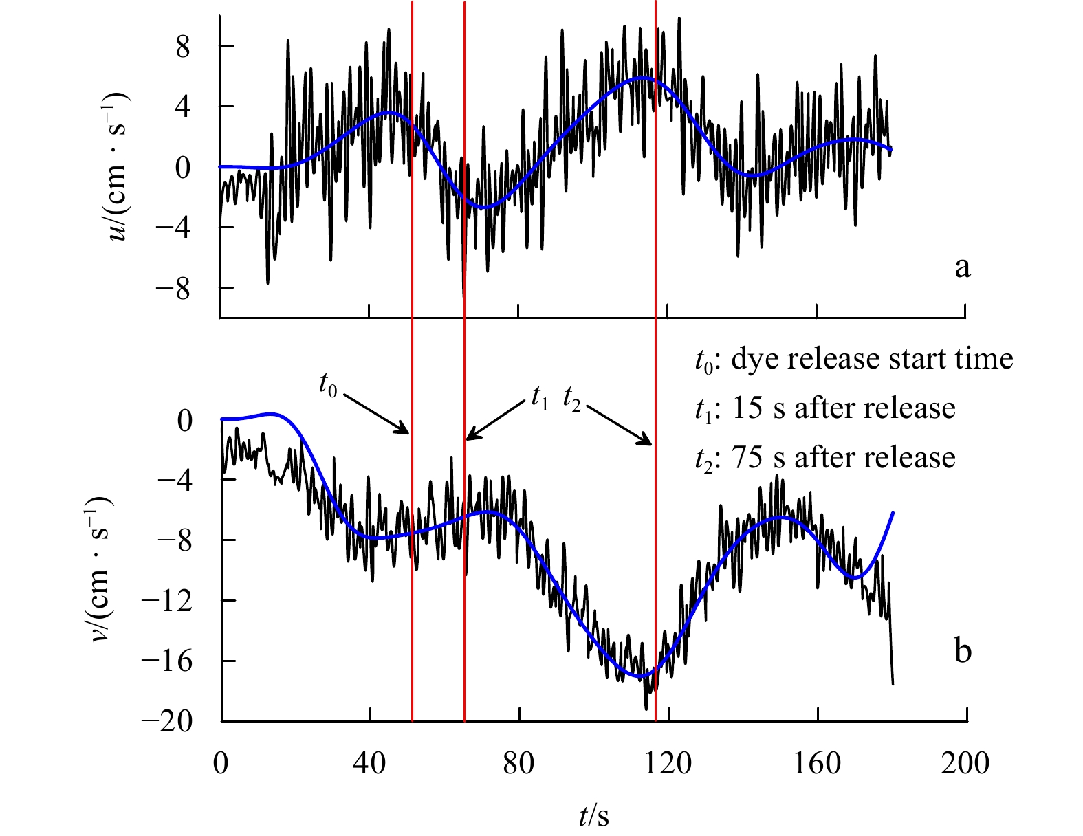
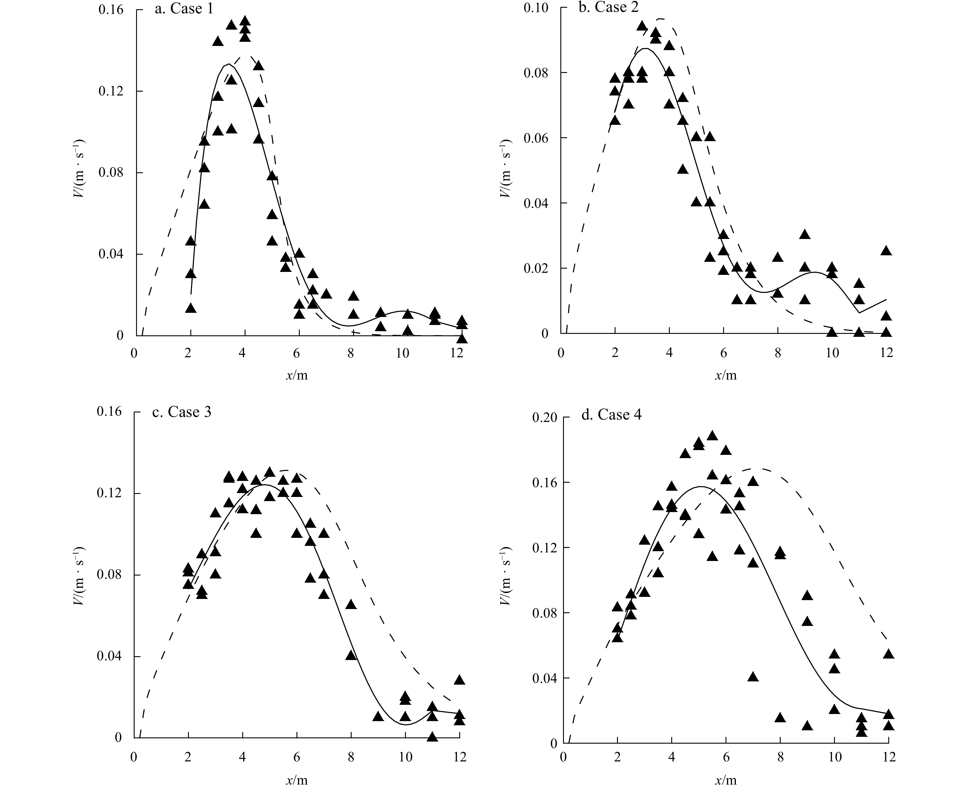
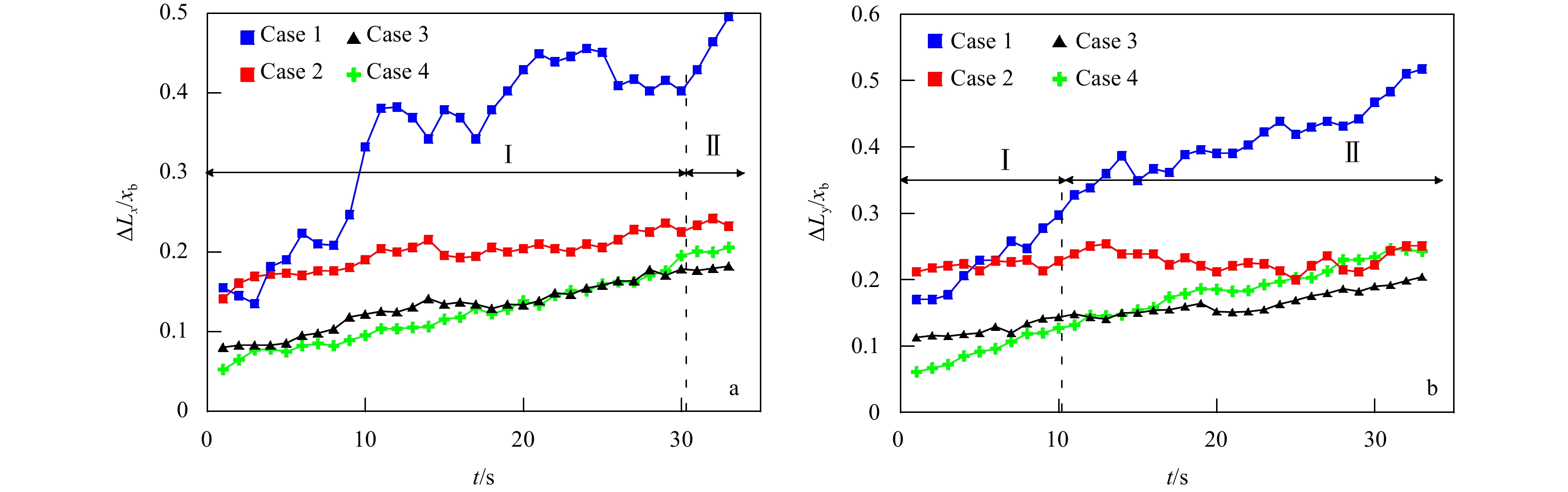
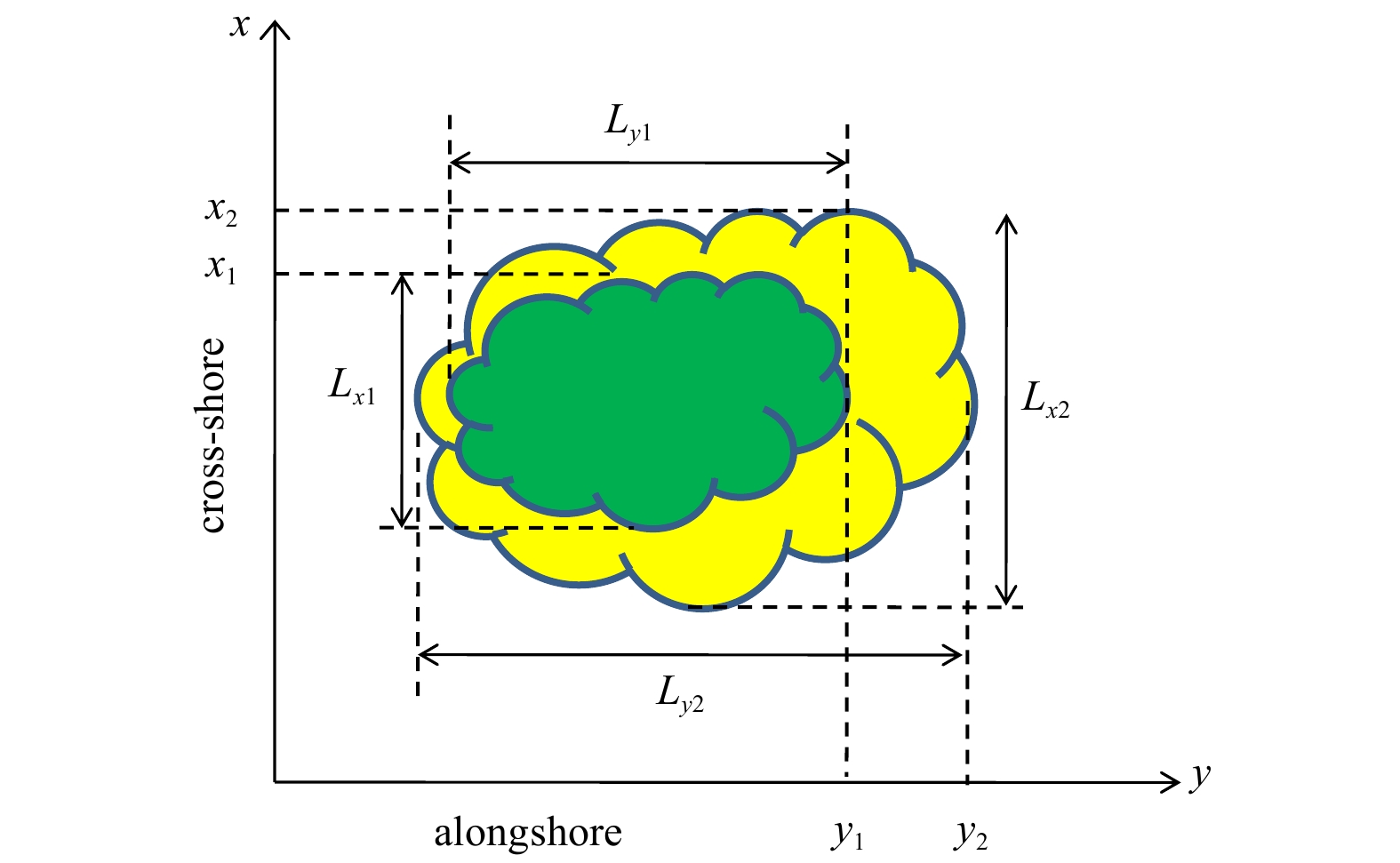
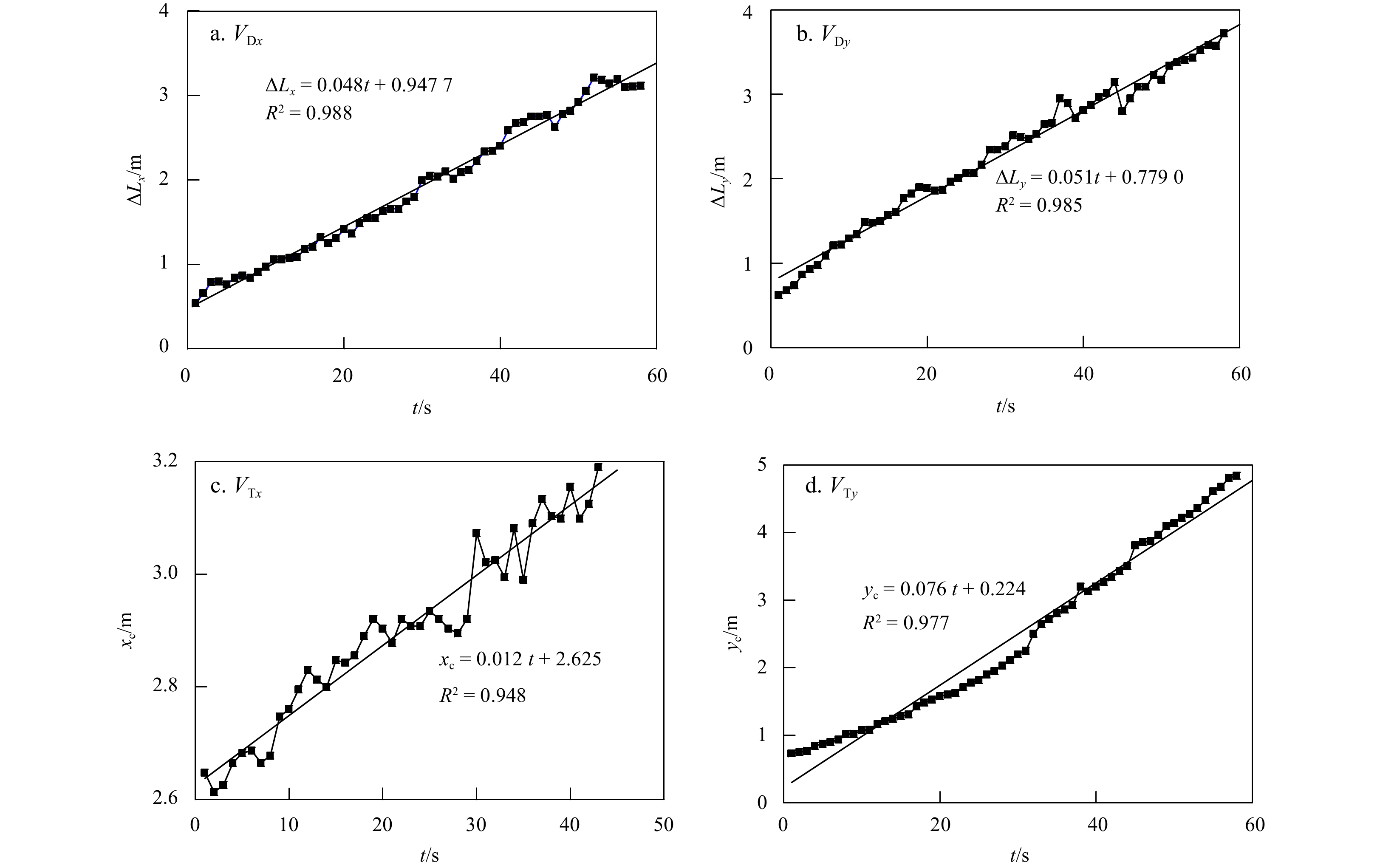
The effects of surf zone eddy generated by alongshore currents on the deformation and transport of dye are still poorly understood, and related tracer release experiments are lacking. Therefore, a tracer release laboratory experiment was conducted under monochromatic, unidirectional incident waves with a large incident angle (30°) on a plane beach with a 1:100 slope in a large wave basin. A charge-coupled device suspended above the basin recorded the dye patch image. The evolution of eddy dye patch was observed and the transport and diffusion were analyzed based on the collected images. Subsequently, a linear instability numerical model was adopted to calculate the perturbation velocity field at the initial stage. The observation and image processing results show that surf zone eddy patches occurred and were separated from the original dye patches. Our numerical analysis results demonstrate that the structure of the perturbation velocity field is consistent with the experimental observations, and that the ejection of eddy patches shoreward or offshore may be ascribed to the double vortex.


An anisotropic diffusion filter can be used to model a flow-dependent background error covariance matrix, which can be achieved by solving the advection-diffusion equation. Because of the directionality of the advection term, the discrete method needs to be chosen very carefully. The finite analytic method is an alternative scheme to solve the advection-diffusion equation. As a combination of analytical and numerical methods, it not only has high calculation accuracy but also holds the characteristic of the auto upwind. To demonstrate its ability, the one-dimensional steady and unsteady advection-diffusion equation numerical examples are respectively solved by the finite analytic method. The more widely used upwind difference method is used as a control approach. The result indicates that the finite analytic method has higher accuracy than the upwind difference method. For the two-dimensional case, the finite analytic method still has a better performance. In the three-dimensional variational assimilation experiment, the finite analytic method can effectively improve analysis field accuracy, and its effect is significantly better than the upwind difference and the central difference method. Moreover, it is still a more effective solution method in the strong flow region where the advective-diffusion filter performs most prominently.


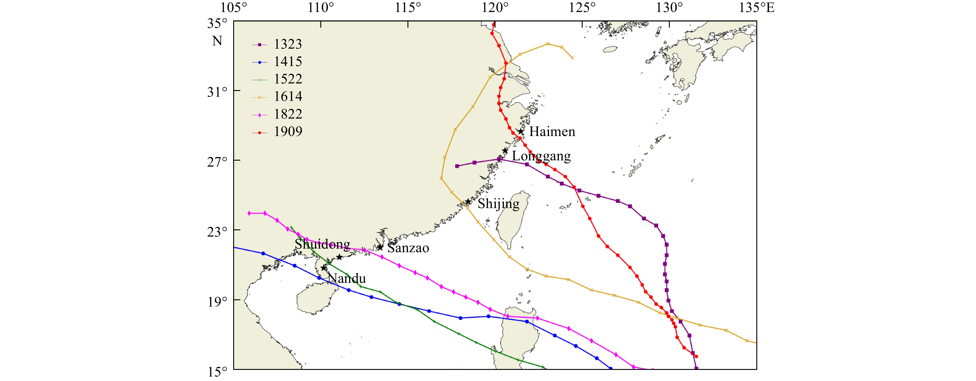
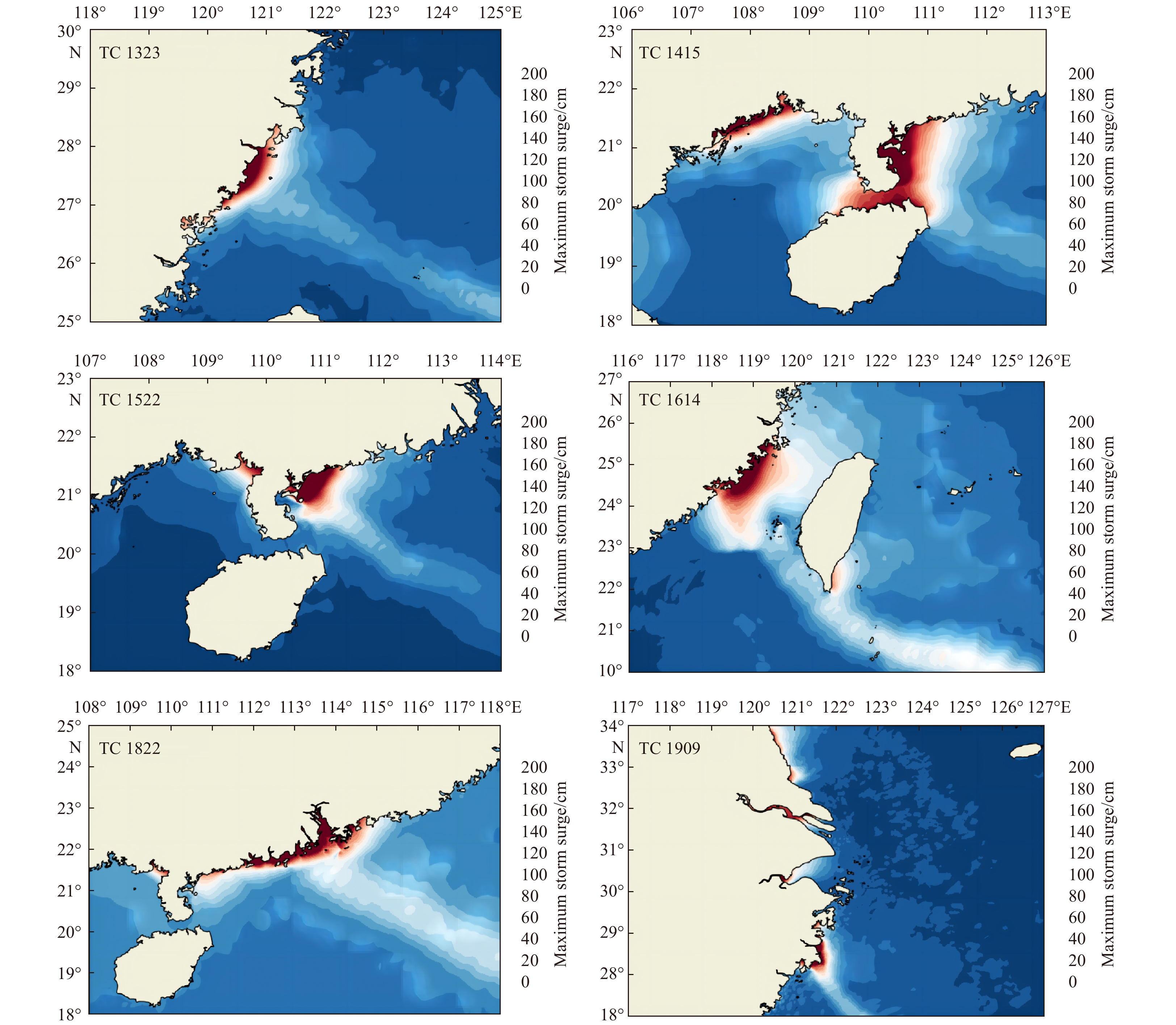
Storm surge is often the marine disaster that poses the greatest threat to life and property in coastal areas. Accurate and timely issuance of storm surge warnings to take appropriate countermeasures is an important means to reduce storm surge-related losses. Storm surge numerical models are important for storm surge forecasting. To further improve the performance of the storm surge forecast models, we developed a numerical storm surge forecast model based on an unstructured spherical centroidal Voronoi tessellation (SCVT) grid. The model is based on shallow water equations in vector-invariant form, and is discretized by Arakawa C grid. The SCVT grid can not only better describe the coastline information but also avoid rigid transitions, and it has a better global consistency by generating high-resolution grids in the key areas through transition refinement. In addition, the simulation speed of the model is accelerated by using the openACC-based GPU acceleration technology to meet the timeliness requirements of operational ensemble forecast. It only takes 37 s to simulate a day in the coastal waters of China. The newly developed storm surge model was applied to simulate typhoon-induced storm surges in the coastal waters of China. The hindcast experiments on the selected representative typhoon-induced storm surge processes indicate that the model can reasonably simulate the distribution characteristics of storm surges. The simulated maximum storm surges and their occurrence times are consistent with the observed data at the representative tide gauge stations, and the mean absolute errors are 3.5 cm and 0.6 h respectively, showing high accuracy and application prospects.


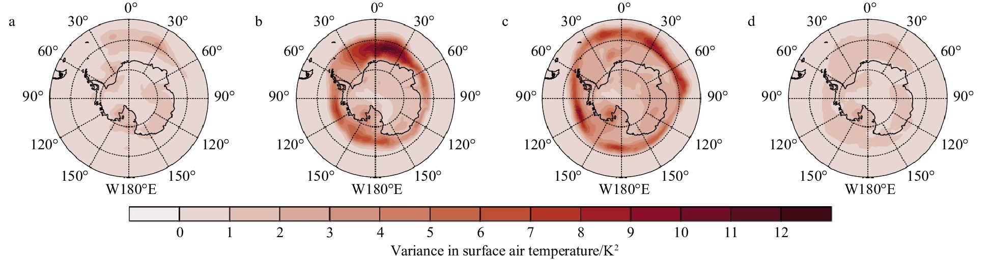
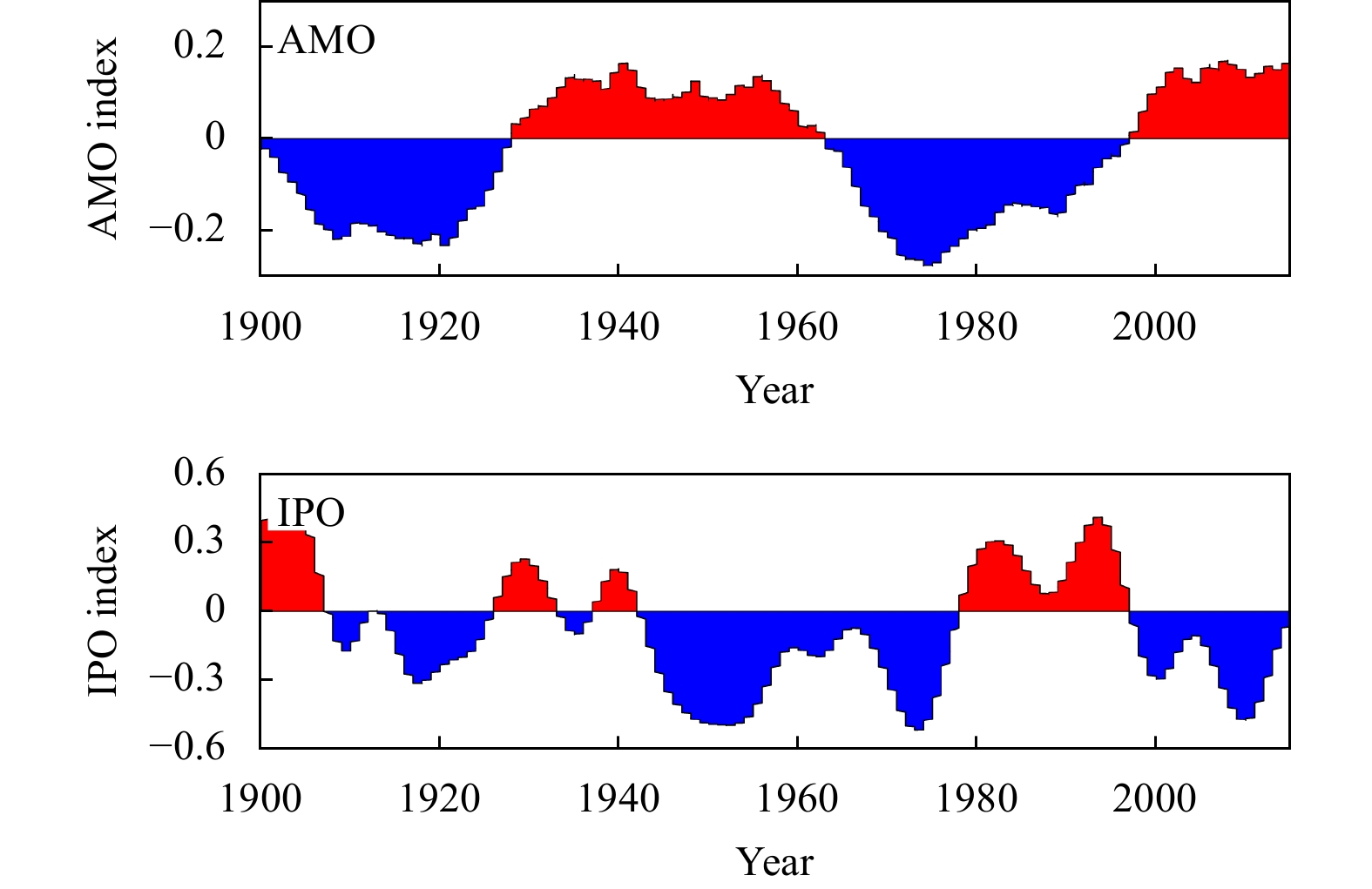
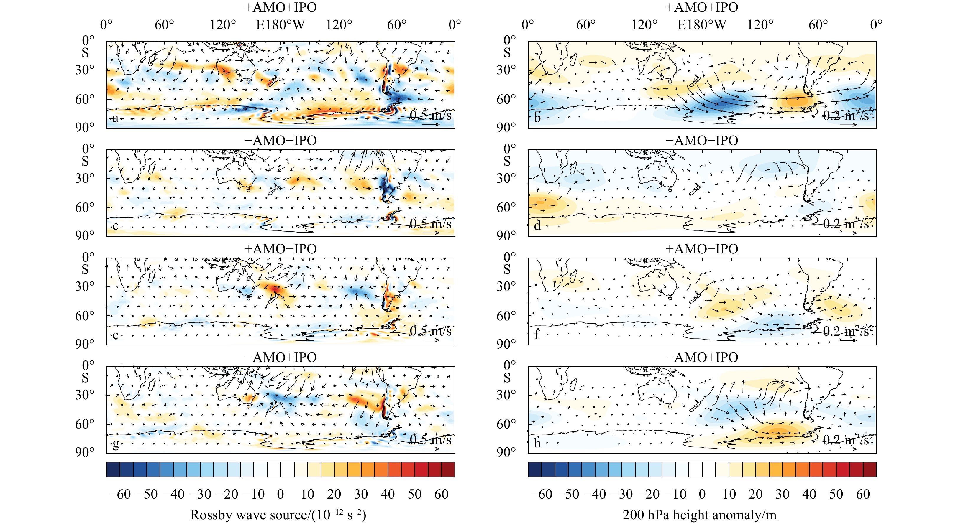
The importance of the Atlantic Multidecadal Oscillation (AMO) and Interdecadal Pacific Oscillation (IPO) in influencing zonally asymmetric changes in Antarctic surface air temperature (SAT) has been established. However, previous studies have primarily concentrated on examining the combined impact of the contrasting phases of the AMO and IPO, which have been dominant since the advent of satellite observations in 1979. This study utilizes long-term reanalysis data to investigate the impact of four combinations of +AMO+IPO, –AMO–IPO, +AMO–IPO, and –AMO+IPO on Antarctic SAT over the past 115 years. The +AMO phase is characterized by a spatial mean temperature amplitude of up to 0.5℃ over the North Atlantic Ocean, accompanied by positive sea surface temperature (SST) anomalies in the tropical eastern Pacific and negative SST anomalies in the extratropical-mid-latitude western Pacific, which are indicative of the +IPO phase. The Antarctic SAT exhibits contrasting spatial patterns during the +AMO+IPO and +AMO–IPO periods. However, during the –AMO+IPO period, apart from the Antarctic Peninsula and the vicinity of the Weddell Sea, the entire Antarctic region experiences a warming trend. The most pronounced signal in the SAT anomalies is observed during the austral autumn, whereas the combination of –AMO and –IPO exhibits the smallest magnitude across all the combinations. The wavetrain excited by the SST anomalies associated with the AMO and IPO induces upper-level and surface atmospheric circulation anomalies, which alter the SAT anomalies. Furthermore, downward longwave radiation anomalies related to anomalous cloud cover play a crucial role. In the future, if the phases of AMO and IPO were to reverse (AMO transitioning to a negative phase and IPO transitioning to a positive phase), Antarctica could potentially face more pronounced warming and accelerated melting compared to the current observations.


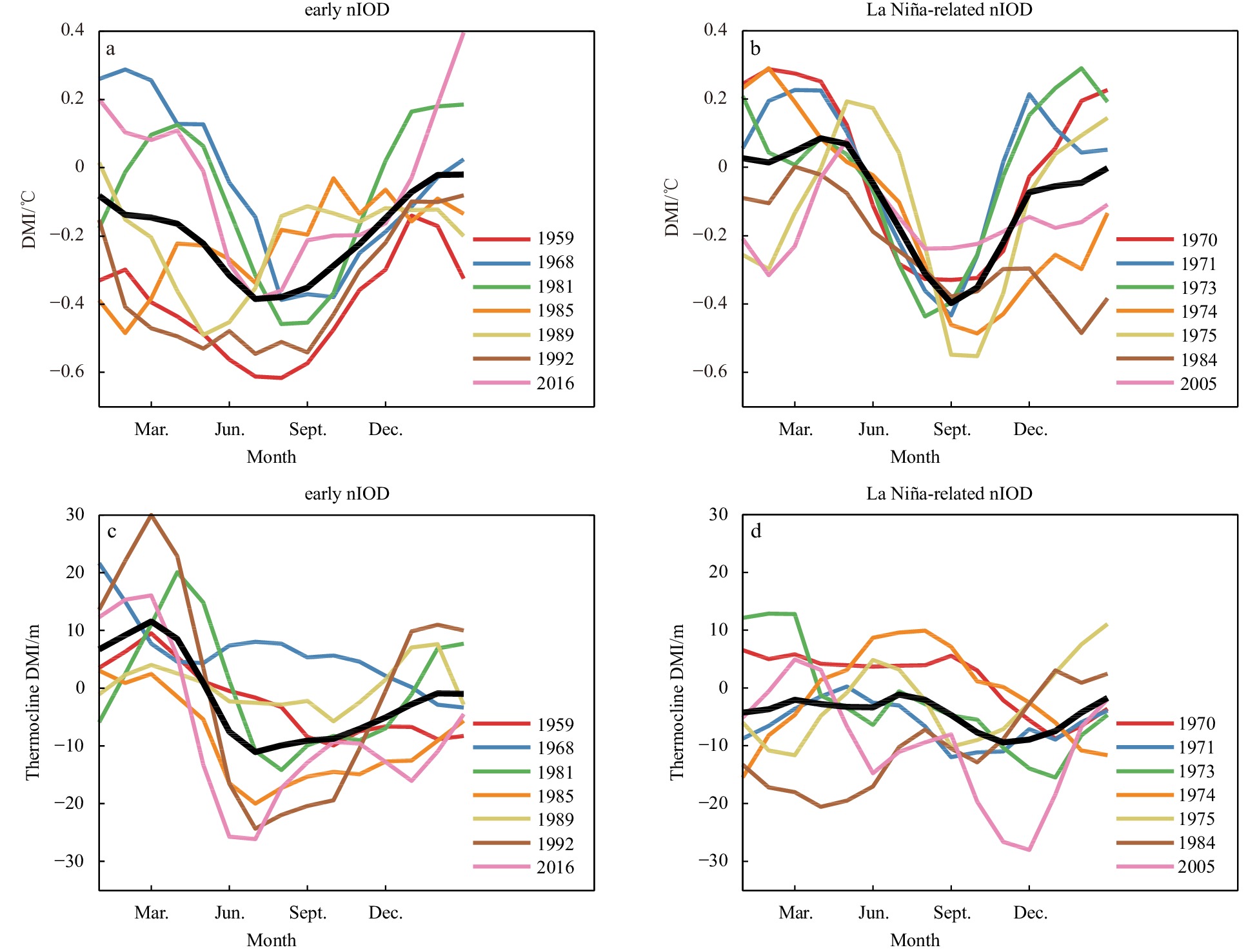
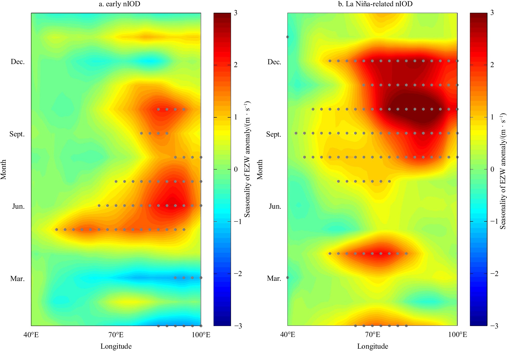
Negative Indian Ocean Dipole (nIOD) can exert great impacts on global climate and can also strongly influence the climate in China. Early nIOD is a major type of nIOD, which can induce more pronounced climate anomalies in summer than La Niña-related nIOD. However, the characteristics and triggering mechanisms of early nIOD are unclear. Our results based on reanalysis datasets indicate that the early nIOD and La Niña-related nIOD are the two major types of nIOD, and the former accounts for over one third of all the nIOD events in the past six decades. These two types of nIODs are similar in their intensities, but are different in their spatial patterns and seasonal cycles. The early nIOD, which develops in spring and peaks in summer, is one season earlier than the La Niña-related nIOD. The spatial pattern of the wind anomaly associated with early nIOD exhibits a winter monsoon-like pattern, with strong westerly anomalies in the equatorial Indian Ocean and eastly anomalies in the northern Indian Ocean. Opposite to the triggering mechanism of early positve IOD, the early nIOD is induced by delayed Indian summer monsoon onset. The results of this study are helpful for improving the prediction skill of IOD and its climate impacts.


Mussel aquaculture and large yellow croaker aquaculture areas and their environmental characteristics in Zhoushan were analyzed using satellite data and in-situ surveys. A new two-step remote sensing method was proposed and applied to determine the basic environmental characteristics of the best mussel and large yellow croaker aquaculture areas. This methodology includes the first step of extraction of the location distribution and the second step of the extraction of internal environmental factors. The fishery ranching index (FRI1, FRI2) was established to extract the mussel and the large yellow croaker aquaculture area in Zhoushan, using Gaofen-1 (GF-1) and Gaofen-6 (GF-6) satellite data with a special resolution of 2 m. In the second step, the environmental factors such as sea surface temperature (SST), chlorophyll a (Chl-a) concentration, current and tide, suspended sediment concentration (SSC) in mussel aquaculture area and large yellow croaker aquaculture area were extracted and analyzed in detail. The results show the following three points. (1) For the extraction of the mussel aquaculture area, FRI1 and FRI2 are complementary, and the combination of FRI1 and FRI2 is suitable to extract the mussel aquaculture area. As for the large yellow croaker aquaculture area extraction, FRI2 is suitable. (2) Mussel aquaculture and the large yellow croaker aquaculture area in Zhoushan are mainly located on the side near the islands that are away from the eastern open waters. The water environment factor template suitable for mussel and large yellow croaker aquaculture was determined. (3) This two-step remote sensing method can be used for the preliminary screening of potential site selection for the mussels and large yellow croaker aquaculture area in the future. the fishery ranching index (FRI1, FRI2) in this paper can be applied to extract the mussel and large yellow croaker aquaculture areas in coastal waters around the world.


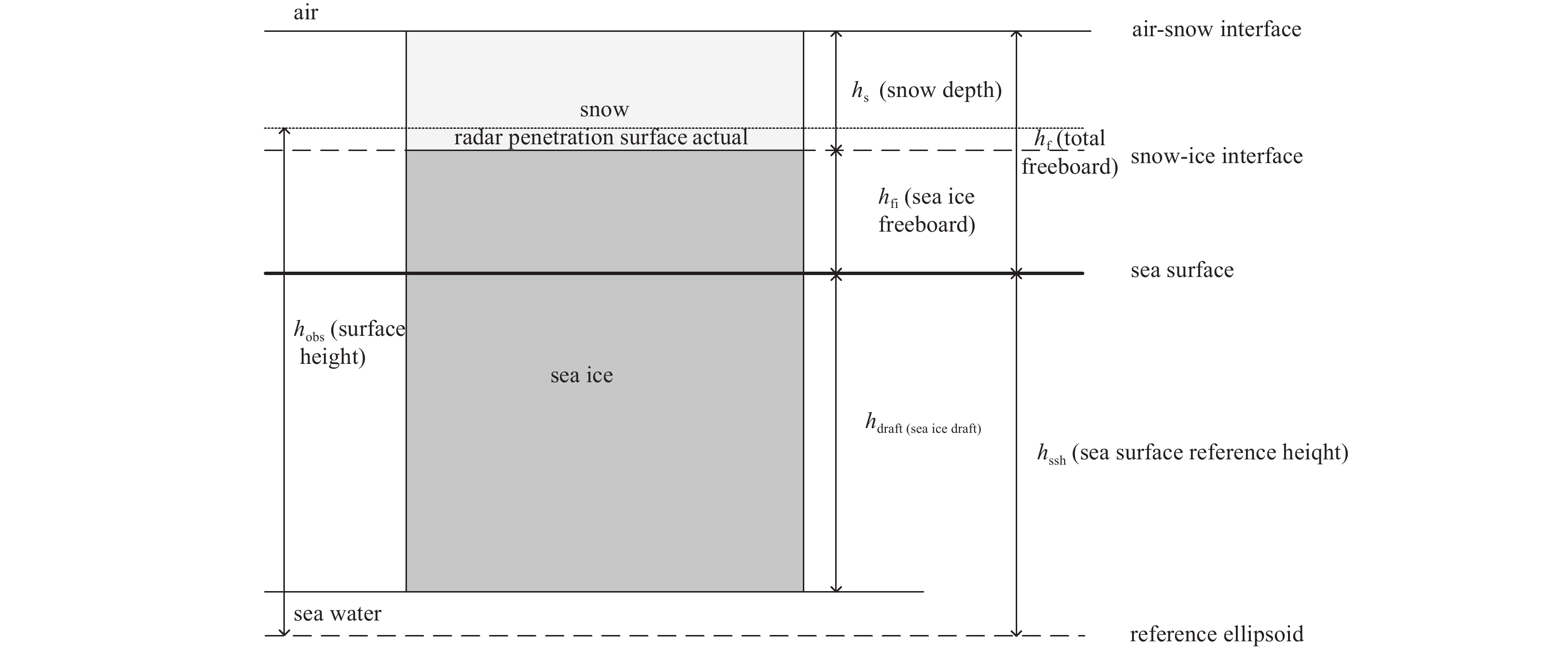
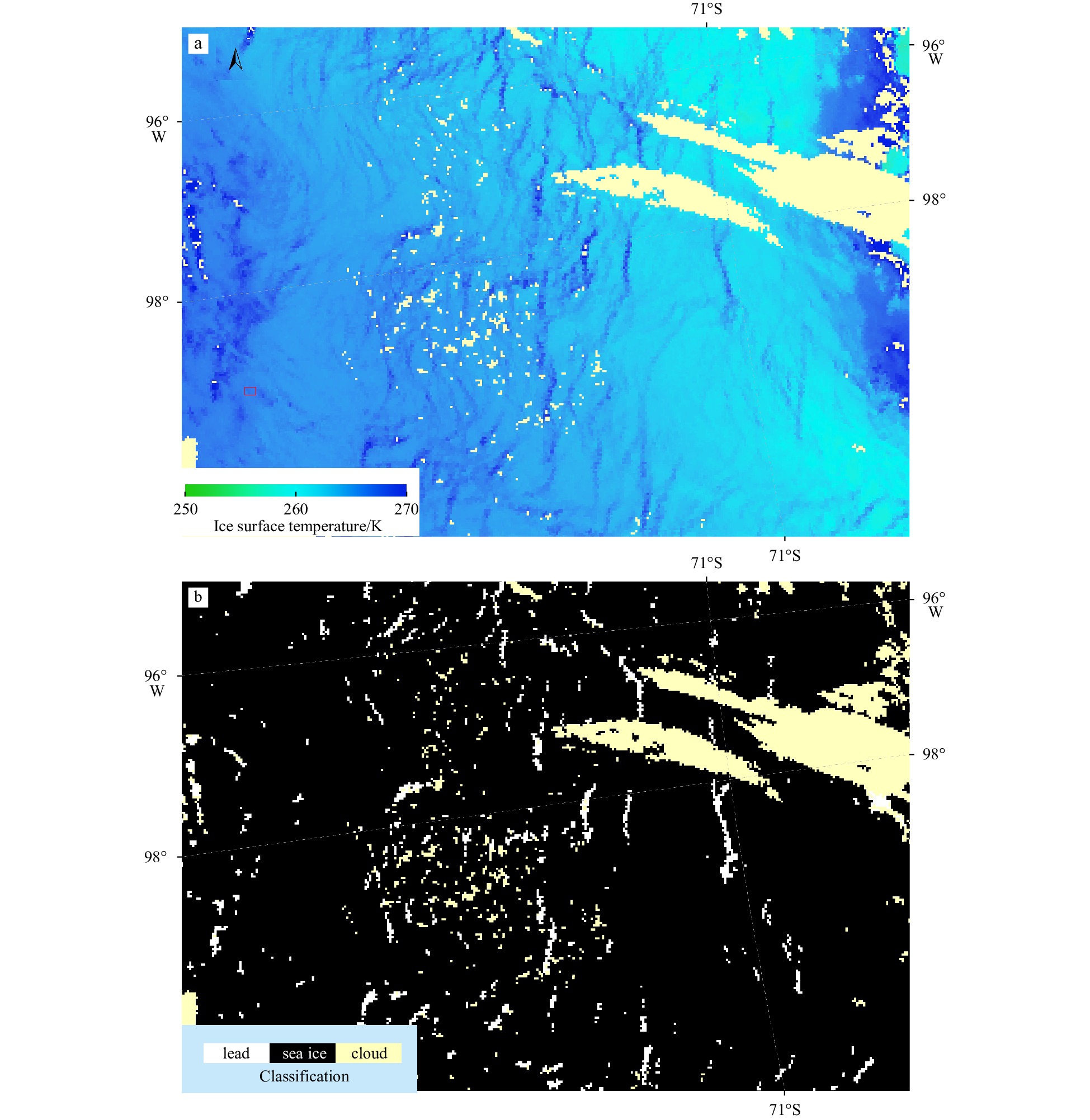
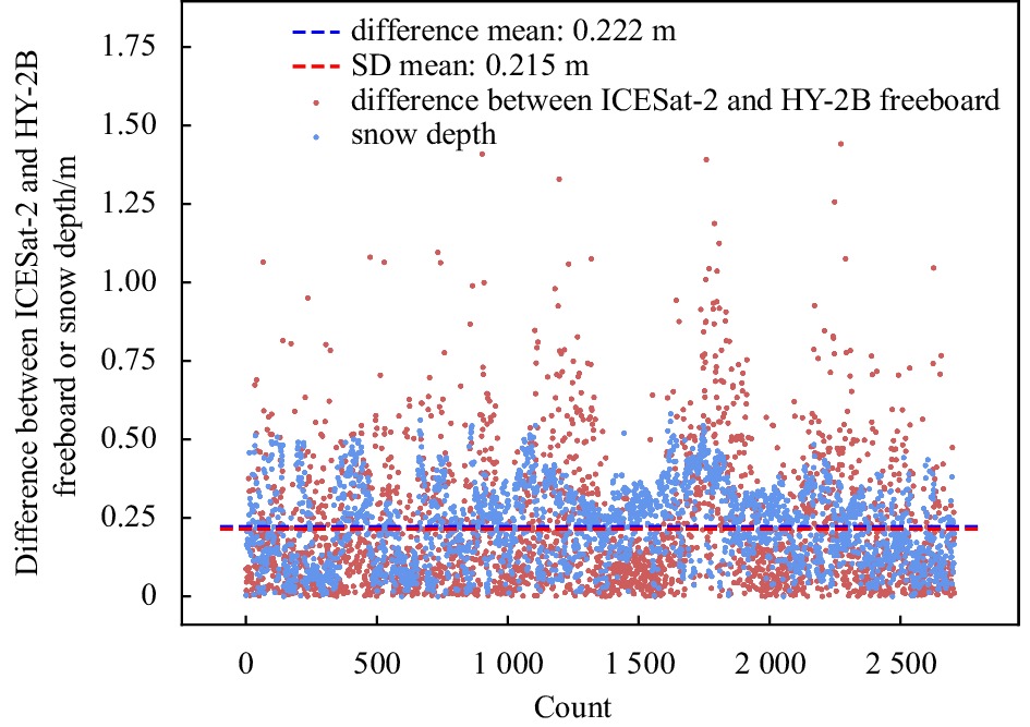
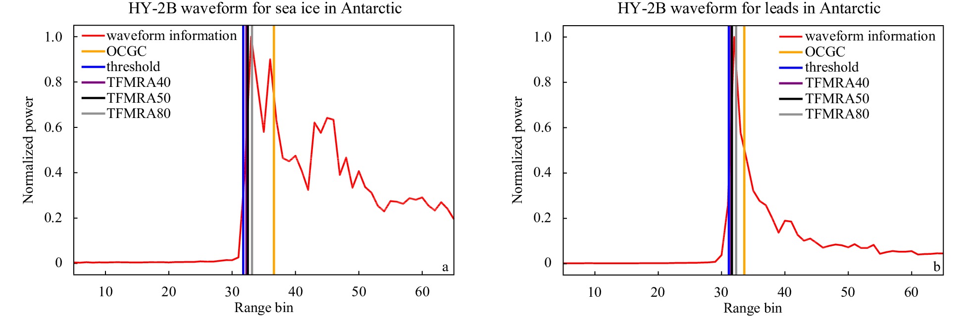
Antarctic sea ice is an important part of the Earth’s atmospheric system, and satellite remote sensing is an important technology for observing Antarctic sea ice. Whether Chinese Haiyang-2B (HY-2B) satellite altimeter data could be used to estimate sea ice freeboard and provide alternative Antarctic sea ice thickness information with a high precision and long time series, as other radar altimetry satellites can, needs further investigation. This paper proposed an algorithm to discriminate leads and then retrieve sea ice freeboard and thickness from HY-2B radar altimeter data. We first collected the Moderate-resolution Imaging Spectroradiometer ice surface temperature (IST) product from the National Aeronautics and Space Administration to extract leads from the Antarctic waters and verified their accuracy through Sentinel-1 Synthetic Aperture Radar images. Second, a surface classification decision tree was generated for HY-2B satellite altimeter measurements of the Antarctic waters to extract leads and calculate local sea surface heights. We then estimated the Antarctic sea ice freeboard and thickness based on local sea surface heights and the static equilibrium equation. Finally, the retrieved HY-2B Antarctic sea ice thickness was compared with the CryoSat-2 sea ice thickness and the Antarctic Sea Ice Processes and Climate (ASPeCt) ship-based observed sea ice thickness. The results indicate that our classification decision tree constructed for HY-2B satellite altimeter measurements was reasonable, and the root mean square error of the obtained sea ice thickness compared to the ship measurements was 0.62 m. The proposed sea ice thickness algorithm for the HY-2B radar satellite fills a gap in this application domain for the HY-series satellites and can be a complement to existing Antarctic sea ice thickness products; this algorithm could provide long-time-series and large-scale sea ice thickness data that contribute to research on global climate change.


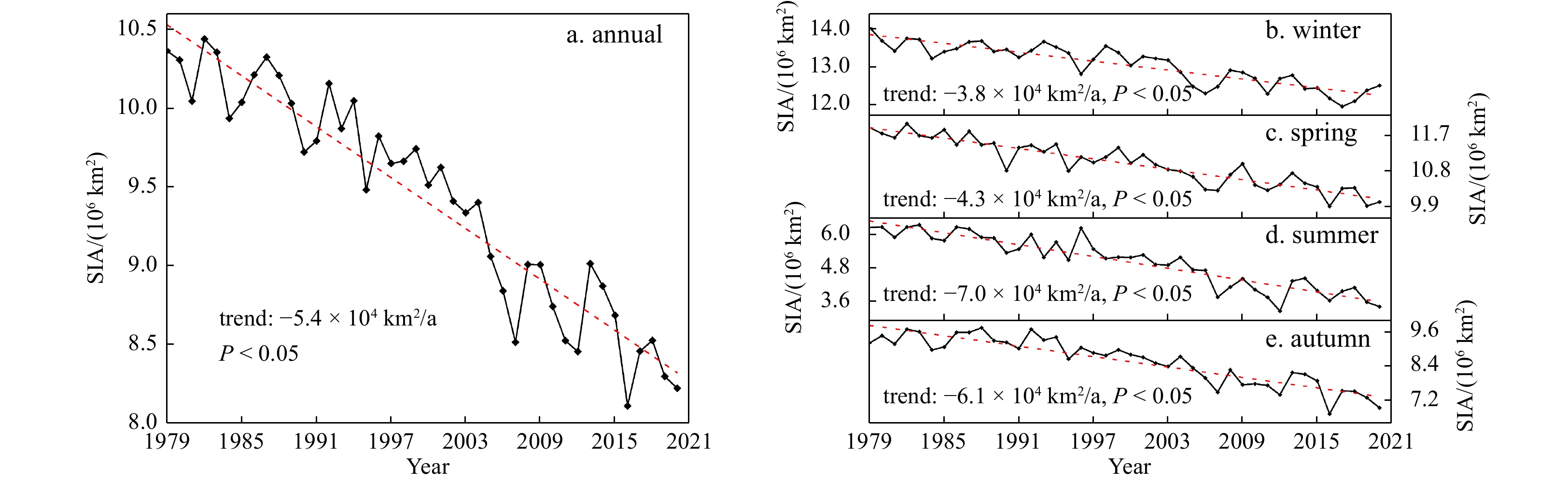
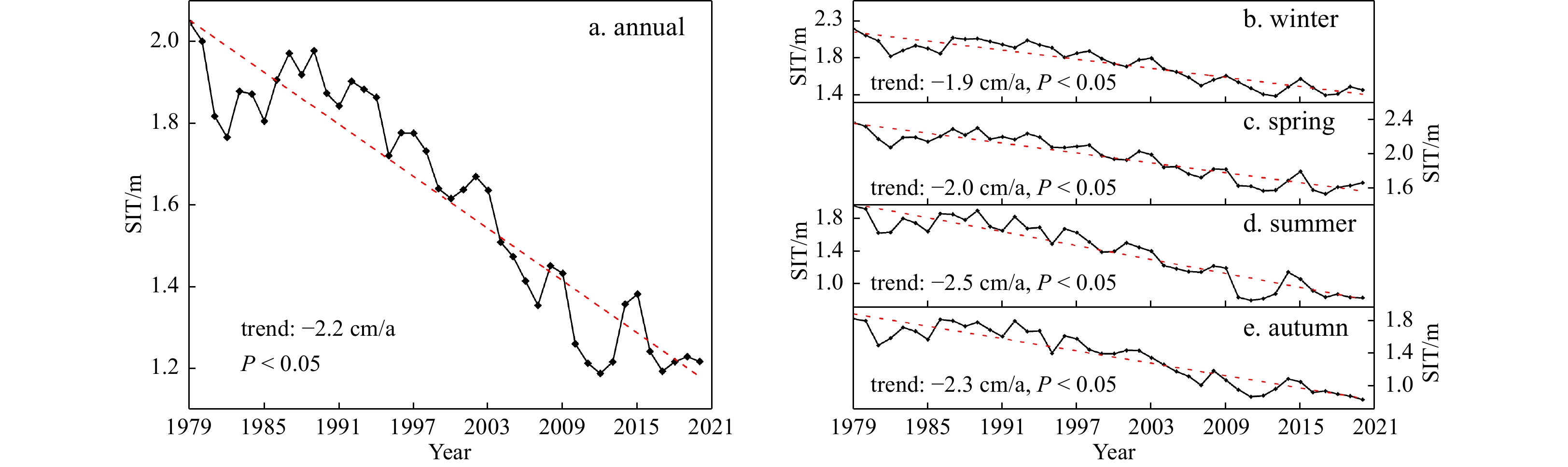
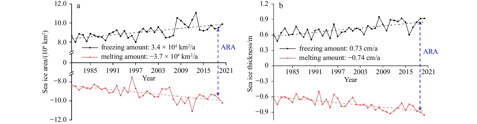
Arctic sea ice is broadly regarded as an indicator and amplifier of global climate change. The rapid changes in Arctic sea ice have been widely concerned. However, the spatiotemporal changes in the horizontal and vertical dimensions of Arctic sea ice and its asymmetry during the melt and freeze seasons are rarely quantified simultaneously based on multiple sources of the same long time series. In this study, the spatiotemporal variation and freeze-thaw asymmetry of Arctic sea ice were investigated from both the horizontal and vertical dimensions during 1979–2020 based on remote sensing and assimilation data. The results indicated that Arctic sea ice was declining at a remarkably high rate of –5.4 × 10⁴ km2/a in sea ice area (SIA) and –2.2 cm/a in sea ice thickness (SIT) during 1979 to 2020, and the reduction of SIA and SIT was the largest in summer and the smallest in winter. Spatially, compared with other sub-regions, SIA showed a sharper declining trend in the Barents Sea, Kara Sea, and East Siberian Sea, while SIT presented a larger downward trend in the northern Canadian Archipelago, northern Greenland, and the East Siberian Sea. Regarding to the seasonal trend of sea ice on sub-region scale, the reduction rate of SIA exhibited an apparent spatial heterogeneity among seasons, especially in summer and winter, i.e., the sub-regions linked to the open ocean exhibited a higher decline rate in winter; however, the other sub-regions blocked by the coastlines presented a greater decline rate in summer. For SIT, the sub-regions such as the Beaufort Sea, East Siberian Sea, Chukchi Sea, Central Arctic, and Canadian Archipelago always showed a higher downward rate in all seasons. Furthermore, a striking freeze-thaw asymmetry of Arctic sea ice was also detected. Comparing sea ice changes in different dimensions, sea ice over most regions in the Arctic showed an early retreat and rapid advance in the horizontal dimension but late melting and gradual freezing in the vertical dimension. The amount of sea ice melting and freezing was disequilibrium in the Arctic during the considered period, and the rate of sea ice melting was 0.3 × 10⁴ km2/a and 0.01 cm/a higher than that of freezing in the horizontal and vertical dimensions, respectively. Moreover, there were notable shifts in the melting and freezing of Arctic sea ice in 1997/2003 and 2000/2004, respectively, in the horizontal/vertical dimension.


To effectively extract multi-scale information from observation data and improve computational efficiency, a multi-scale second-order autoregressive recursive filter (MSRF) method is designed. The second-order autoregressive filter used in this study has been attempted to replace the traditional first-order recursive filter used in spatial multi-scale recursive filter (SMRF) method. The experimental results indicate that the MSRF scheme successfully extracts various scale information resolved by observations. Moreover, compared with the SMRF scheme, the MSRF scheme improves computational accuracy and efficiency to some extent. The MSRF scheme can not only propagate to a longer distance without the attenuation of innovation, but also reduce the mean absolute deviation between the reconstructed sea ice concentration results and observations reduced by about 3.2 % compared to the SMRF scheme. On the other hand, compared with traditional first-order recursive filters using in the SMRF scheme that multiple filters are executed, the MSRF scheme only needs to perform two filter processes in one iteration, greatly improving filtering efficiency. In the two-dimensional experiment of sea ice concentration, the calculation time of the MSRF scheme is only 1/7 of that of SMRF scheme. This means that the MSRF scheme can achieve better performance with less computational cost, which is of great significance for further application in real-time ocean or sea ice data assimilation systems in the future.


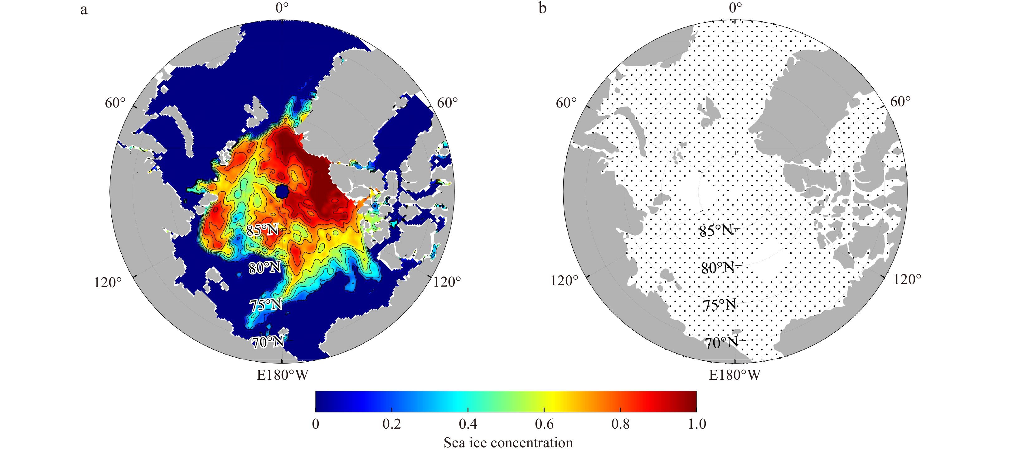


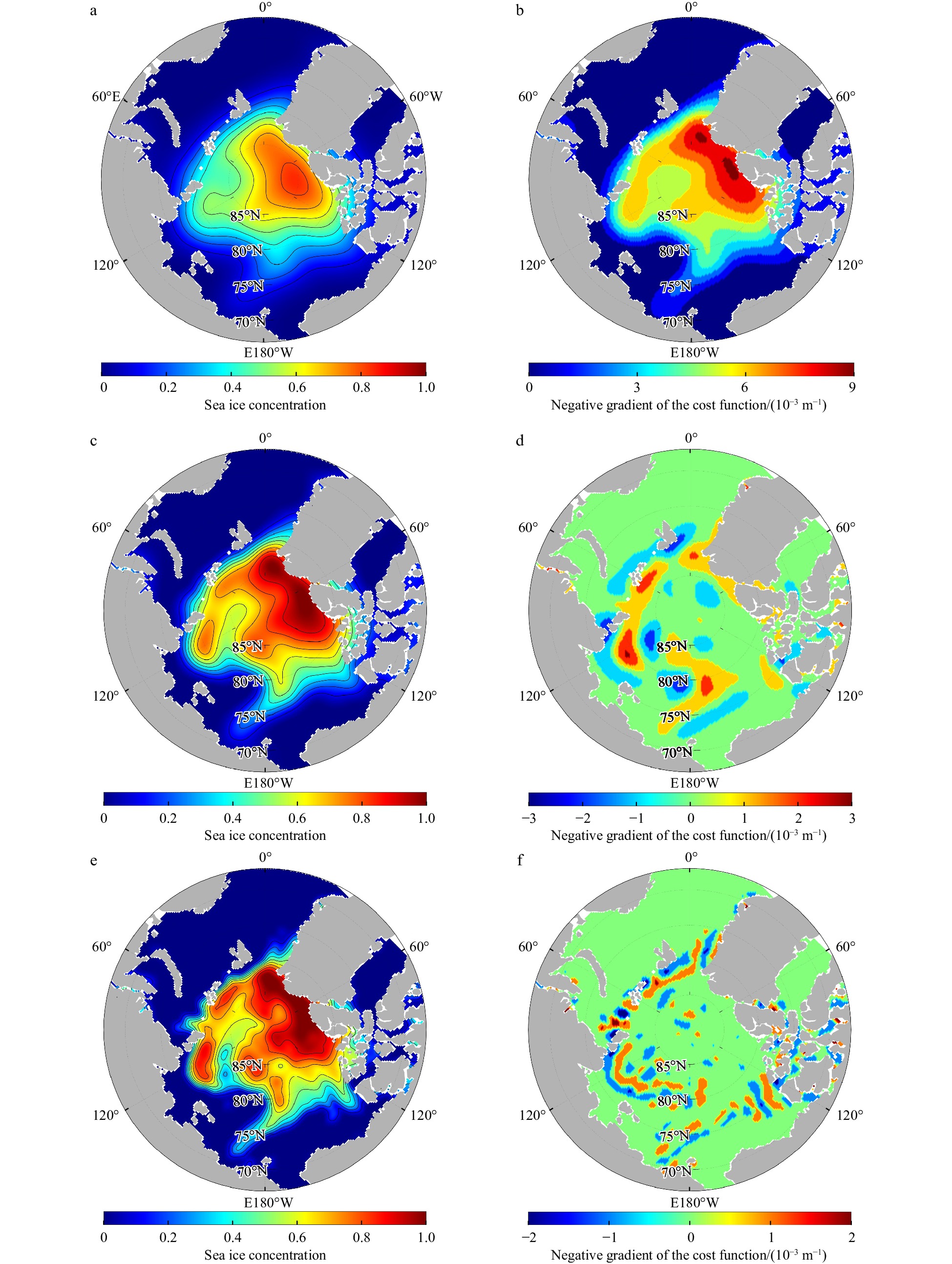


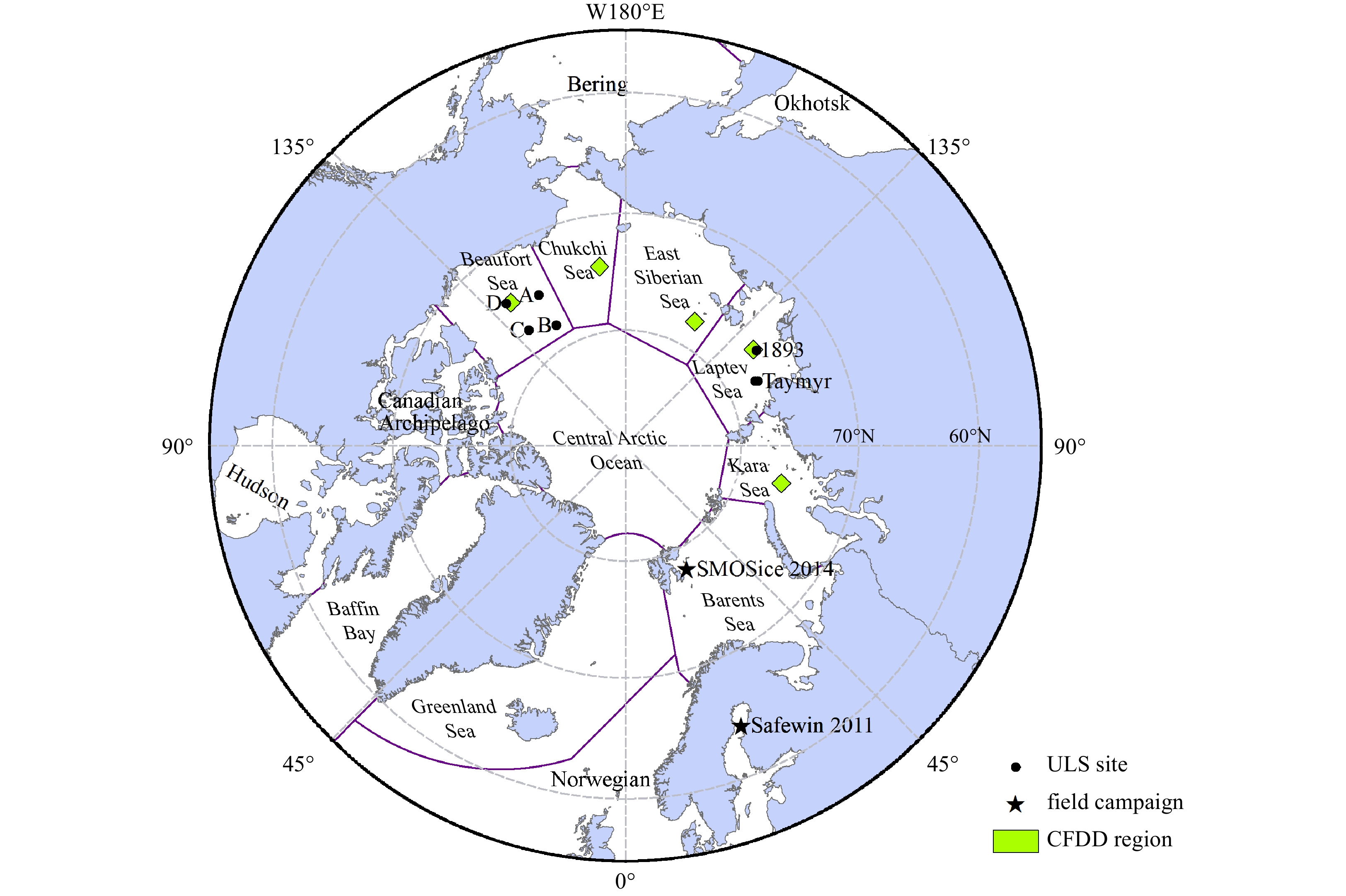
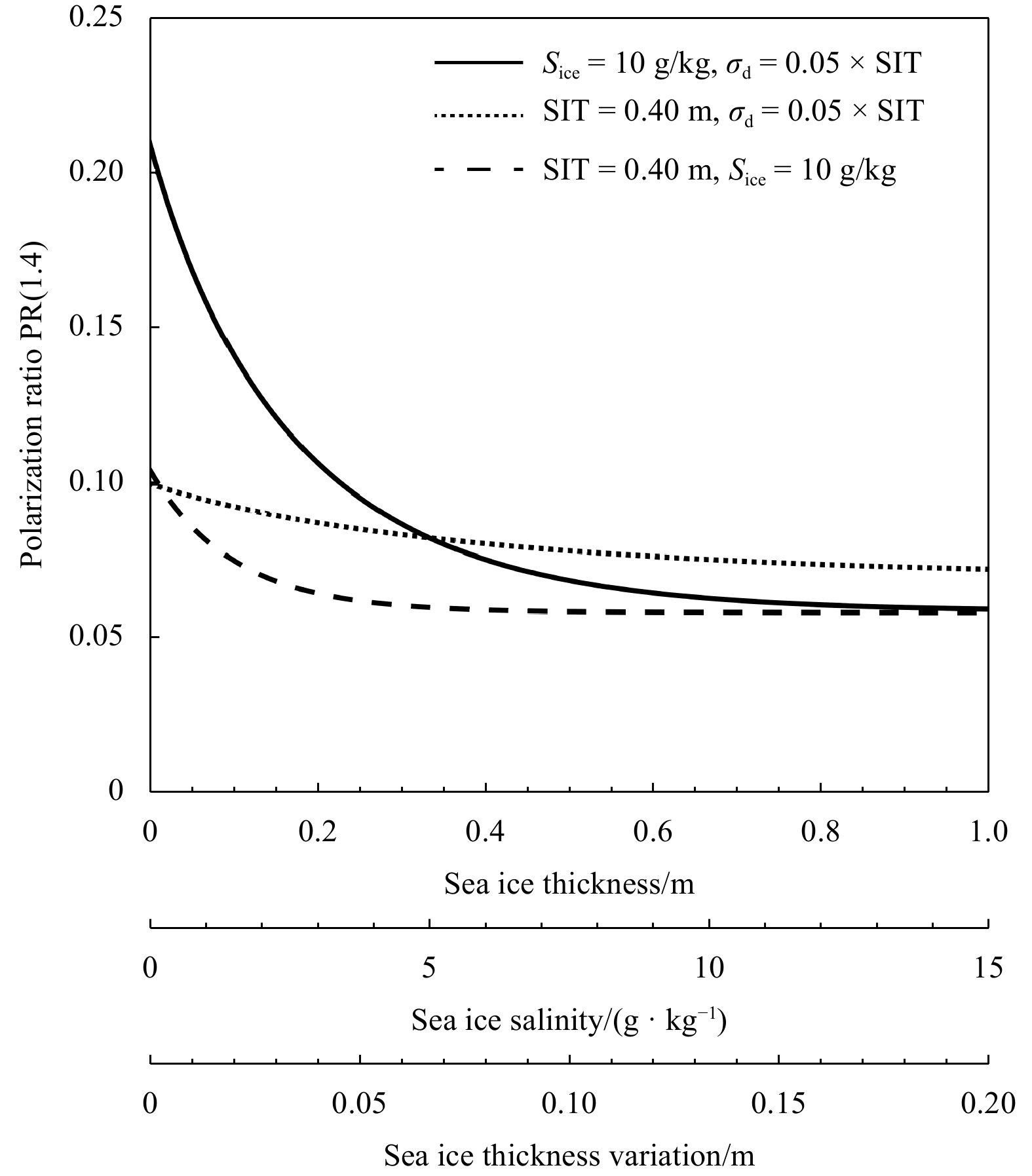
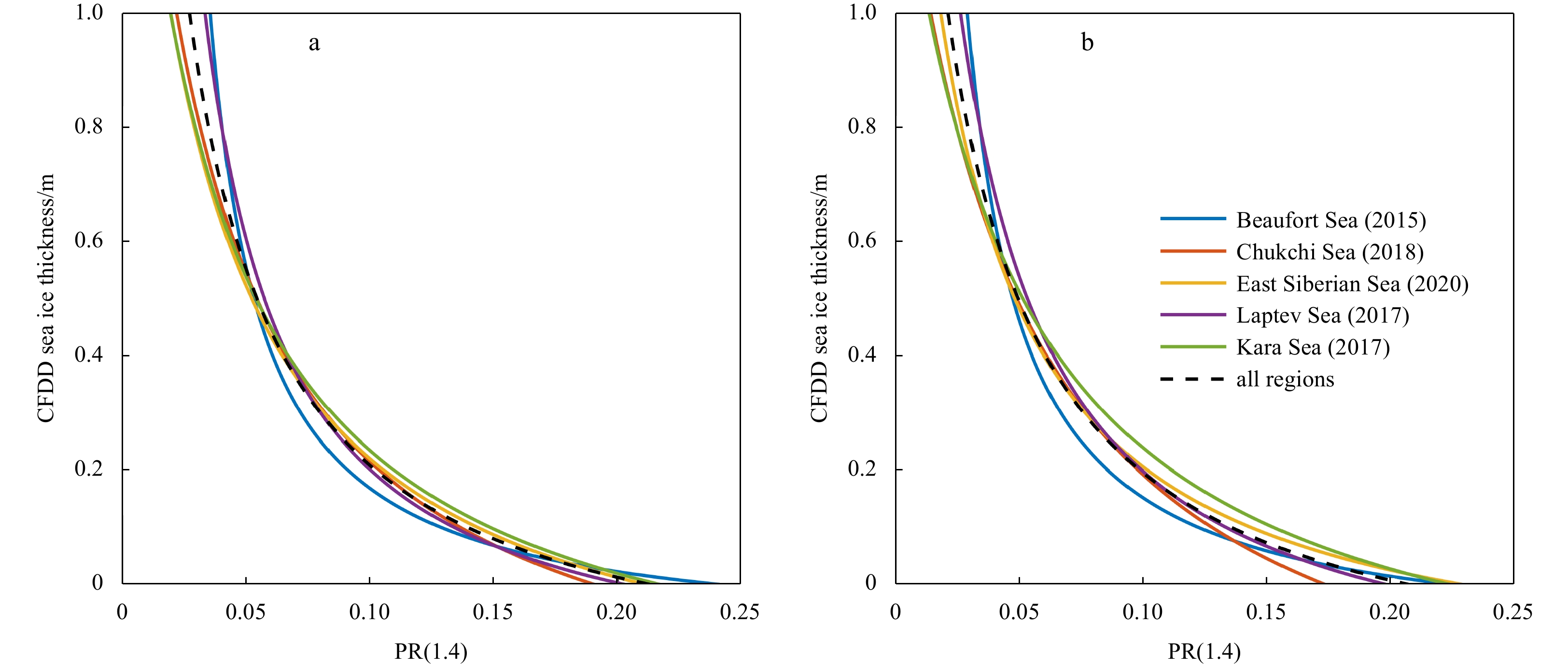
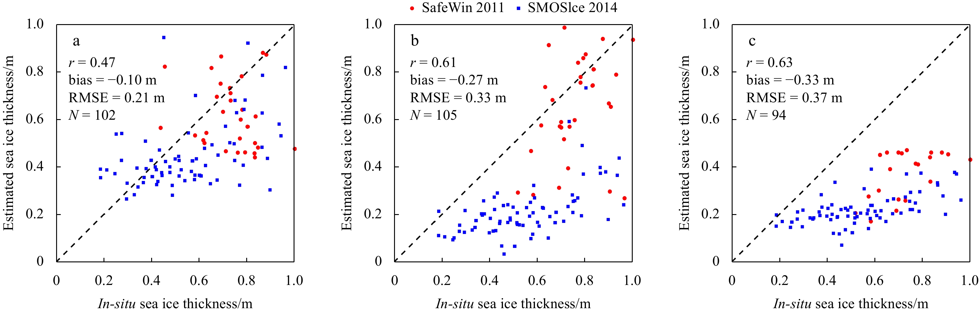
The aim of this study was to develop an improved thin sea ice thickness (SIT) retrieval algorithm in the Arctic Ocean from the Soil Moisture Ocean Salinity and Soil Moisture Active Passive L-band radiometer data. This SIT retrieval algorithm was trained using the simulated SIT from the cumulative freezing degree days model during the freeze-up period over five carefully selected regions in the Beaufort, Chukchi, East Siberian, Laptev and Kara seas and utilized the microwave polarization ratio (PR) at incidence angle of 40°. The improvements of the proposed retrieval algorithm include the correction for the sea ice concentration impact, reliable reference SIT data over different representative regions of the Arctic Ocean and the utilization of microwave polarization ratio that is independent of ice temperature. The relationship between the SIT and PR was found to be almost stable across the five selected regions. The SIT retrievals were then compared to other two existing algorithms (i.e., UH_SIT from the University of Hamburg and UB_SIT from the University of Bremen) and validated against independent SIT data obtained from moored upward looking sonars (ULS) and airborne electromagnetic (EM) induction sensors. The results suggest that the proposed algorithm could achieve comparable accuracies to UH_SIT and UB_SIT with root mean square error (RMSE) being about 0.20 m when validating using ULS SIT data and outperformed the UH_SIT and UB_SIT with RMSE being about 0.21 m when validatng using EM SIT data. The proposed algorithm can be used for thin sea ice thickness (<1.0 m) estimation in the Arctic Ocean and requires less auxiliary data in the SIT retrieval procedure which makes its implementation more practical.


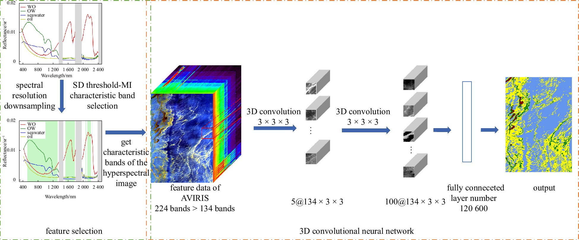
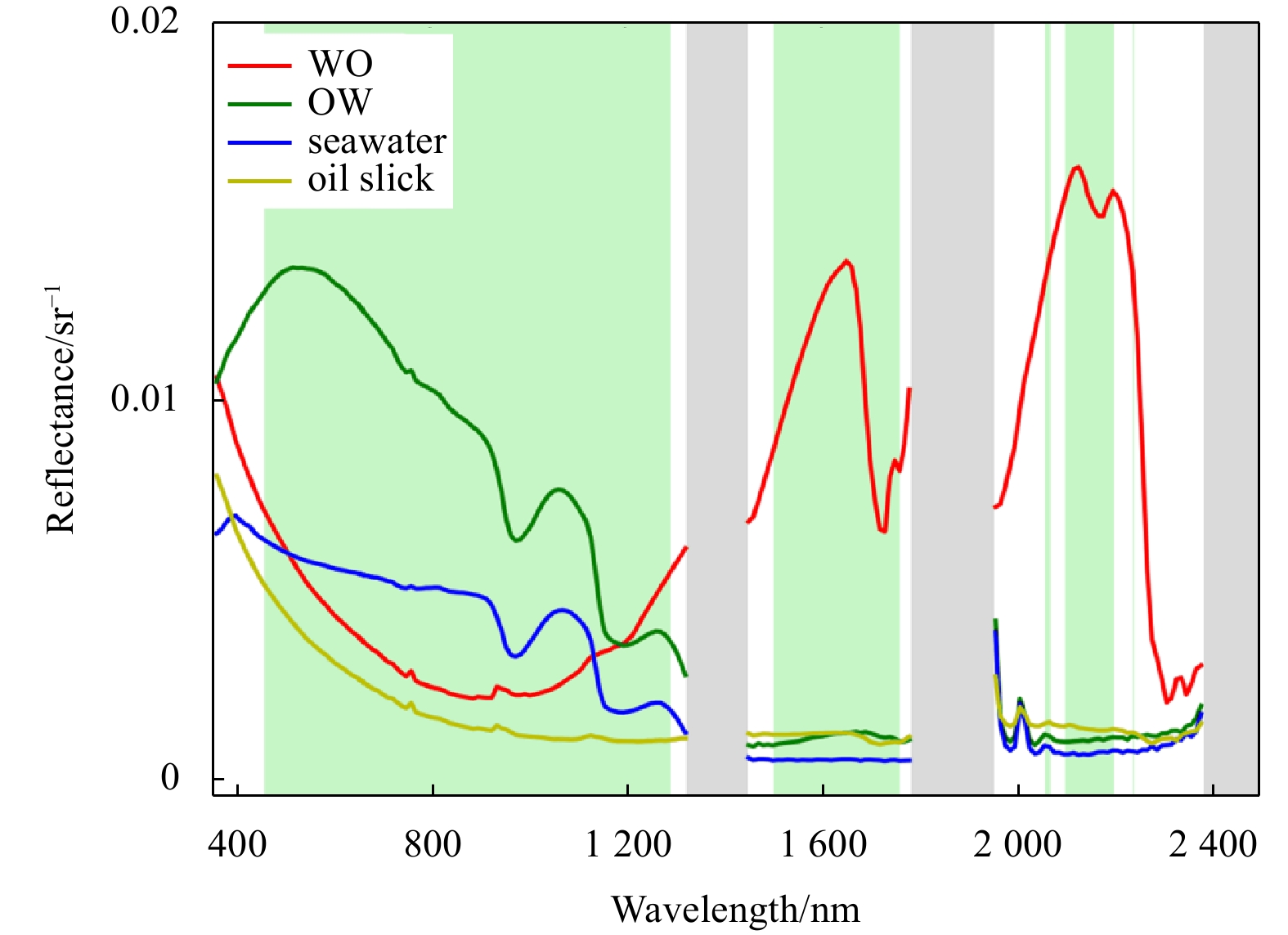
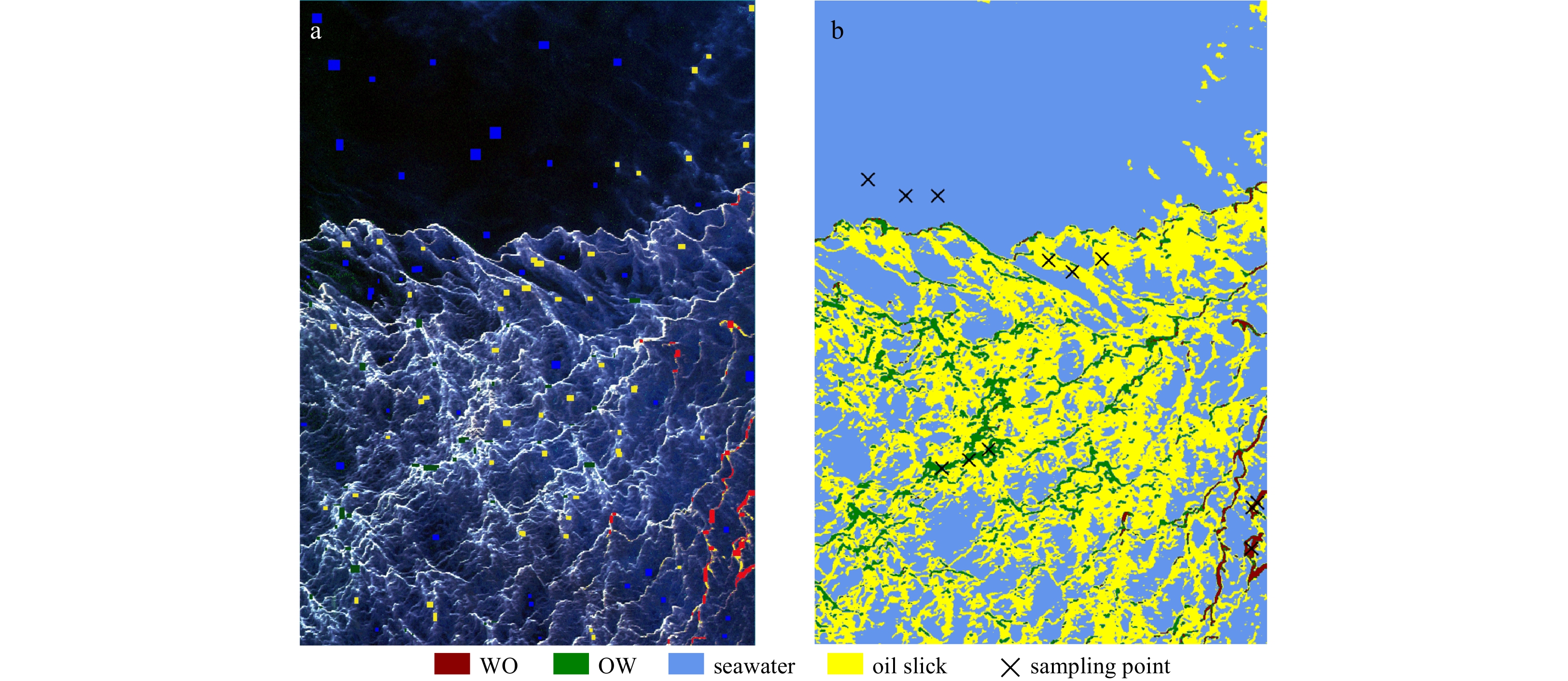
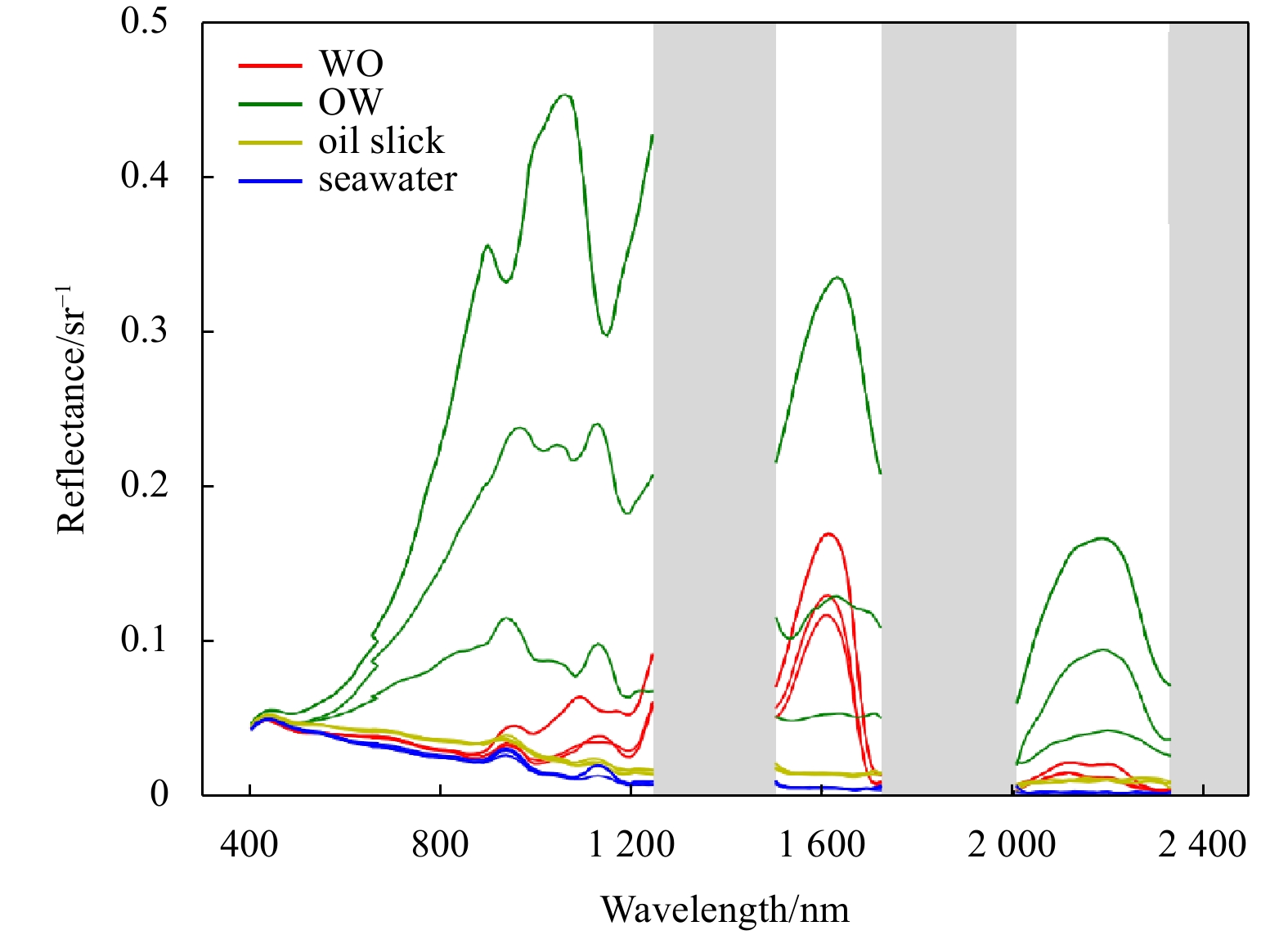
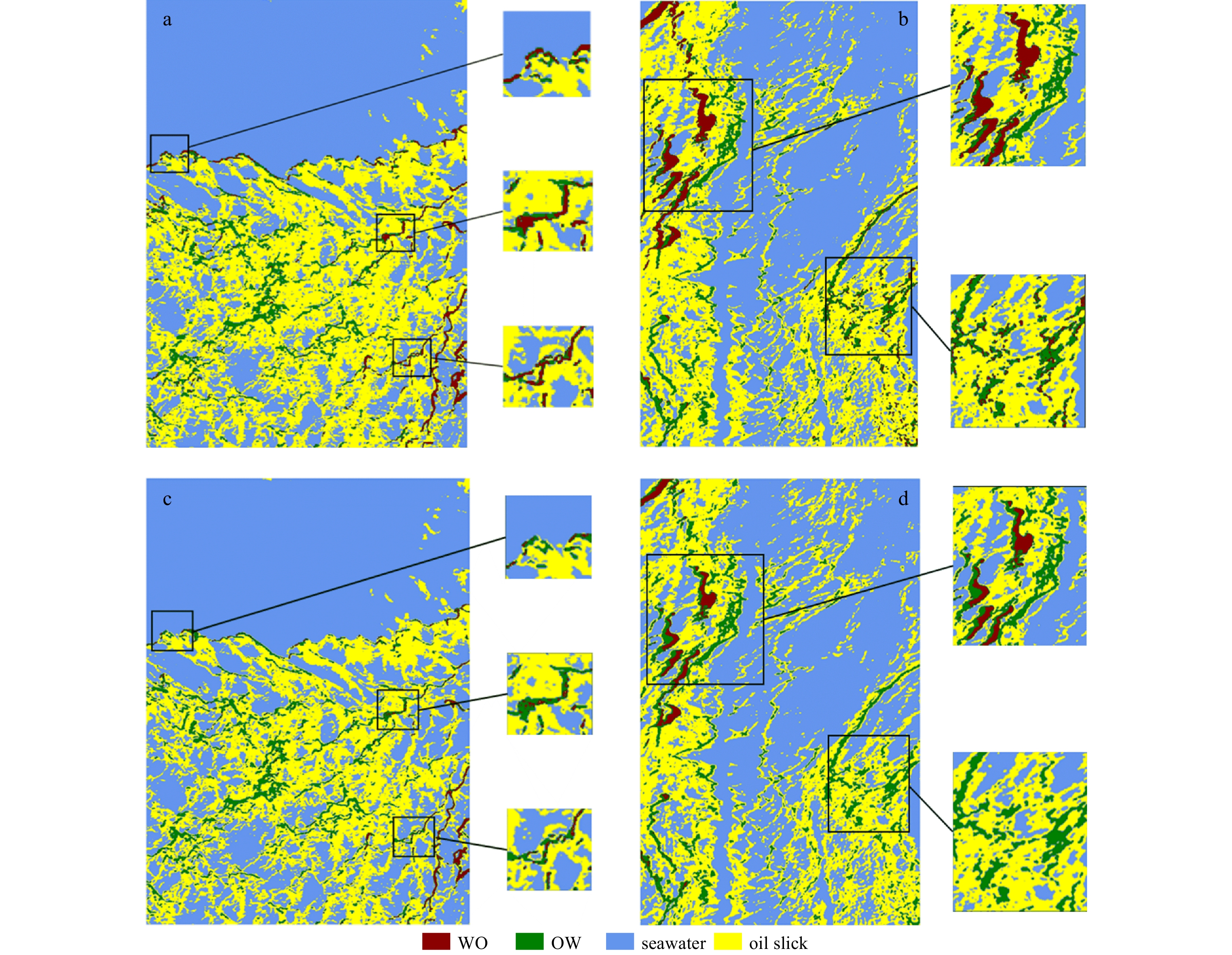
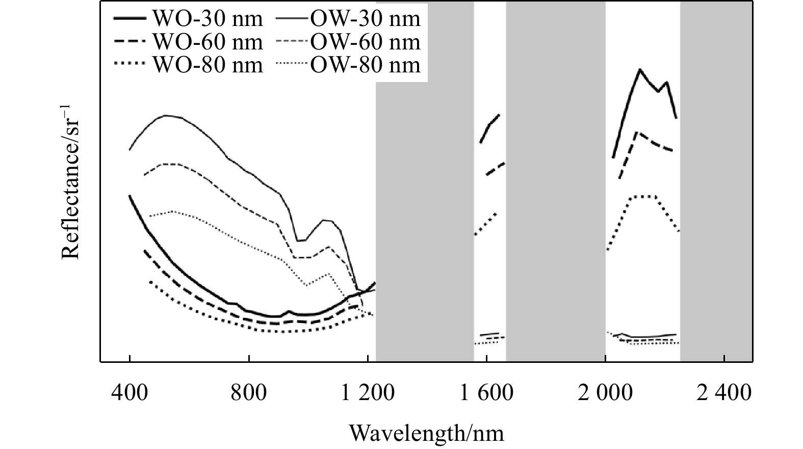
Marine oil spill emulsions are difficult to recover, and the damage to the environment is not easy to eliminate. The use of remote sensing to accurately identify oil spill emulsions is highly important for the protection of marine environments. However, the spectrum of oil emulsions changes due to different water content. Hyperspectral remote sensing and deep learning can use spectral and spatial information to identify different types of oil emulsions. Nonetheless, hyperspectral data can also cause information redundancy, reducing classification accuracy and efficiency, and even overfitting in machine learning models. To address these problems, an oil emulsion deep-learning identification model with spatial-spectral feature fusion is established, and feature bands that can distinguish between crude oil, seawater, water-in-oil emulsion (WO), and oil-in-water emulsion (OW) are filtered based on a standard deviation threshold–mutual information method. Using oil spill airborne hyperspectral data, we conducted identification experiments on oil emulsions in different background waters and under different spatial and temporal conditions, analyzed the transferability of the model, and explored the effects of feature band selection and spectral resolution on the identification of oil emulsions. The results show the following. (1) The standard deviation–mutual information feature selection method is able to effectively extract feature bands that can distinguish between WO, OW, oil slick, and seawater. The number of bands was reduced from 224 to 134 after feature selection on the Airborne Visible Infrared Imaging Spectrometer (AVIRIS) data and from 126 to 100 on the S185 data. (2) With feature selection, the overall accuracy and Kappa of the identification results for the training area are 91.80% and 0.86, respectively, improved by 2.62% and 0.04, and the overall accuracy and Kappa of the identification results for the migration area are 86.53% and 0.80, respectively, improved by 3.45% and 0.05. (3) The oil emulsion identification model has a certain degree of transferability and can effectively identify oil spill emulsions for AVIRIS data at different times and locations, with an overall accuracy of more than 80%, Kappa coefficient of more than 0.7, and F1 score of 0.75 or more for each category. (4) As the spectral resolution decreasing, the model yields different degrees of misclassification for areas with a mixed distribution of oil slick and seawater or mixed distribution of WO and OW. Based on the above experimental results, we demonstrate that the oil emulsion identification model with spatial–spectral feature fusion achieves a high accuracy rate in identifying oil emulsion using airborne hyperspectral data, and can be applied to images under different spatial and temporal conditions. Furthermore, we also elucidate the impact of factors such as spectral resolution and background water bodies on the identification process. These findings provide new reference for future endeavors in automated marine oil spill detection.


Latest Issues
ISSN 0253-505X (Print)
0253-505X (Online)
CN 11-2056/P
ISSN 0253-505X
CN 11-2056/P
ISSN 0253-505X (Print)
0253-505X (Online)
CN 11-2056/P
ISSN 0253-505X
CN 11-2056/P
ISSN 0253-505X (Print)
0253-505X (Online)
CN 11-2056/P
ISSN 0253-505X
CN 11-2056/P
ISSN 0253-505X (Print)
0253-505X (Online)
CN 11-2056/P
ISSN 0253-505X
CN 11-2056/P

ISSN 0253-505X (Print)
0253-505X (Online)
CN 11-2056/P
ISSN 0253-505X
CN 11-2056/P

ISSN 0253-505X (Print)
0253-505X (Online)
CN 11-2056/P
ISSN 0253-505X
CN 11-2056/P


