
2023 Vol. 42, No. 5
Display Method:
2023, 42(5): 1-13.
doi: 10.1007/s13131-022-2085-2
Abstract:
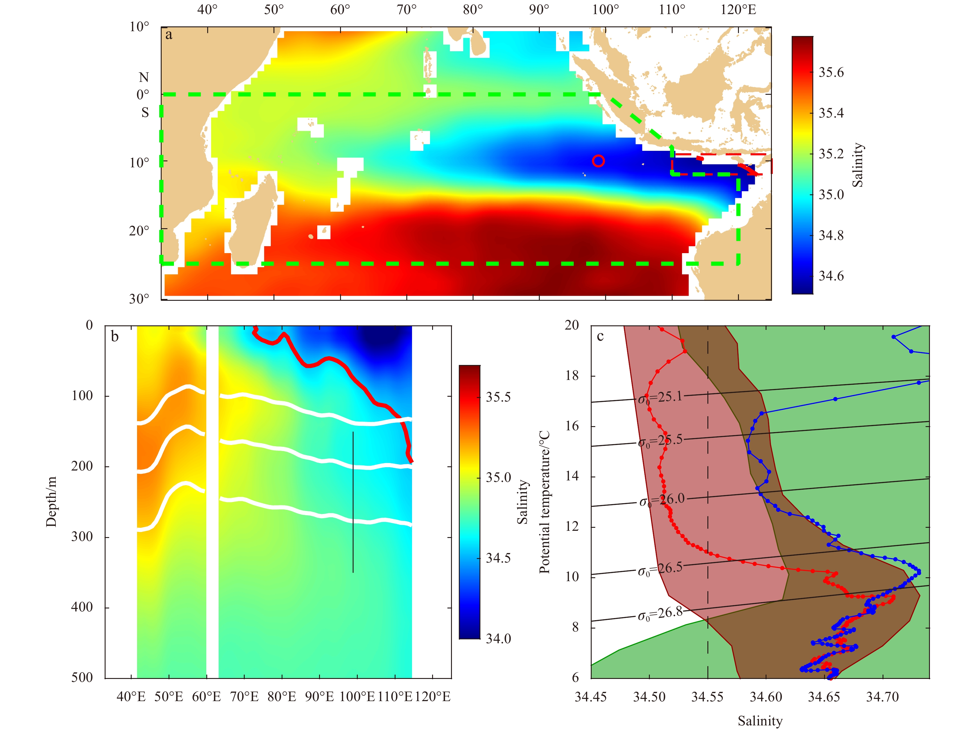
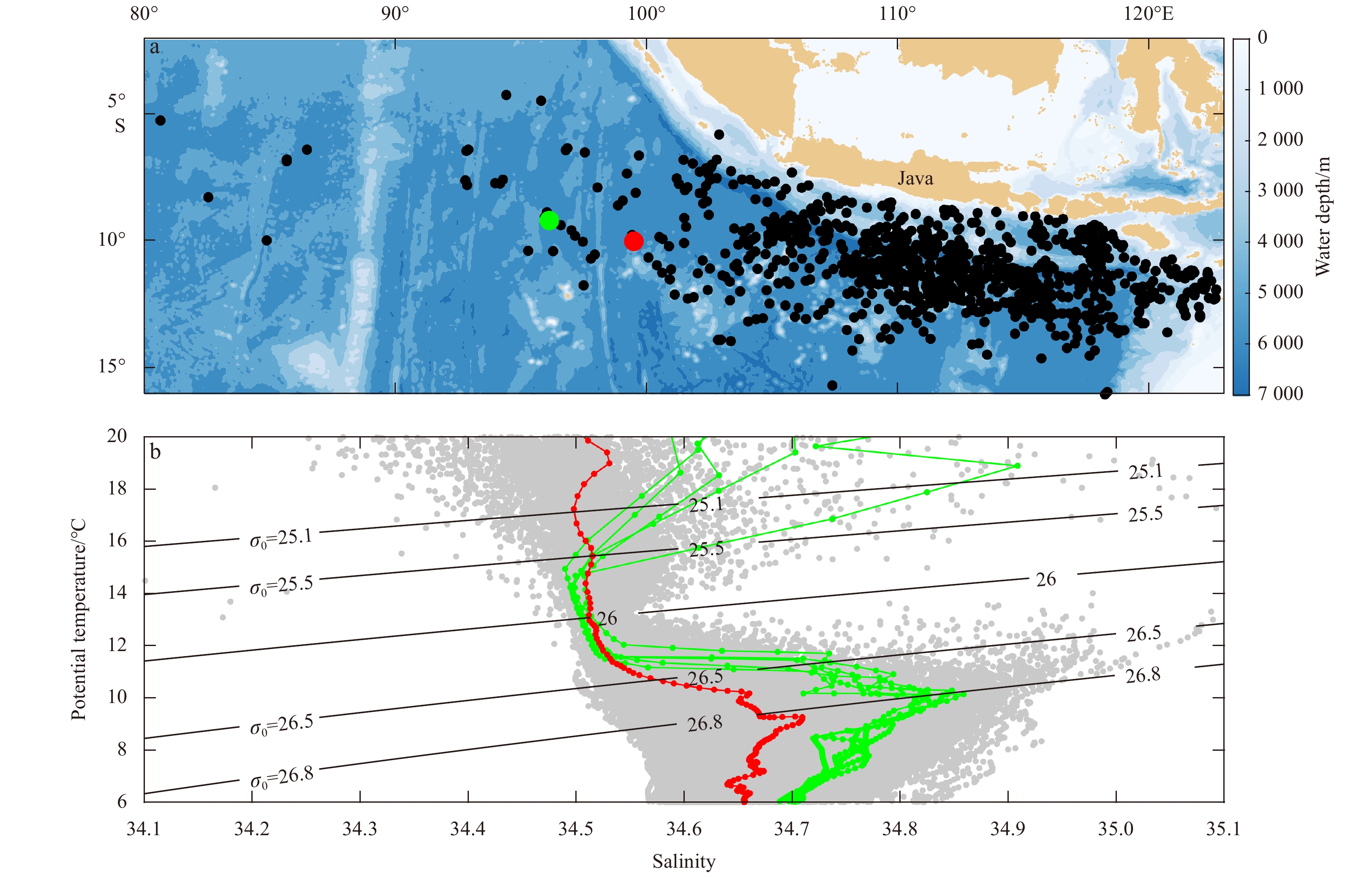
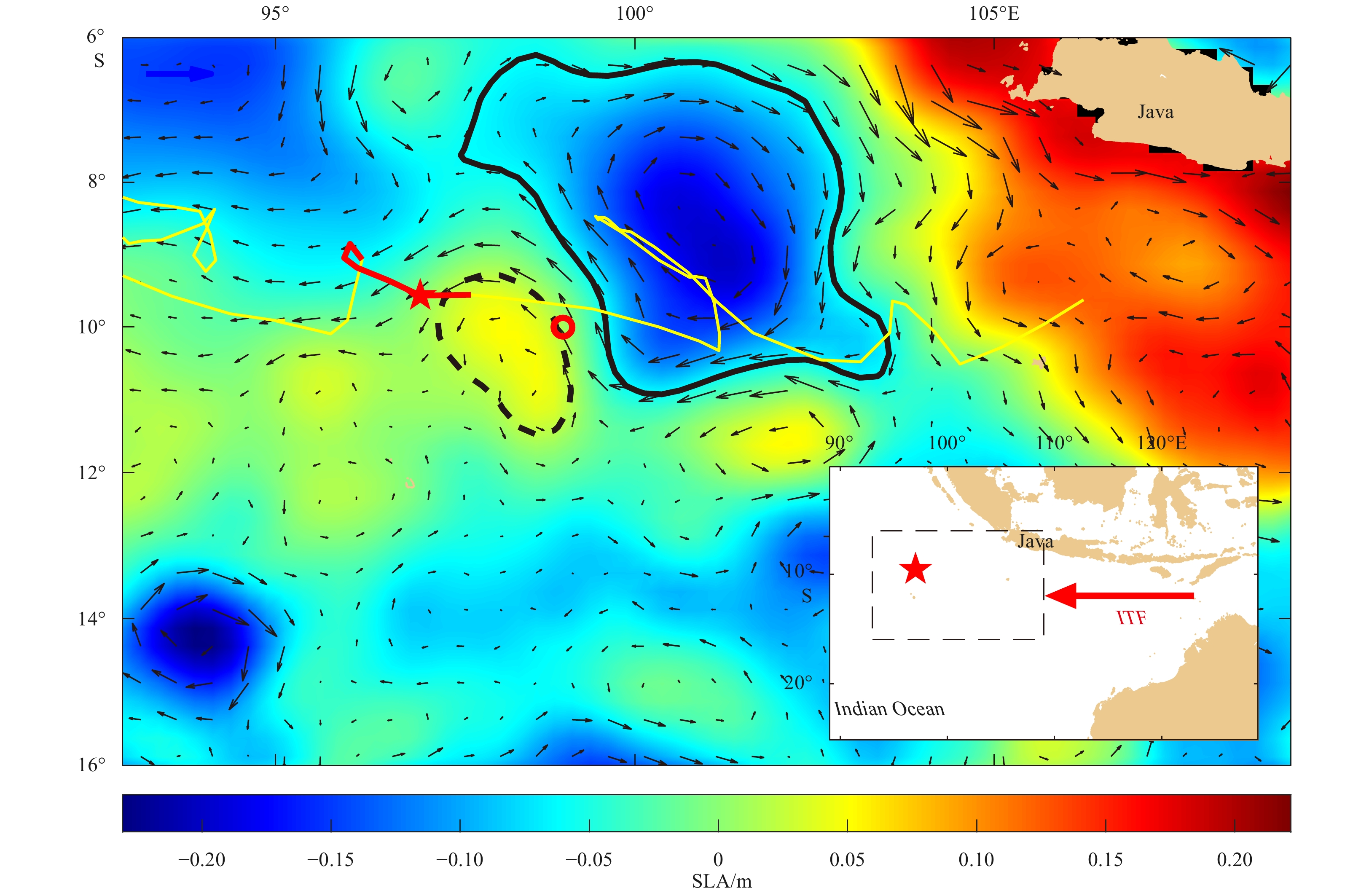
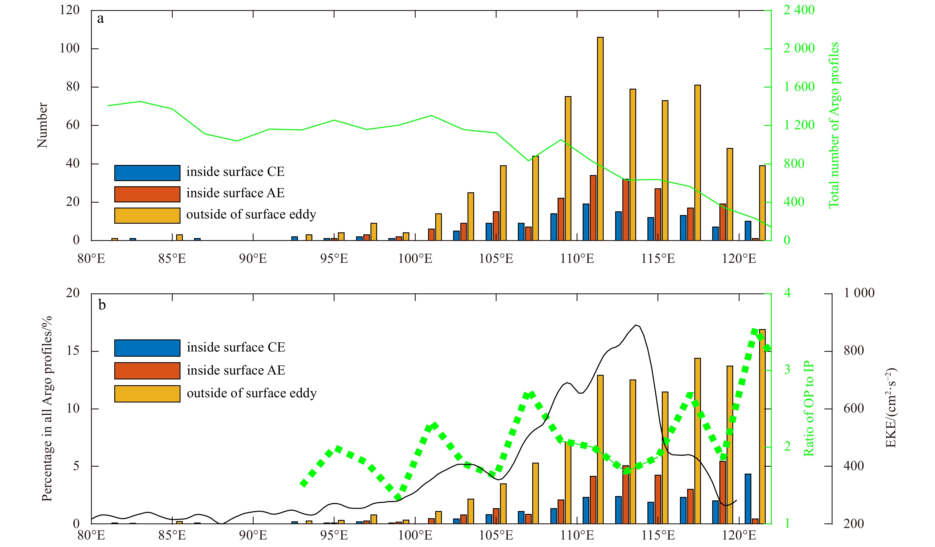
We observed a subthermocline eddy (STE) with a cold and fresh core during an observation cruise along a transect of 10°S in the southeastern tropical Indian Ocean (SETIO) in December 2017. The vertical scale, speed radius, and maximum swirl velocity of the STE were about 200 m, 55 km, and 0.5 m/s, respectively. The mean Rossby number and Burger number of the STE were then estimated to be about −0.7 and 2.4, indicating the STE was a submesoscale coherent vortex. The STE core water had characteristics of the Indonesian Throughflow (ITF) water and was distinct from that of surrounding areas. By examining Argo float data, another STE was well captured by five successive profiles of the same Argo float. Both STEs showed significant temperature and salinity anomalies at the σ0=26.0–26.5 kg/m3 surfaces. With the assumption that the low-salinity ITF water parcels could be carried only by surface eddies and the STEs, the Argo profiles, which detected low-salinity ITF water and were located outside a surface eddy, were believed to be inside an STE and were used to analyze the distribution, origin, and generation mechanism of the STE. The results suggested that the STEs carrying ITF water may be generated under topography-current interaction at the eastern coastal waters or under front-induced subduction in the area away from coastal waters. Those STEs may be widely distributed in the SETIO and may play a role in ITF water parcel transport.
We observed a subthermocline eddy (STE) with a cold and fresh core during an observation cruise along a transect of 10°S in the southeastern tropical Indian Ocean (SETIO) in December 2017. The vertical scale, speed radius, and maximum swirl velocity of the STE were about 200 m, 55 km, and 0.5 m/s, respectively. The mean Rossby number and Burger number of the STE were then estimated to be about −0.7 and 2.4, indicating the STE was a submesoscale coherent vortex. The STE core water had characteristics of the Indonesian Throughflow (ITF) water and was distinct from that of surrounding areas. By examining Argo float data, another STE was well captured by five successive profiles of the same Argo float. Both STEs showed significant temperature and salinity anomalies at the σ0=26.0–26.5 kg/m3 surfaces. With the assumption that the low-salinity ITF water parcels could be carried only by surface eddies and the STEs, the Argo profiles, which detected low-salinity ITF water and were located outside a surface eddy, were believed to be inside an STE and were used to analyze the distribution, origin, and generation mechanism of the STE. The results suggested that the STEs carrying ITF water may be generated under topography-current interaction at the eastern coastal waters or under front-induced subduction in the area away from coastal waters. Those STEs may be widely distributed in the SETIO and may play a role in ITF water parcel transport.


2023, 42(5): 14-24.
doi: 10.1007/s13131-022-2084-3
Abstract:
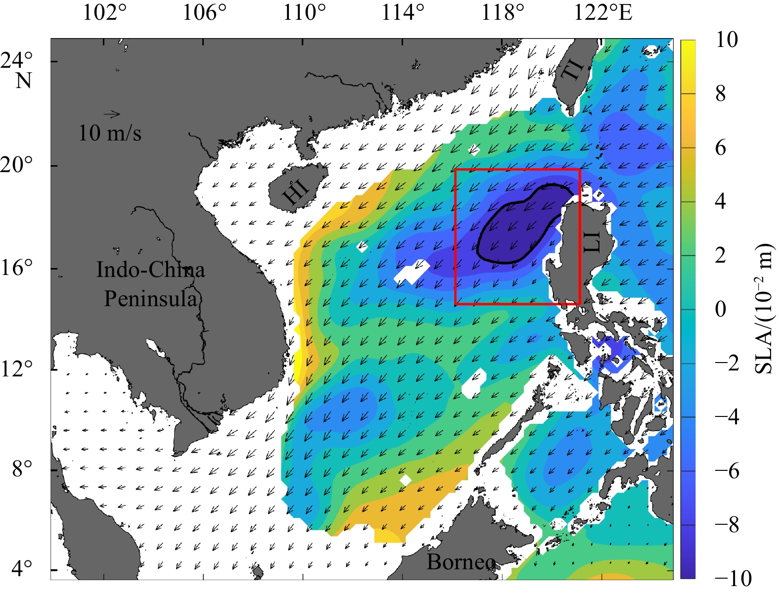
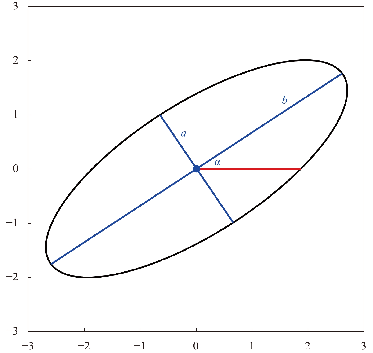
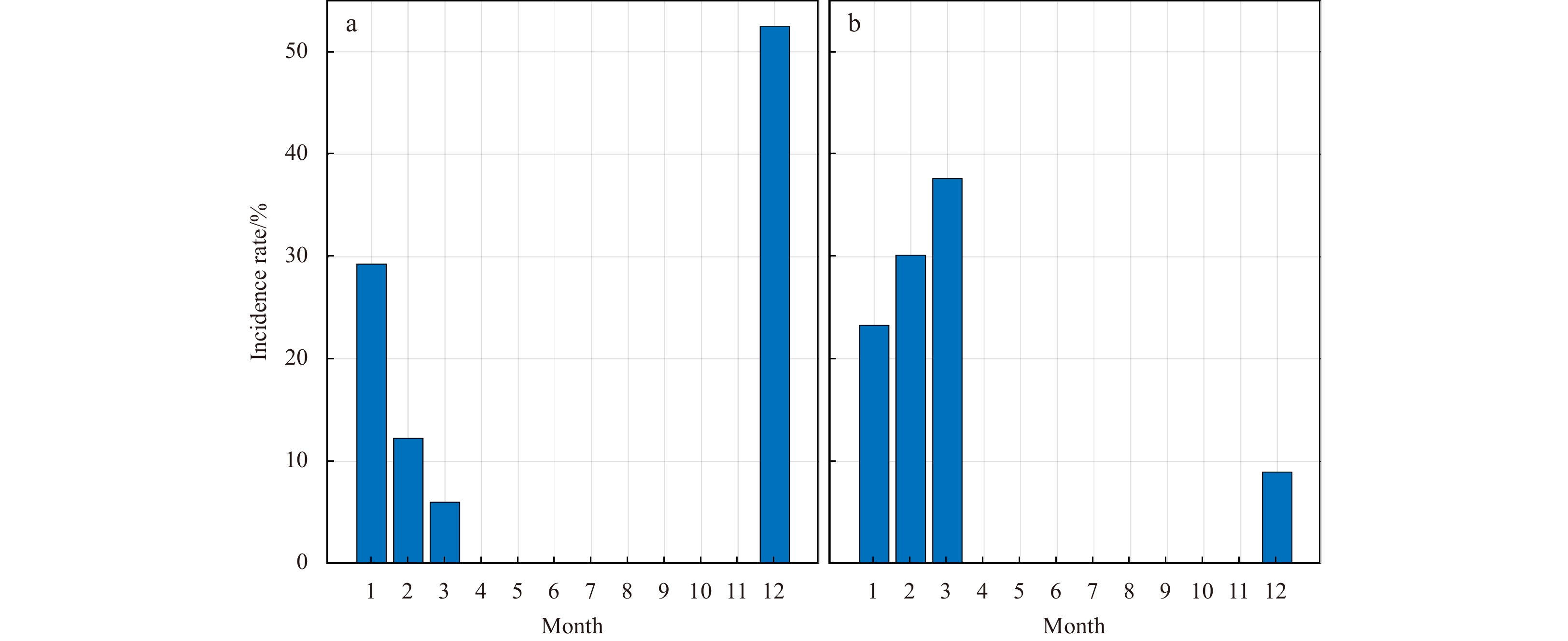
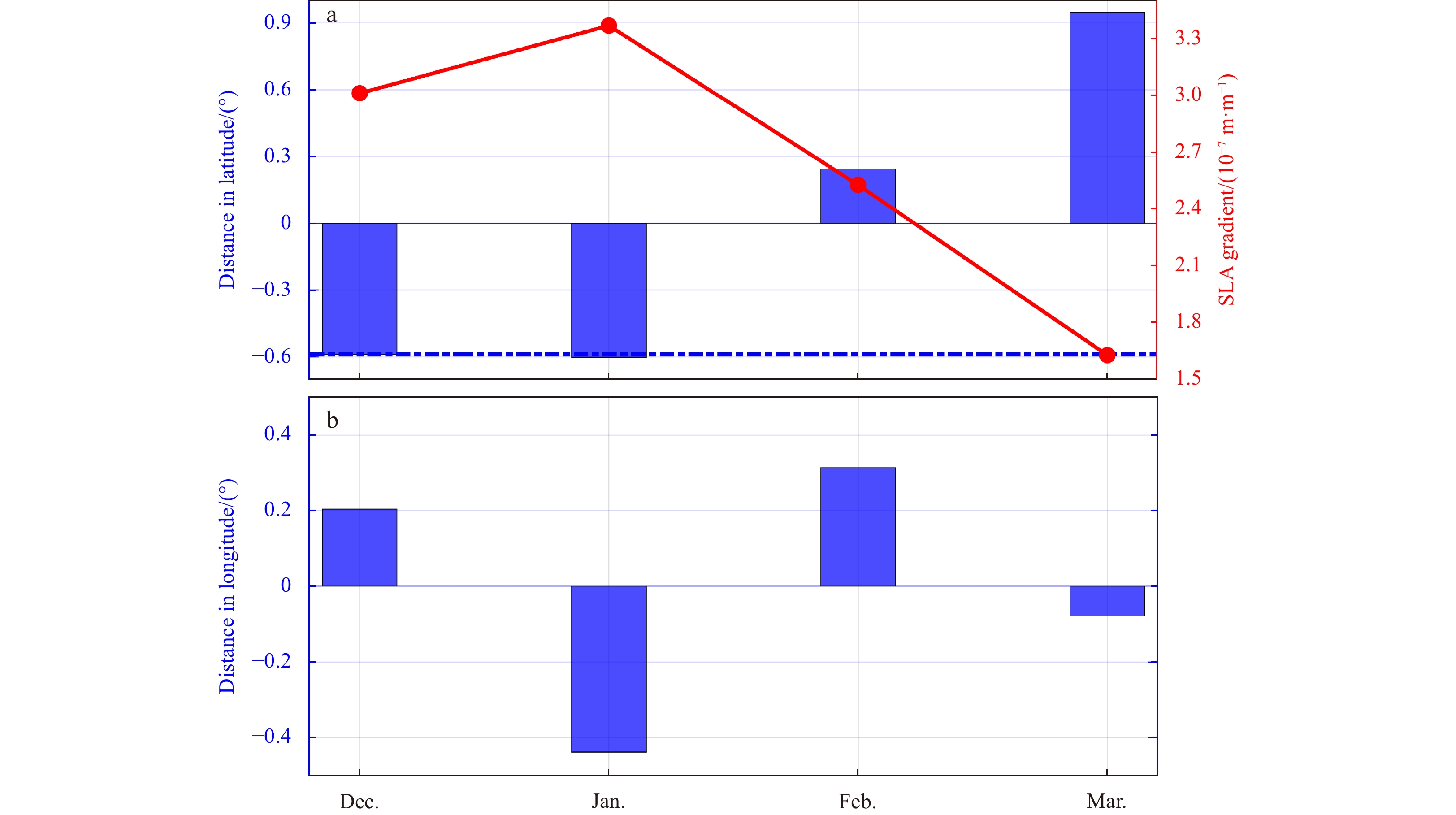
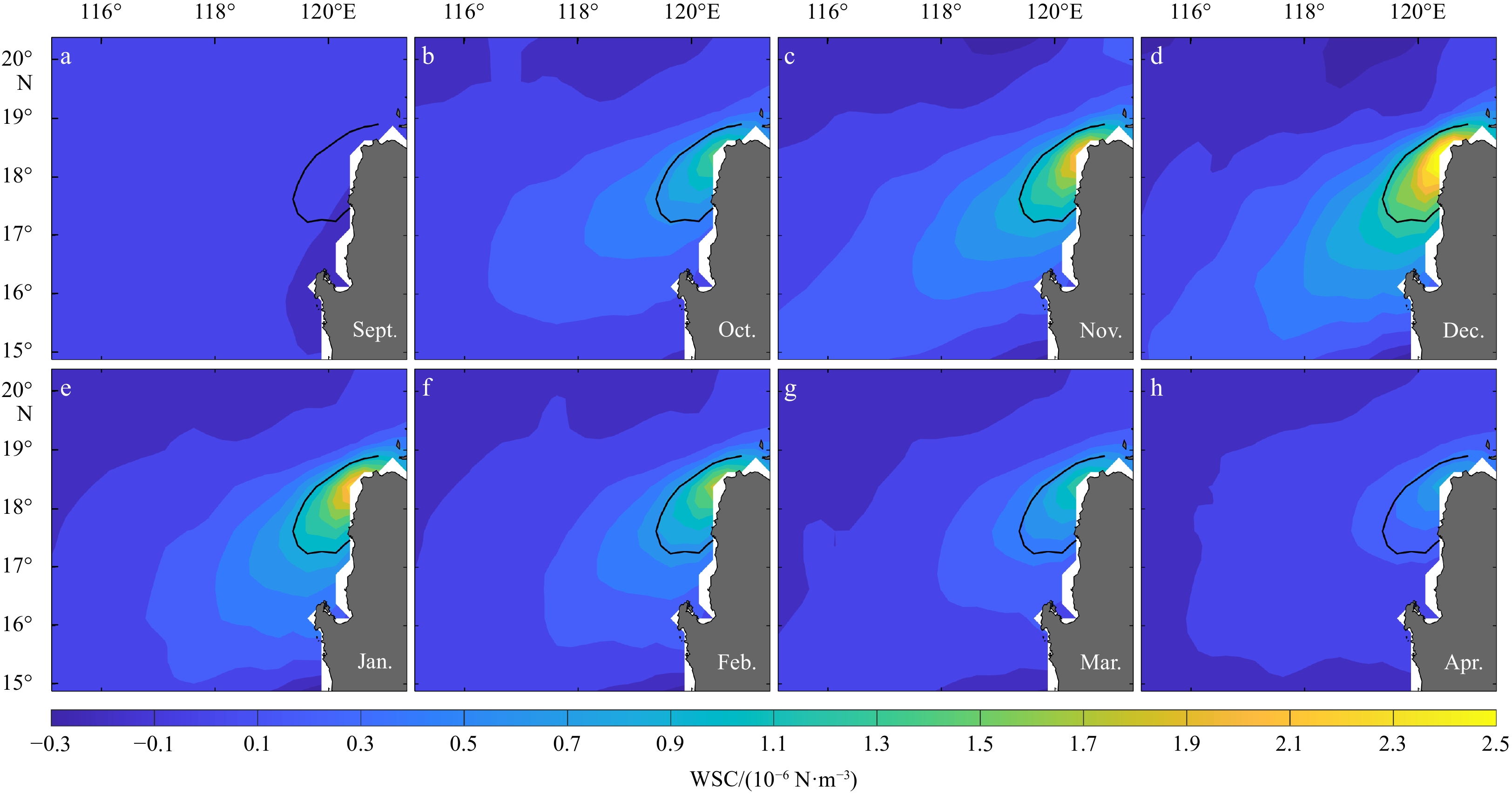
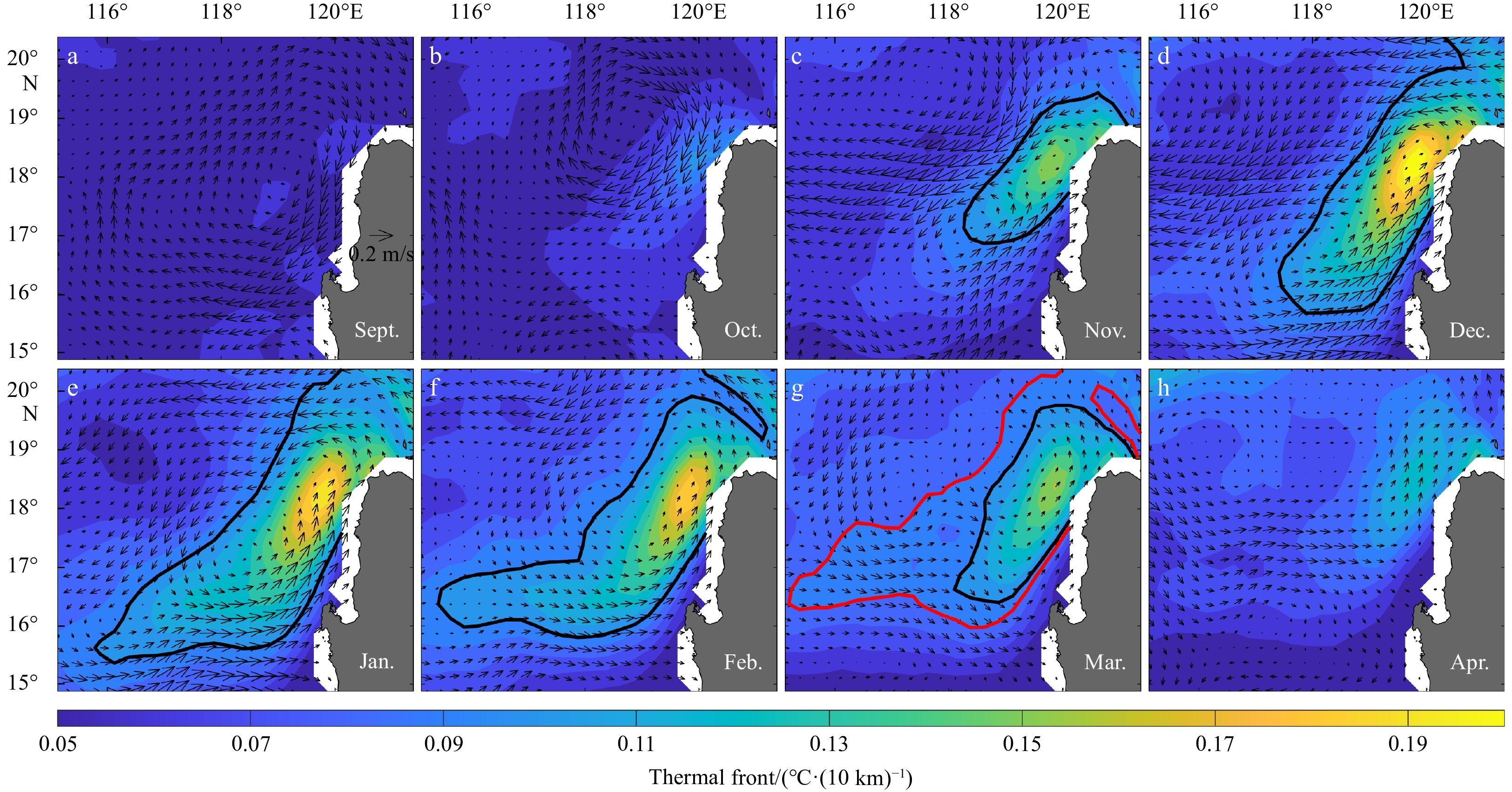
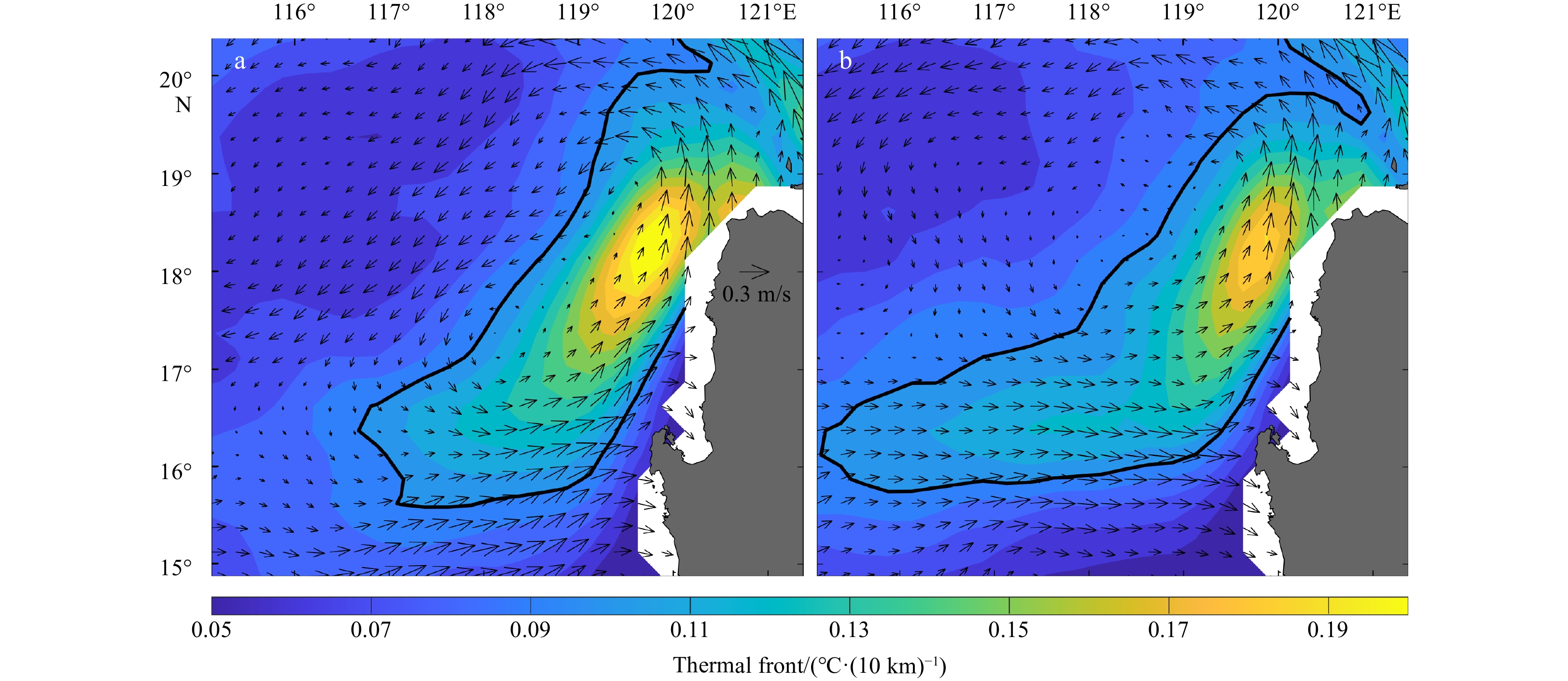
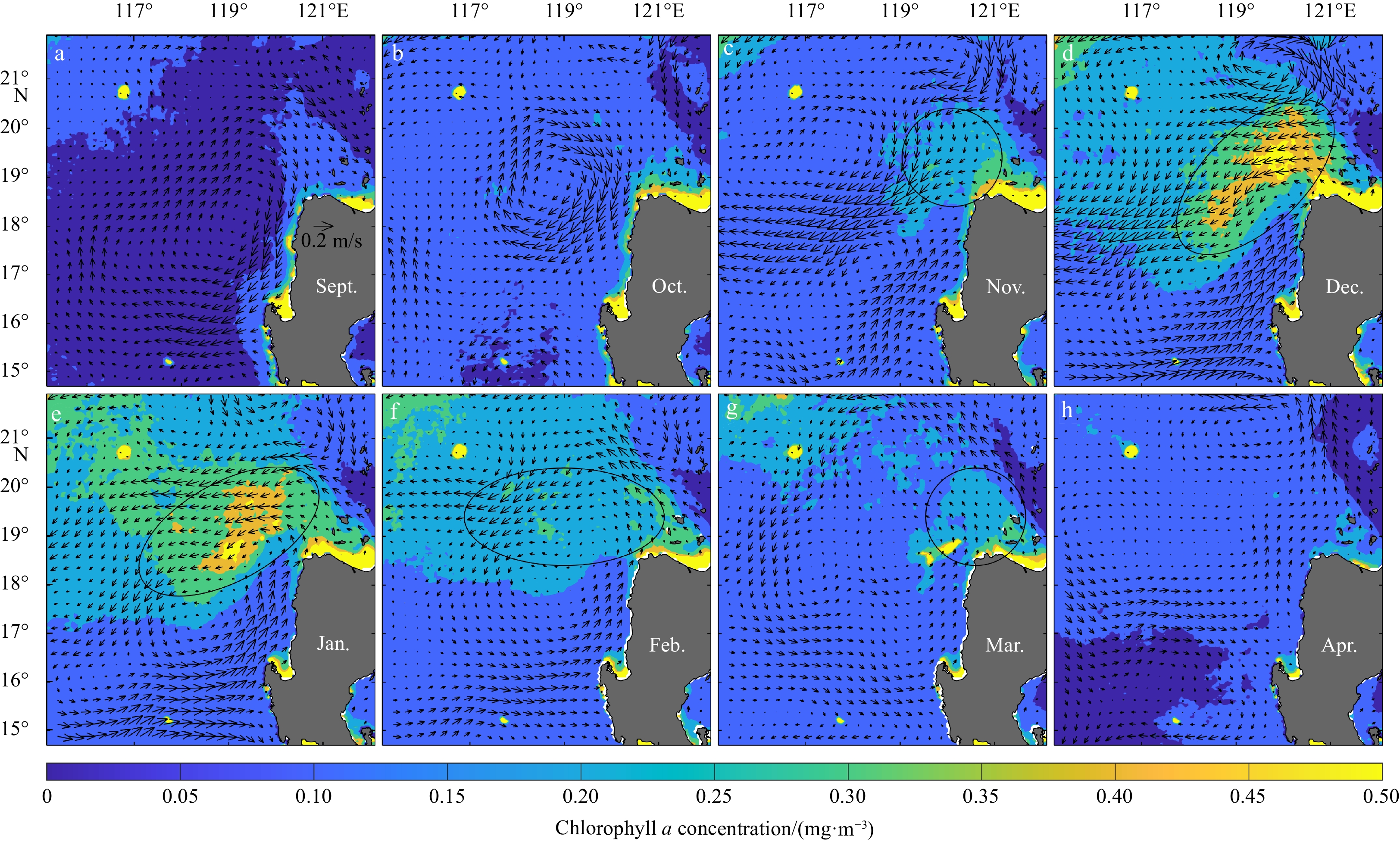
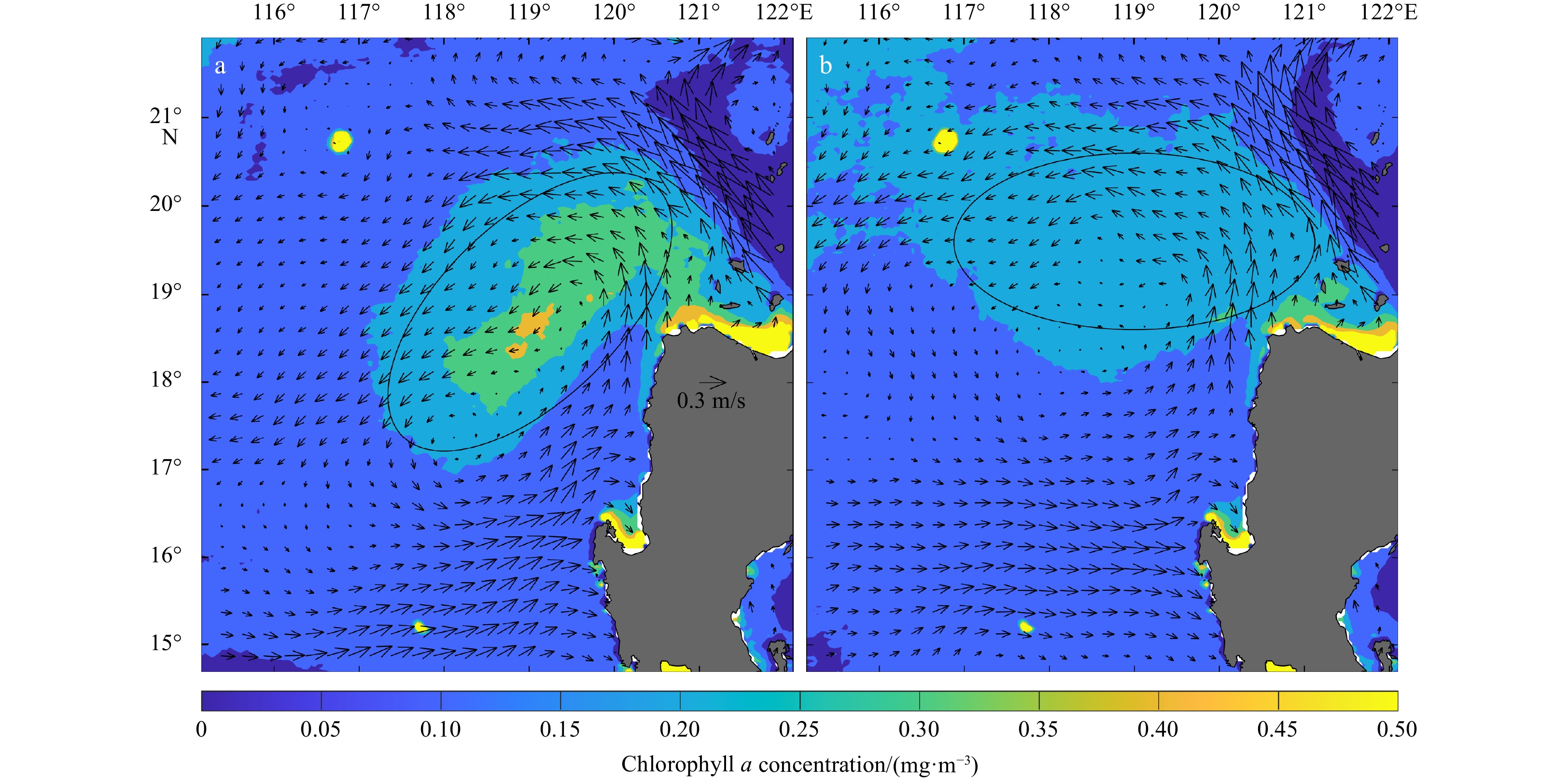
Using observational data from multiple satellites, we studied seasonal variations of the shape and location of the Luzon cold eddy (LCE) northwest of Luzon Island. The shape and location of the LCE have obvious seasonal variations. The LCE occurs, develops, and disappears from December to April of the next year. During this period, the shape of the LCE changed from a flat ellipse to a circular ellipse, and the change in shape can be reflected by the increase of the ellipticity of the LCE from 0.16 to 0.82. The latitude of center location of the LCE changes from 17.4°N to 19°N, and the change in latitude can reach 1.6°. Further study showed that seasonal variation of the northeast monsoon intensity leads to the change in the shape and location of the LCE. The seasonal variation of the LCE shape can significantly alter the spatial distribution of the thermal front and chlorophyll a northwest of the Luzon Island by geostrophic advection.
Using observational data from multiple satellites, we studied seasonal variations of the shape and location of the Luzon cold eddy (LCE) northwest of Luzon Island. The shape and location of the LCE have obvious seasonal variations. The LCE occurs, develops, and disappears from December to April of the next year. During this period, the shape of the LCE changed from a flat ellipse to a circular ellipse, and the change in shape can be reflected by the increase of the ellipticity of the LCE from 0.16 to 0.82. The latitude of center location of the LCE changes from 17.4°N to 19°N, and the change in latitude can reach 1.6°. Further study showed that seasonal variation of the northeast monsoon intensity leads to the change in the shape and location of the LCE. The seasonal variation of the LCE shape can significantly alter the spatial distribution of the thermal front and chlorophyll a northwest of the Luzon Island by geostrophic advection.


2023, 42(5): 25-34.
doi: 10.1007/s13131-022-2074-5
Abstract:
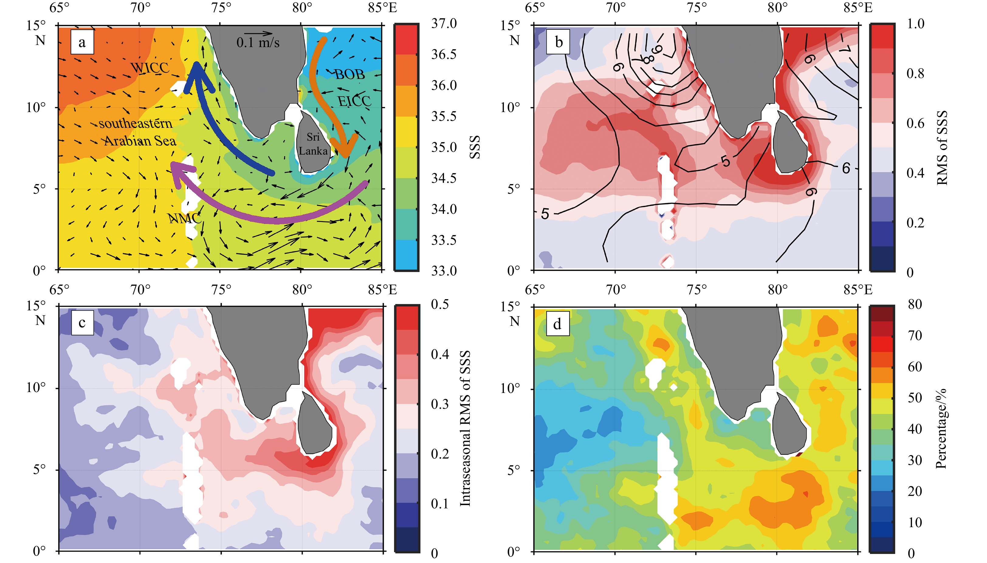
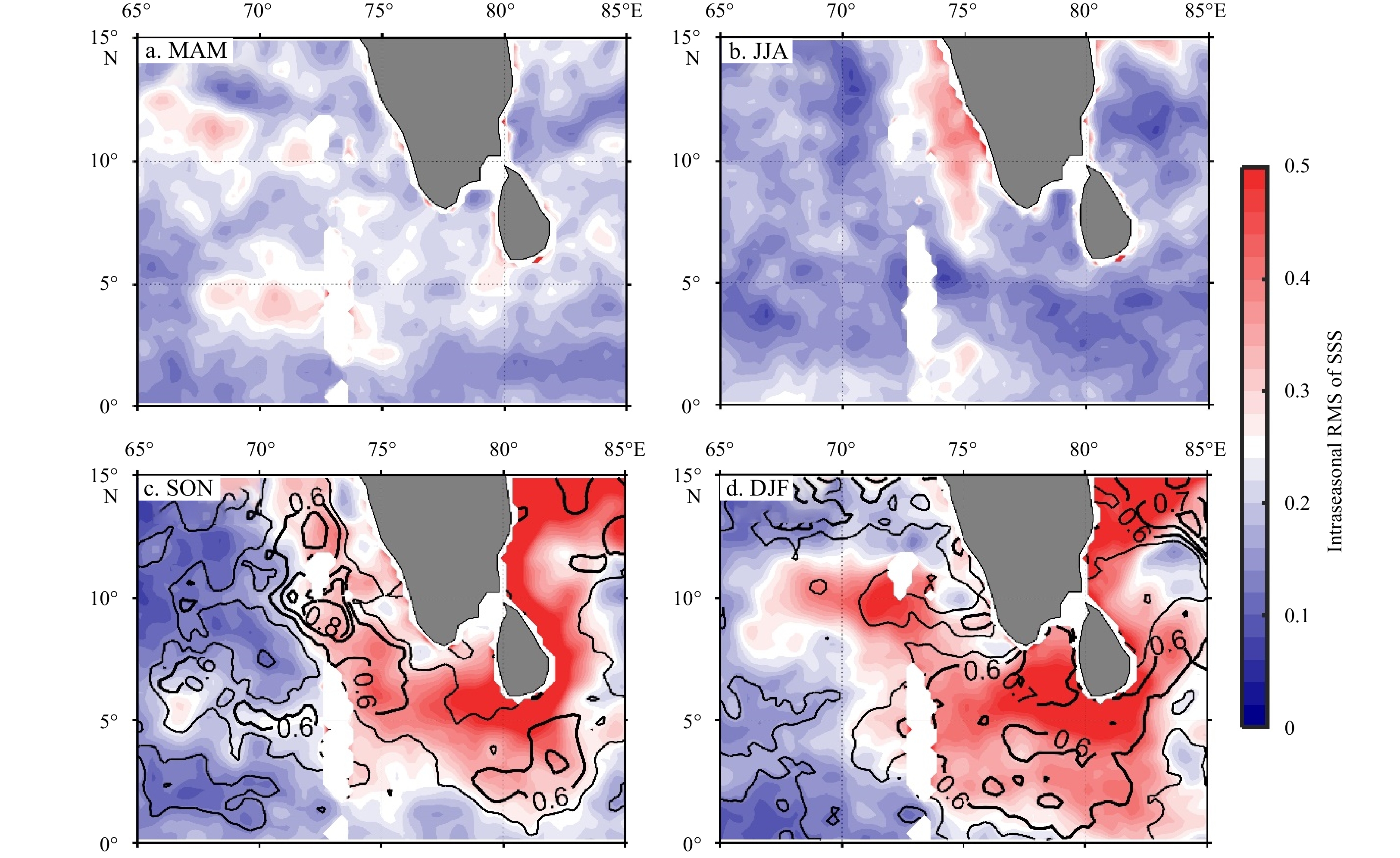
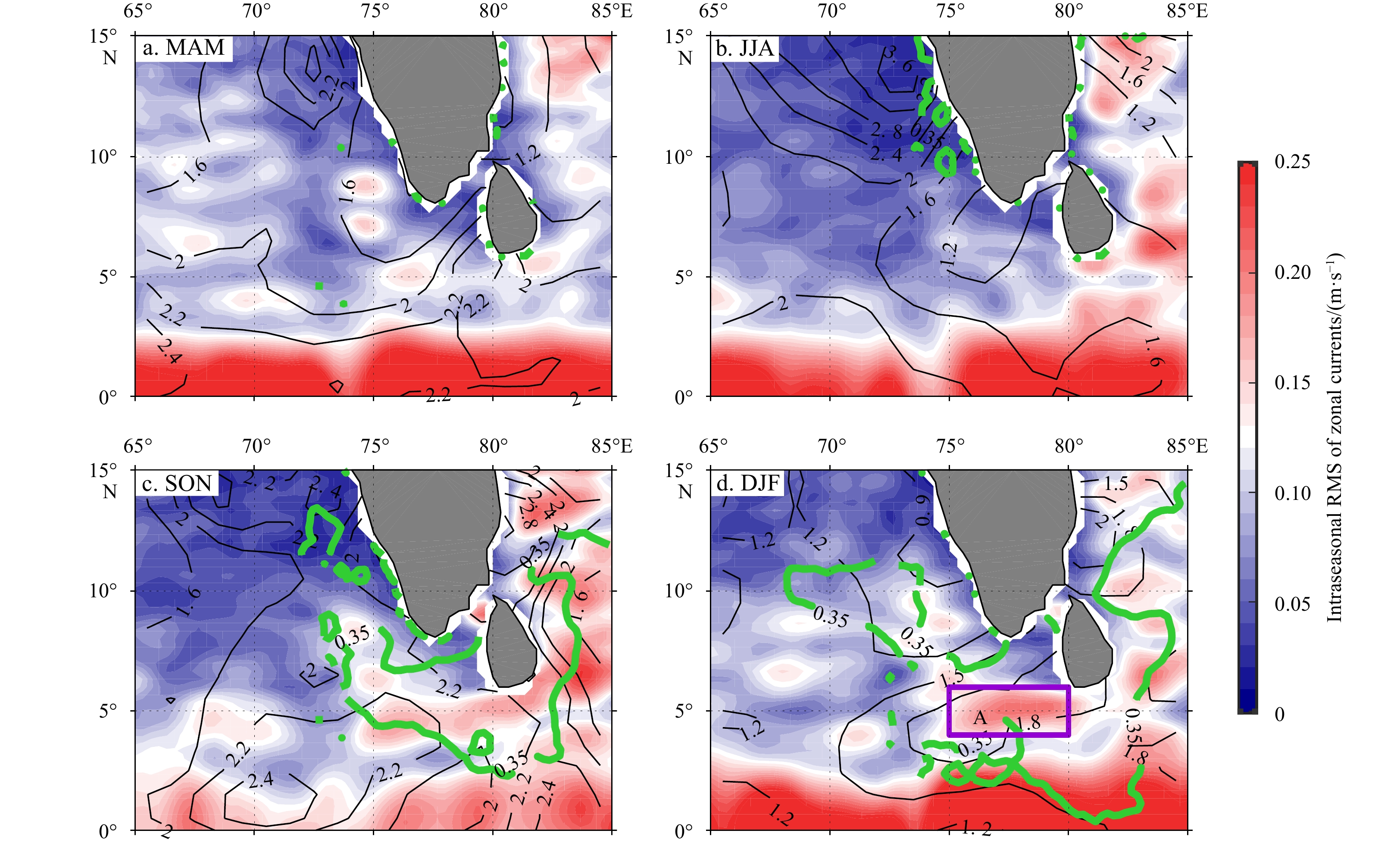
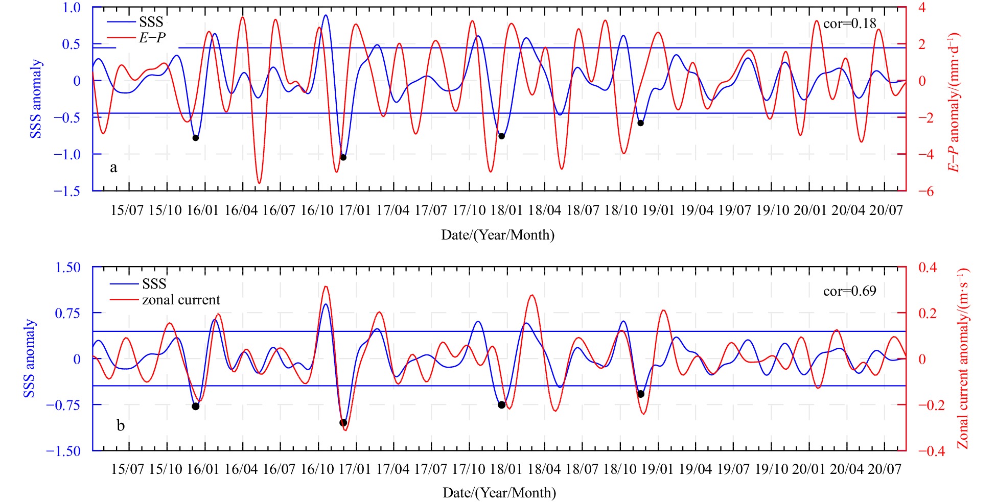
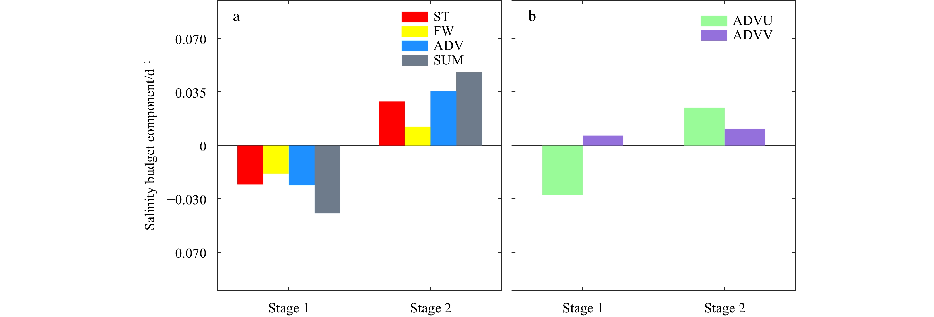
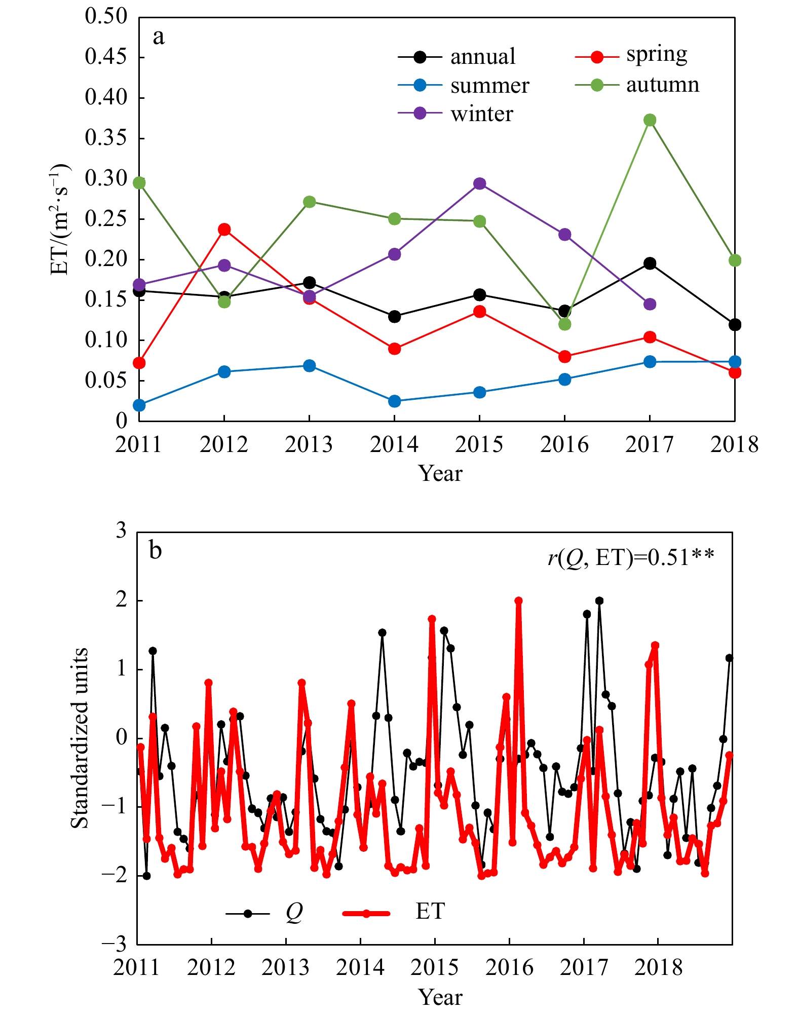
Based on Soil Moisture Active Passive sea surface salinity (SSS) data from April 2015 to August 2020, combined with Objectively Analyzed Air-Sea Heat Flux and other observational data and Hybrid Coordinate Ocean Model (HYCOM) data, this work explores the characteristics and mechanisms of the intraseasonal variability of SSS in the southeastern Arabian Sea (SEAS). The results show that the intraseasonal variability of SSS in the SEAS is very significant, especially the strongest intraseasonal signal in SSS, which is located along the northeast monsoon current (NMC) path south of the Indian Peninsula. There are remarkable seasonal differences in intraseasonal SSS variability, which is very weak in spring and summer and much stronger in autumn and winter. This strong intraseasonal variability in autumn and winter is closely related to the Madden-Julian Oscillation (MJO) event during this period. The northeast wind anomaly in the Bay of Bengal (BOB) associated with the active MJO phase strengthens the East India Coastal Current and NMC and consequently induces more BOB low-salinity water to enter the SEAS, causing strong SSS fluctuations. In addition, MJO-related precipitation further amplifies the intraseasonal variability of SSS in SEAS. Based on budget analysis of the mixed layer salinity using HYCOM data, it is shown that horizontal salinity advection (especially zonal advection) dominates the intraseasonal variability of mixed layer salinity and that surface freshwater flux has a secondary role.
Based on Soil Moisture Active Passive sea surface salinity (SSS) data from April 2015 to August 2020, combined with Objectively Analyzed Air-Sea Heat Flux and other observational data and Hybrid Coordinate Ocean Model (HYCOM) data, this work explores the characteristics and mechanisms of the intraseasonal variability of SSS in the southeastern Arabian Sea (SEAS). The results show that the intraseasonal variability of SSS in the SEAS is very significant, especially the strongest intraseasonal signal in SSS, which is located along the northeast monsoon current (NMC) path south of the Indian Peninsula. There are remarkable seasonal differences in intraseasonal SSS variability, which is very weak in spring and summer and much stronger in autumn and winter. This strong intraseasonal variability in autumn and winter is closely related to the Madden-Julian Oscillation (MJO) event during this period. The northeast wind anomaly in the Bay of Bengal (BOB) associated with the active MJO phase strengthens the East India Coastal Current and NMC and consequently induces more BOB low-salinity water to enter the SEAS, causing strong SSS fluctuations. In addition, MJO-related precipitation further amplifies the intraseasonal variability of SSS in SEAS. Based on budget analysis of the mixed layer salinity using HYCOM data, it is shown that horizontal salinity advection (especially zonal advection) dominates the intraseasonal variability of mixed layer salinity and that surface freshwater flux has a secondary role.


Sea spray induced air-sea heat and salt fluxes based on the wave-steepness-dependent sea spray model
2023, 42(5): 35-41.
doi: 10.1007/s13131-022-2073-6
Abstract:
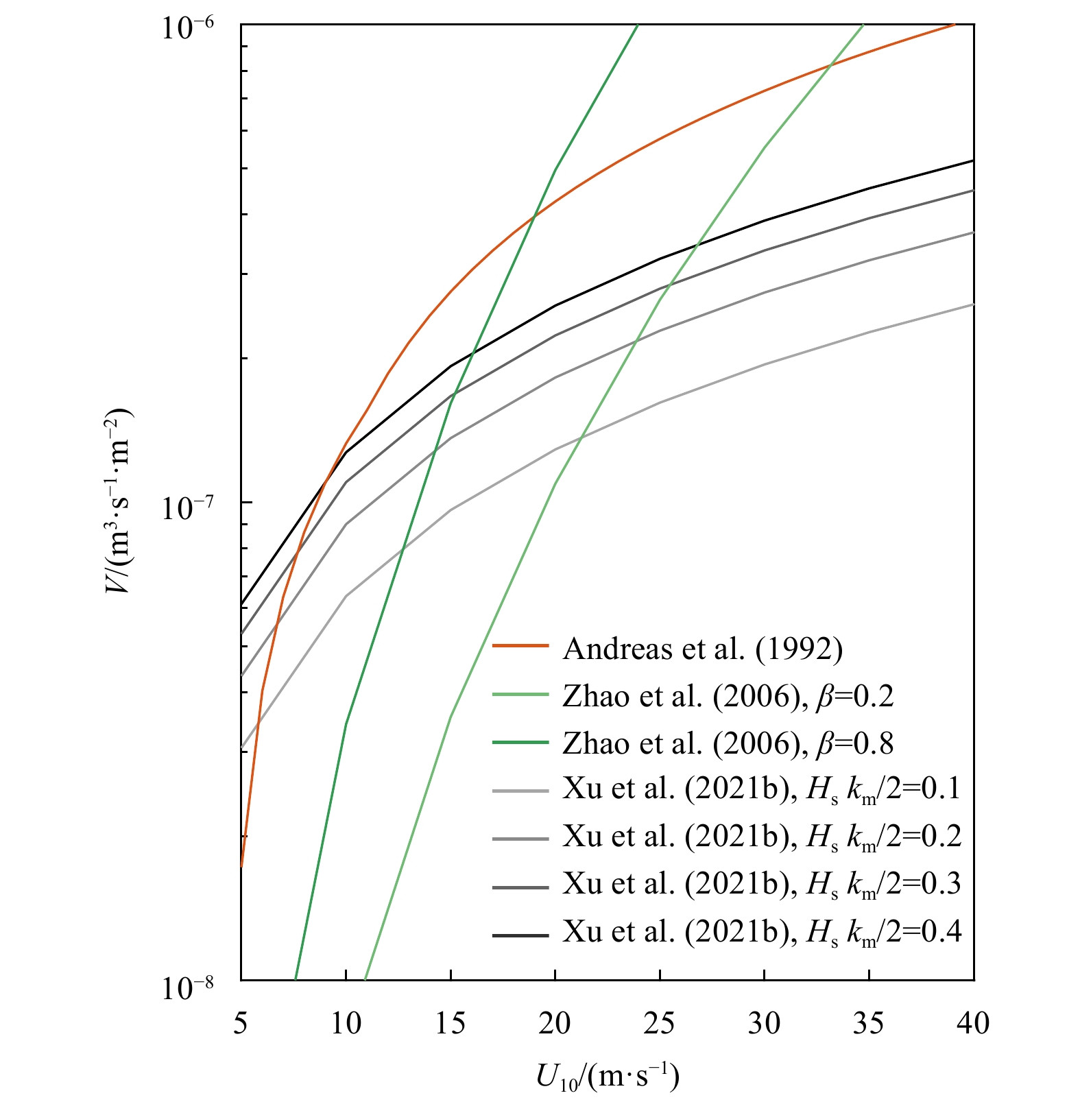
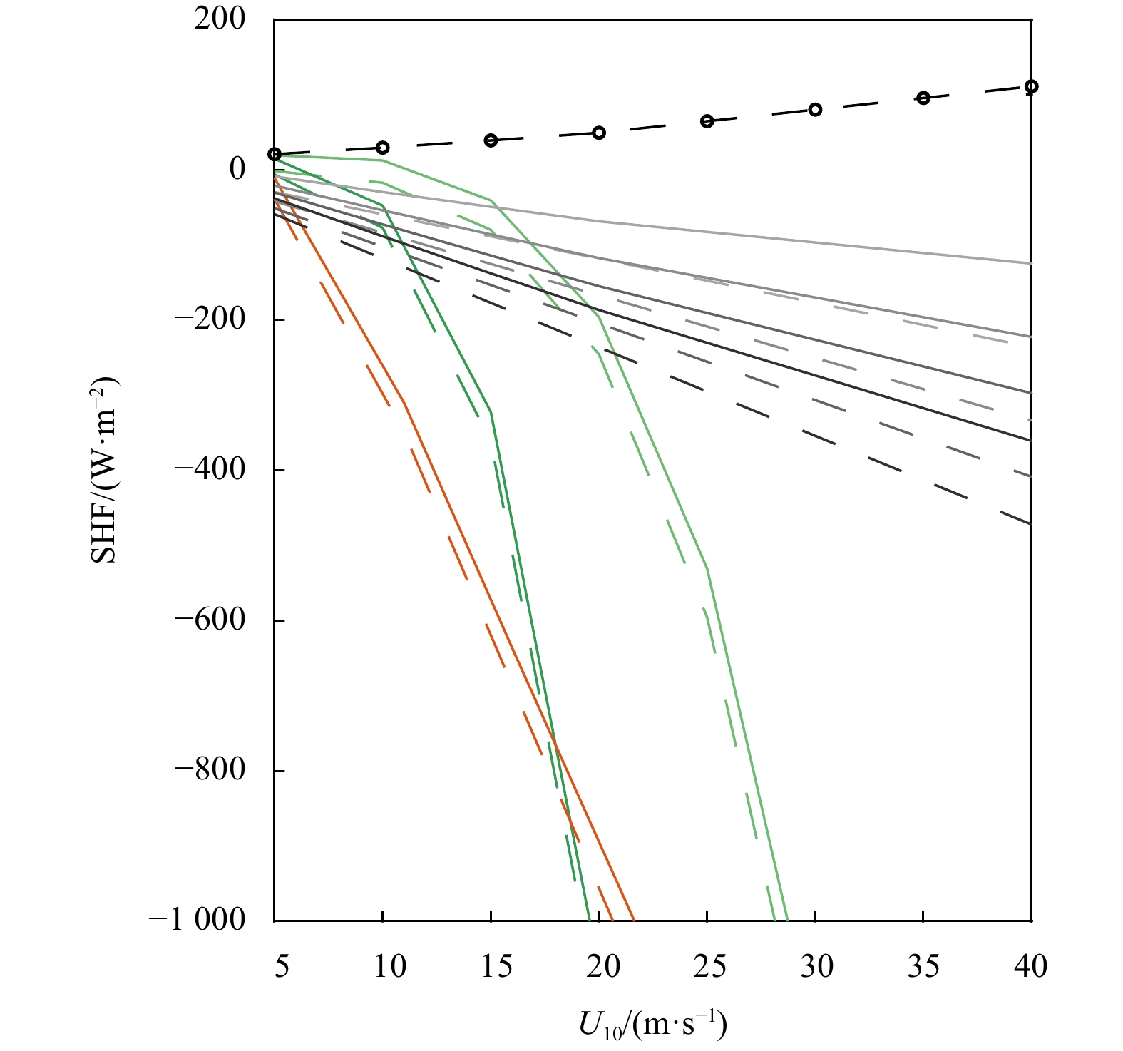
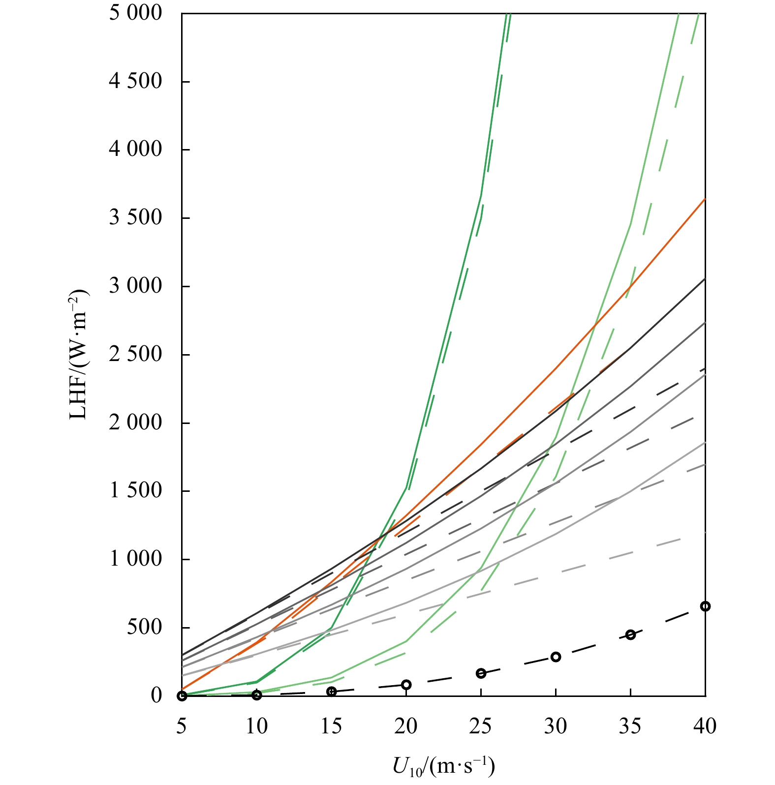
Sea spray, which comprises amounts of small ocean droplets, plays a significant role in the air-sea coupling, atmospheric and oceanic dynamics, and climate. However, it remains arduous to arrive at estimates for the efficiency and accuracy of the sea spray induced air-sea heat and salt fluxes. This is because the microphysical process of sea spray evolution in the air is of extreme complexity. In this study, we iteratively calculated the sea spray induced air-sea heat and salt fluxes at various weather condition. To do so, we implemented one novel wave-steepness-dependent sea spray model into a bulk air-sea fluxes algorithm and utilized other sea spray models as comparisons. Based on the improved wave-dependent bulk turbulent algorithm, we observed that despite the negative contribution of sea spray to the sensible heat fluxes, the sea spray positively contributes to the air-sea latent heat fluxes, leading to an overall increase in the total air-sea heat fluxes. The additional heat fluxes caused by sea spray may be the missing critical process that can clarify the discrepancies observed between measured and modelled Tropical Cyclone’s development and intensification. In addition to heat fluxes, we observed that sea spray has significant impacts on the air-sea salt fluxes. As the sea salt particles are one of the main sources of the atmosphere aerosol, our results imply that sea spray could impact global and regional climate. Thus, given the significance of sea spray on the air-sea boundary layer, sea spray effects need to be considered in studies of air-sea interaction, dynamics of atmosphere and ocean.
Sea spray, which comprises amounts of small ocean droplets, plays a significant role in the air-sea coupling, atmospheric and oceanic dynamics, and climate. However, it remains arduous to arrive at estimates for the efficiency and accuracy of the sea spray induced air-sea heat and salt fluxes. This is because the microphysical process of sea spray evolution in the air is of extreme complexity. In this study, we iteratively calculated the sea spray induced air-sea heat and salt fluxes at various weather condition. To do so, we implemented one novel wave-steepness-dependent sea spray model into a bulk air-sea fluxes algorithm and utilized other sea spray models as comparisons. Based on the improved wave-dependent bulk turbulent algorithm, we observed that despite the negative contribution of sea spray to the sensible heat fluxes, the sea spray positively contributes to the air-sea latent heat fluxes, leading to an overall increase in the total air-sea heat fluxes. The additional heat fluxes caused by sea spray may be the missing critical process that can clarify the discrepancies observed between measured and modelled Tropical Cyclone’s development and intensification. In addition to heat fluxes, we observed that sea spray has significant impacts on the air-sea salt fluxes. As the sea salt particles are one of the main sources of the atmosphere aerosol, our results imply that sea spray could impact global and regional climate. Thus, given the significance of sea spray on the air-sea boundary layer, sea spray effects need to be considered in studies of air-sea interaction, dynamics of atmosphere and ocean.


2023, 42(5): 42-56.
doi: 10.1007/s13131-022-2024-2
Abstract:
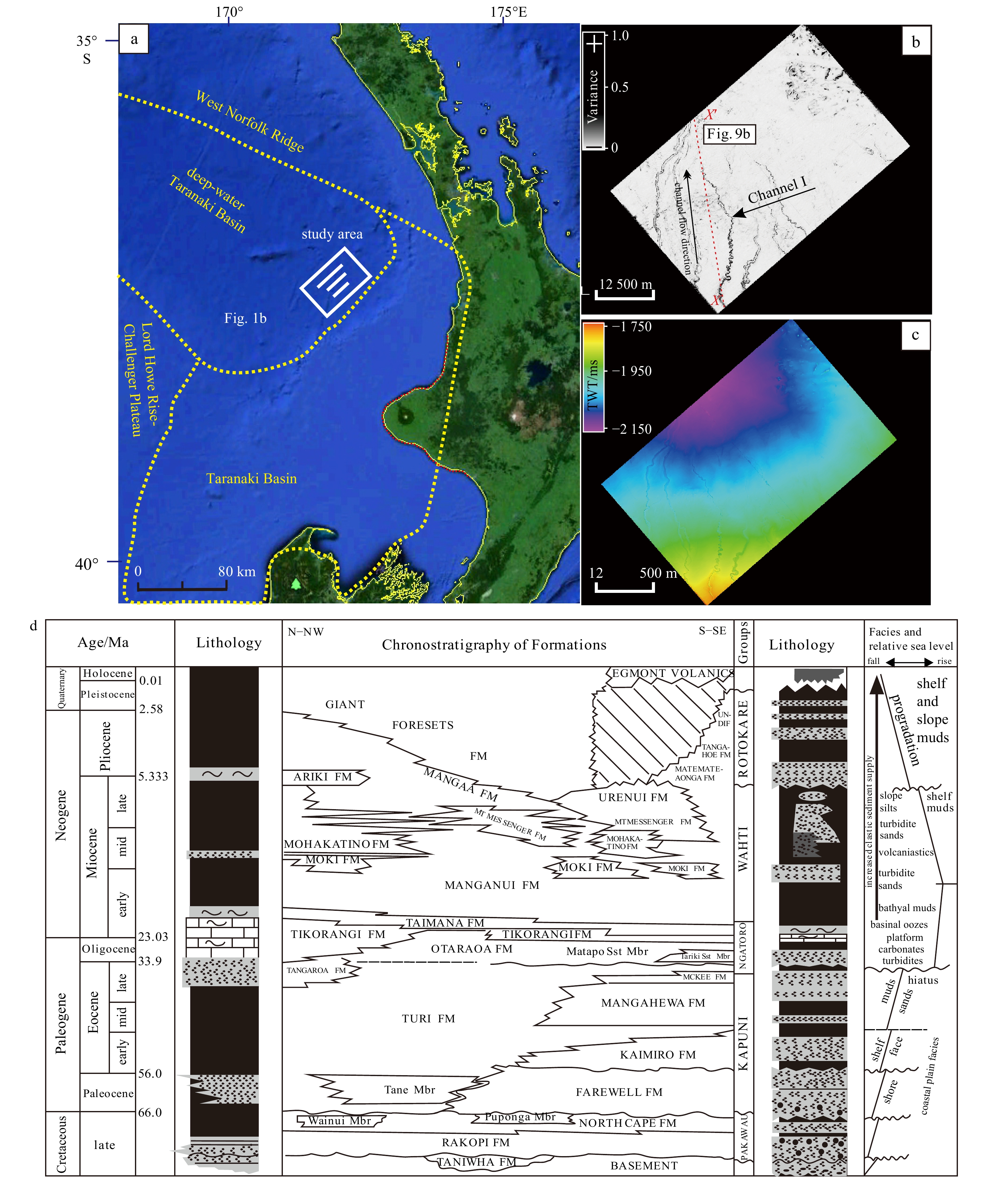
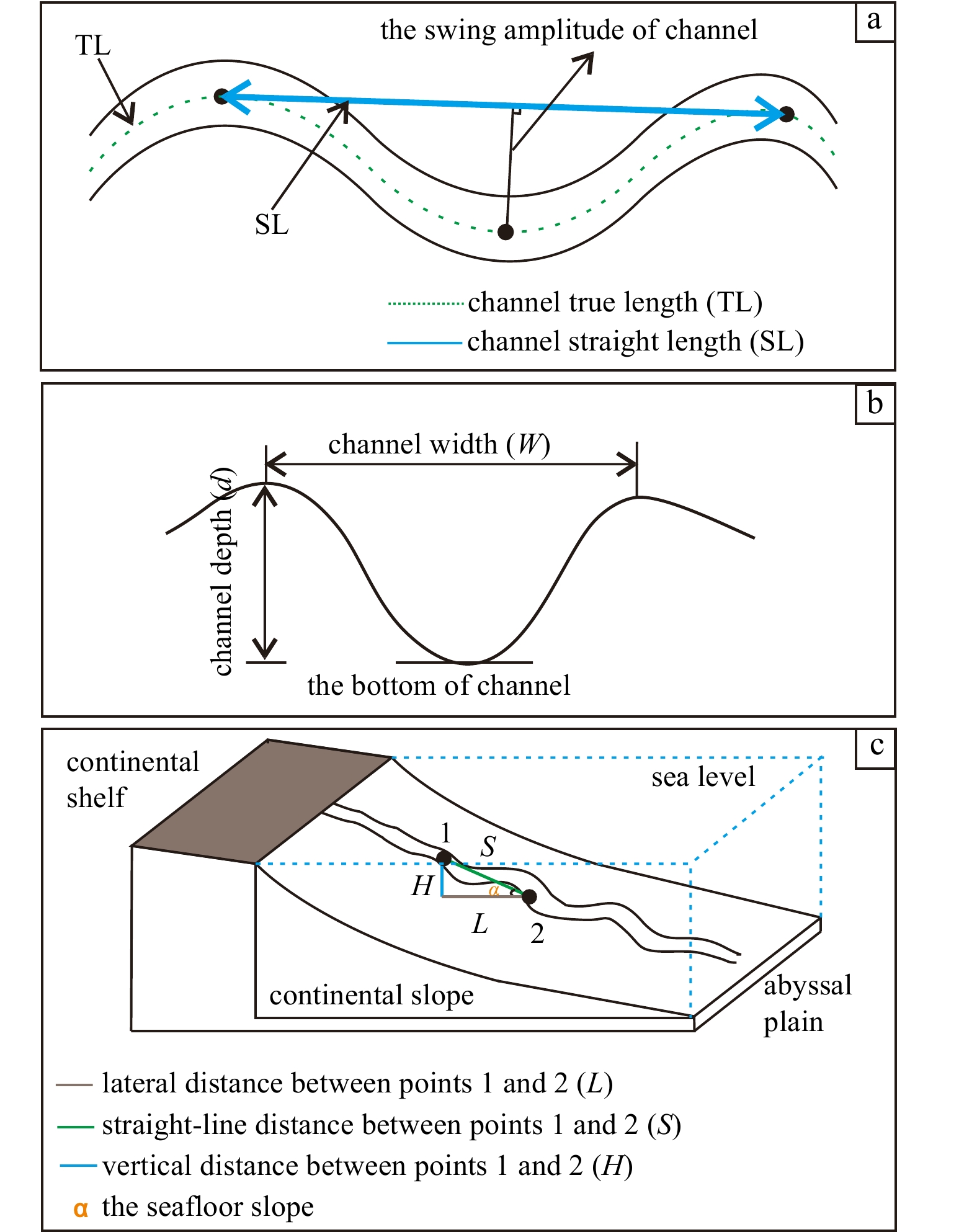
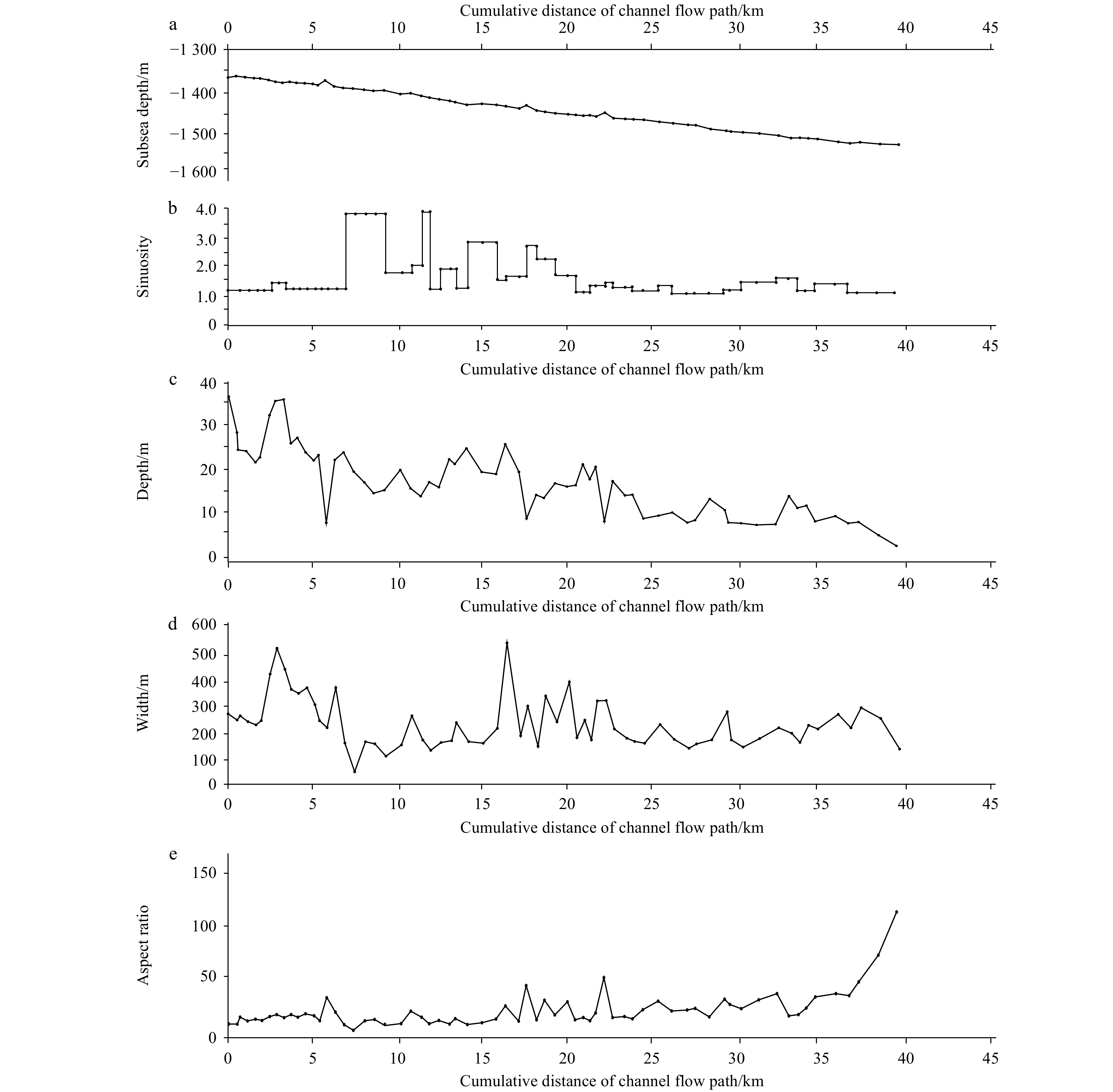
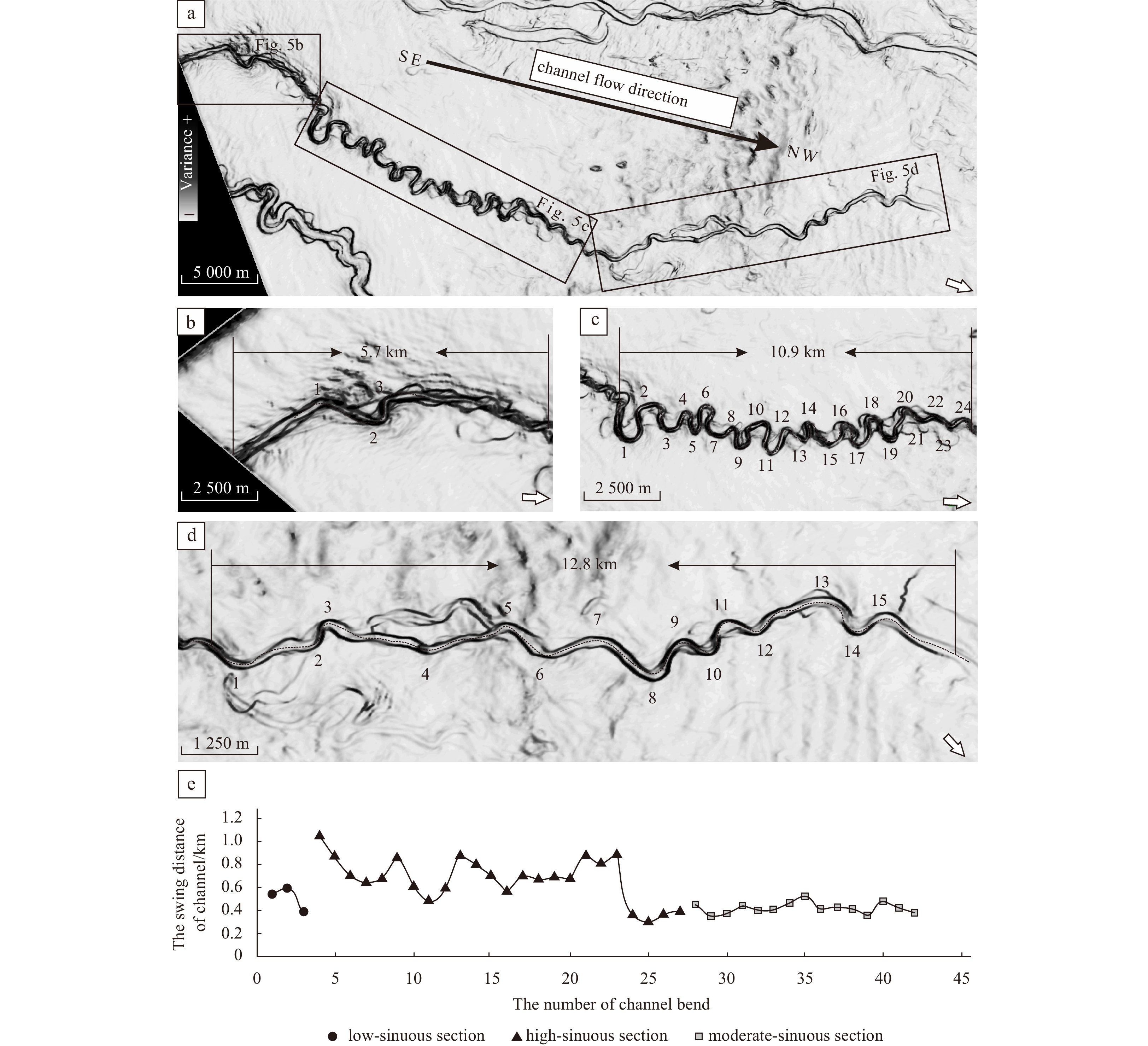
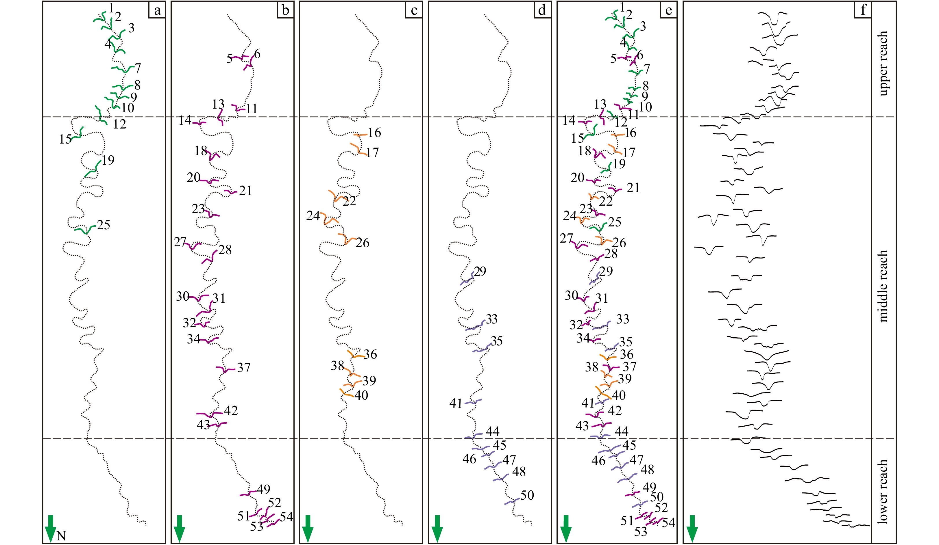
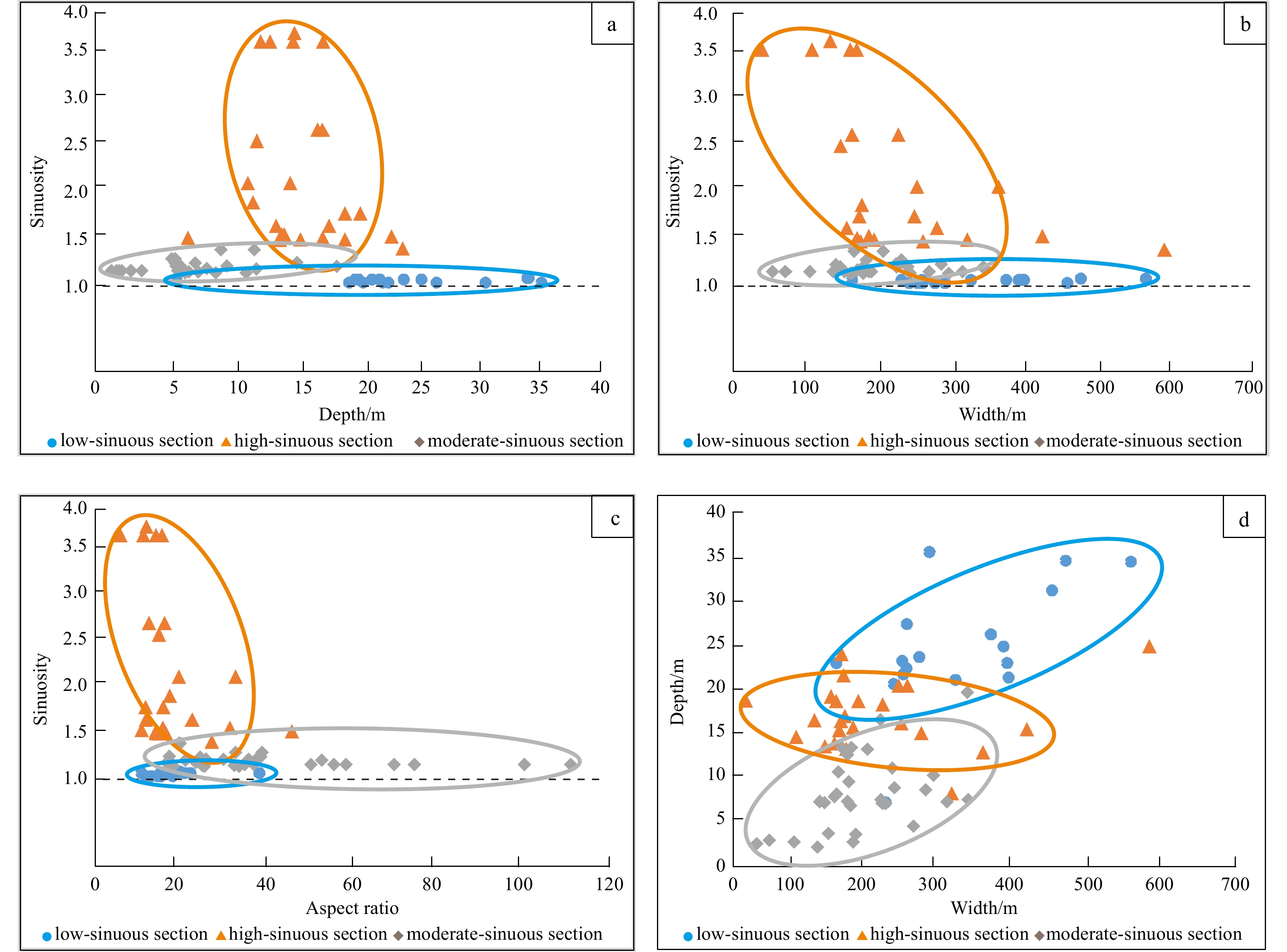
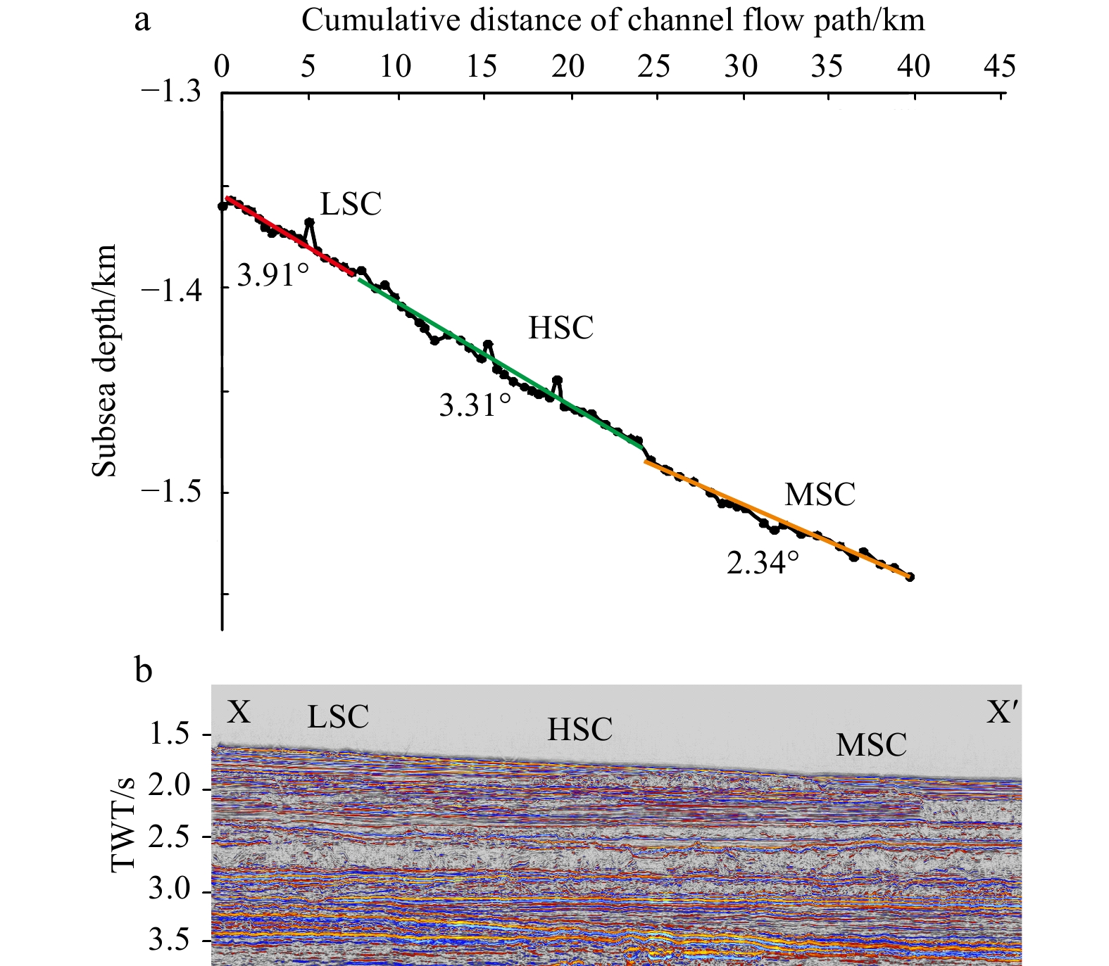
The morphological changes of deep-water channels have an important influence on the distributions of channel sand reservoirs, so it is important to explore the morphological change process of deep-water channel for the exploration and development of deep-water oil and gas. Based on a typical sinuous Quaternary channel (Channel I) in the Taranaki Basin, New Zealand, a variety of seismic interpretation techniques were applied to quantitatively characterize the morphological characteristics of the Channel I, and the relationships between the quantitative parameters and the morphological changes of the Channel I, as well as the controlling factors affecting those morphological changes, were discussed. The results are as follows: (1) in the quantitative analysis, six parameters were selected: the channel depth, width, sinuosity, and aspect ratio (width/depth), the channel swing amplitude (λ) and the channel bend frequency (ω); (2) according to the quantitative morphological parameters of the channel (mainly including three parameters such as channel sinuosity, ω and λ), the Channel I was divided into three types: the low-sinuous channel (LSC), the high-sinuous channel (HSC), the moderate-sinuous channel (MSC). U-shaped channel cross-sections developed in the LSC, V-shaped channel cross-sections developed in the HSC, including inclined-V and symmetric-V cross-sections, and dish-shaped channel cross-sections developed in the MSC; (3) the morphological characteristics of the LSC and MSC were related to their widths and depths, while the morphology of the HSC was greatly affected by the channel width, a change in depth did not affect the HSC morphology; (4) the morphological changes of the Channel I were controlled mainly by the slope gradient, the restricted capacity of the channel and the differential in fluid properties.
The morphological changes of deep-water channels have an important influence on the distributions of channel sand reservoirs, so it is important to explore the morphological change process of deep-water channel for the exploration and development of deep-water oil and gas. Based on a typical sinuous Quaternary channel (Channel I) in the Taranaki Basin, New Zealand, a variety of seismic interpretation techniques were applied to quantitatively characterize the morphological characteristics of the Channel I, and the relationships between the quantitative parameters and the morphological changes of the Channel I, as well as the controlling factors affecting those morphological changes, were discussed. The results are as follows: (1) in the quantitative analysis, six parameters were selected: the channel depth, width, sinuosity, and aspect ratio (width/depth), the channel swing amplitude (λ) and the channel bend frequency (ω); (2) according to the quantitative morphological parameters of the channel (mainly including three parameters such as channel sinuosity, ω and λ), the Channel I was divided into three types: the low-sinuous channel (LSC), the high-sinuous channel (HSC), the moderate-sinuous channel (MSC). U-shaped channel cross-sections developed in the LSC, V-shaped channel cross-sections developed in the HSC, including inclined-V and symmetric-V cross-sections, and dish-shaped channel cross-sections developed in the MSC; (3) the morphological characteristics of the LSC and MSC were related to their widths and depths, while the morphology of the HSC was greatly affected by the channel width, a change in depth did not affect the HSC morphology; (4) the morphological changes of the Channel I were controlled mainly by the slope gradient, the restricted capacity of the channel and the differential in fluid properties.


2023, 42(5): 57-78.
doi: 10.1007/s13131-022-2071-8
Abstract:
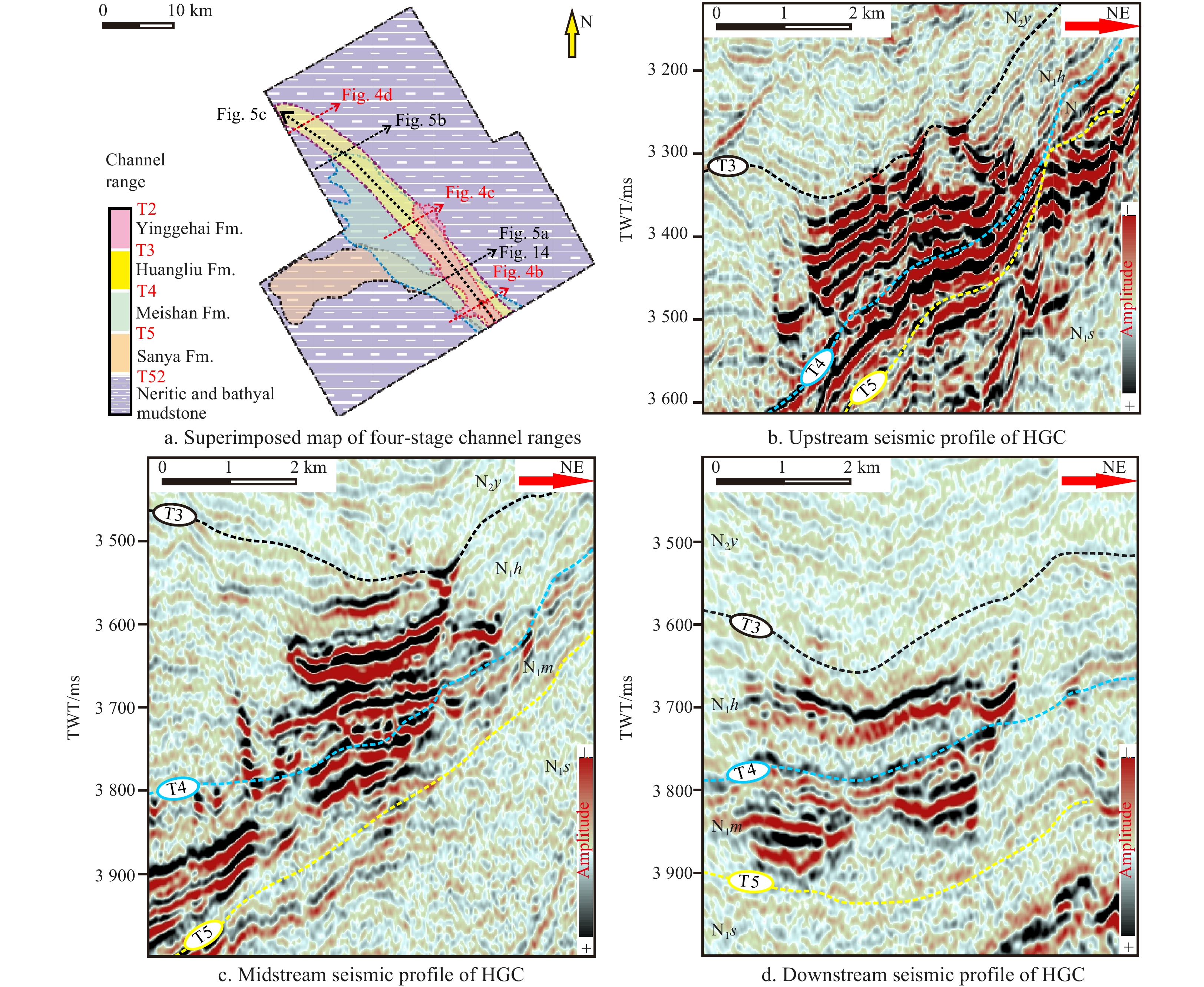
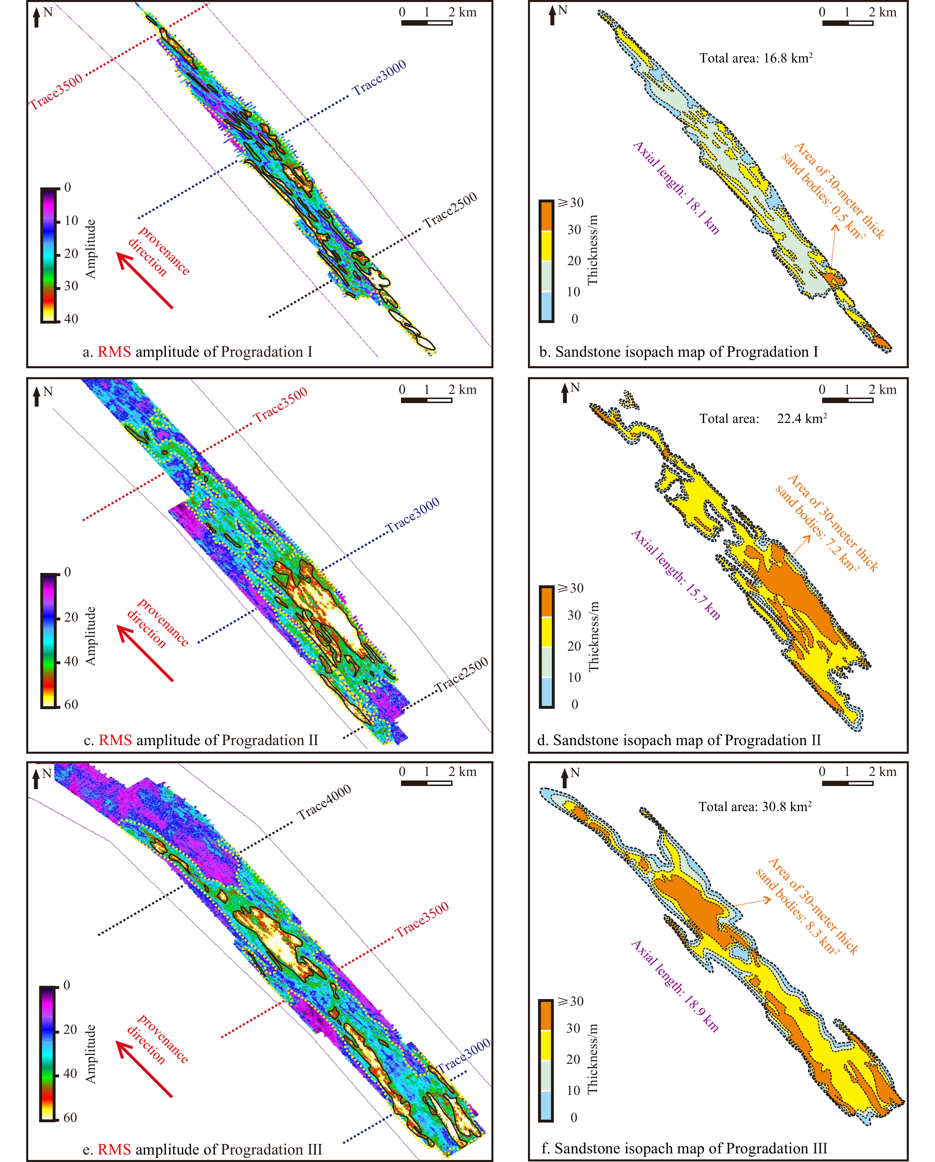
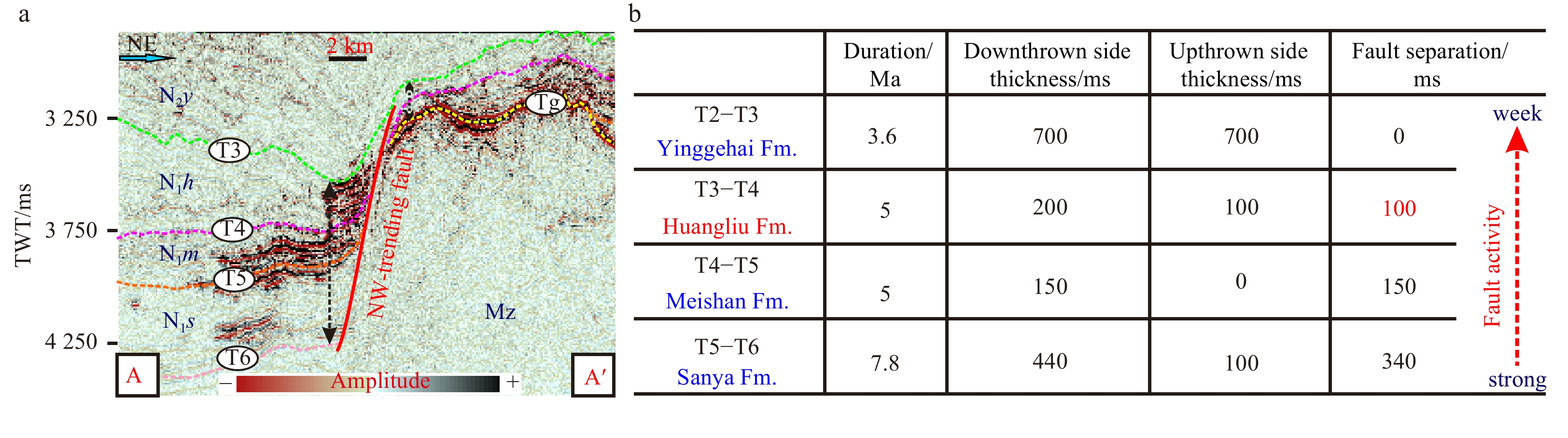
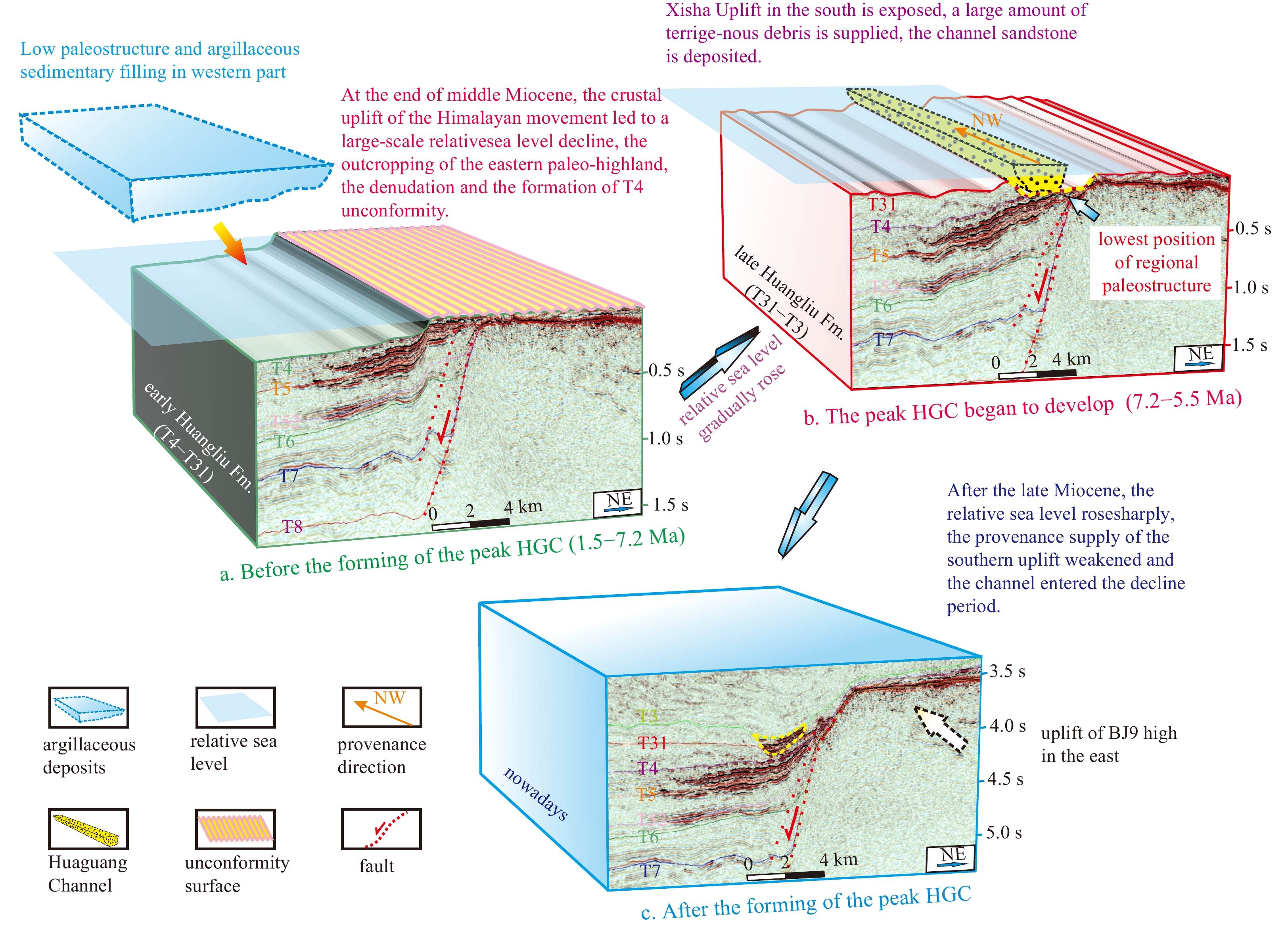
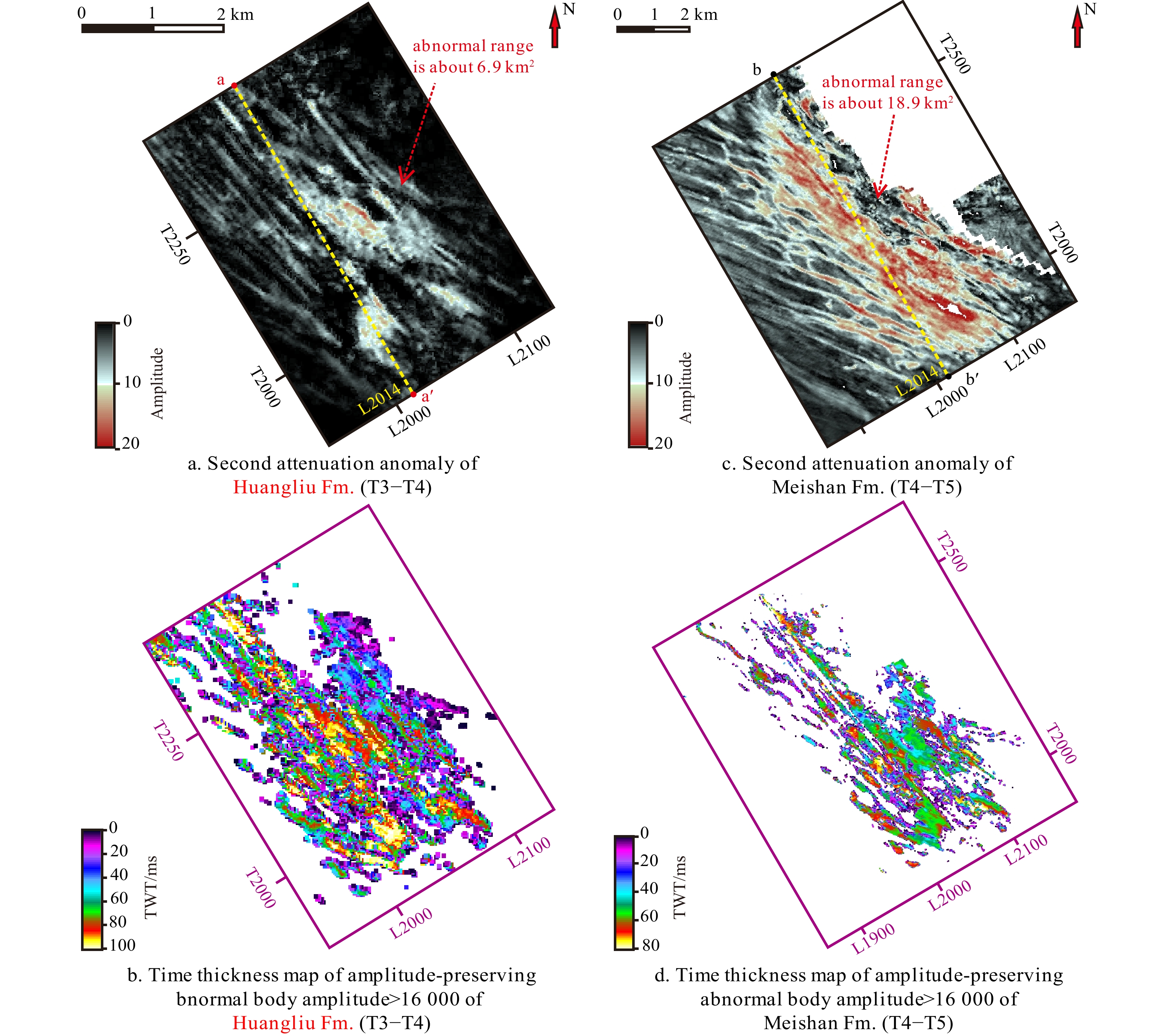
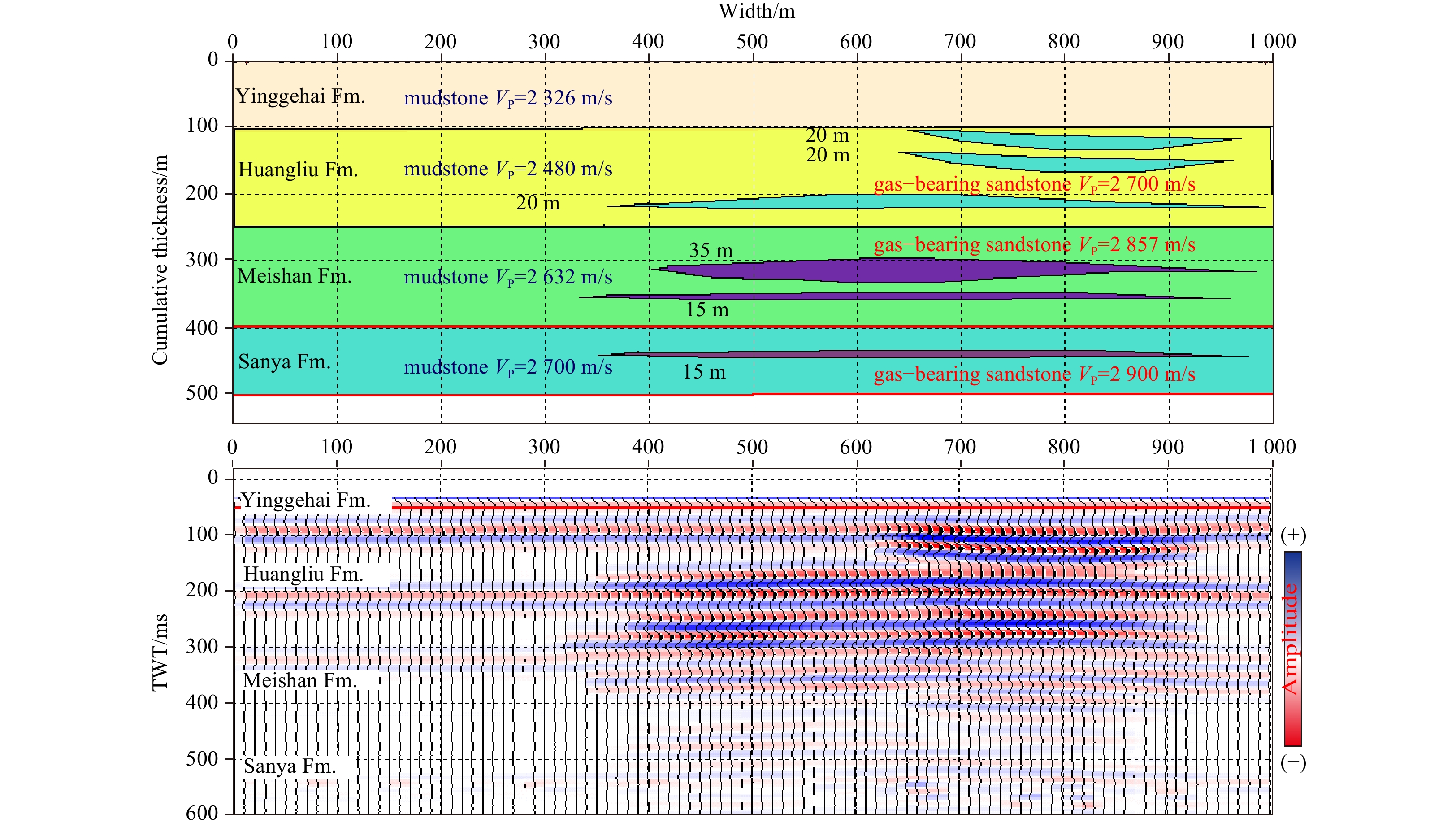
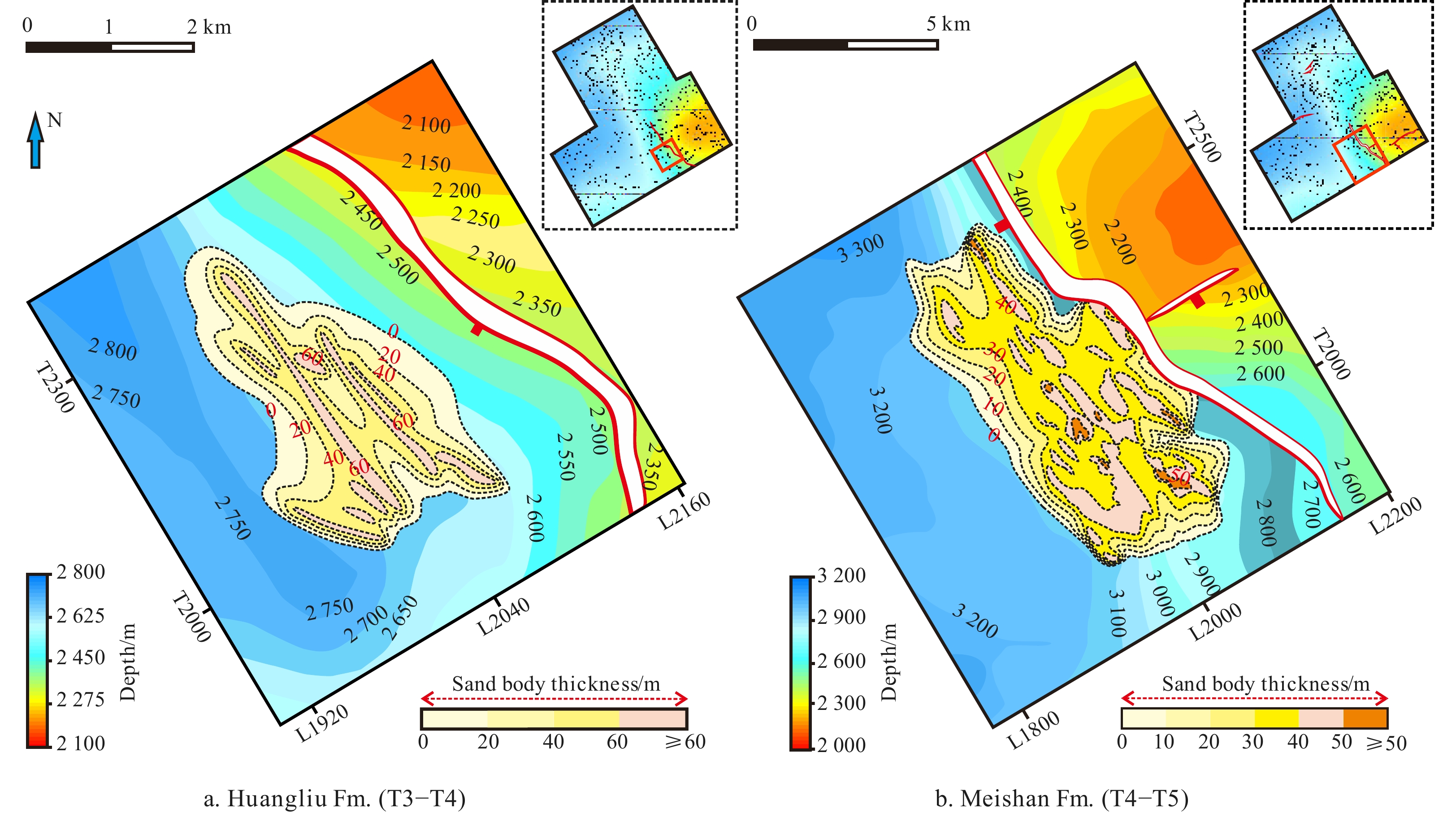
A rarely reported middle−late Miocene−Pliocene channel (incised valley fill), the Huaguang Channel (HGC), has been found in the deep-water area of the southwestern Qiongdongnan Basin (QDNB). This channel is almost perpendicular to the orientation of another well-known, large, and nearly coeval submarine channel in this area. Based on the interpretation of high-resolution 3D seismic data, this study describes and analyzes the stratigraphy, tectonics, sedimentation, morphology, structure and evolution of HGC by means of well-seismic synthetic calibration, one- and two-dimensional forward modeling, attribute interpretation, tectonic interpretation, and gas detection. The HGC is located on the downthrown side of an earlier activated normal fault and grew northwestward along the fault strike. The channel is part of a slope that extends from the western Huaguang Sag to the eastern Beijiao Uplift. The HGC underwent four developmental stages: the (1) incubation (late Sanya Formation, 20.4–15.5 Ma), (2) embryonic (Meishan Formation, 15.5–10.5 Ma), (3) peak (Huangliu Formation, 10.5–5.5 Ma) and (4) decline (Yinggehai Formation, 5.5–1.9 Ma) stages. The channel sandstones have a provenance from the southern Yongle Uplift and filled the channel via multistage vertical amalgamation and lateral migration. The channel extended 42.5 km in an approximately straight pattern in the peak stage. At 10.5 Ma, sea level fell relative to its lowest level, and three oblique progradation turbidite sand bodies filled the channel from south to north. A channel sandstone isopach map demonstrated a narrow distribution in the early stages and a fan-shaped distribution in the late stage. The formation and evolution of the HGC were controlled mainly by background tectonics, fault strike, relative sea level change, and mass supply from the Yongle Uplift. The HGC sandstone reservoir is near the Huaguangjiao Sag, where hydrocarbons were generated. Channel-bounding faults and underlying faults link the source rock with the reservoir. A regionally extensive mudstone caprock overlies the channel sandstone. Two traps likely containing gas were recognized in a structural high upstream of the channel from seismic attenuation anomalies. The HGC will likely become an important oil and gas accumulation setting in the QDNB deep-water area.
A rarely reported middle−late Miocene−Pliocene channel (incised valley fill), the Huaguang Channel (HGC), has been found in the deep-water area of the southwestern Qiongdongnan Basin (QDNB). This channel is almost perpendicular to the orientation of another well-known, large, and nearly coeval submarine channel in this area. Based on the interpretation of high-resolution 3D seismic data, this study describes and analyzes the stratigraphy, tectonics, sedimentation, morphology, structure and evolution of HGC by means of well-seismic synthetic calibration, one- and two-dimensional forward modeling, attribute interpretation, tectonic interpretation, and gas detection. The HGC is located on the downthrown side of an earlier activated normal fault and grew northwestward along the fault strike. The channel is part of a slope that extends from the western Huaguang Sag to the eastern Beijiao Uplift. The HGC underwent four developmental stages: the (1) incubation (late Sanya Formation, 20.4–15.5 Ma), (2) embryonic (Meishan Formation, 15.5–10.5 Ma), (3) peak (Huangliu Formation, 10.5–5.5 Ma) and (4) decline (Yinggehai Formation, 5.5–1.9 Ma) stages. The channel sandstones have a provenance from the southern Yongle Uplift and filled the channel via multistage vertical amalgamation and lateral migration. The channel extended 42.5 km in an approximately straight pattern in the peak stage. At 10.5 Ma, sea level fell relative to its lowest level, and three oblique progradation turbidite sand bodies filled the channel from south to north. A channel sandstone isopach map demonstrated a narrow distribution in the early stages and a fan-shaped distribution in the late stage. The formation and evolution of the HGC were controlled mainly by background tectonics, fault strike, relative sea level change, and mass supply from the Yongle Uplift. The HGC sandstone reservoir is near the Huaguangjiao Sag, where hydrocarbons were generated. Channel-bounding faults and underlying faults link the source rock with the reservoir. A regionally extensive mudstone caprock overlies the channel sandstone. Two traps likely containing gas were recognized in a structural high upstream of the channel from seismic attenuation anomalies. The HGC will likely become an important oil and gas accumulation setting in the QDNB deep-water area.


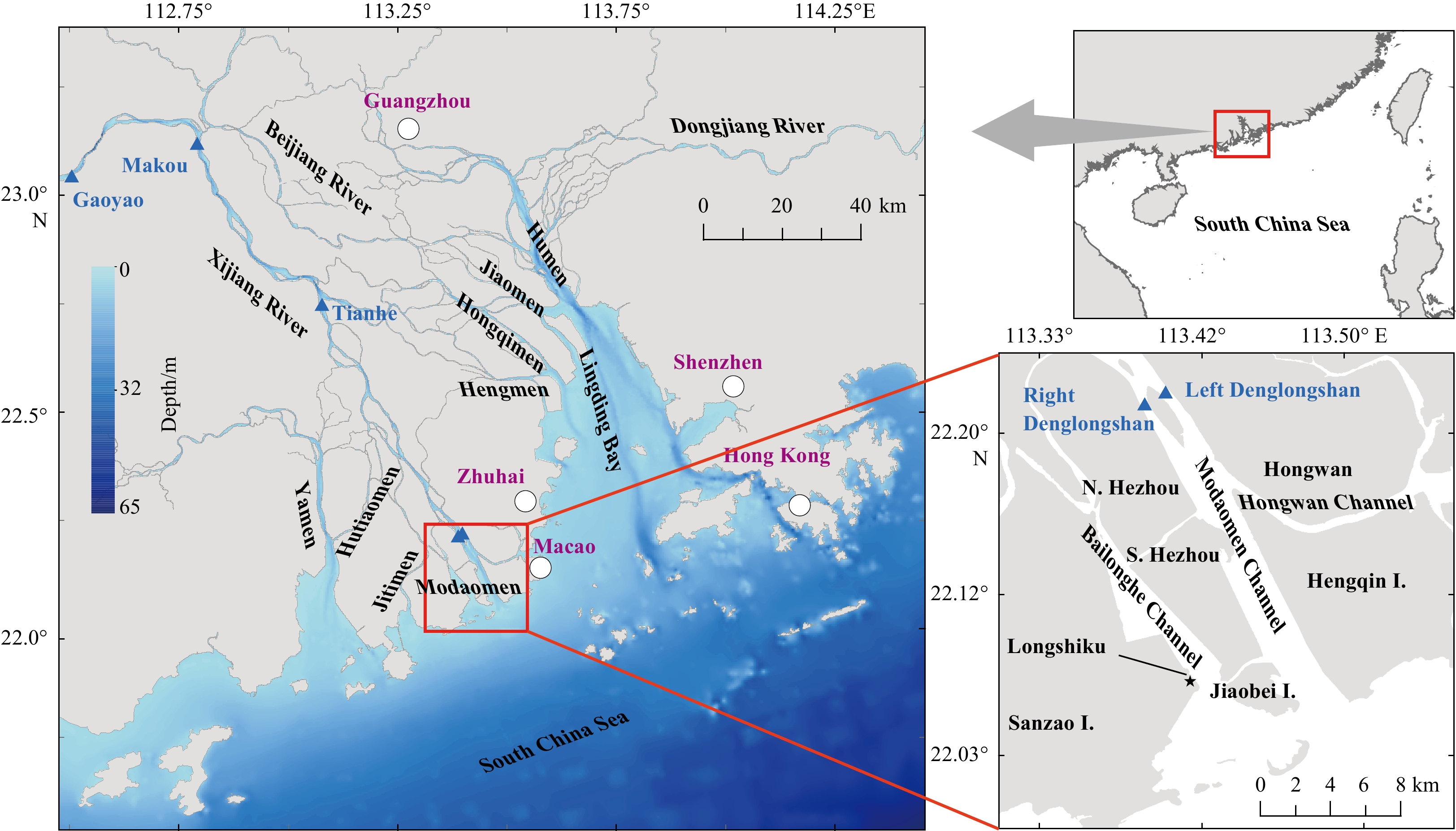
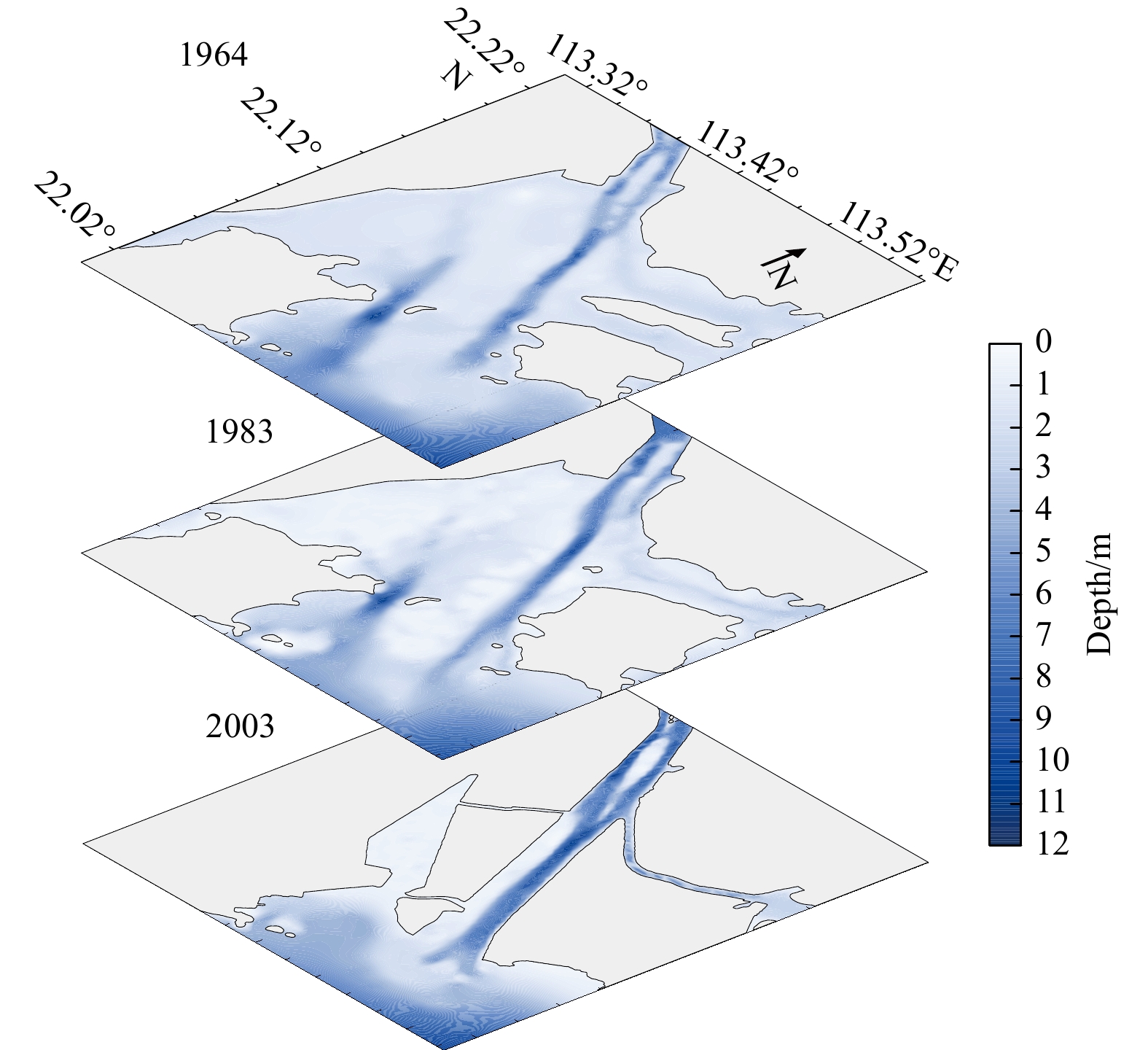
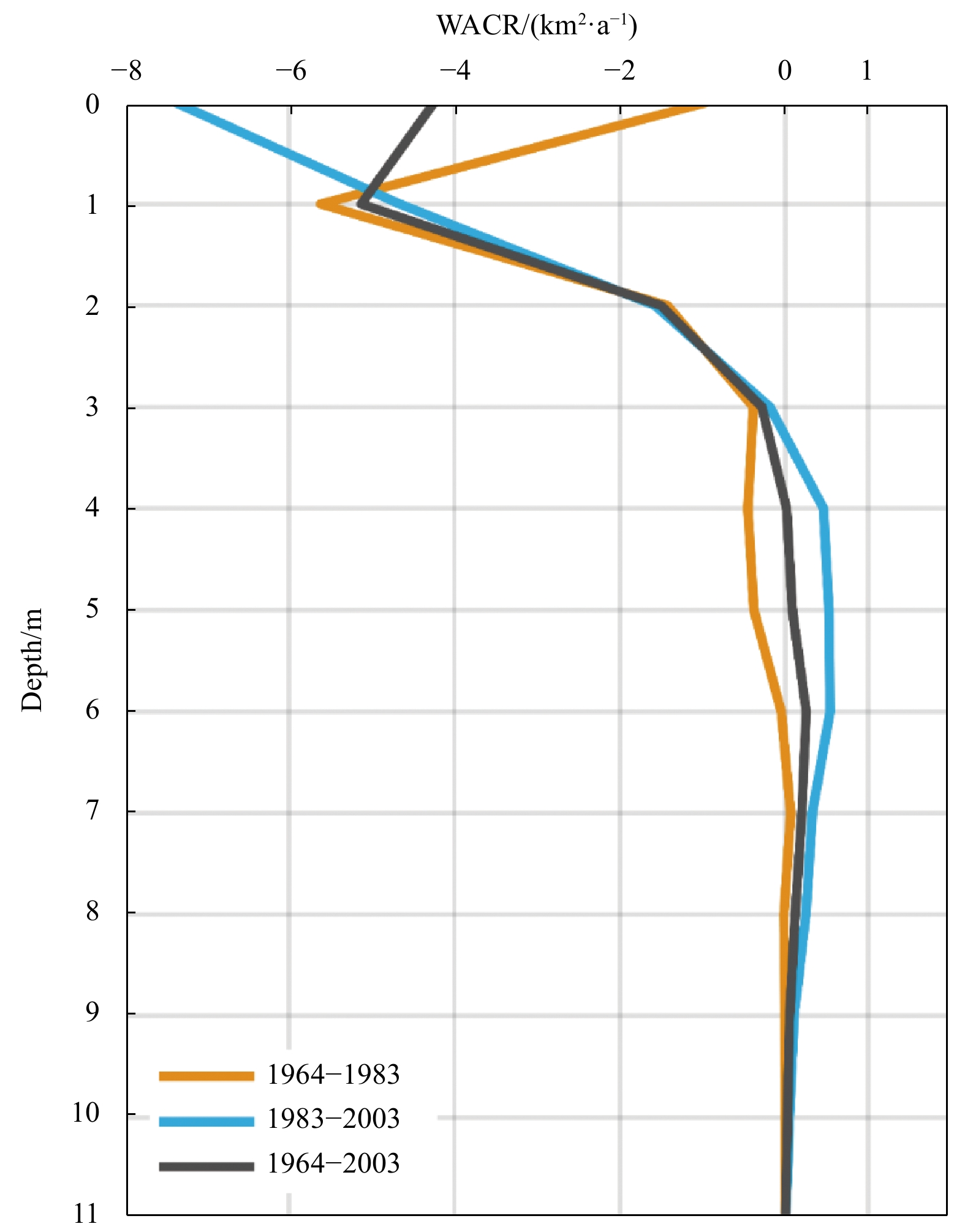
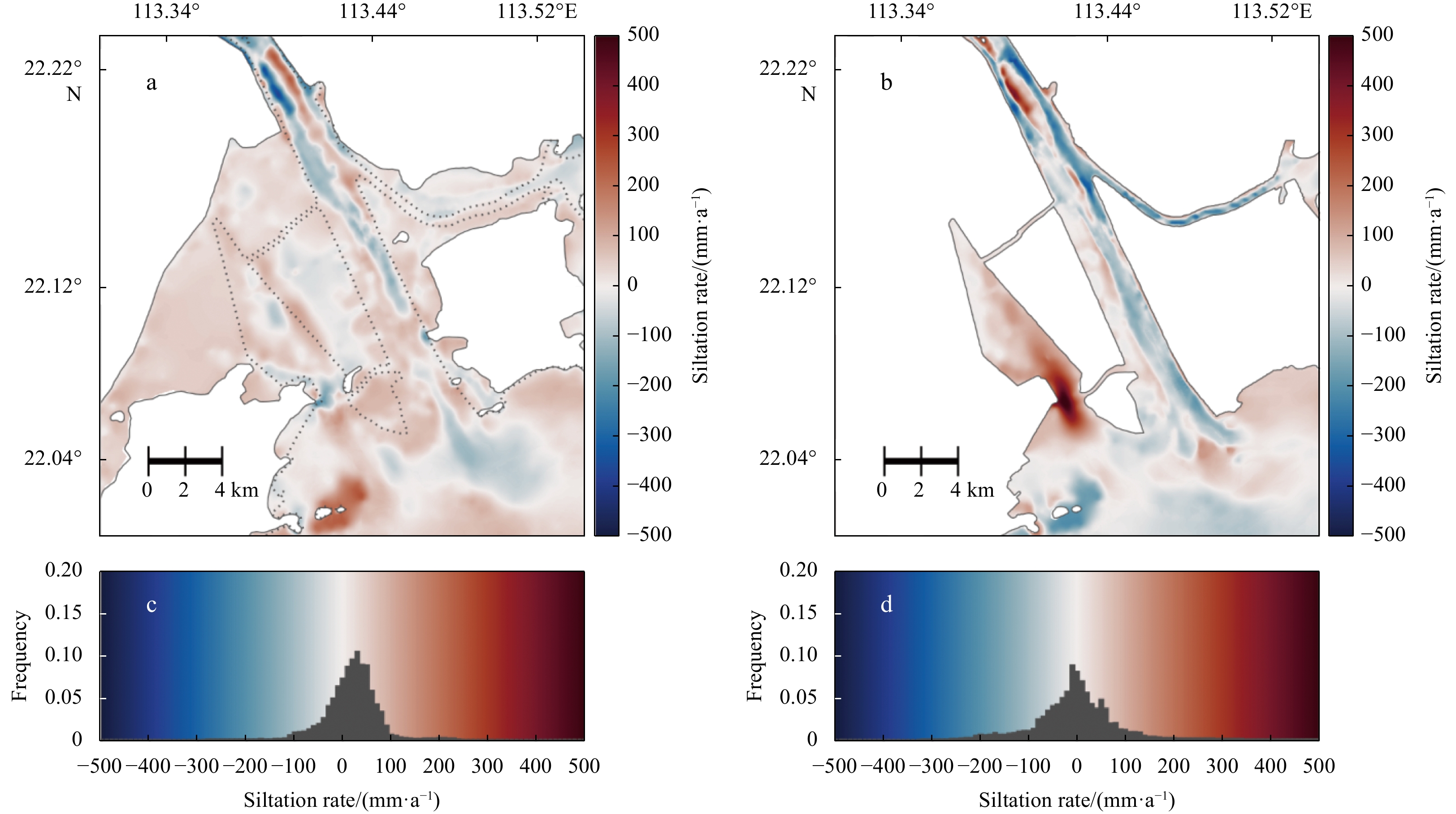
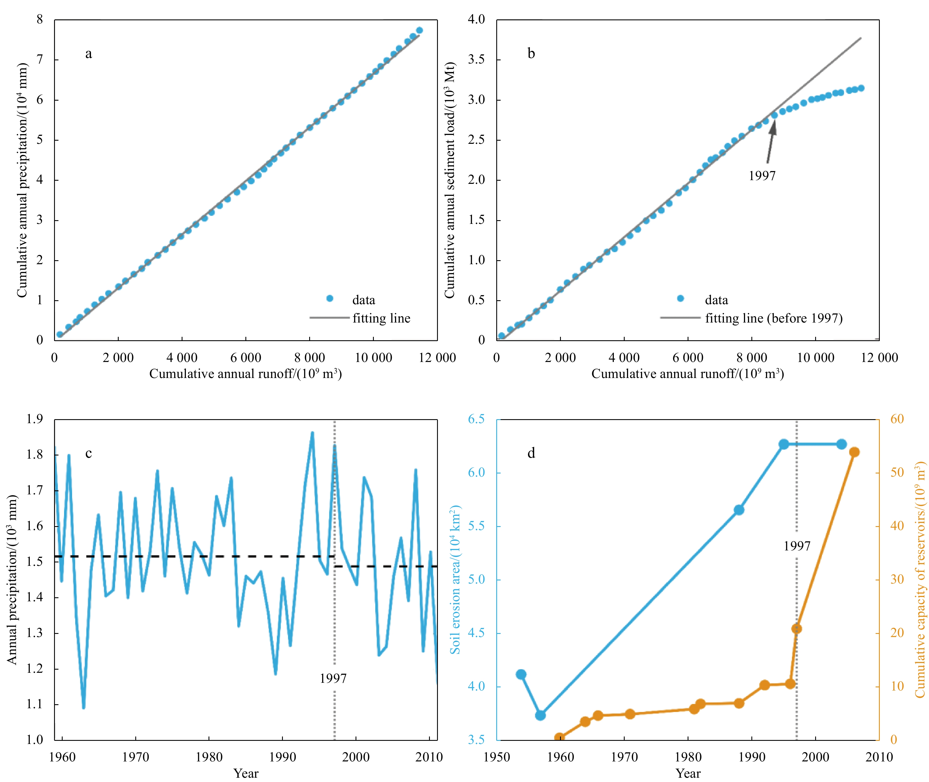
2023, 42(5): 79-92.
doi: 10.1007/s13131-022-2064-7
Abstract:
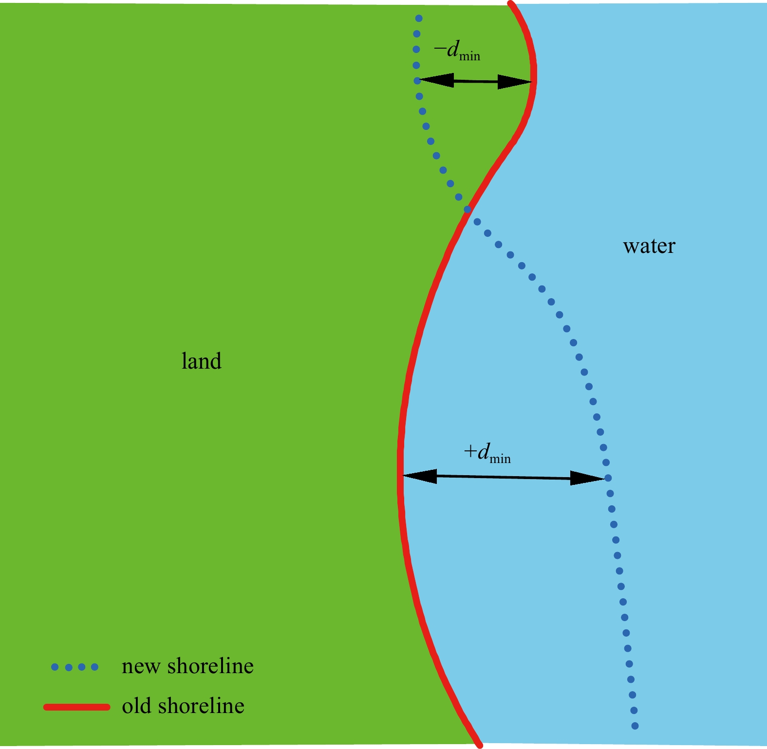
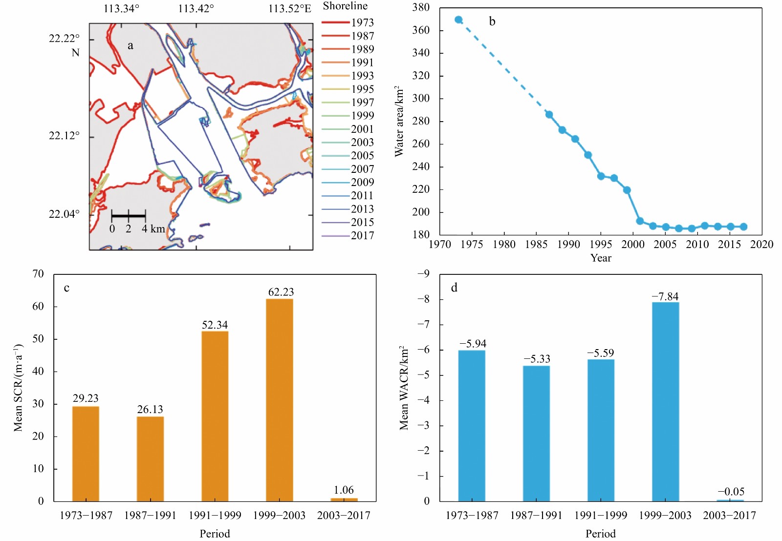
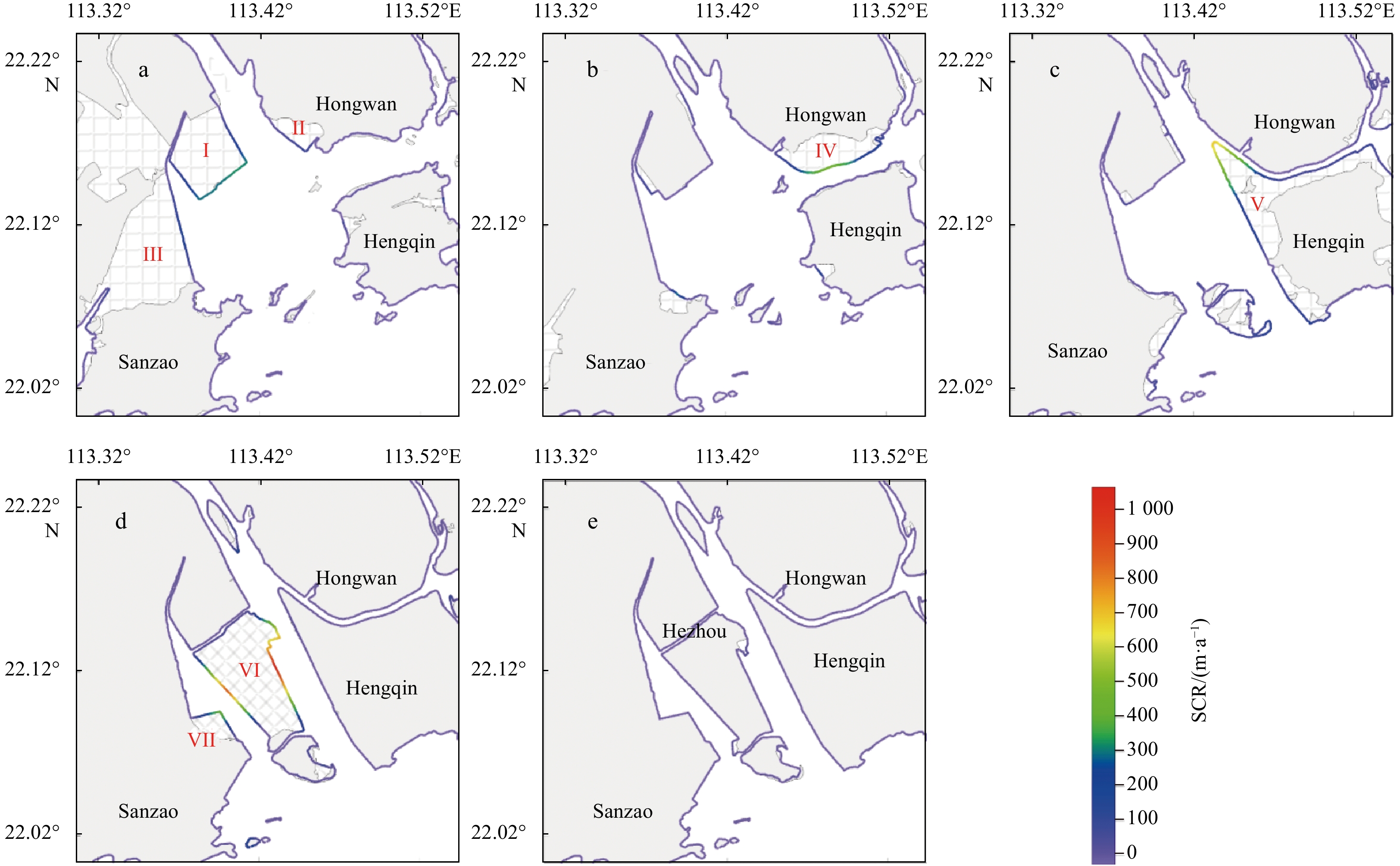
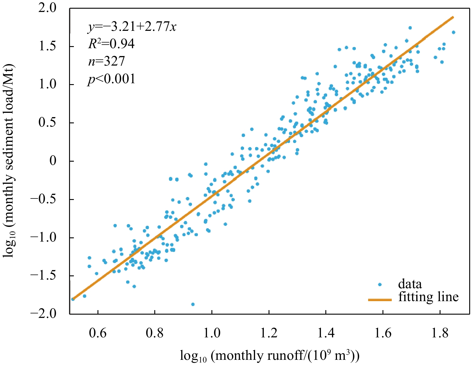
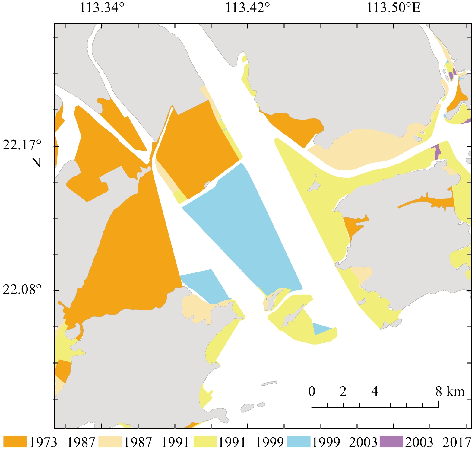
The morphology of the Modaomen Estuary (ME) has undergone drastic changes in recent decades, and quantifying the contribution of human activities and natural processes is crucial for estuary management. Using Landsat images, chart data, and hydrological and meteorological data, this study analyzed the evolution of the shoreline and subaqueous topography of the ME and attempted to quantify the extent of the contributions of human activities. The results show that local human activities dominated morphological evolution in some periods. From 1973 to 2003, the shoreline advanced rapidly seaward, resulting in approximately half of the water area being converted into land. Human activity is critical to this process, with the direct contribution of local land reclamation projects reaching more than 85%. After 2003, the shoreline remained relatively stable, probably due to a decrease in land reclamation projects. Regarding the evolution of subaqueous topography, the shoals in the estuary were heavily silted and gradually disappeared during 1983–2003, and the waterways narrowed and deepened. The average siltation rate decreased from 15.43 mm/a to −1.02 mm/a, indicating that the ME changed from sedimentation to slight erosion. By detecting variations of sediment load, we found that upstream human activities reduced river sediment, while downstream human activities significantly increased sediment input to the ME, leaving little change in the actual sediment input to the ME for a relatively long period. In addition, based on the empirical relationship between the sediment input and siltation rate, local human activities influenced the shift in the siltation state more than upstream and downstream human activities did. These findings suggest that more attention should be paid to local human activities to improve the estuarine management in the ME.
The morphology of the Modaomen Estuary (ME) has undergone drastic changes in recent decades, and quantifying the contribution of human activities and natural processes is crucial for estuary management. Using Landsat images, chart data, and hydrological and meteorological data, this study analyzed the evolution of the shoreline and subaqueous topography of the ME and attempted to quantify the extent of the contributions of human activities. The results show that local human activities dominated morphological evolution in some periods. From 1973 to 2003, the shoreline advanced rapidly seaward, resulting in approximately half of the water area being converted into land. Human activity is critical to this process, with the direct contribution of local land reclamation projects reaching more than 85%. After 2003, the shoreline remained relatively stable, probably due to a decrease in land reclamation projects. Regarding the evolution of subaqueous topography, the shoals in the estuary were heavily silted and gradually disappeared during 1983–2003, and the waterways narrowed and deepened. The average siltation rate decreased from 15.43 mm/a to −1.02 mm/a, indicating that the ME changed from sedimentation to slight erosion. By detecting variations of sediment load, we found that upstream human activities reduced river sediment, while downstream human activities significantly increased sediment input to the ME, leaving little change in the actual sediment input to the ME for a relatively long period. In addition, based on the empirical relationship between the sediment input and siltation rate, local human activities influenced the shift in the siltation state more than upstream and downstream human activities did. These findings suggest that more attention should be paid to local human activities to improve the estuarine management in the ME.

2023, 42(5): 93-101.
doi: 10.1007/s13131-022-2121-2
Abstract:
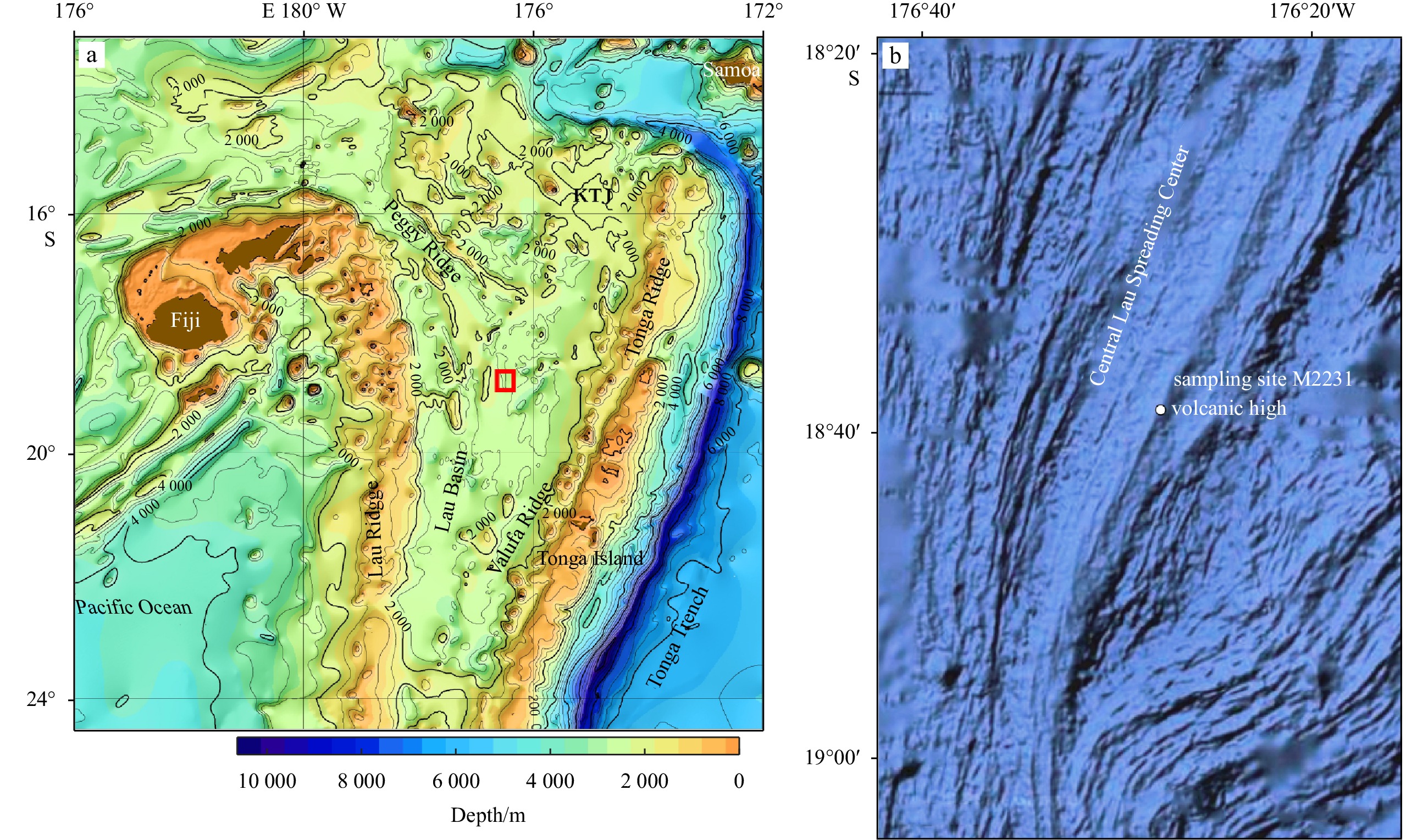
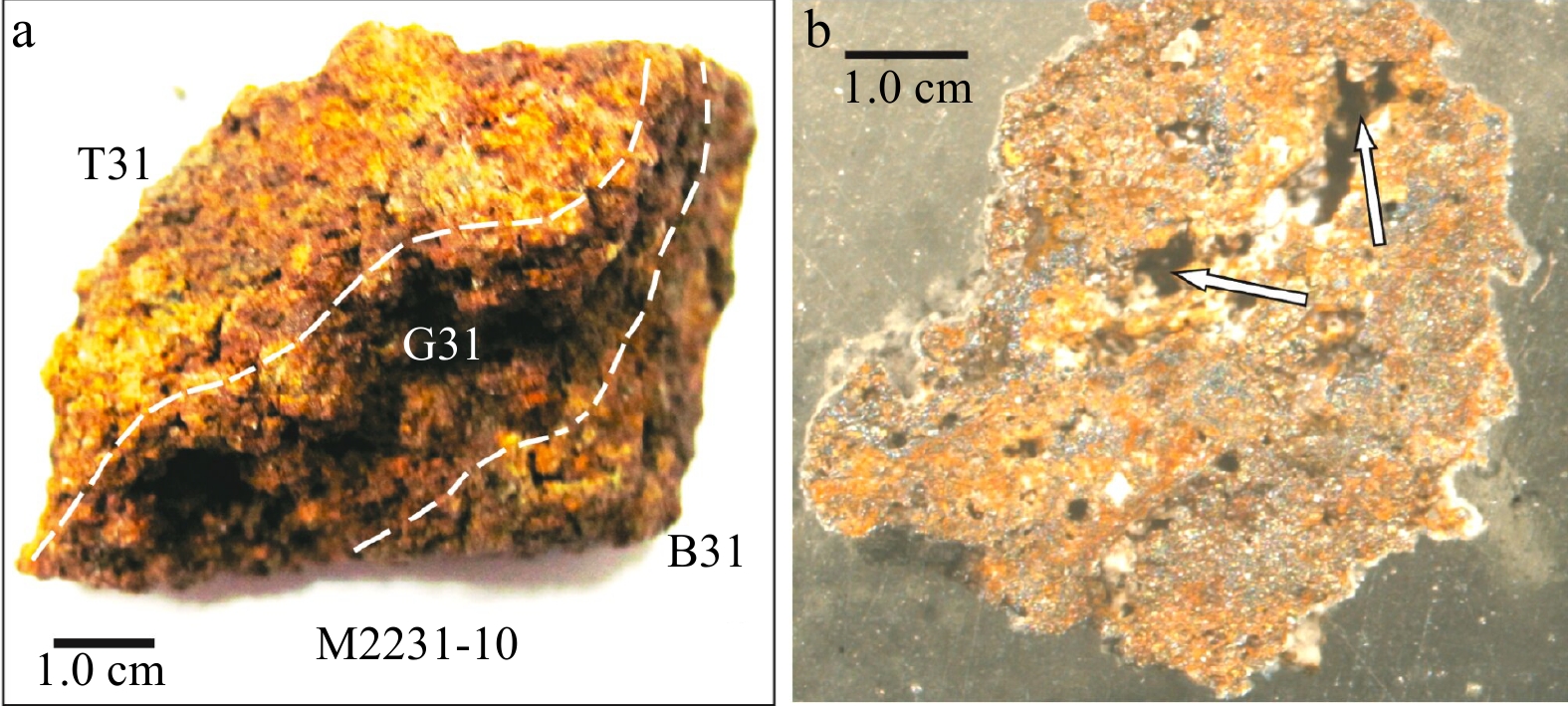
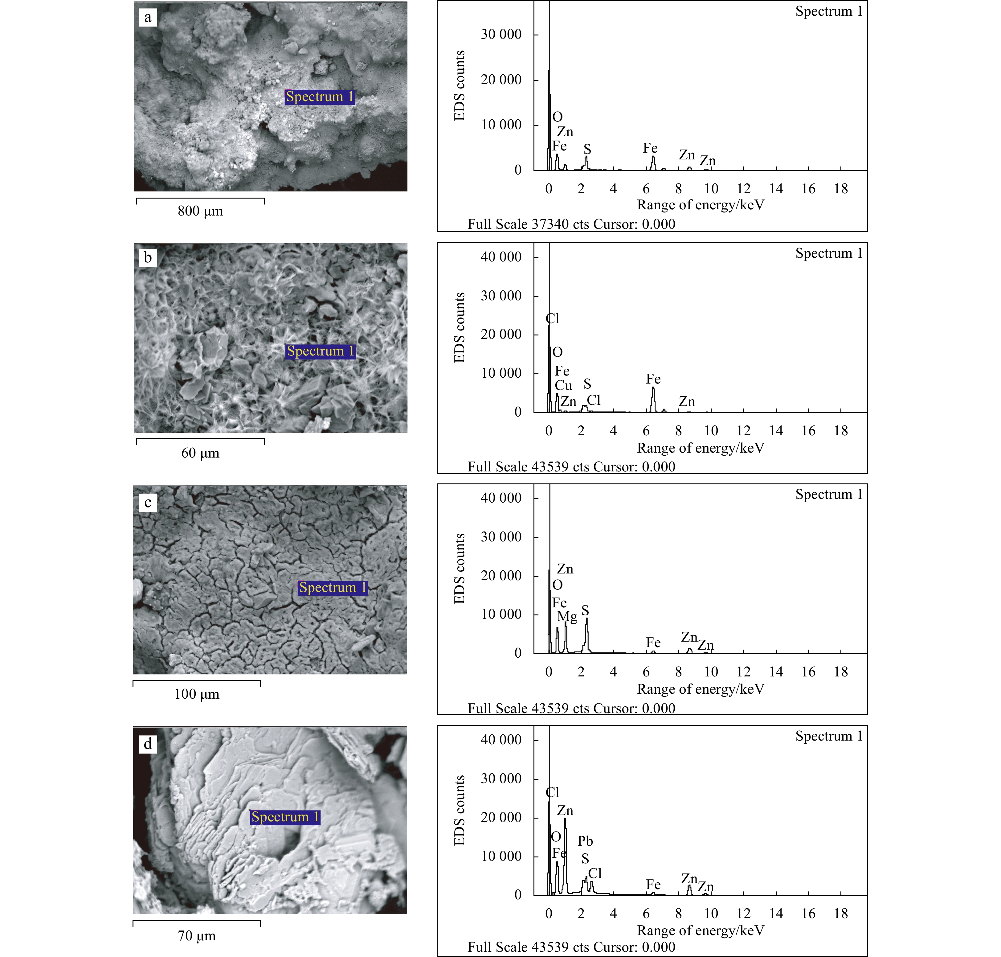
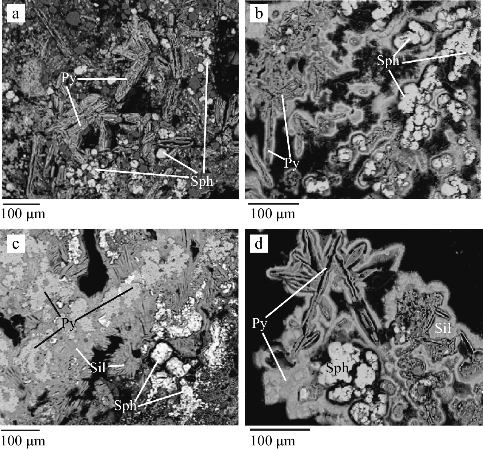
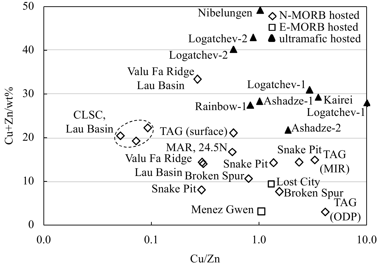
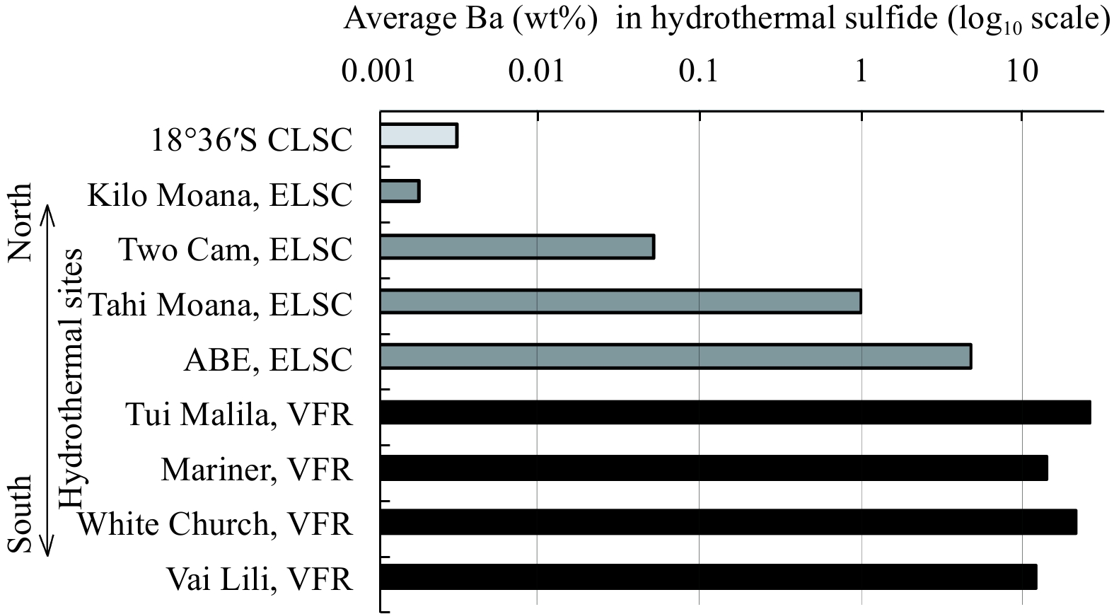
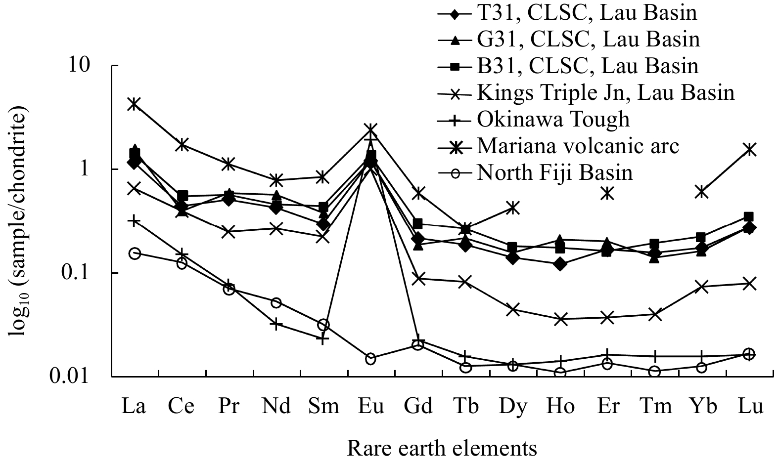
We report the mineralogy and geochemistry of hydrothermal sulphide from the crater of a volcanic high near 18°36.4′S of the Central Lau Spreading Center. During 1990s, that volcanic structure was reported active and sulphide samples were collected by MIR submersible. A section of a chimney-like structure from the crater-floor was studied here. The Fe-depleted sphalerites, and Co-depleted pyrites in that chimney were similar to those commonly found in low to moderate temperature (<300℃) sulphides from sediment-starved hydrothermal systems. Bulk analyses of three parts of that chimney section showed substantial enrichment of Zn (18%–20%) and Fe (14%–27%) but depletion of Cu (0.8%–1.3%). In chondrite-normalized rare earth element-patterns, the significant negative Ce-anomalies (Ce/Ce*=0.27–0.39) and weakly positive Eu-anomalies (Eu/Eu*=1.60–1.68) suggested sulphide mineralisation took place from reduced low-temperature fluid. The depleted concentration of lithophiles in this sulphide indicates restricted contribution of sub-ducting plate in genesis of source fluid as compared to those from other parts of Lau Spreading Centre. Uniform mineralogy and bulk composition of subsamples across the chimney section suggests barely any alteration of fluid composition and/or mode of mineralisation occurred during its growth.
We report the mineralogy and geochemistry of hydrothermal sulphide from the crater of a volcanic high near 18°36.4′S of the Central Lau Spreading Center. During 1990s, that volcanic structure was reported active and sulphide samples were collected by MIR submersible. A section of a chimney-like structure from the crater-floor was studied here. The Fe-depleted sphalerites, and Co-depleted pyrites in that chimney were similar to those commonly found in low to moderate temperature (<300℃) sulphides from sediment-starved hydrothermal systems. Bulk analyses of three parts of that chimney section showed substantial enrichment of Zn (18%–20%) and Fe (14%–27%) but depletion of Cu (0.8%–1.3%). In chondrite-normalized rare earth element-patterns, the significant negative Ce-anomalies (Ce/Ce*=0.27–0.39) and weakly positive Eu-anomalies (Eu/Eu*=1.60–1.68) suggested sulphide mineralisation took place from reduced low-temperature fluid. The depleted concentration of lithophiles in this sulphide indicates restricted contribution of sub-ducting plate in genesis of source fluid as compared to those from other parts of Lau Spreading Centre. Uniform mineralogy and bulk composition of subsamples across the chimney section suggests barely any alteration of fluid composition and/or mode of mineralisation occurred during its growth.
2023, 42(5): 102-116.
doi: 10.1007/s13131-022-2062-9
Abstract:
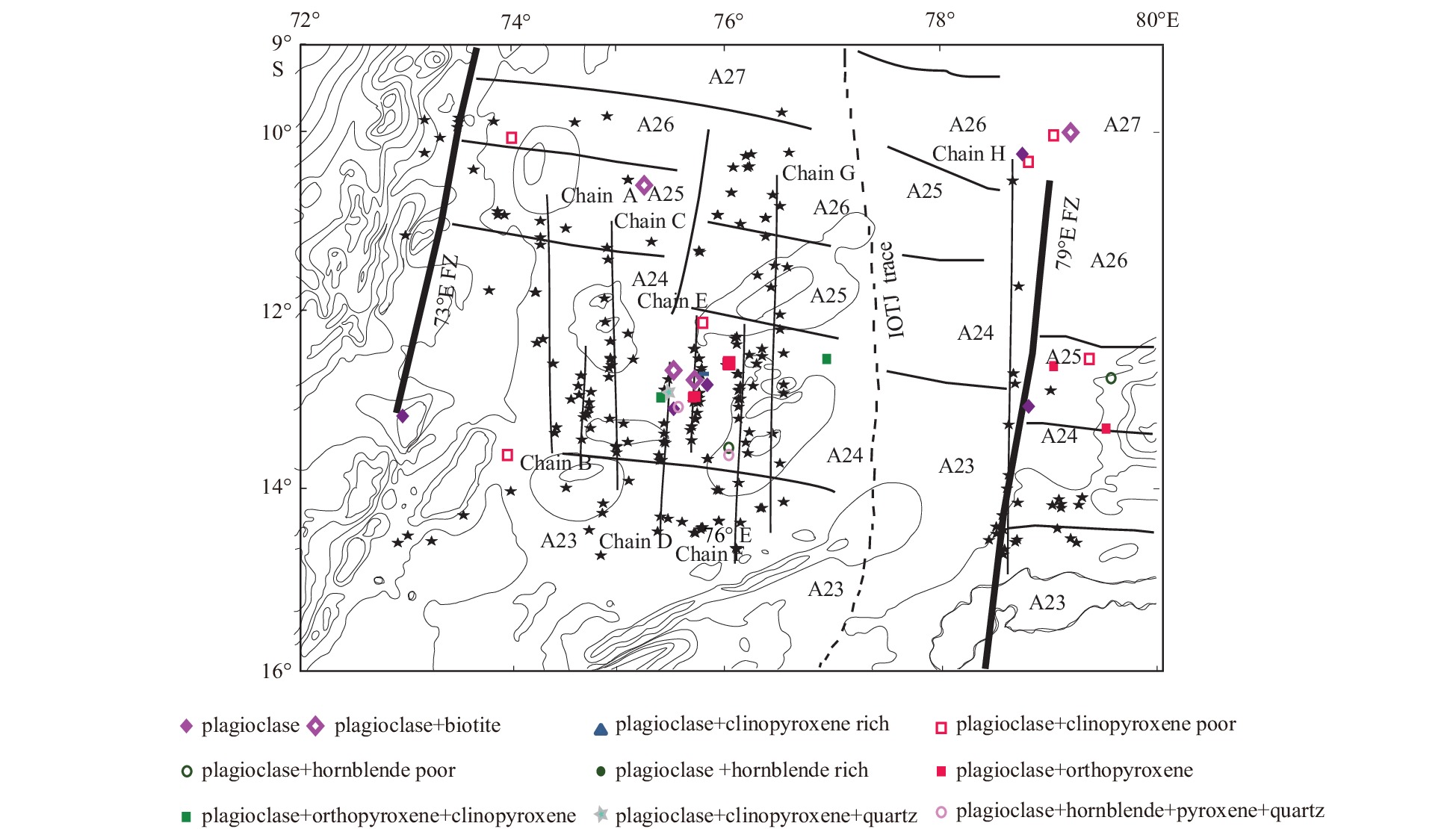
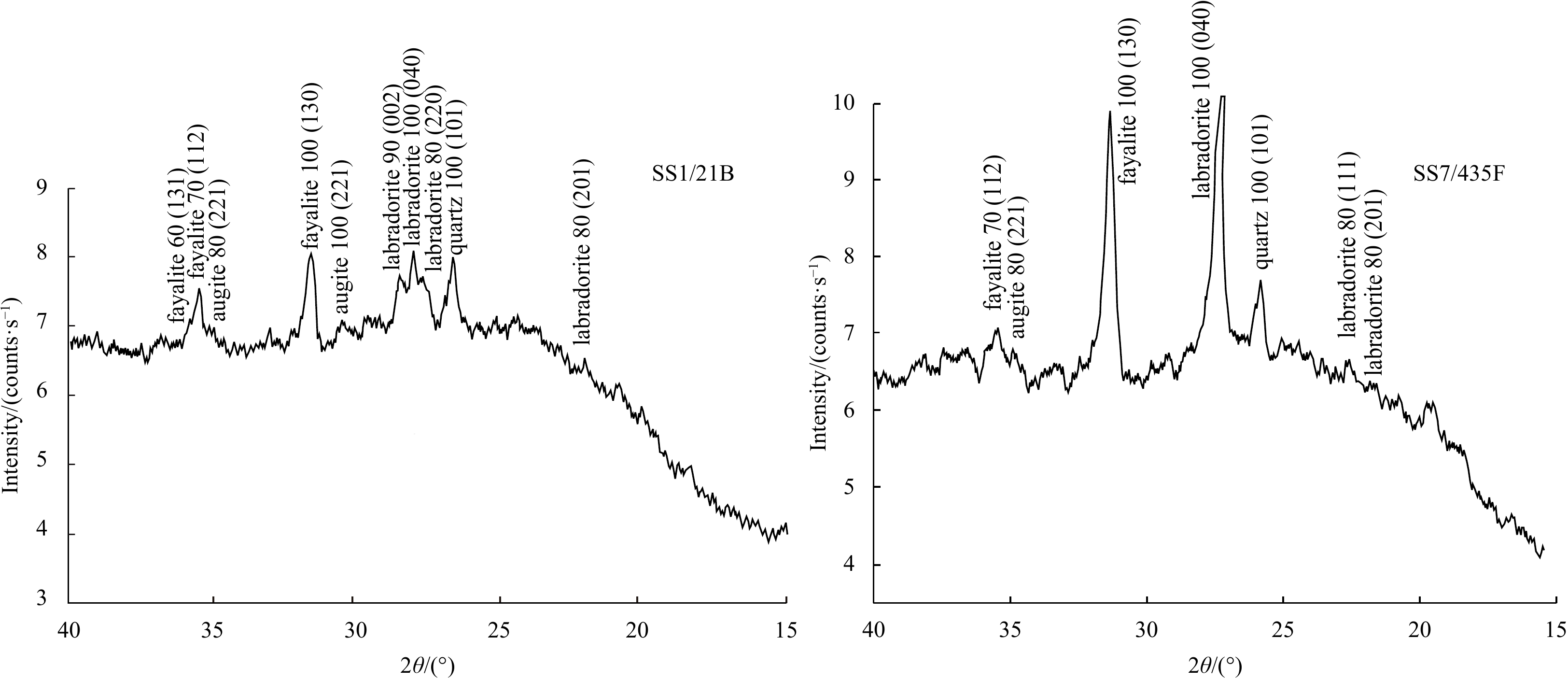
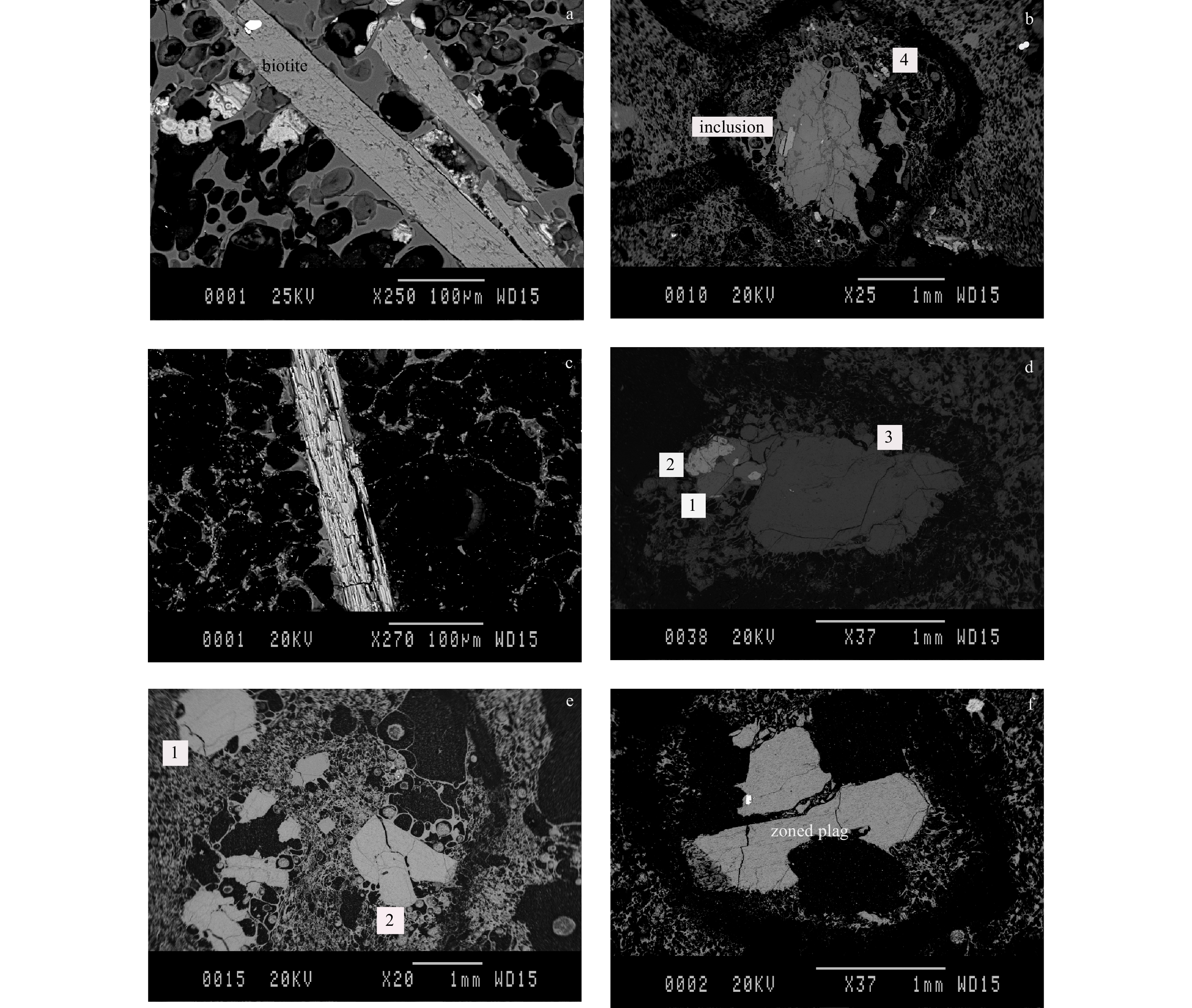
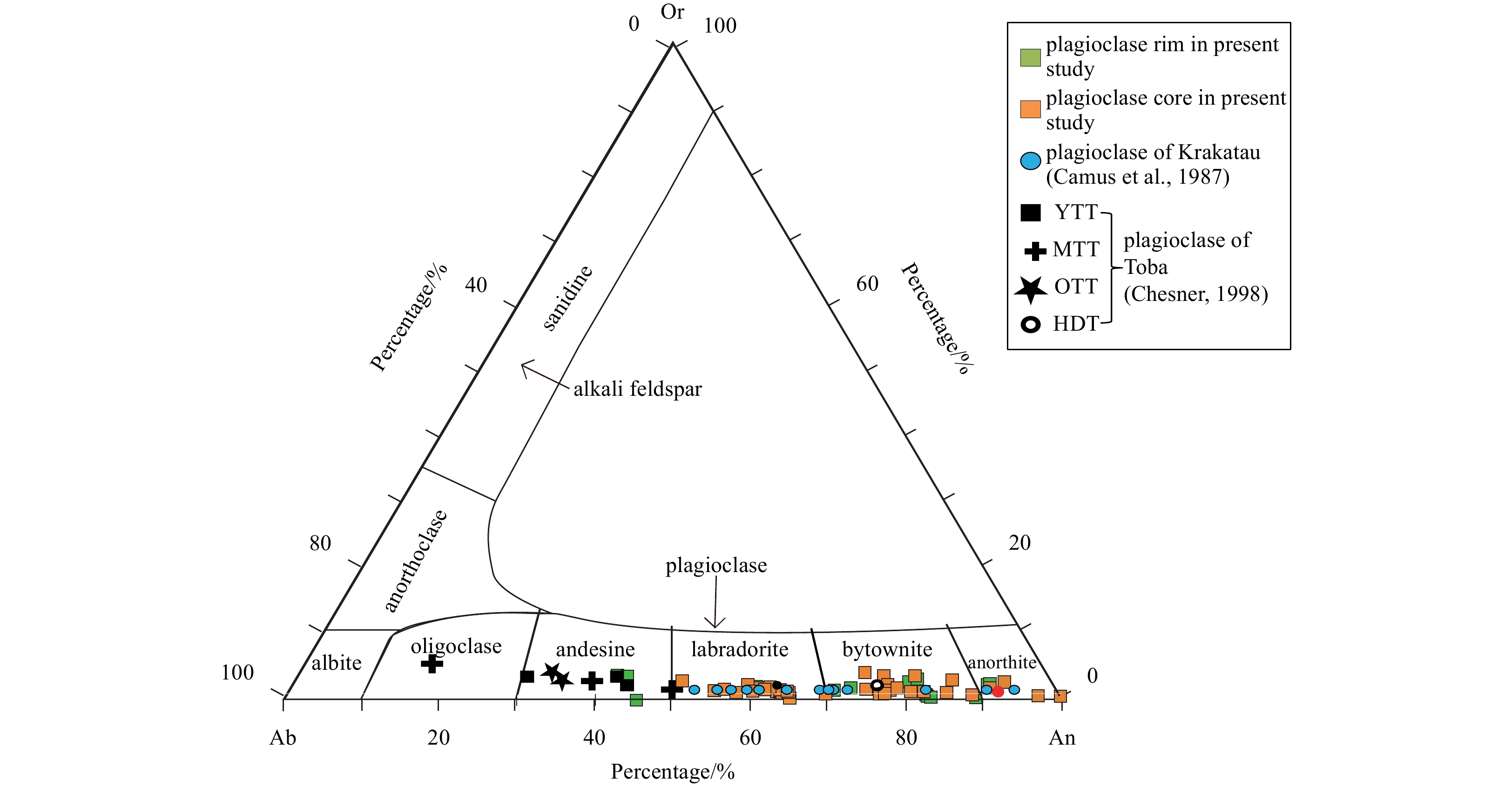
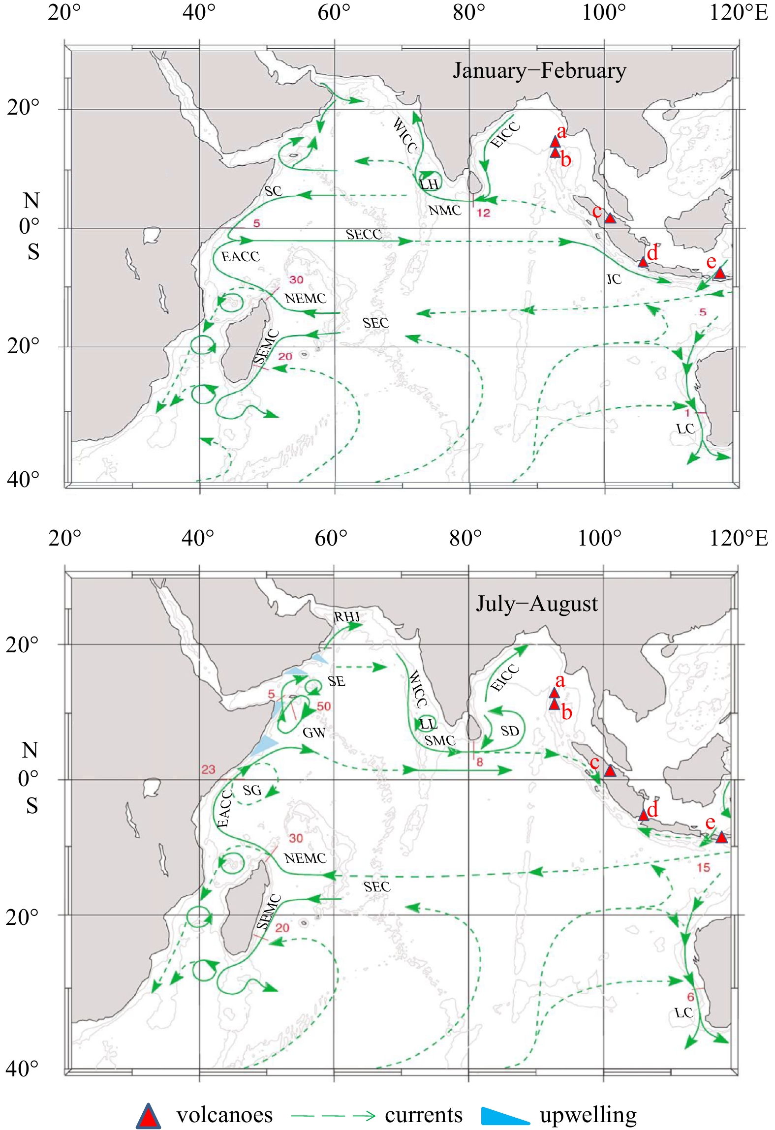
We present data pertaining to mineral assemblages and composition of the Central Indian Ocean Basin (CIOB) pumices. Eight groups of pumices were identified considering the presence of phenocrysts of plagioclase, clinopyroxene, orthopyroxene, hornblende and biotite together with the occurrence of quartz and glass. Pigeonite, fayalite and ulvospinelare reported for the first time from these pumices. In the eight groups, the modal percentage of the constituents are phenocrysts 3% to 19% (avg 9.6%), silicic glass 33% to 54% (avg 43%) and the rest is vesicles. Based on the above factors we have identified the possible sources of the CIOB pumices. The mineral compositions of plagioclase, pyroxenes, and biotite of the CIOB pumices were compared with those of Krakatau and Toba. Most of the plagioclase and pyroxene compositions resemble the Haranggoal Dacite Tuff of Toba and Krakatau. Considering the mineral assemblages and compositions, there are pumices which do not correlate to any of the above eruptions and are probably from yet unidentified source/sources. These sources could either be from nearby terrestrial volcanoes or intraplate seamounts present in the CIOB. In a global context, it is viable that petrological characteristics could be used as initial criteria to determine the source of pumices that occur at abyssal depths in the world ocean.
We present data pertaining to mineral assemblages and composition of the Central Indian Ocean Basin (CIOB) pumices. Eight groups of pumices were identified considering the presence of phenocrysts of plagioclase, clinopyroxene, orthopyroxene, hornblende and biotite together with the occurrence of quartz and glass. Pigeonite, fayalite and ulvospinelare reported for the first time from these pumices. In the eight groups, the modal percentage of the constituents are phenocrysts 3% to 19% (avg 9.6%), silicic glass 33% to 54% (avg 43%) and the rest is vesicles. Based on the above factors we have identified the possible sources of the CIOB pumices. The mineral compositions of plagioclase, pyroxenes, and biotite of the CIOB pumices were compared with those of Krakatau and Toba. Most of the plagioclase and pyroxene compositions resemble the Haranggoal Dacite Tuff of Toba and Krakatau. Considering the mineral assemblages and compositions, there are pumices which do not correlate to any of the above eruptions and are probably from yet unidentified source/sources. These sources could either be from nearby terrestrial volcanoes or intraplate seamounts present in the CIOB. In a global context, it is viable that petrological characteristics could be used as initial criteria to determine the source of pumices that occur at abyssal depths in the world ocean.


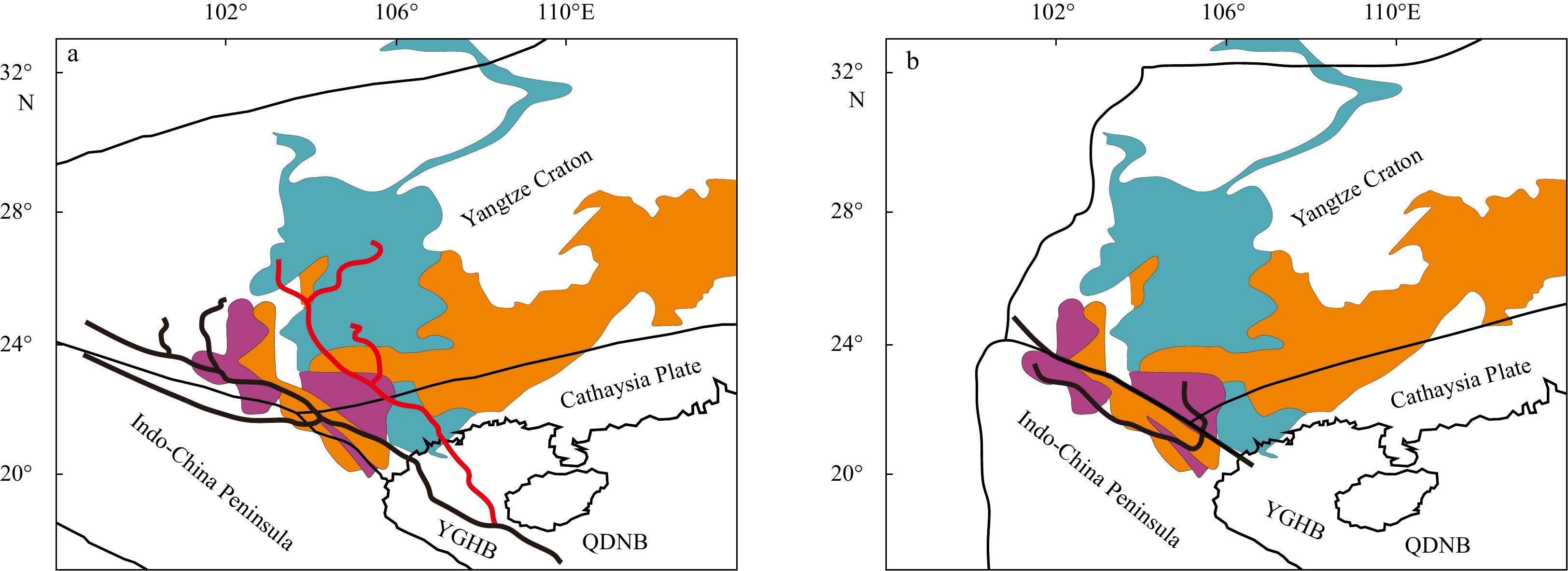
2023, 42(5): 117-129.
doi: 10.1007/s13131-022-2069-2
Abstract:
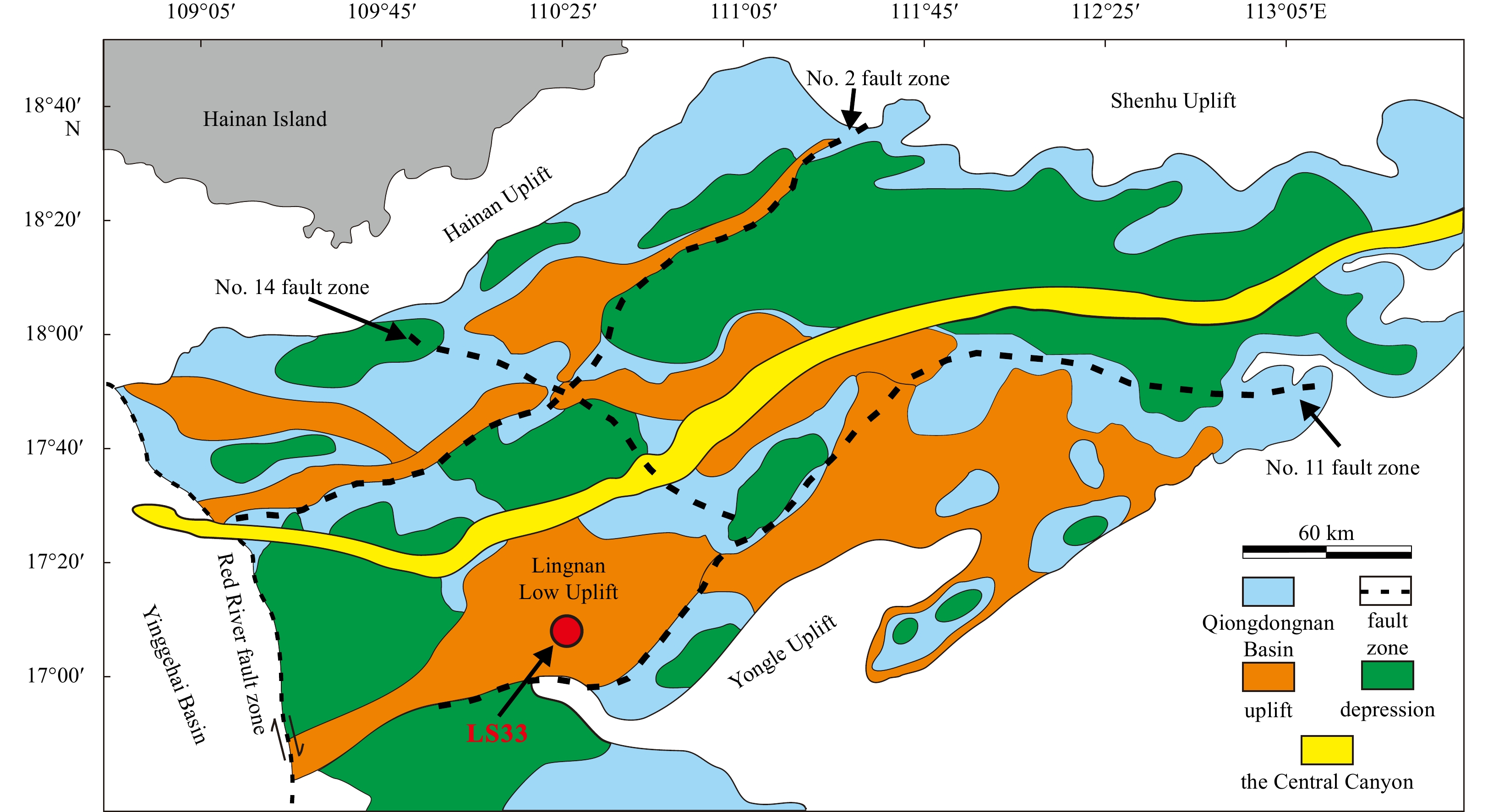
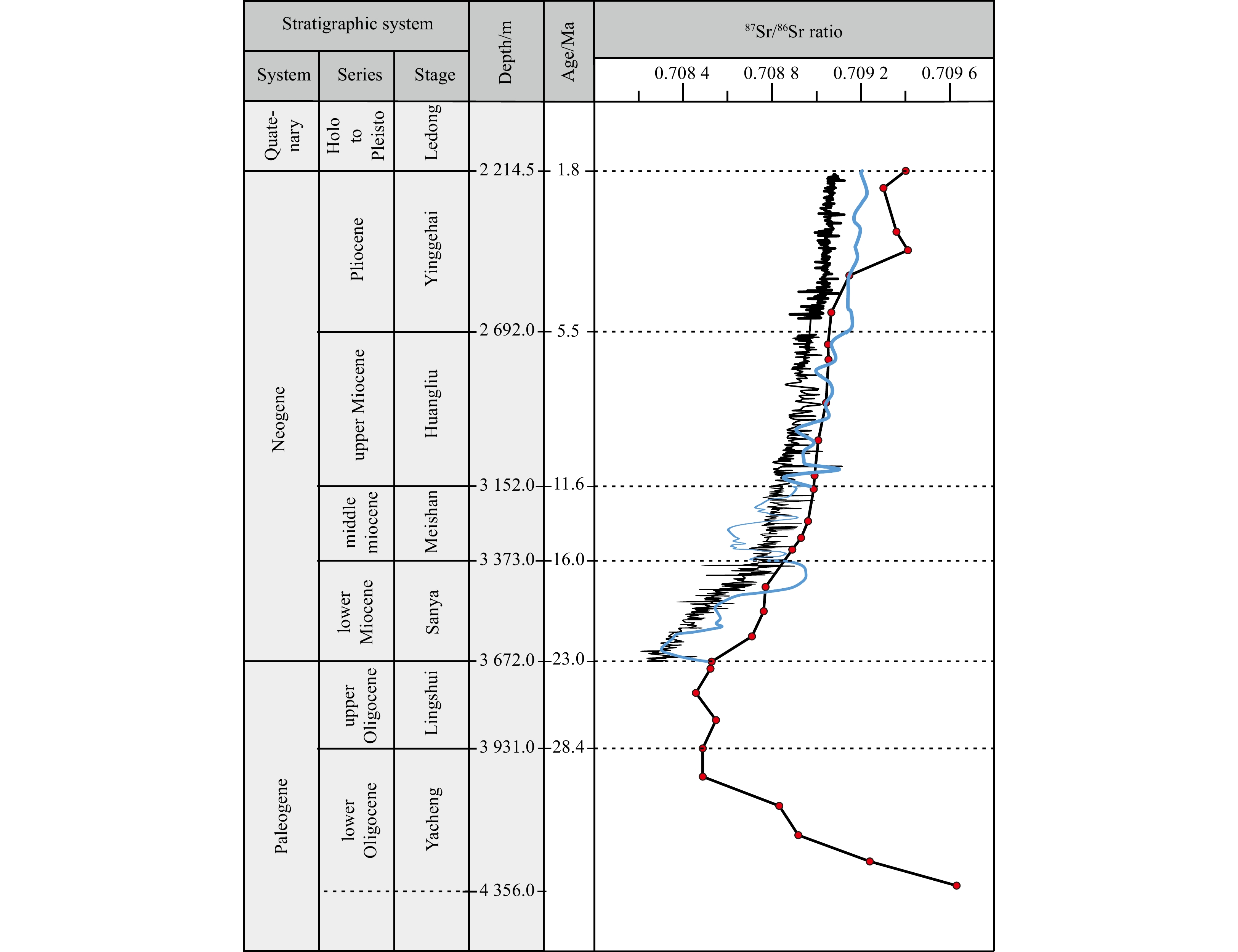
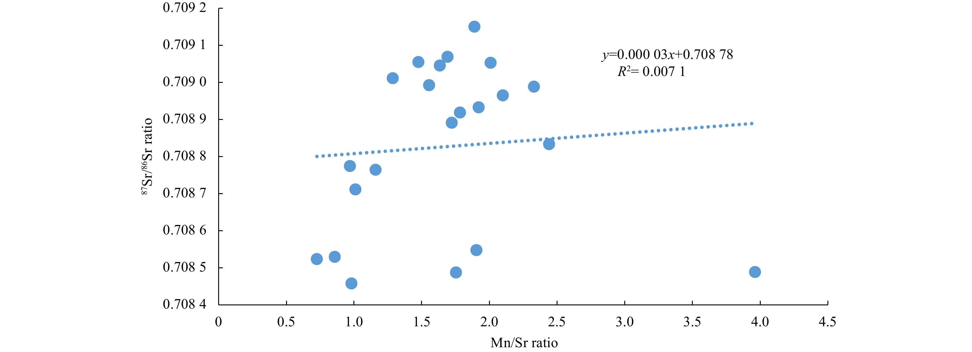
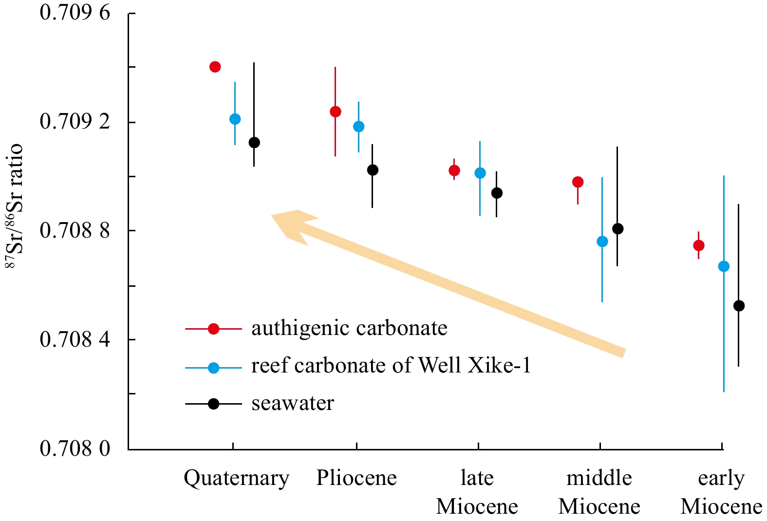
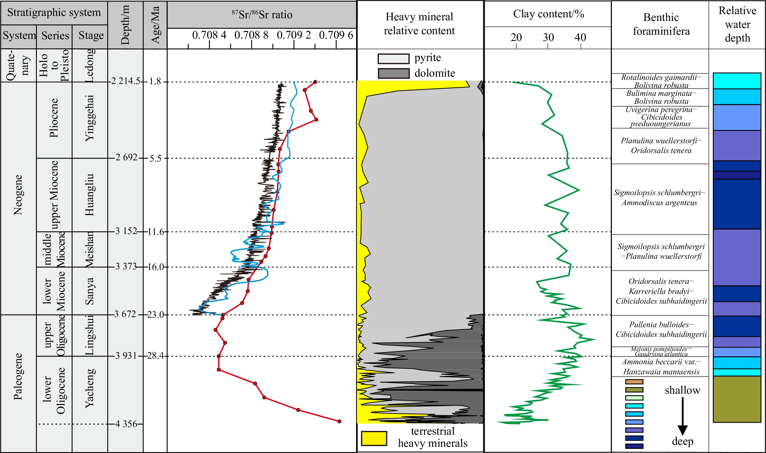
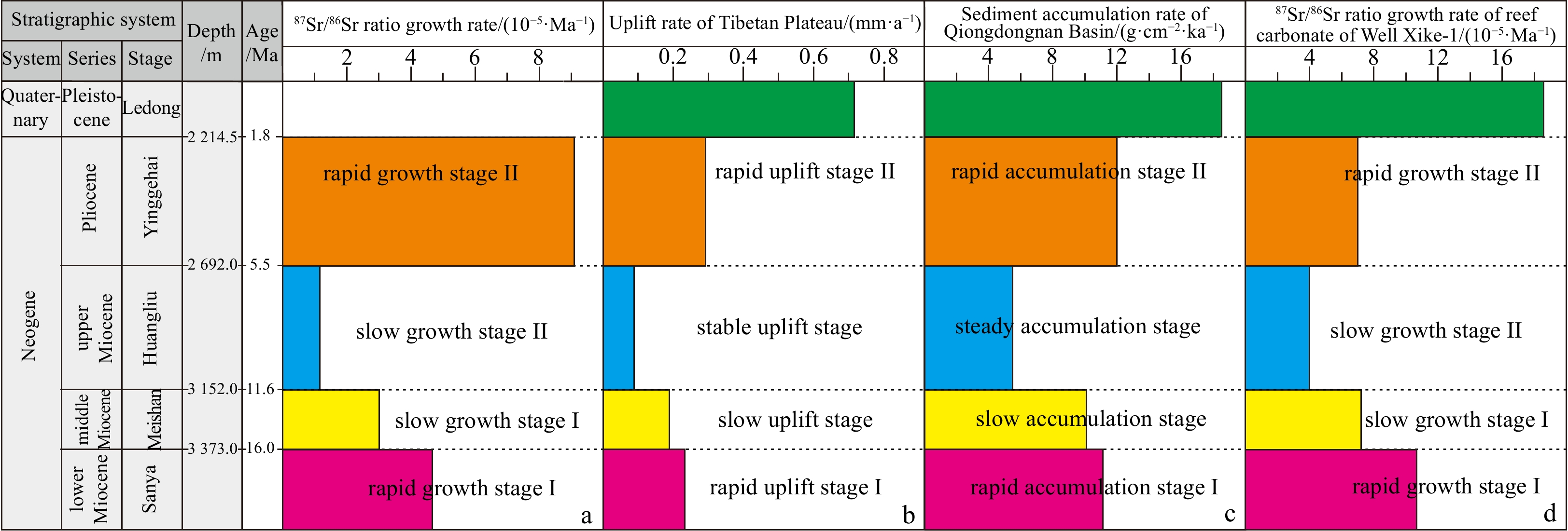
Making full use of modern analytical and testing techniques to explore and establish new indexes or methods for extracting paleoseawater geochemical information from sediments will help to reconstruct the sedimentary paleoenvironment in different research areas. The connection between the subsidence of the South China Sea basin and the uplift of the Tibetan Plateau has been a scientific concern in recent decades. To explore the information on the sedimentary paleoenvironment, provenance changes and uplift of Tibetan Plateau contained in core sediments (debris), we selected core samples from Well LS33 in the Qiongdongnan Basin, South China Sea, and analyzed the contents of typical elements (Al, Th, and rare earth elements) that can indicate changes in provenance and the Sr isotopic compositions, which can reveal the geochemical characteristics of the paleoseawater depending on the type of material (authigenic carbonate and terrigenous detritus). The results show the following: (1) during the late Miocene, the Red River transported a large amount of detrital sediments from the ancient continental block (South China) to the Qiongdongnan Basin. (2) The authigenic carbonates accurately record changes in the 87Sr/86Sr ratios in the South China Sea since the Oligocene. These ratios reflect the semi-closed marginal sea environment of the South China Sea (relative to the ocean) and the sedimentary paleoenvironment evolution process of the deep-water area of the Qiongdongnan Basin from continental to transitional and then to bathyal. (3) Since the Neogene, the variations in the 87Sr/86Sr ratio in the authigenic carbonates have been consistent with the variations in the uplift rate of the Tibetan Plateau and the sediment accumulation rate in the Qiongdongnan Basin. These consistent changes indicate the complex geological process of the change in the rock weathering intensity and terrigenous Sr flux caused by changes in the uplift rate of the Tibetan Plateau, which influence the Sr isotope composition of seawater.
Making full use of modern analytical and testing techniques to explore and establish new indexes or methods for extracting paleoseawater geochemical information from sediments will help to reconstruct the sedimentary paleoenvironment in different research areas. The connection between the subsidence of the South China Sea basin and the uplift of the Tibetan Plateau has been a scientific concern in recent decades. To explore the information on the sedimentary paleoenvironment, provenance changes and uplift of Tibetan Plateau contained in core sediments (debris), we selected core samples from Well LS33 in the Qiongdongnan Basin, South China Sea, and analyzed the contents of typical elements (Al, Th, and rare earth elements) that can indicate changes in provenance and the Sr isotopic compositions, which can reveal the geochemical characteristics of the paleoseawater depending on the type of material (authigenic carbonate and terrigenous detritus). The results show the following: (1) during the late Miocene, the Red River transported a large amount of detrital sediments from the ancient continental block (South China) to the Qiongdongnan Basin. (2) The authigenic carbonates accurately record changes in the 87Sr/86Sr ratios in the South China Sea since the Oligocene. These ratios reflect the semi-closed marginal sea environment of the South China Sea (relative to the ocean) and the sedimentary paleoenvironment evolution process of the deep-water area of the Qiongdongnan Basin from continental to transitional and then to bathyal. (3) Since the Neogene, the variations in the 87Sr/86Sr ratio in the authigenic carbonates have been consistent with the variations in the uplift rate of the Tibetan Plateau and the sediment accumulation rate in the Qiongdongnan Basin. These consistent changes indicate the complex geological process of the change in the rock weathering intensity and terrigenous Sr flux caused by changes in the uplift rate of the Tibetan Plateau, which influence the Sr isotope composition of seawater.


2023, 42(5): 130-138.
doi: 10.1007/s13131-022-2070-9
Abstract:
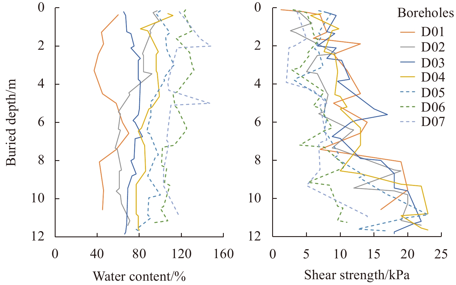
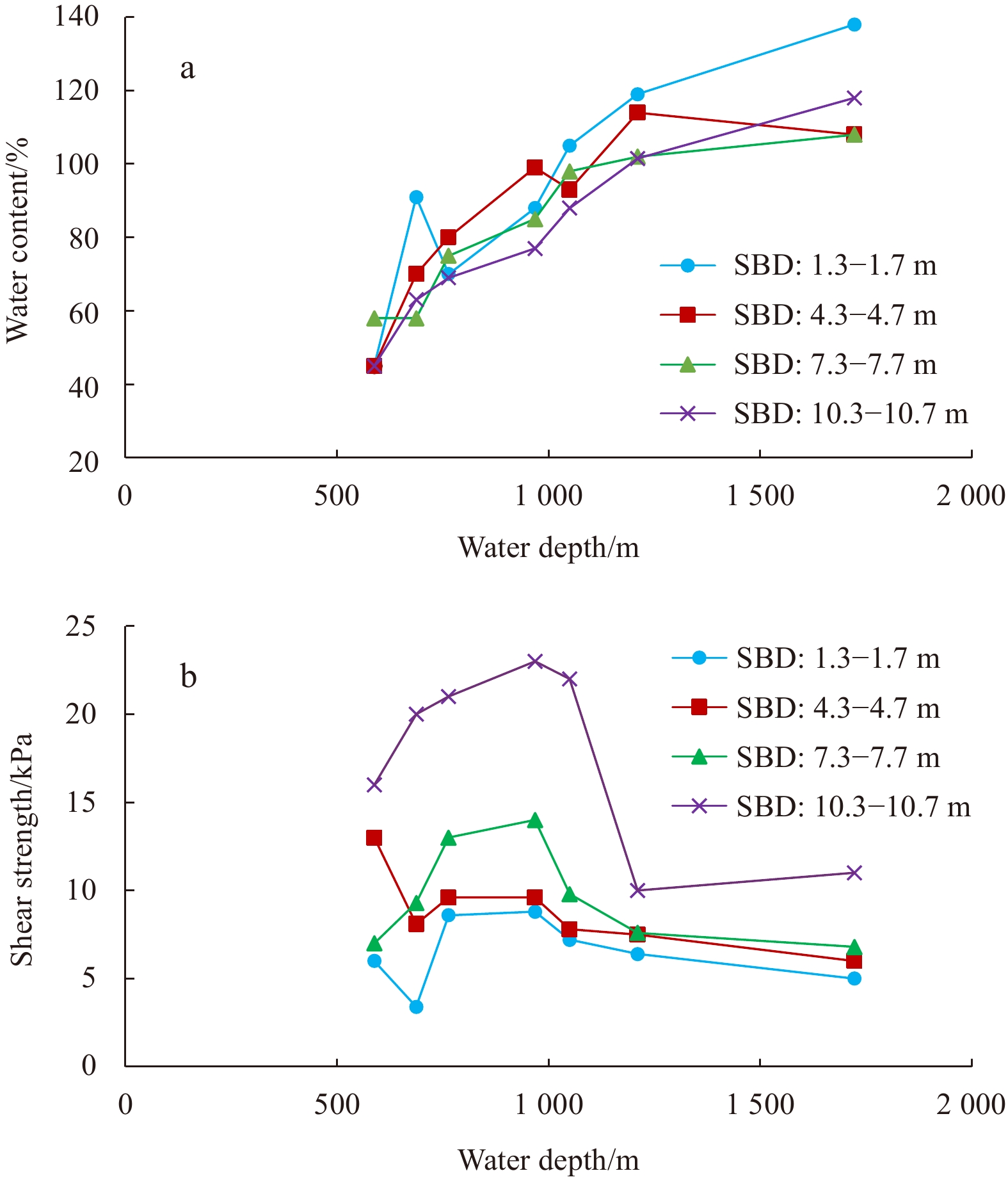
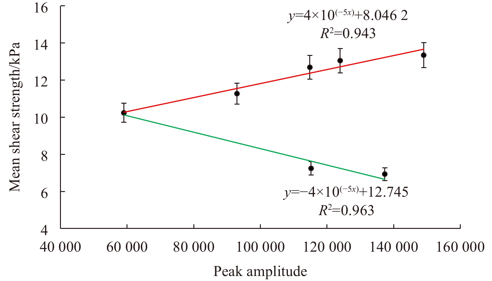
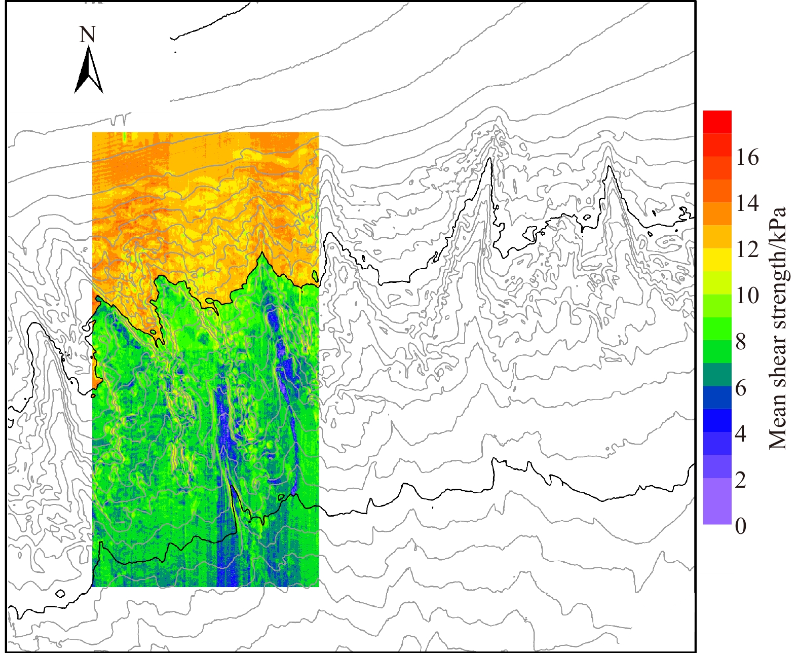
Before the implementation of offshore oil and gas exploitation, it is essential to understand the various factors that influence the stability of submarine sediments surrounding the project. Considering the factors such as cost and operability, it is not feasible to assess the physical-mechanical properties of sediments covering the entire region by borehole sampling. In this study, the correlation between near seafloor seismic amplitude and the mean shear strength of shallow sediments was explored using seismic and core testing data from the northern continental slope area of the South China Sea. Results showed that the mean water content of sediments in the layer up to 12 m below the seafloor (mbsf) gradually increased with increasing water depth, and the mean shear strength tended to decrease rapidly near the 1 000 m depth contour. The near seafloor seismic amplitude could reflect the mean shear strength of sediments in the 12 mbsf layer under seismic frequency of 65 Hz and wave velocity of 1 600 m/s. When the mean shear strength was greater than 10 kPa or the water depth was less than 1 000 m, there was a significant linear positive correlation between mean shear strength and near seafloor seismic amplitude. Otherwise, there was a significant linear negative correlation between mean shear strength and near seafloor seismic amplitude. On the basis of these correlations, the pattern of shear strength was estimated from near seafloor seismic amplitude and mapped. The mean shear strength of sediments above 12 mbsf gradually decreased with increasing water depth in the continental slope area, whereas little change occurred in the continental shelf and the end of the canyon. Within the canyon area, the mean shear strength of sediments was characterized by larger values in both sides of the canyon walls and smaller values in the canyon bottom, which was consistent with the infinite slope stability theory. The study provides a method for using near seafloor seismic amplitude data to guide sediment sampling design, and presents a continuous dataset of sediment strength for the simulation of regional sediment stability.
Before the implementation of offshore oil and gas exploitation, it is essential to understand the various factors that influence the stability of submarine sediments surrounding the project. Considering the factors such as cost and operability, it is not feasible to assess the physical-mechanical properties of sediments covering the entire region by borehole sampling. In this study, the correlation between near seafloor seismic amplitude and the mean shear strength of shallow sediments was explored using seismic and core testing data from the northern continental slope area of the South China Sea. Results showed that the mean water content of sediments in the layer up to 12 m below the seafloor (mbsf) gradually increased with increasing water depth, and the mean shear strength tended to decrease rapidly near the 1 000 m depth contour. The near seafloor seismic amplitude could reflect the mean shear strength of sediments in the 12 mbsf layer under seismic frequency of 65 Hz and wave velocity of 1 600 m/s. When the mean shear strength was greater than 10 kPa or the water depth was less than 1 000 m, there was a significant linear positive correlation between mean shear strength and near seafloor seismic amplitude. Otherwise, there was a significant linear negative correlation between mean shear strength and near seafloor seismic amplitude. On the basis of these correlations, the pattern of shear strength was estimated from near seafloor seismic amplitude and mapped. The mean shear strength of sediments above 12 mbsf gradually decreased with increasing water depth in the continental slope area, whereas little change occurred in the continental shelf and the end of the canyon. Within the canyon area, the mean shear strength of sediments was characterized by larger values in both sides of the canyon walls and smaller values in the canyon bottom, which was consistent with the infinite slope stability theory. The study provides a method for using near seafloor seismic amplitude data to guide sediment sampling design, and presents a continuous dataset of sediment strength for the simulation of regional sediment stability.


2023, 42(5): 139-153.
doi: 10.1007/s13131-022-2123-0
Abstract:
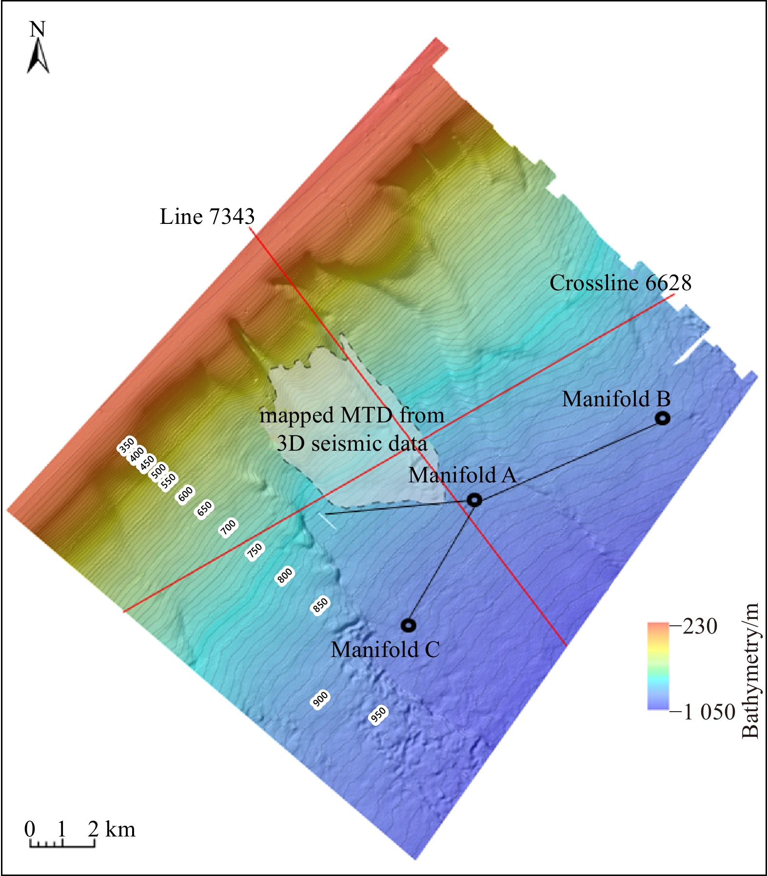
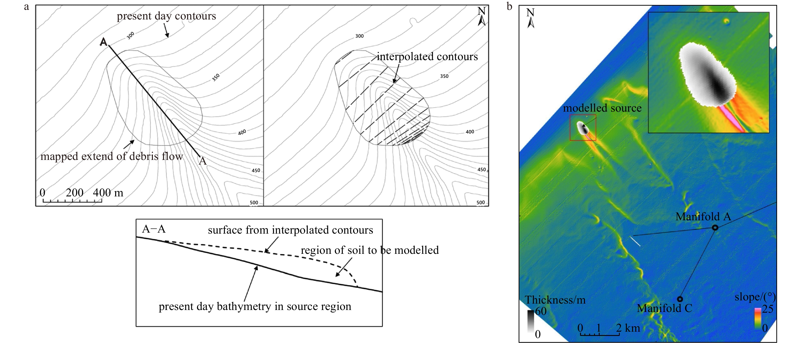
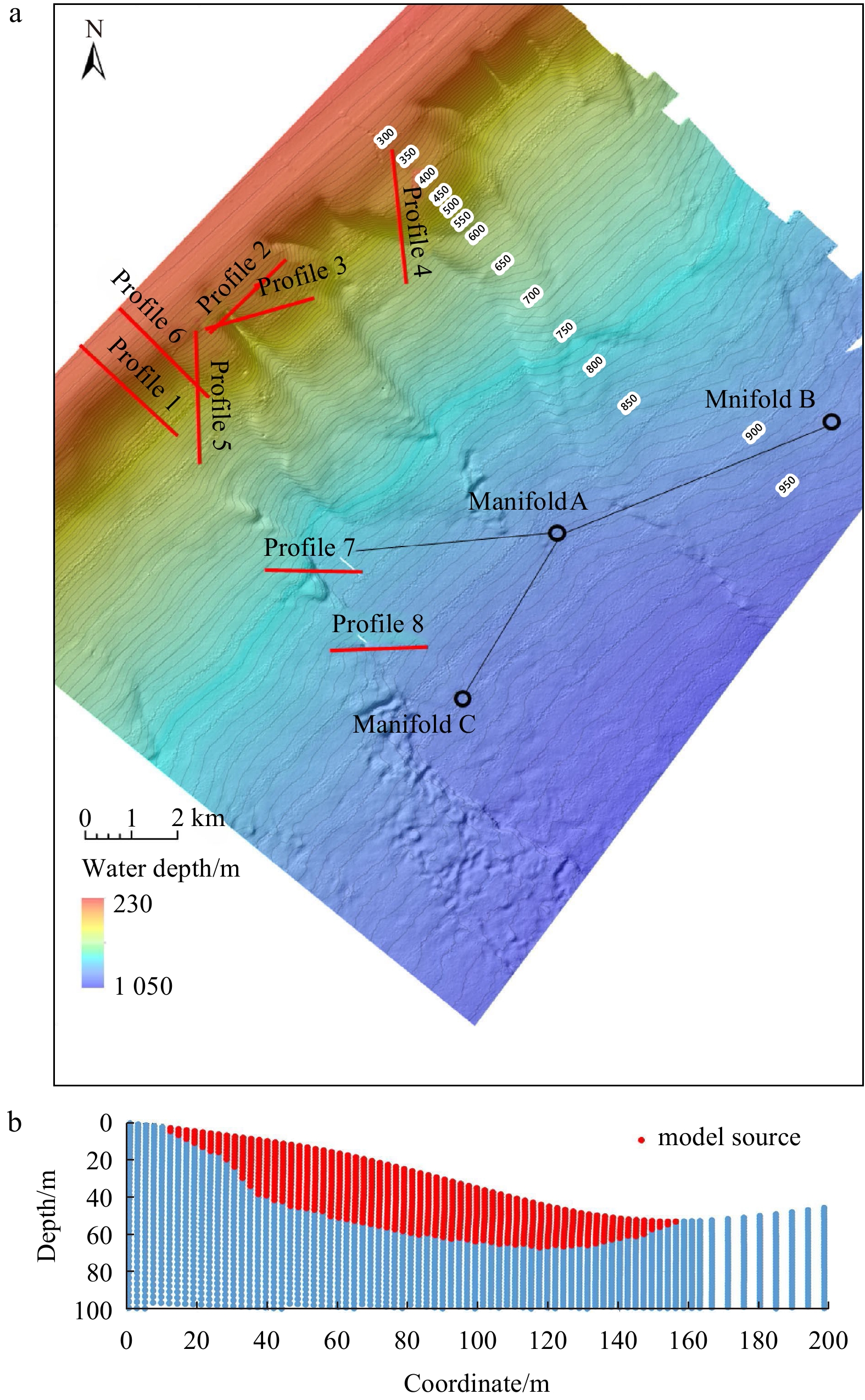
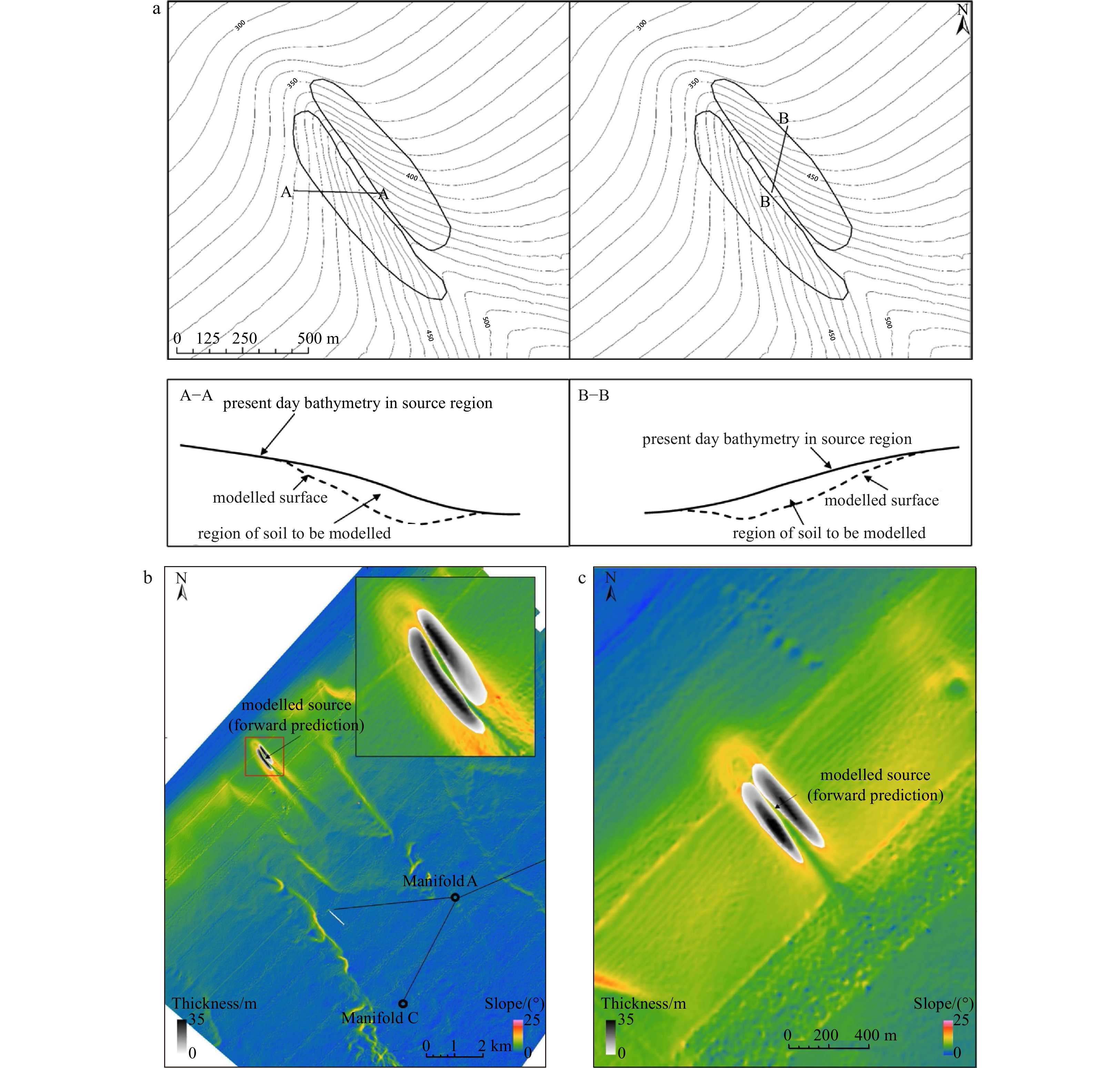
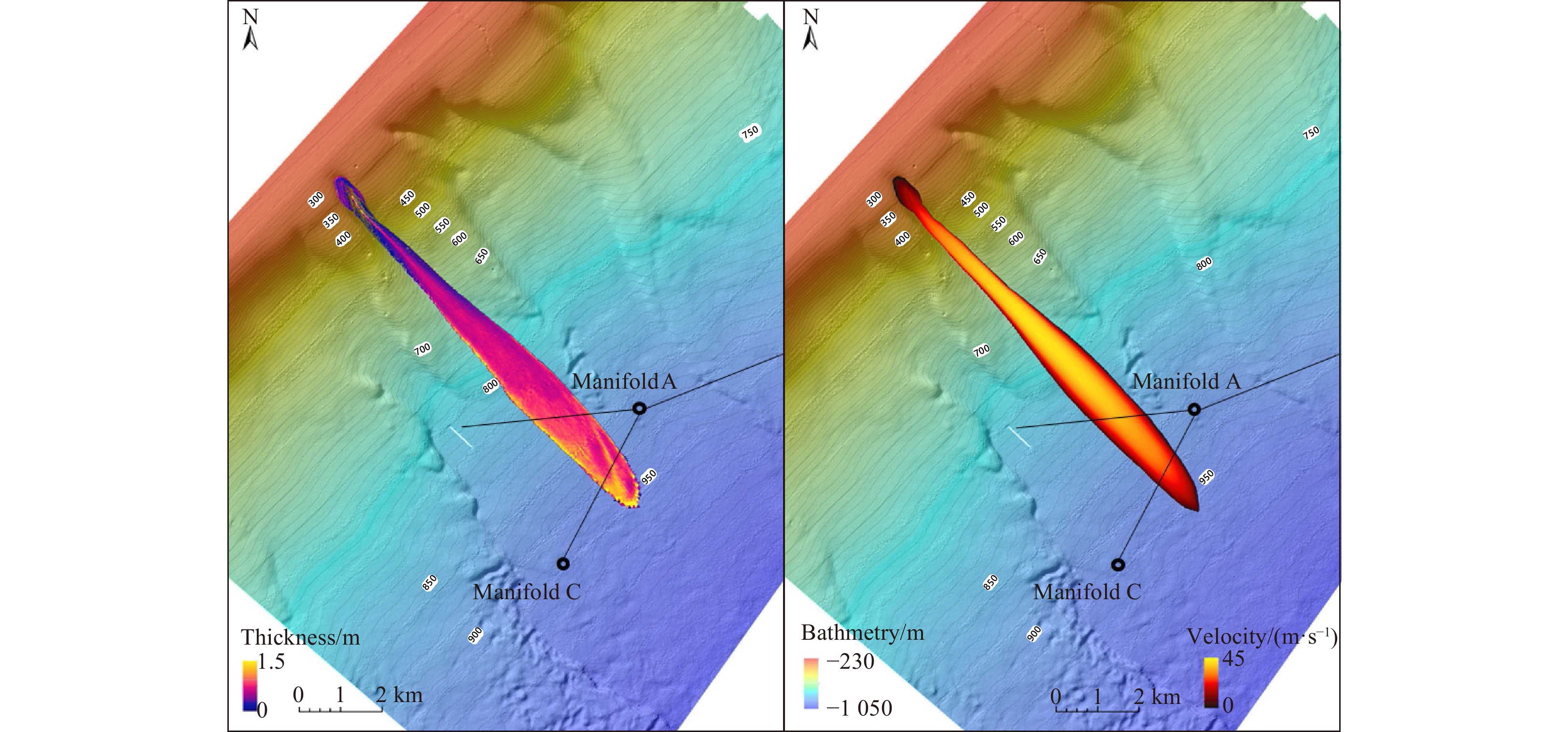
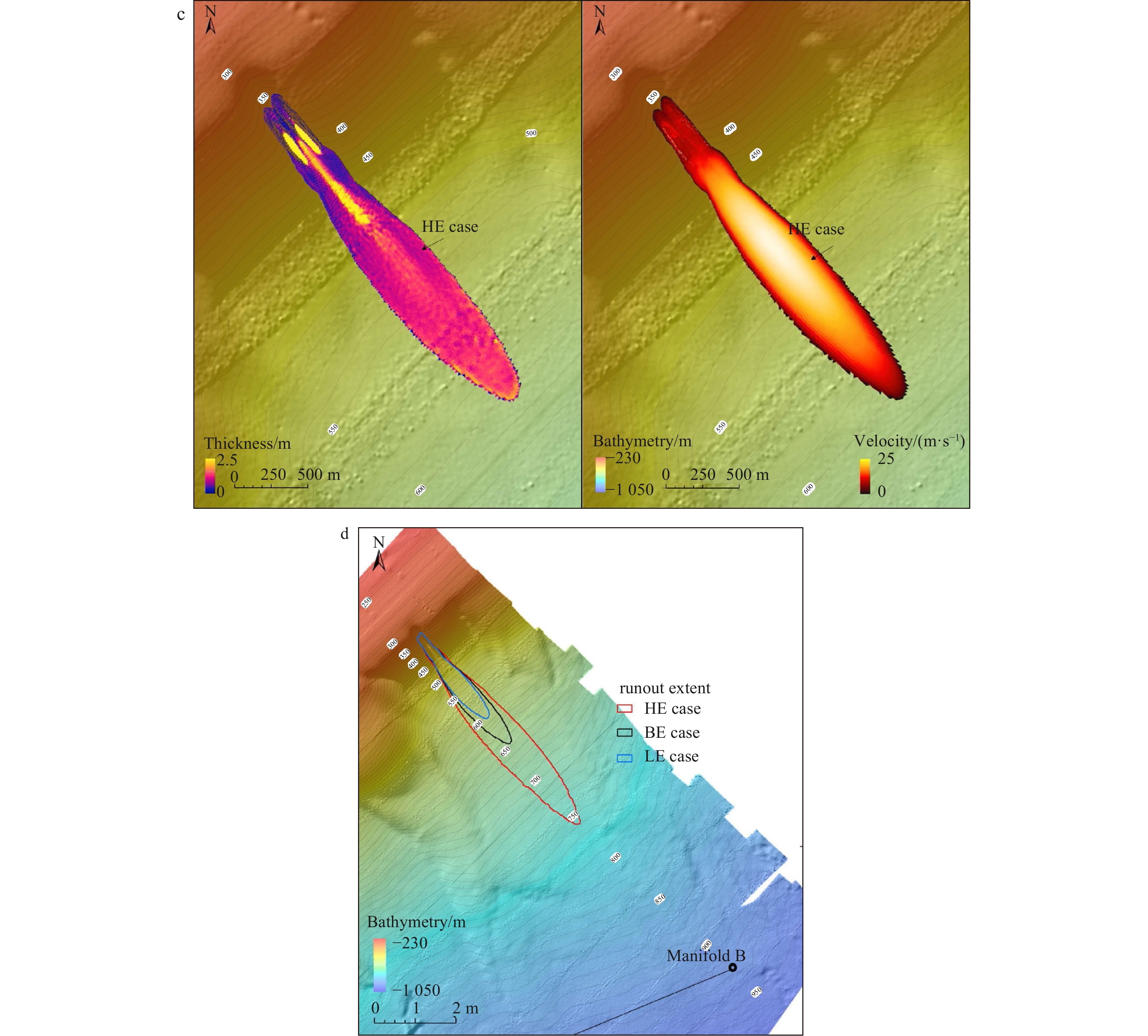
The ever-increasing deepwater oil and gas development in the Qiongdongnan Basin, South China Sea has initiated the need to evaluate submarine debris-flow hazard risks to seafloor infrastructures. This paper presents a case study on evaluating the debris-flow hazard risks to the planned pipeline systems in this region. We used a numerical model to perform simulations to support this quantitative evaluation. First, one relict failure interpreted across the development site was simulated. The back-analysis modeling was used to validate the applicability of the rheological parameters. Then, this model was applied to forecast the runout behaviors of future debris flows originating from the unstable upslope regions considered to be the most critical to the pipeline systems surrounding the Manifolds A and B. The model results showed that the potential debris-flow hazard risks rely on the location of structures and the selection of rheological parameters. For the Manifold B and connected pipeline systems, because of their remote distances away from unstable canyon flanks, the potential debris flows impose few risks. However, the pipeline systems around the Manifold A are exposed to significant hazard risks from future debris flows with selected rheological parameters. These results are beneficial for the design of a more resilient pipeline route in consideration of future debris-flow hazard risks.
The ever-increasing deepwater oil and gas development in the Qiongdongnan Basin, South China Sea has initiated the need to evaluate submarine debris-flow hazard risks to seafloor infrastructures. This paper presents a case study on evaluating the debris-flow hazard risks to the planned pipeline systems in this region. We used a numerical model to perform simulations to support this quantitative evaluation. First, one relict failure interpreted across the development site was simulated. The back-analysis modeling was used to validate the applicability of the rheological parameters. Then, this model was applied to forecast the runout behaviors of future debris flows originating from the unstable upslope regions considered to be the most critical to the pipeline systems surrounding the Manifolds A and B. The model results showed that the potential debris-flow hazard risks rely on the location of structures and the selection of rheological parameters. For the Manifold B and connected pipeline systems, because of their remote distances away from unstable canyon flanks, the potential debris flows impose few risks. However, the pipeline systems around the Manifold A are exposed to significant hazard risks from future debris flows with selected rheological parameters. These results are beneficial for the design of a more resilient pipeline route in consideration of future debris-flow hazard risks.


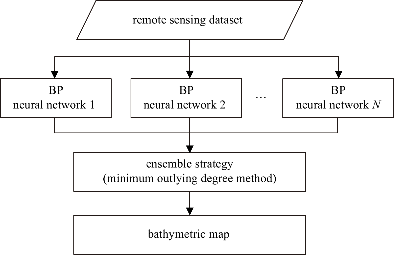
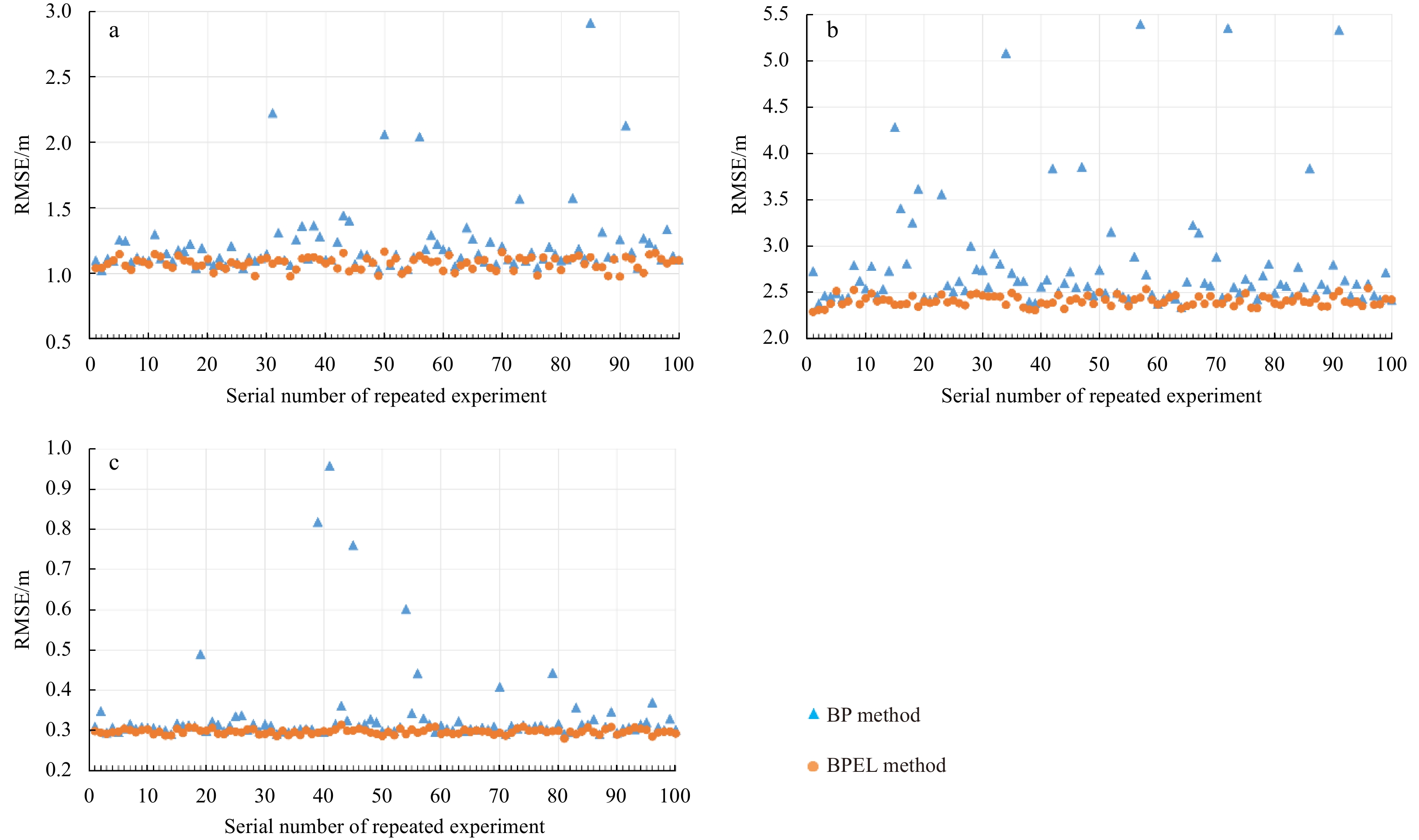
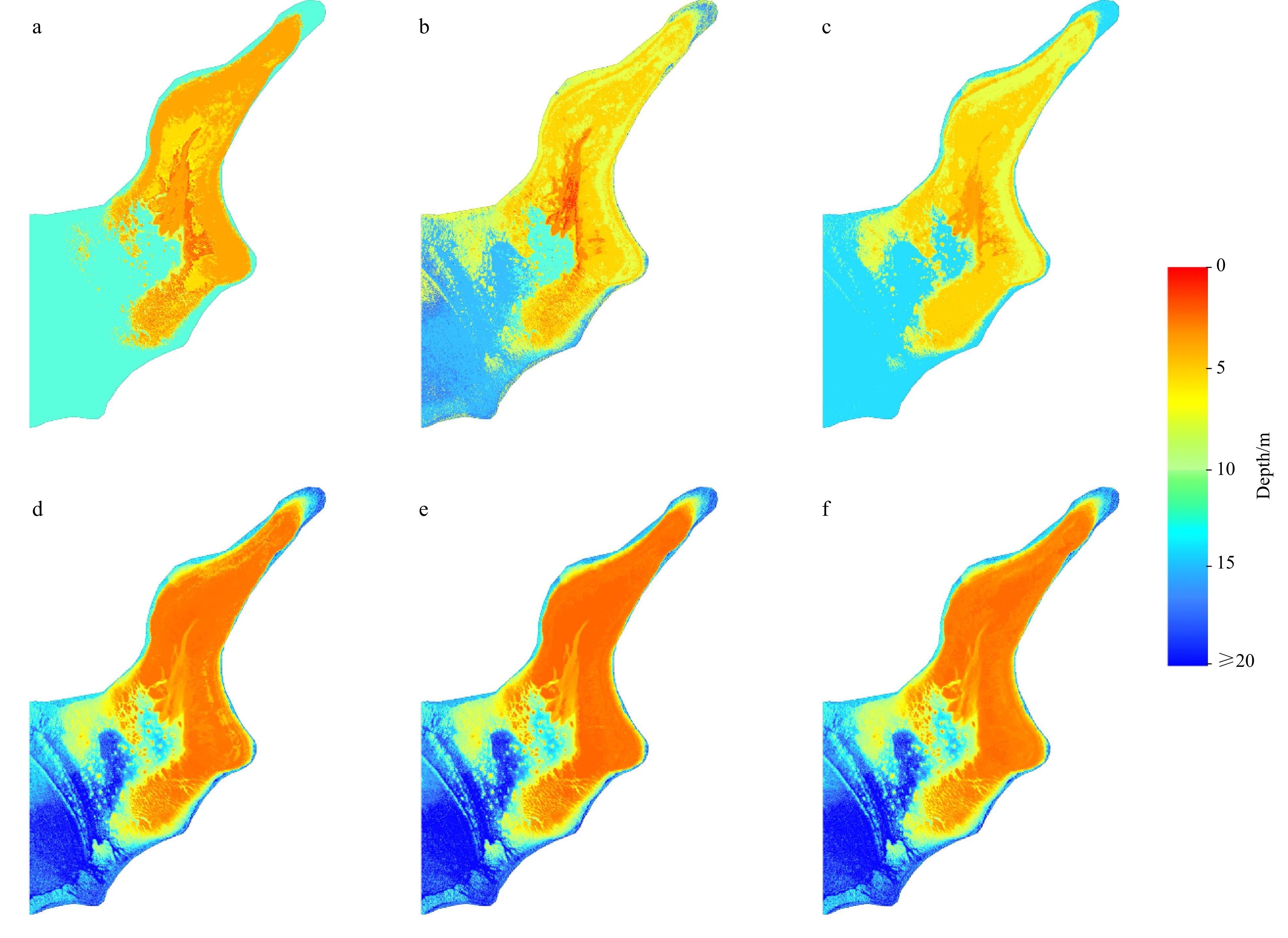
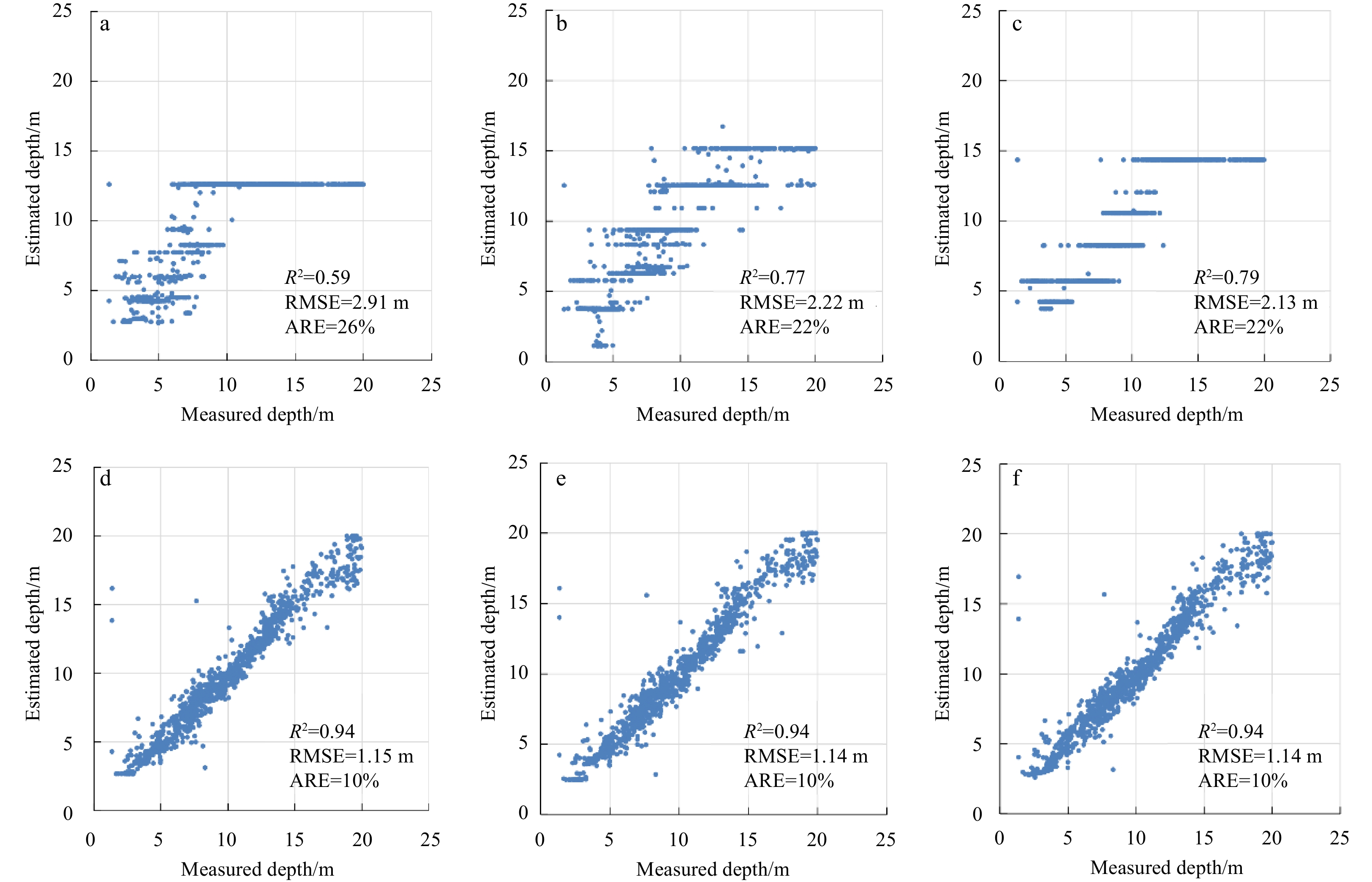
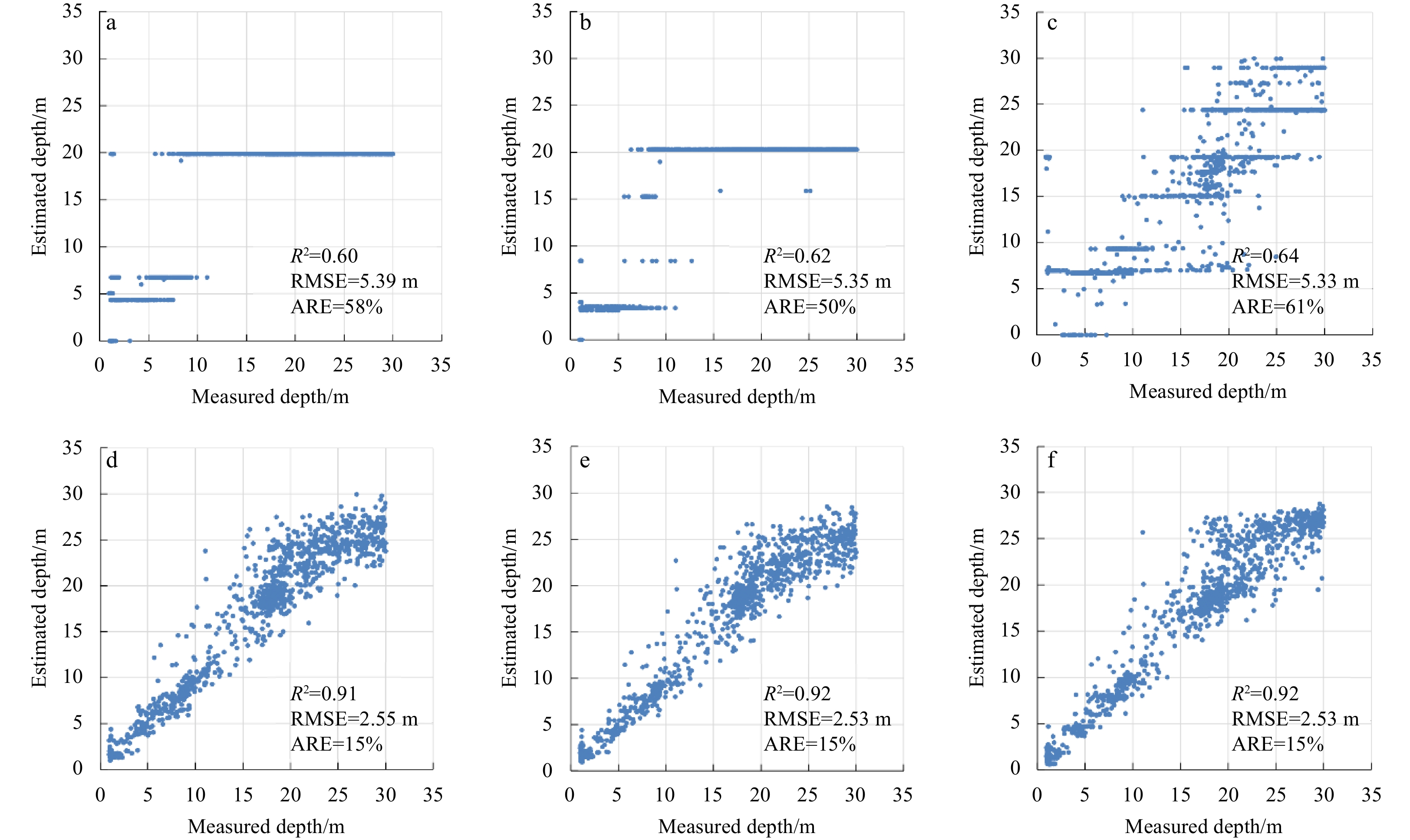
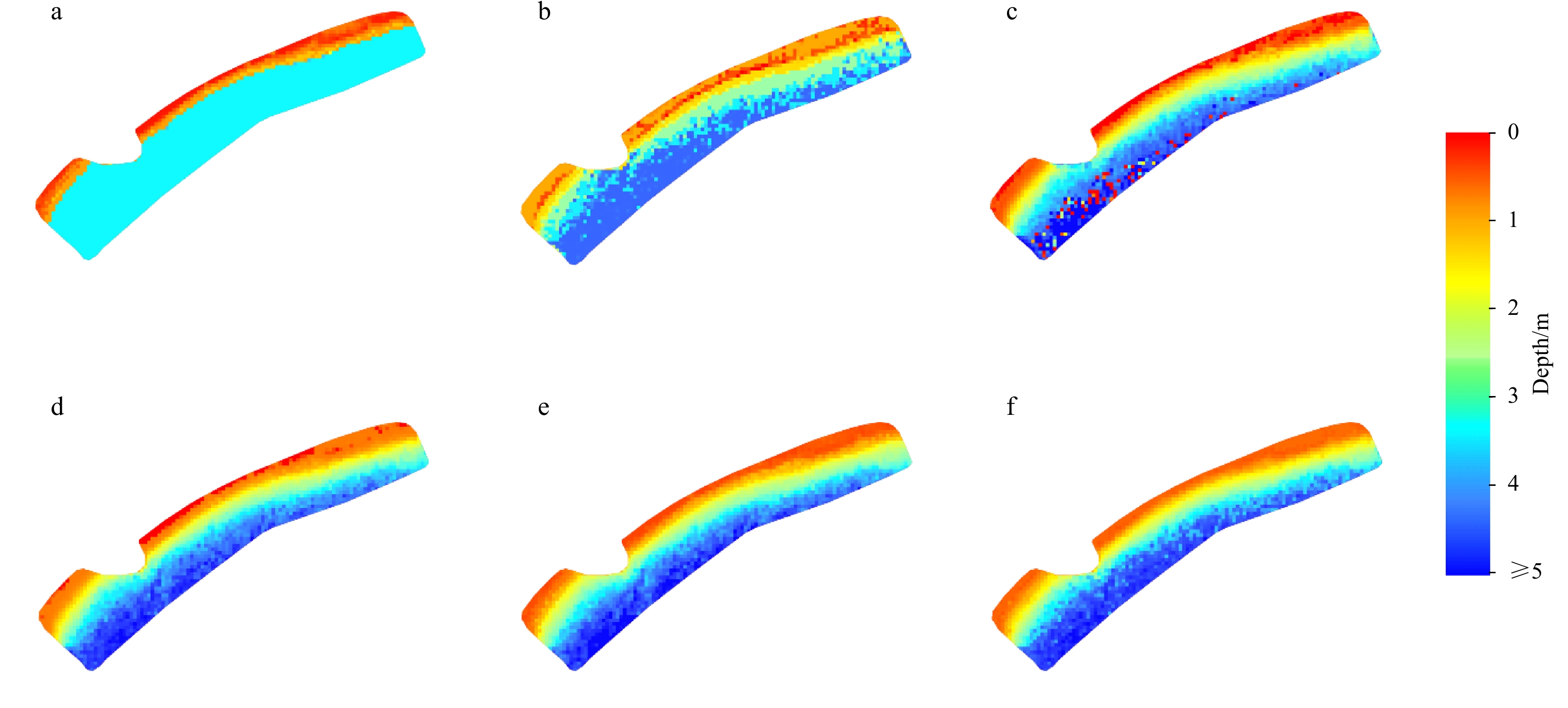
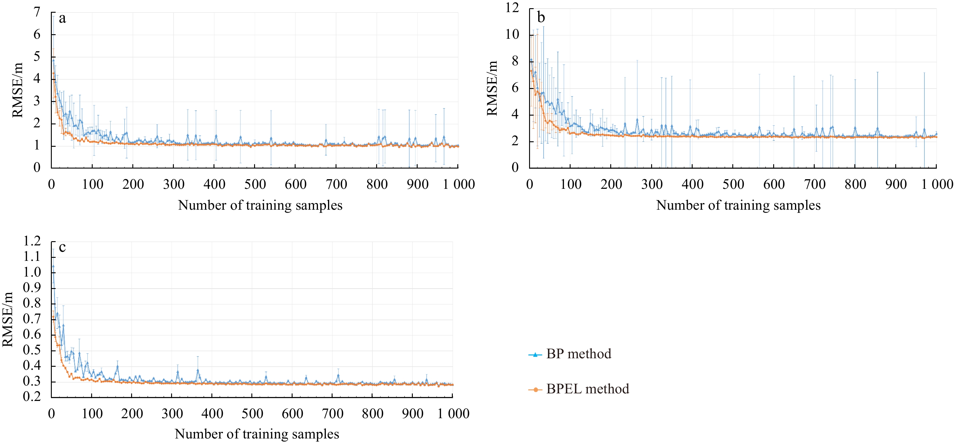
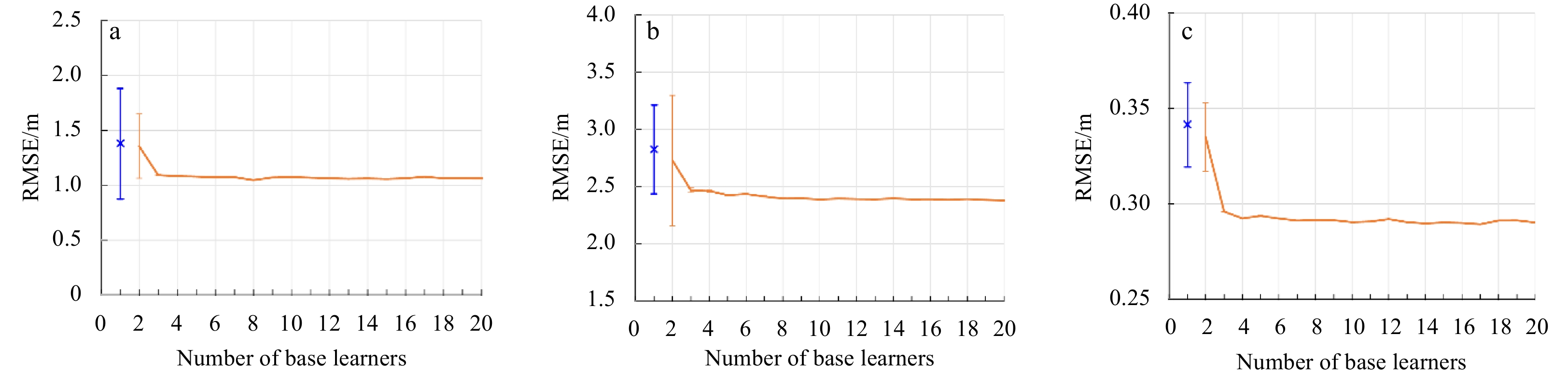
2023, 42(5): 154-165.
doi: 10.1007/s13131-022-2065-6
Abstract:
The back propagation (BP) neural network method is widely used in bathymetry based on multispectral satellite imagery. However, the classical BP neural network method faces a potential problem because it easily falls into a local minimum, leading to model training failure. This study confirmed that the local minimum problem of the BP neural network method exists in the bathymetry field and cannot be ignored. Furthermore, to solve the local minimum problem of the BP neural network method, a bathymetry method based on a BP neural network and ensemble learning (BPEL) is proposed. First, the remote sensing imagery and training sample were used as input datasets, and the BP method was used as the base learner to produce multiple water depth inversion results. Then, a new ensemble strategy, namely the minimum outlying degree method, was proposed and used to integrate the water depth inversion results. Finally, an ensemble bathymetric map was acquired. Anda Reef, northeastern Jiuzhang Atoll, and Pingtan coastal zone were selected as test cases to validate the proposed method. Compared with the BP neural network method, the root-mean-square error and the average relative error of the BPEL method can reduce by 0.65–2.84 m and 16%–46% in the three test cases at most. The results showed that the proposed BPEL method could solve the local minimum problem of the BP neural network method and obtain highly robust and accurate bathymetric maps.
The back propagation (BP) neural network method is widely used in bathymetry based on multispectral satellite imagery. However, the classical BP neural network method faces a potential problem because it easily falls into a local minimum, leading to model training failure. This study confirmed that the local minimum problem of the BP neural network method exists in the bathymetry field and cannot be ignored. Furthermore, to solve the local minimum problem of the BP neural network method, a bathymetry method based on a BP neural network and ensemble learning (BPEL) is proposed. First, the remote sensing imagery and training sample were used as input datasets, and the BP method was used as the base learner to produce multiple water depth inversion results. Then, a new ensemble strategy, namely the minimum outlying degree method, was proposed and used to integrate the water depth inversion results. Finally, an ensemble bathymetric map was acquired. Anda Reef, northeastern Jiuzhang Atoll, and Pingtan coastal zone were selected as test cases to validate the proposed method. Compared with the BP neural network method, the root-mean-square error and the average relative error of the BPEL method can reduce by 0.65–2.84 m and 16%–46% in the three test cases at most. The results showed that the proposed BPEL method could solve the local minimum problem of the BP neural network method and obtain highly robust and accurate bathymetric maps.


2023, 42(5): 166-178.
doi: 10.1007/s13131-022-2075-4
Abstract:
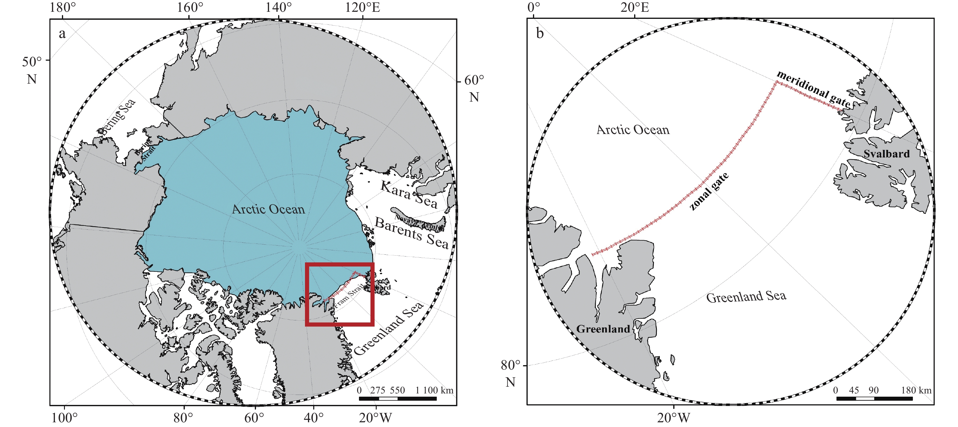
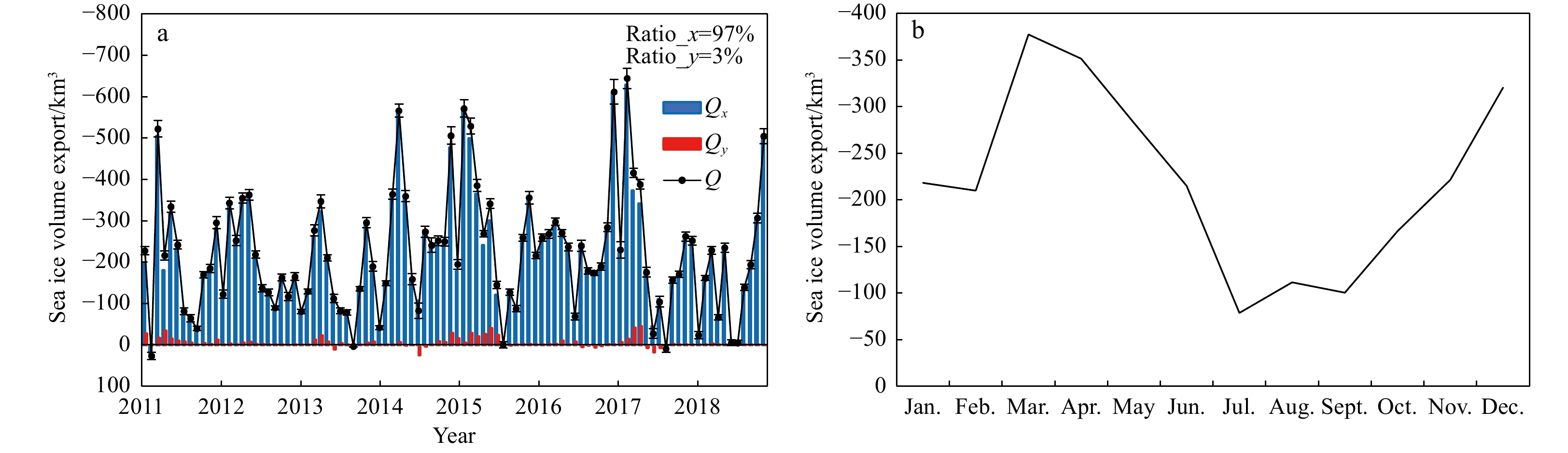
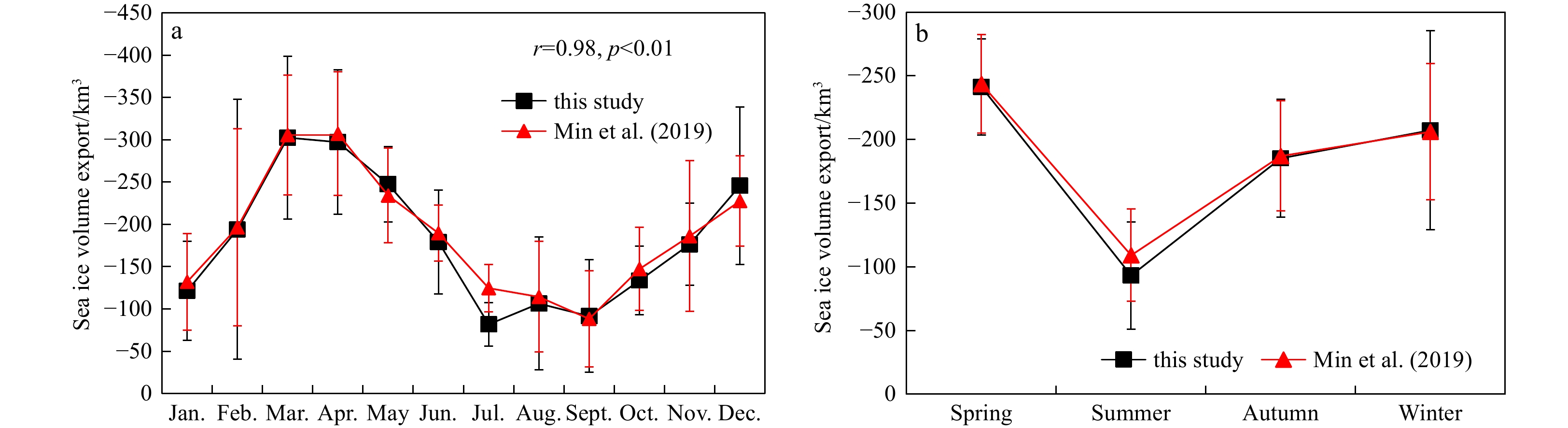
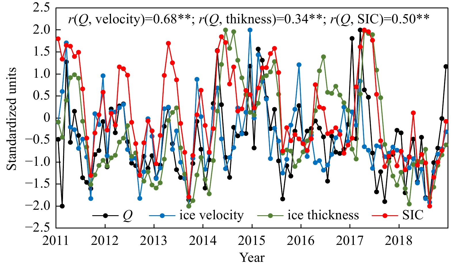
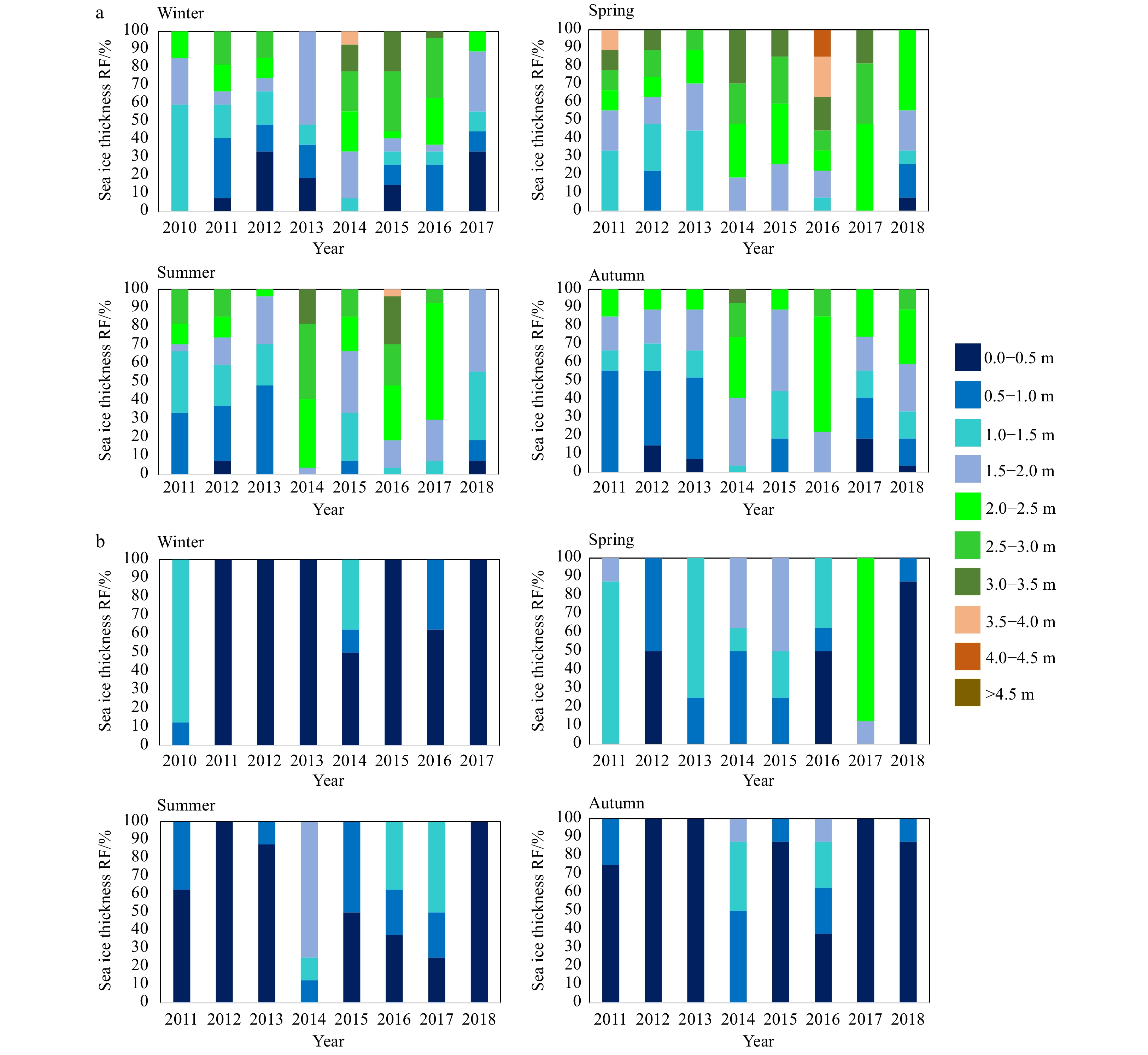
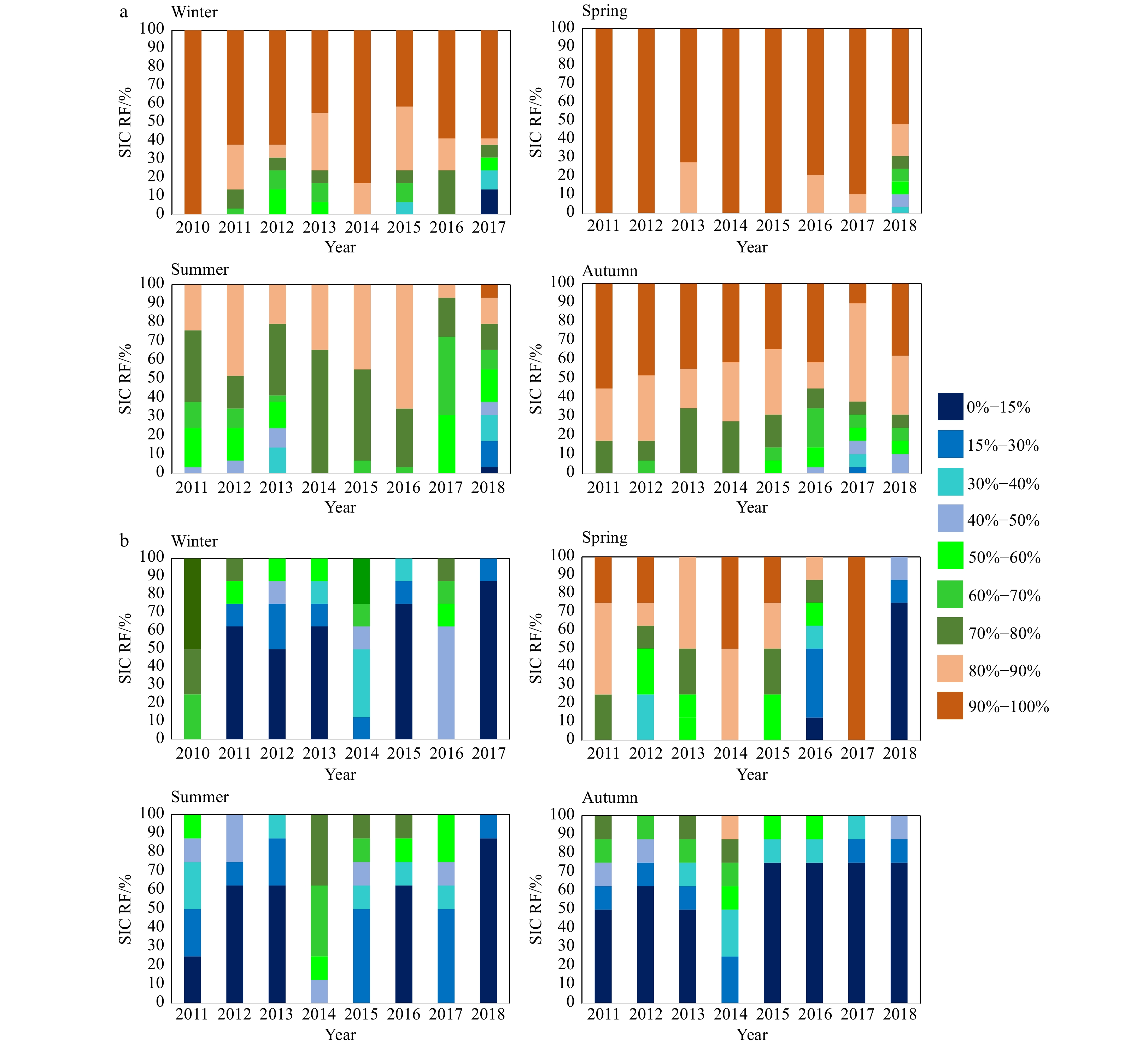
Arctic sea ice export is important for the redistribution of freshwater and sea ice mass. Here, we use the sea ice thickness, sea ice velocity, and sea ice concentration (SIC) to estimate the exported sea ice volume through the Fram Strait from 2011 to 2018. We further analyse the contributions of the sea ice thickness, velocity and concentration to sea ice volume export. Then, the relationships between atmospheric circulation indices (Arctic Oscillation (AO), North Atlantic Oscillation (NAO), and Arctic Dipole (AD)) and the sea ice volume export are discussed. Finally, we analyse the impact of wind-driven oceanic circulation indices (Ekman transport (ET)) on the sea ice volume export. The sea ice volume export rapidly increases in winter and decreases in spring. The exported sea ice volume in winter is likely to exceed that in spring in the future. Among sea ice thickness, velocity and SIC, the greatest contribution to sea ice export comes from the ice velocity. The exported sea ice volume through the zonal gate of the Fram Strait (which contributes 97% to the total sea ice volume export of the Fram Strait) is much higher than that through the meridional gate (3%) because the sea ice flowing out of the zonal gate has the characteristics of a high thickness (mainly thicker than 1 m), a high velocity (mainly faster than 0.06 m/s) and a high concentration (mainly higher than 80%). The AD and ET explain 53.86% and 38.37% of the variation in sea ice volume export, respectively.
Arctic sea ice export is important for the redistribution of freshwater and sea ice mass. Here, we use the sea ice thickness, sea ice velocity, and sea ice concentration (SIC) to estimate the exported sea ice volume through the Fram Strait from 2011 to 2018. We further analyse the contributions of the sea ice thickness, velocity and concentration to sea ice volume export. Then, the relationships between atmospheric circulation indices (Arctic Oscillation (AO), North Atlantic Oscillation (NAO), and Arctic Dipole (AD)) and the sea ice volume export are discussed. Finally, we analyse the impact of wind-driven oceanic circulation indices (Ekman transport (ET)) on the sea ice volume export. The sea ice volume export rapidly increases in winter and decreases in spring. The exported sea ice volume in winter is likely to exceed that in spring in the future. Among sea ice thickness, velocity and SIC, the greatest contribution to sea ice export comes from the ice velocity. The exported sea ice volume through the zonal gate of the Fram Strait (which contributes 97% to the total sea ice volume export of the Fram Strait) is much higher than that through the meridional gate (3%) because the sea ice flowing out of the zonal gate has the characteristics of a high thickness (mainly thicker than 1 m), a high velocity (mainly faster than 0.06 m/s) and a high concentration (mainly higher than 80%). The AD and ET explain 53.86% and 38.37% of the variation in sea ice volume export, respectively.


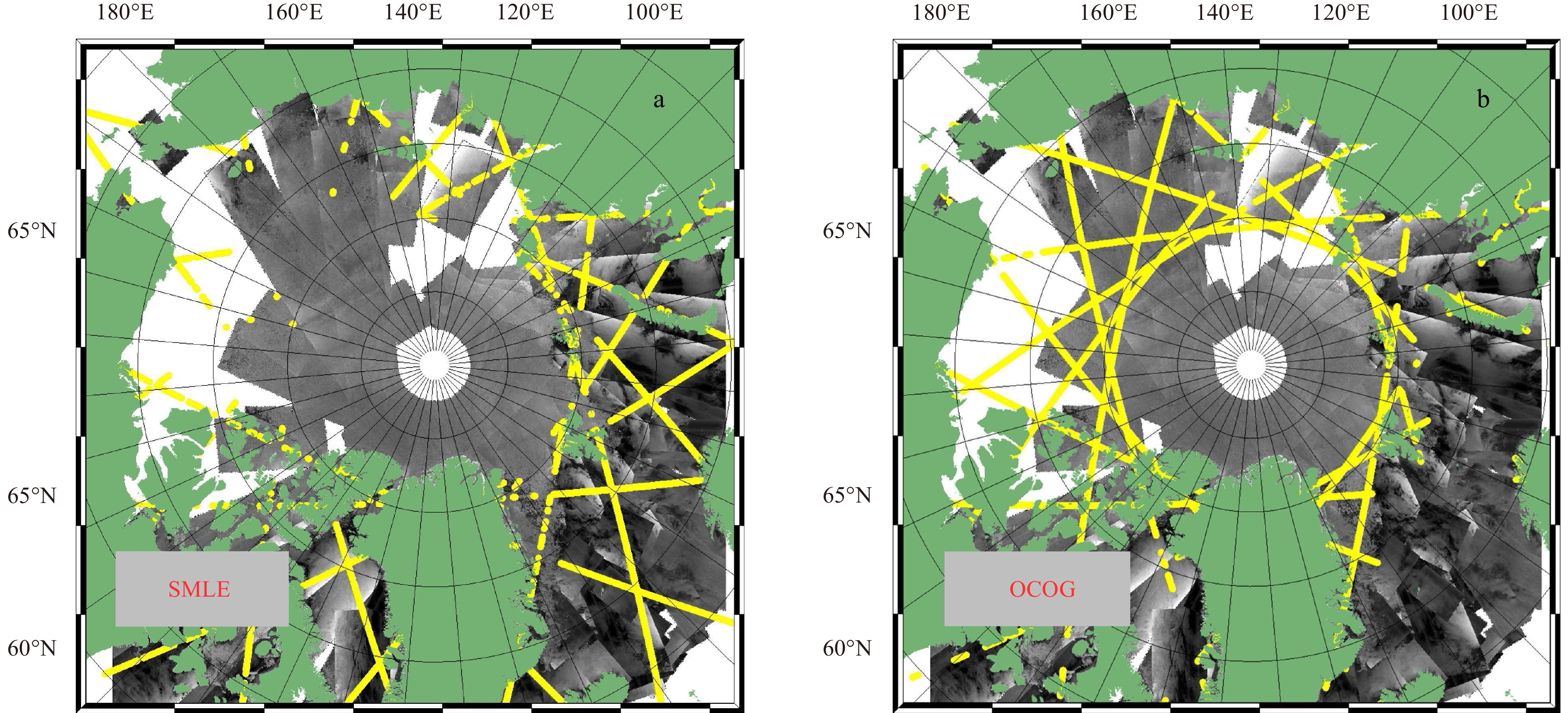
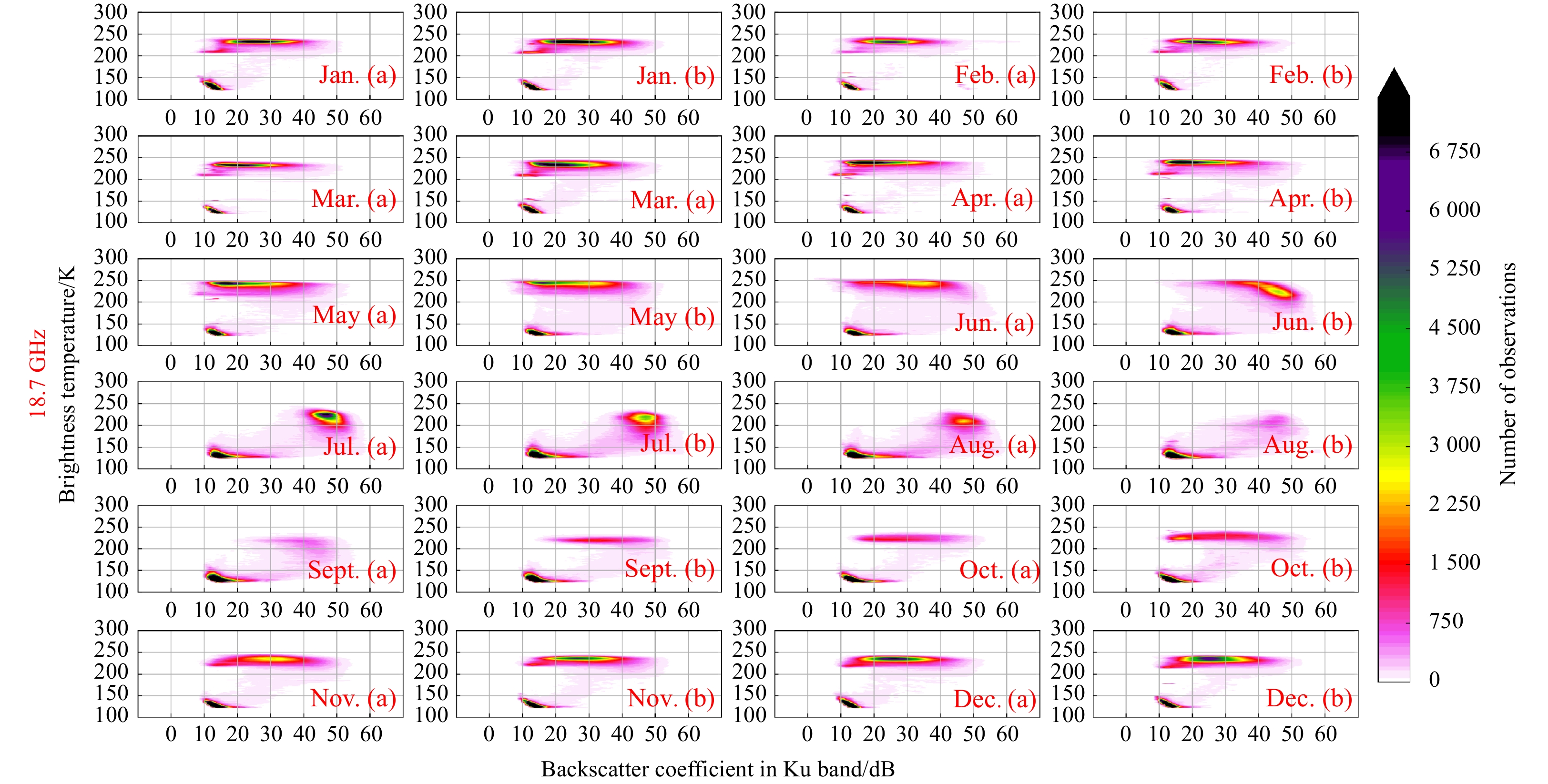
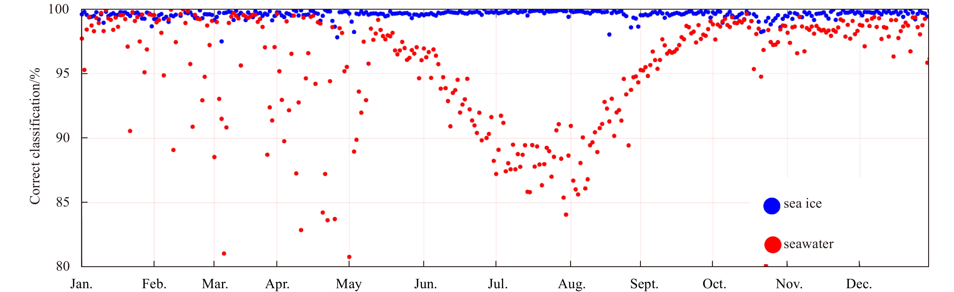
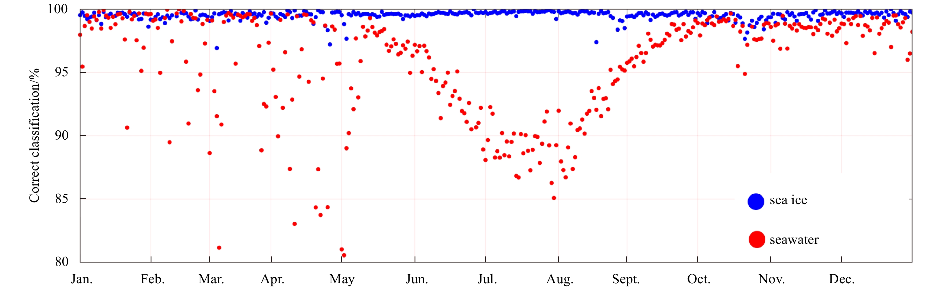
2023, 42(5): 179-191.
doi: 10.1007/s13131-022-2067-4
Abstract:
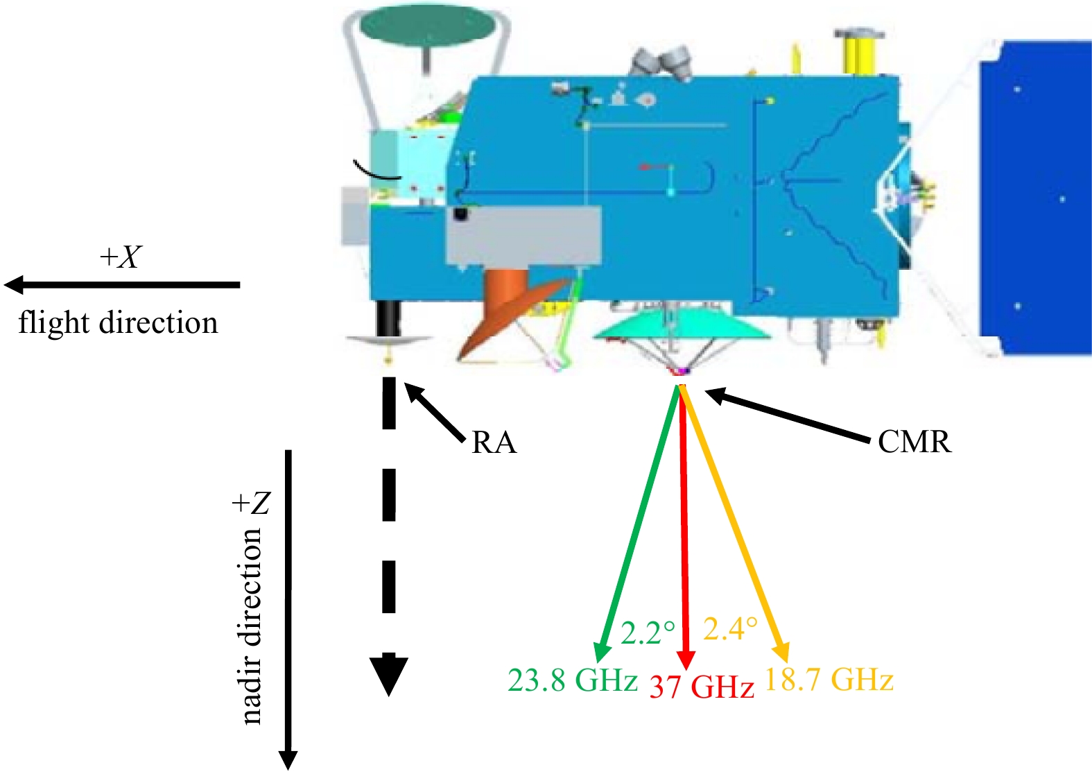
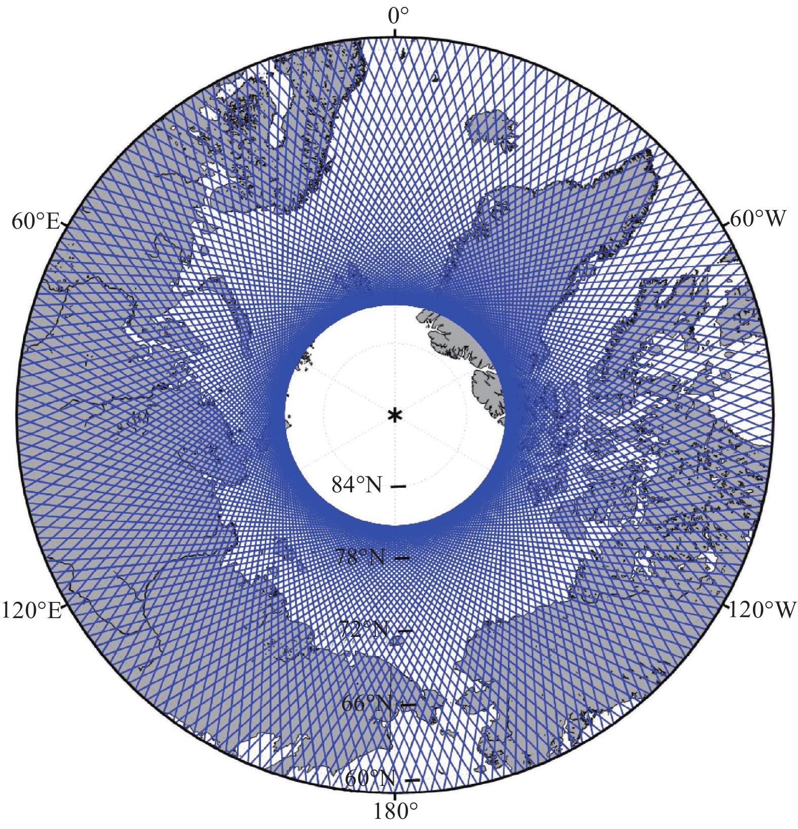
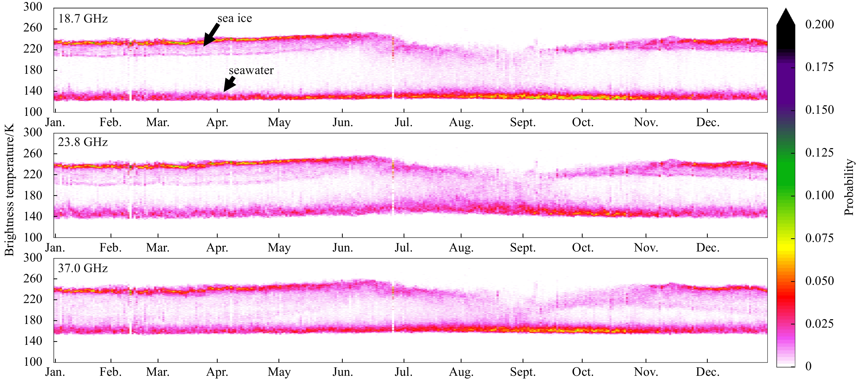
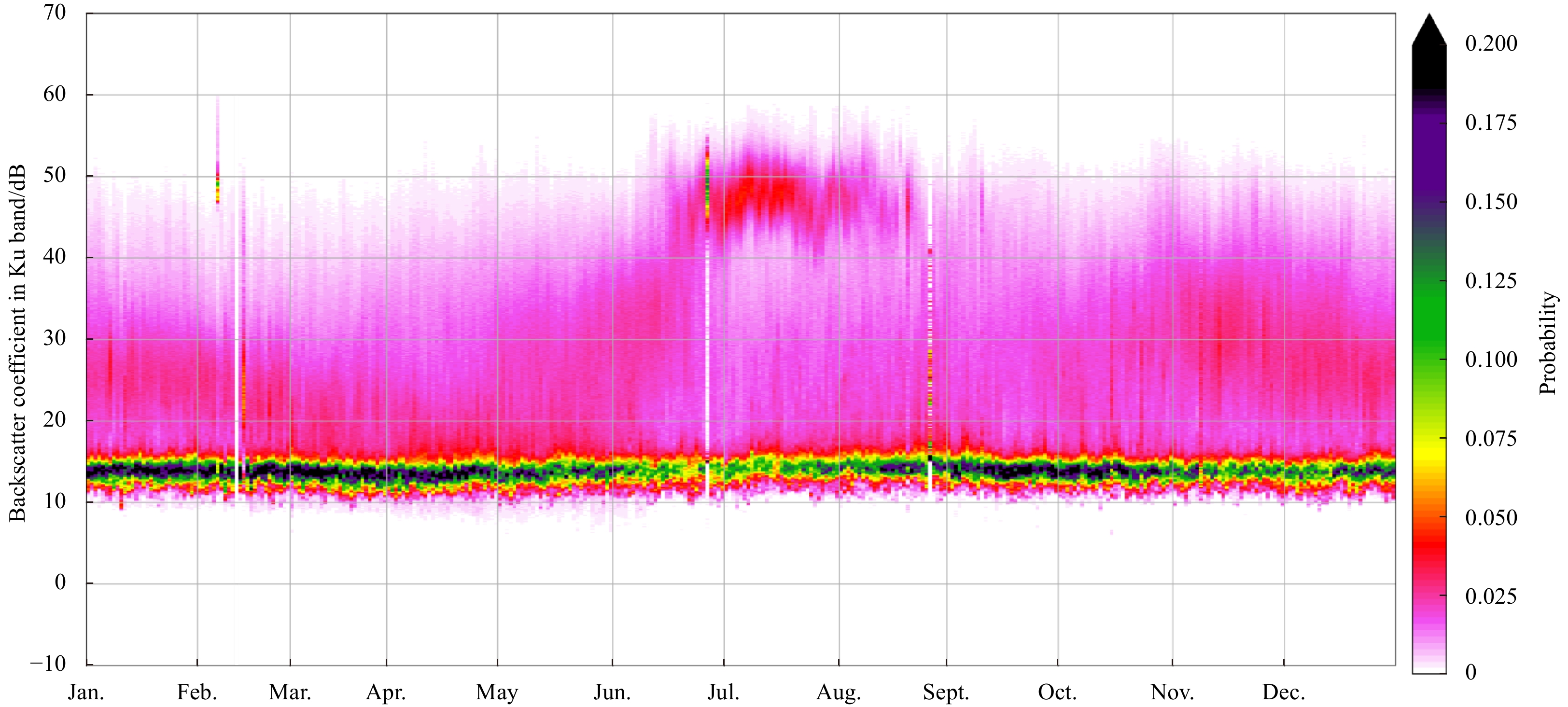
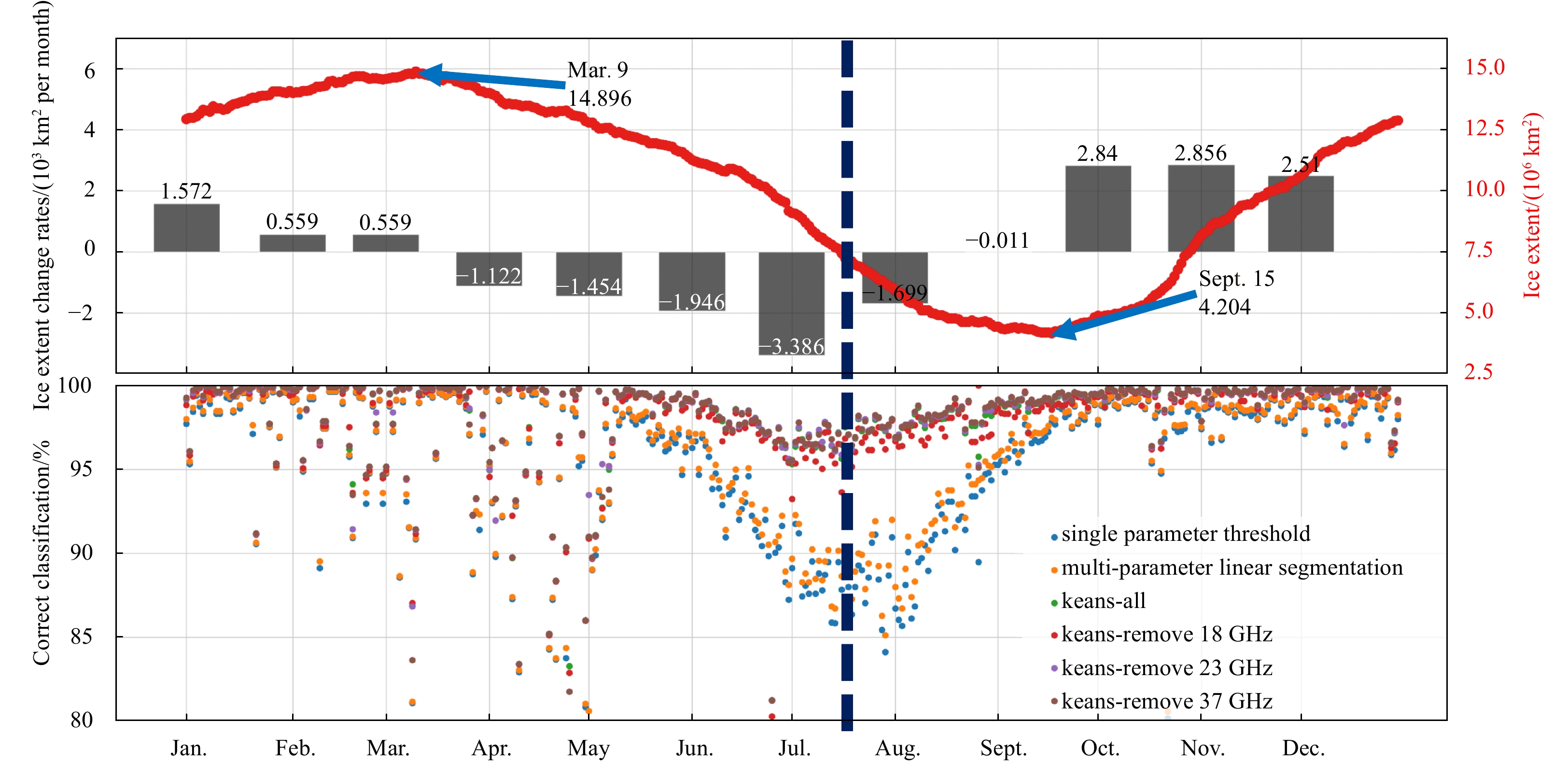
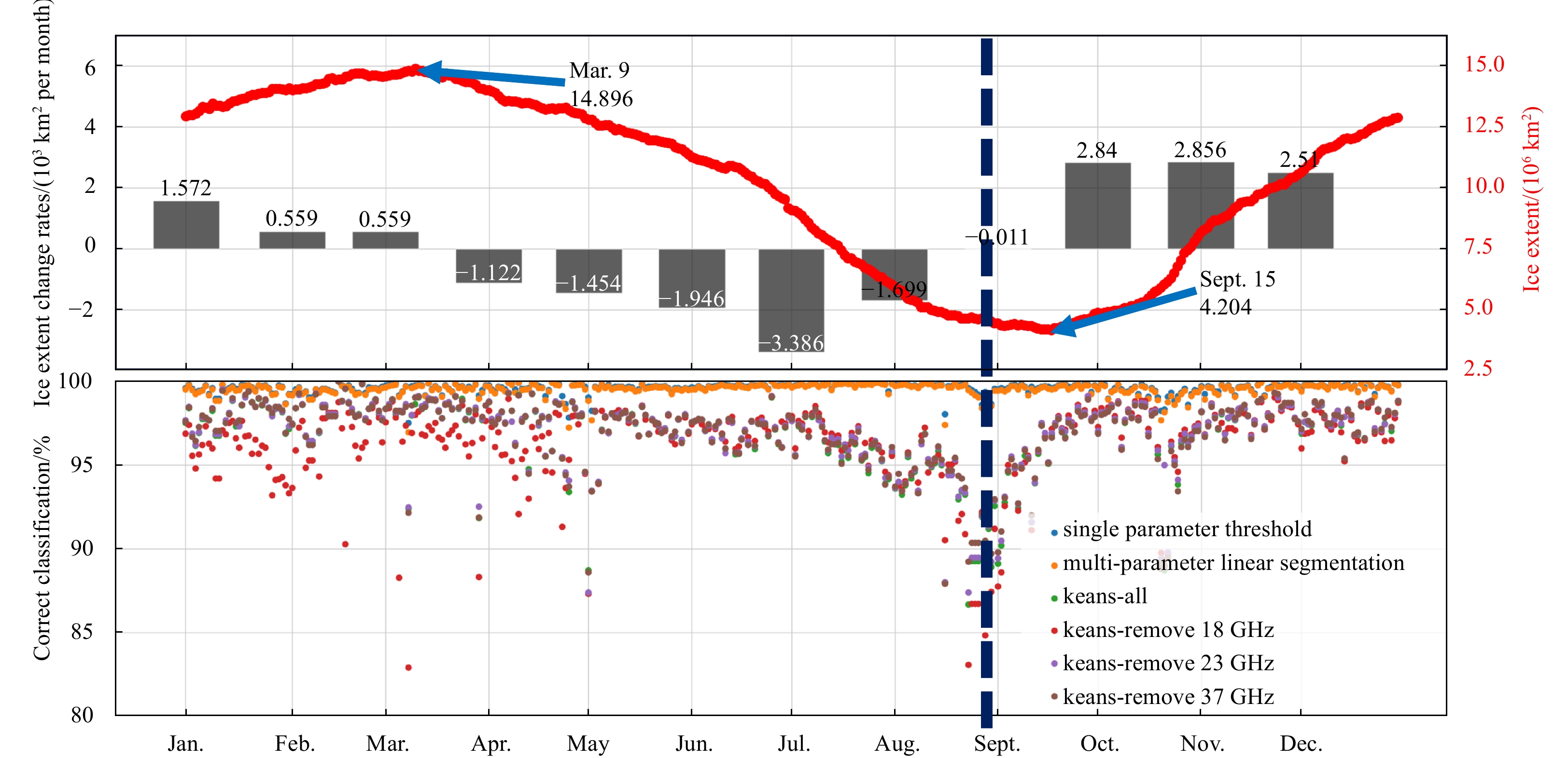
Several Chinese marine satellites have been launched in recent years. Monitoring sea ice and the ocean in the Arctic is of great importance for climate research. Sea ice in the Arctic has changed rapidly during the past few decades with respect to the extent and thickness. In this study, we applied combined passive and active microwave data from the Chinese HaiYang-2B (HY-2B) satellite to classify ice and sea water in the Arctic. We use data from a radar altimeter (RA) and a calibration microwave radiometer (CMR) to discriminate between ice and water by applying several approaches (1) the single parameter threshold criteria, (2) the multi-parameters linear segmentations and (3) the K-means clustering. The results yielded by these methods were in good agreement (classification accuracy >95%) with the Satellite Application Facility on Ocean and Sea Ice products between November and April. For other months (May–October), however, the agreement was less good (lowest classification accuracy approximate 85% in summer). A hybrid approach combined with graphical ice edges detection and microwave radar waveform analysis is therefore developed. A visual comparison with SAR images suggested the hybrid approach results greatly improved the ice and water discrimination in summer. This study demonstrated that multi-sensors (RA and CMR) configurations from HY satellites can offer comparable polar earth observation to the European Space Agency and NOAA satellite products.
Several Chinese marine satellites have been launched in recent years. Monitoring sea ice and the ocean in the Arctic is of great importance for climate research. Sea ice in the Arctic has changed rapidly during the past few decades with respect to the extent and thickness. In this study, we applied combined passive and active microwave data from the Chinese HaiYang-2B (HY-2B) satellite to classify ice and sea water in the Arctic. We use data from a radar altimeter (RA) and a calibration microwave radiometer (CMR) to discriminate between ice and water by applying several approaches (1) the single parameter threshold criteria, (2) the multi-parameters linear segmentations and (3) the K-means clustering. The results yielded by these methods were in good agreement (classification accuracy >95%) with the Satellite Application Facility on Ocean and Sea Ice products between November and April. For other months (May–October), however, the agreement was less good (lowest classification accuracy approximate 85% in summer). A hybrid approach combined with graphical ice edges detection and microwave radar waveform analysis is therefore developed. A visual comparison with SAR images suggested the hybrid approach results greatly improved the ice and water discrimination in summer. This study demonstrated that multi-sensors (RA and CMR) configurations from HY satellites can offer comparable polar earth observation to the European Space Agency and NOAA satellite products.