
2023 Vol. 42, No. 6
Display Method:
2023, 42(6): 1-15.
doi: 10.1007/s13131-022-2130-1
Abstract:
How coral reefs with high productivity and biodiversity can flourish in oligotrophic tropical oceans has inspired substantial research on coral reef ecosystems. Increasing evidence shows that similar to water in an oasis in the desert, there are stable nutrient supplies to coral reefs in oligotrophic oceans. Here, with emphasis on the fluxes of organic matter, we summarize at the ecosystem level (1) the multiple input pathways of external nutrients, (2) the storage of nutrients in reef organisms, (3) the efficient retaining and recycling of dissolved and particulate organic matter within coral reef ecosystems, (4) the distinctly high phytoplankton productivity and biomass inside and near oceanic coral reefs, and (5) the export of reef-related organic carbon to adjacent open oceans. These properties enable coral reefs to function as ecological “pumps” for gathering nutrients across ecosystems and space, retaining and recycling nutrients within the ecosystem, supporting high phytoplankton productivity, and exporting organic carbon to adjacent open oceans. Particularly, the high phytoplankton productivity and biomass make waters around coral reefs potential hotspots of carbon export to ocean depths via the biological pump. We demonstrate that organic carbon influx is vital for coral reef ecosystems’ carbon budget and carbon export. The concept of the coral reef ecological pump provides a framework to improve the understanding of the functioning of the coral reef ecosystem and its responses to disturbance. Prospects of the coral reef ecological pump in coral reef studies are discussed in changing oceans driven by human activities and global change in the Anthropocene.
How coral reefs with high productivity and biodiversity can flourish in oligotrophic tropical oceans has inspired substantial research on coral reef ecosystems. Increasing evidence shows that similar to water in an oasis in the desert, there are stable nutrient supplies to coral reefs in oligotrophic oceans. Here, with emphasis on the fluxes of organic matter, we summarize at the ecosystem level (1) the multiple input pathways of external nutrients, (2) the storage of nutrients in reef organisms, (3) the efficient retaining and recycling of dissolved and particulate organic matter within coral reef ecosystems, (4) the distinctly high phytoplankton productivity and biomass inside and near oceanic coral reefs, and (5) the export of reef-related organic carbon to adjacent open oceans. These properties enable coral reefs to function as ecological “pumps” for gathering nutrients across ecosystems and space, retaining and recycling nutrients within the ecosystem, supporting high phytoplankton productivity, and exporting organic carbon to adjacent open oceans. Particularly, the high phytoplankton productivity and biomass make waters around coral reefs potential hotspots of carbon export to ocean depths via the biological pump. We demonstrate that organic carbon influx is vital for coral reef ecosystems’ carbon budget and carbon export. The concept of the coral reef ecological pump provides a framework to improve the understanding of the functioning of the coral reef ecosystem and its responses to disturbance. Prospects of the coral reef ecological pump in coral reef studies are discussed in changing oceans driven by human activities and global change in the Anthropocene.


2023, 42(6): 16-23.
doi: 10.1007/s13131-022-2145-7
Abstract:
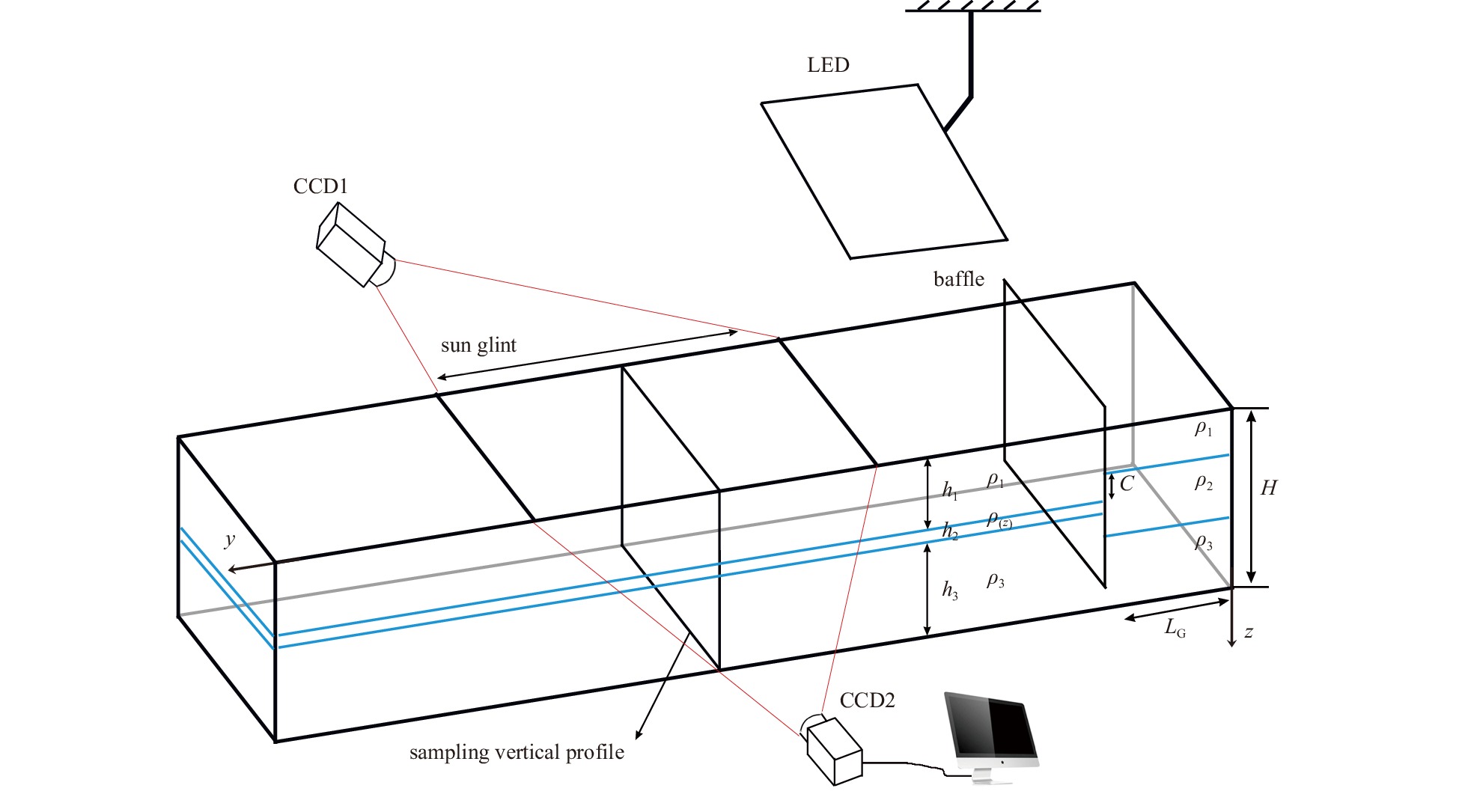
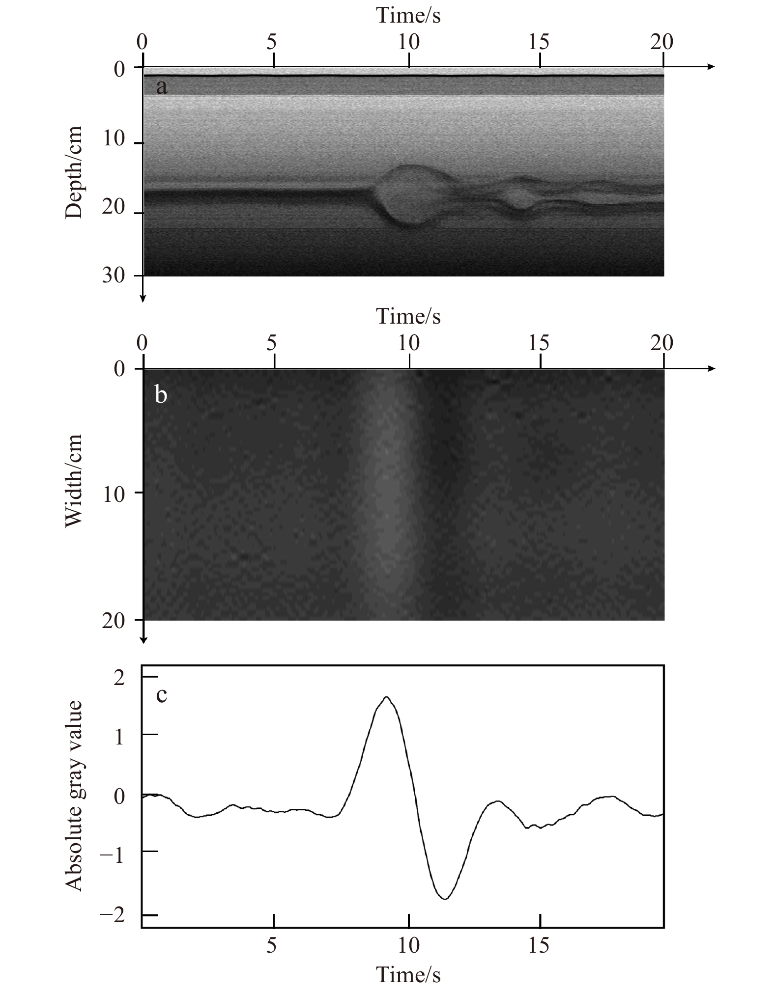
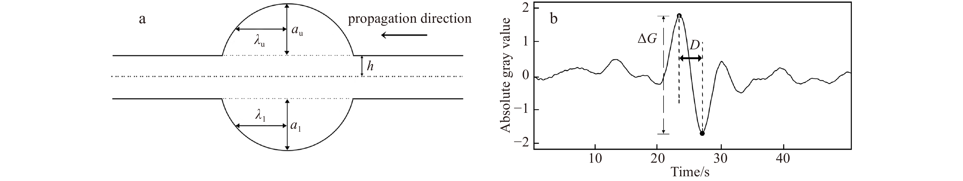
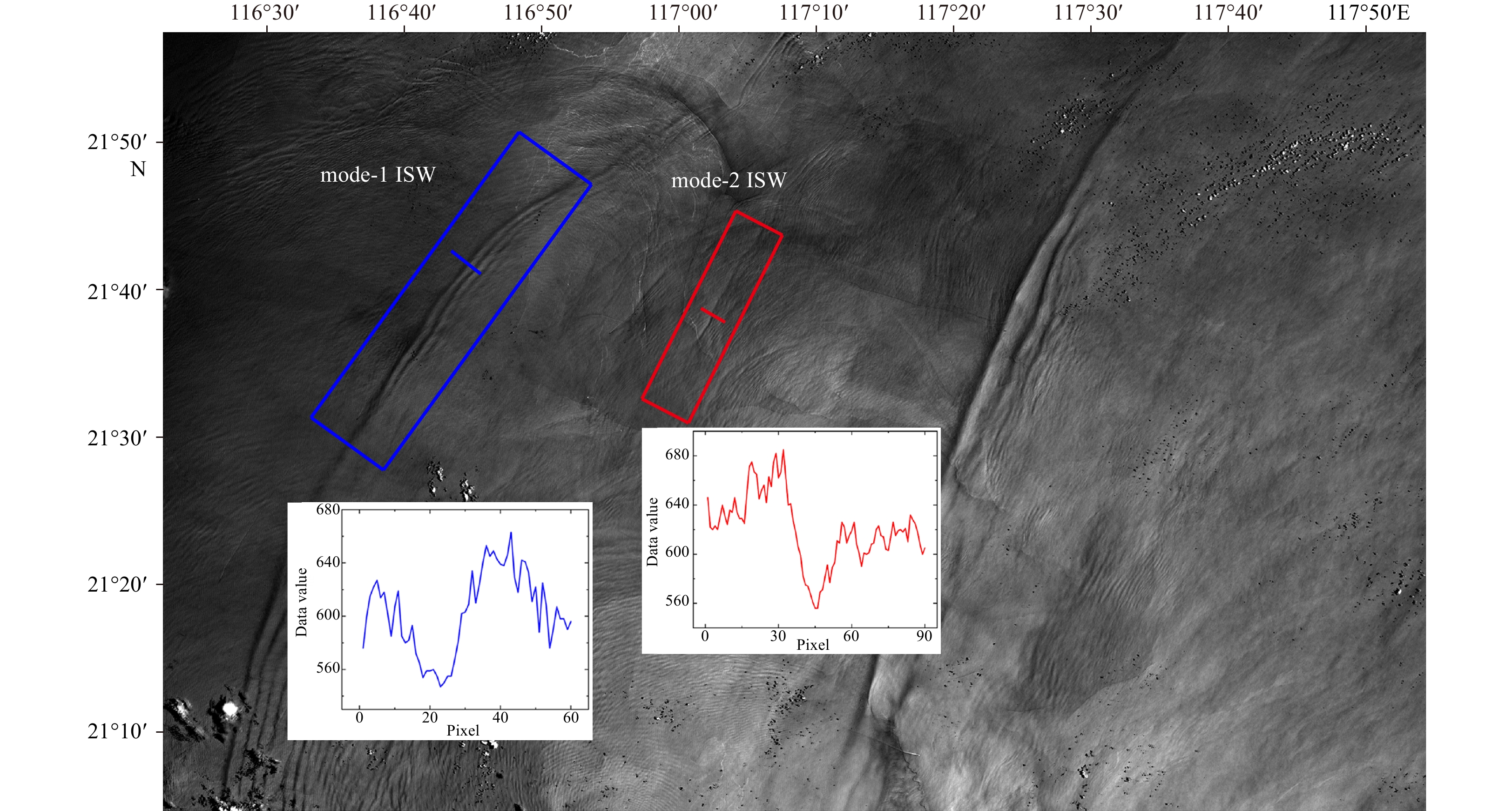
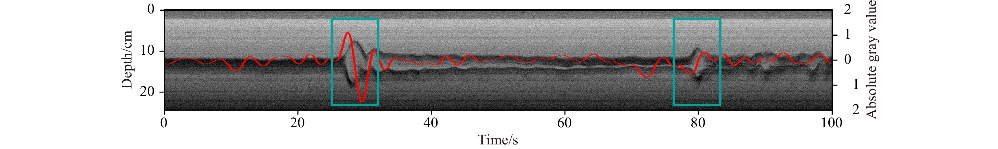
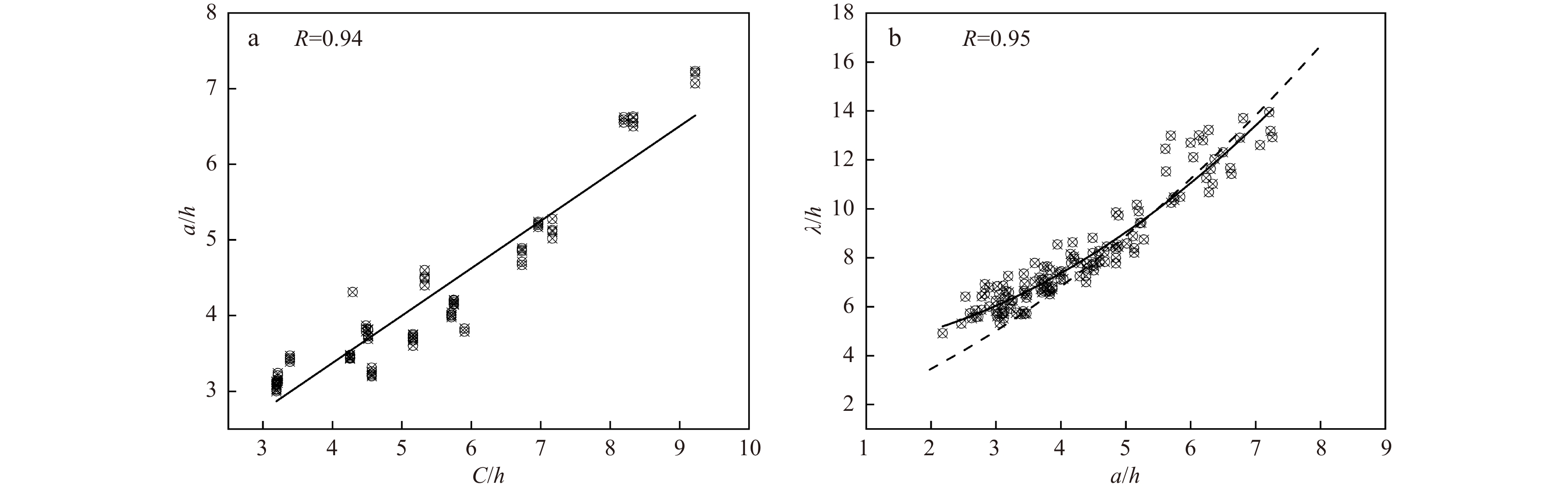
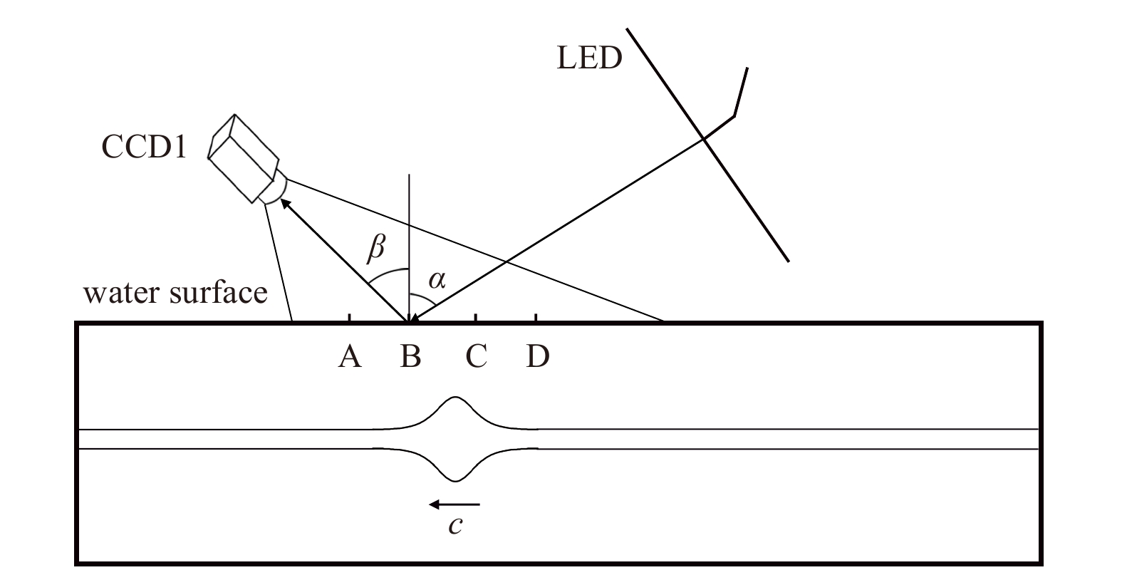
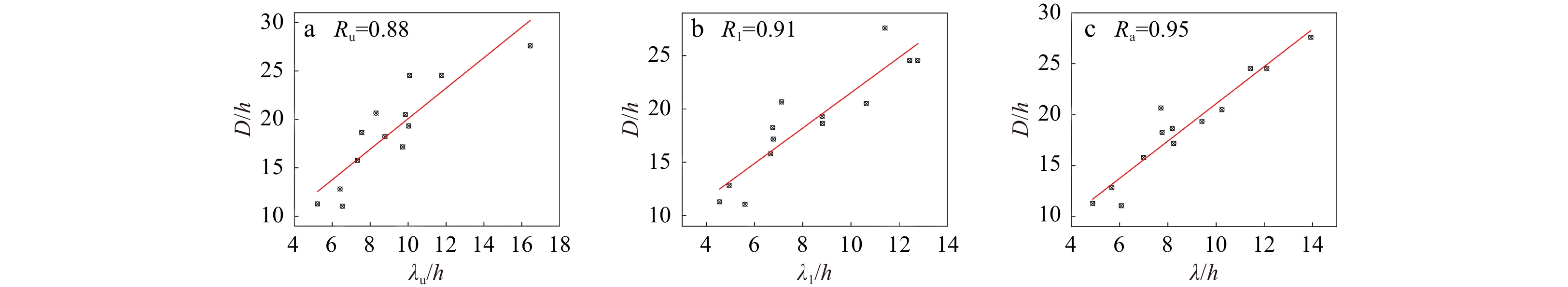
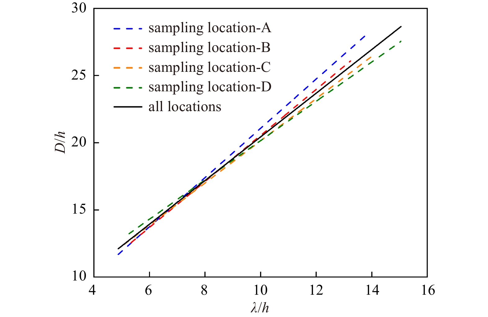
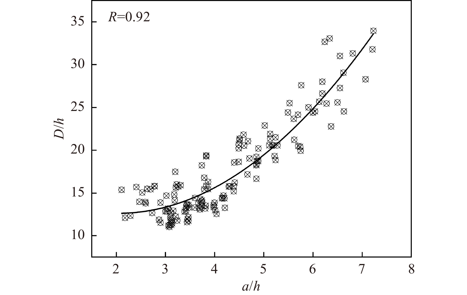
A series of experiments are designed to propose a new method to study the characteristics of convex mode-2 internal solitary waves (ISWs) in optical remote sensing images using a laboratory-based optical remote sensing simulation platform. The corresponding wave parameters of large-amplitude convex mode-2 ISWs under smooth surfaces are investigated along with the optical remote sensing characteristic parameters. The mode-2 ISWs in the experimentally obtained optical remote sensing image are produced by their overall modulation effect on the water surface, and the extreme points of the gray value of the profile curve of bright-dark stripes appear at the same location as the real optical remote sensing image. The present data extend to a larger range than previous studies, and for the characteristics of large amplitude convex mode-2 ISWs, the experimental results show a second-order dependence of wavelength on amplitude. There is a close relationship between optical remote sensing characteristic parameters and wave parameters of mode-2 ISWs, in which there is a positive linear relationship between the bright-dark spacing and wavelength and a nonlinear relationship with the amplitude, especially when the amplitude is very large, there is a significant increase in bright-dark spacing.
A series of experiments are designed to propose a new method to study the characteristics of convex mode-2 internal solitary waves (ISWs) in optical remote sensing images using a laboratory-based optical remote sensing simulation platform. The corresponding wave parameters of large-amplitude convex mode-2 ISWs under smooth surfaces are investigated along with the optical remote sensing characteristic parameters. The mode-2 ISWs in the experimentally obtained optical remote sensing image are produced by their overall modulation effect on the water surface, and the extreme points of the gray value of the profile curve of bright-dark stripes appear at the same location as the real optical remote sensing image. The present data extend to a larger range than previous studies, and for the characteristics of large amplitude convex mode-2 ISWs, the experimental results show a second-order dependence of wavelength on amplitude. There is a close relationship between optical remote sensing characteristic parameters and wave parameters of mode-2 ISWs, in which there is a positive linear relationship between the bright-dark spacing and wavelength and a nonlinear relationship with the amplitude, especially when the amplitude is very large, there is a significant increase in bright-dark spacing.
2023, 42(6): 24-32.
doi: 10.1007/s13131-022-2102-5
Abstract:
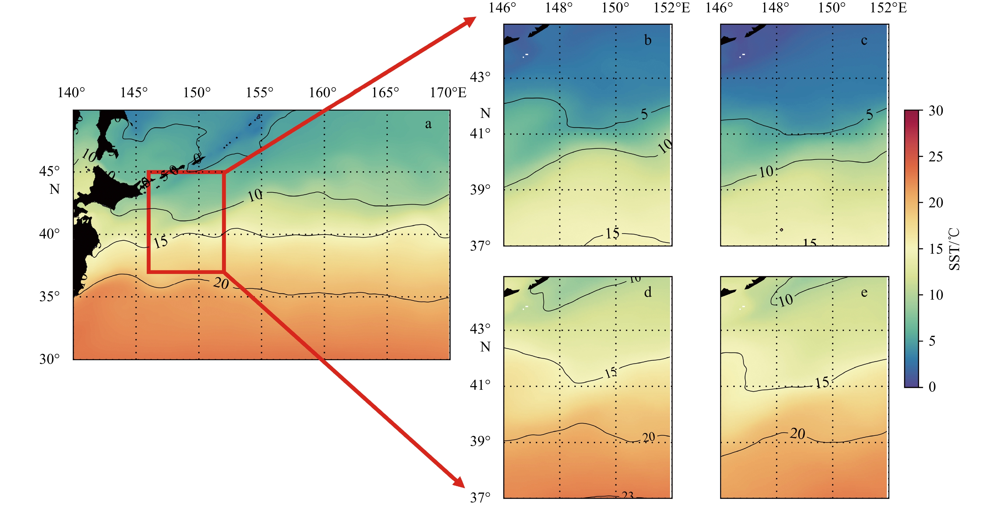
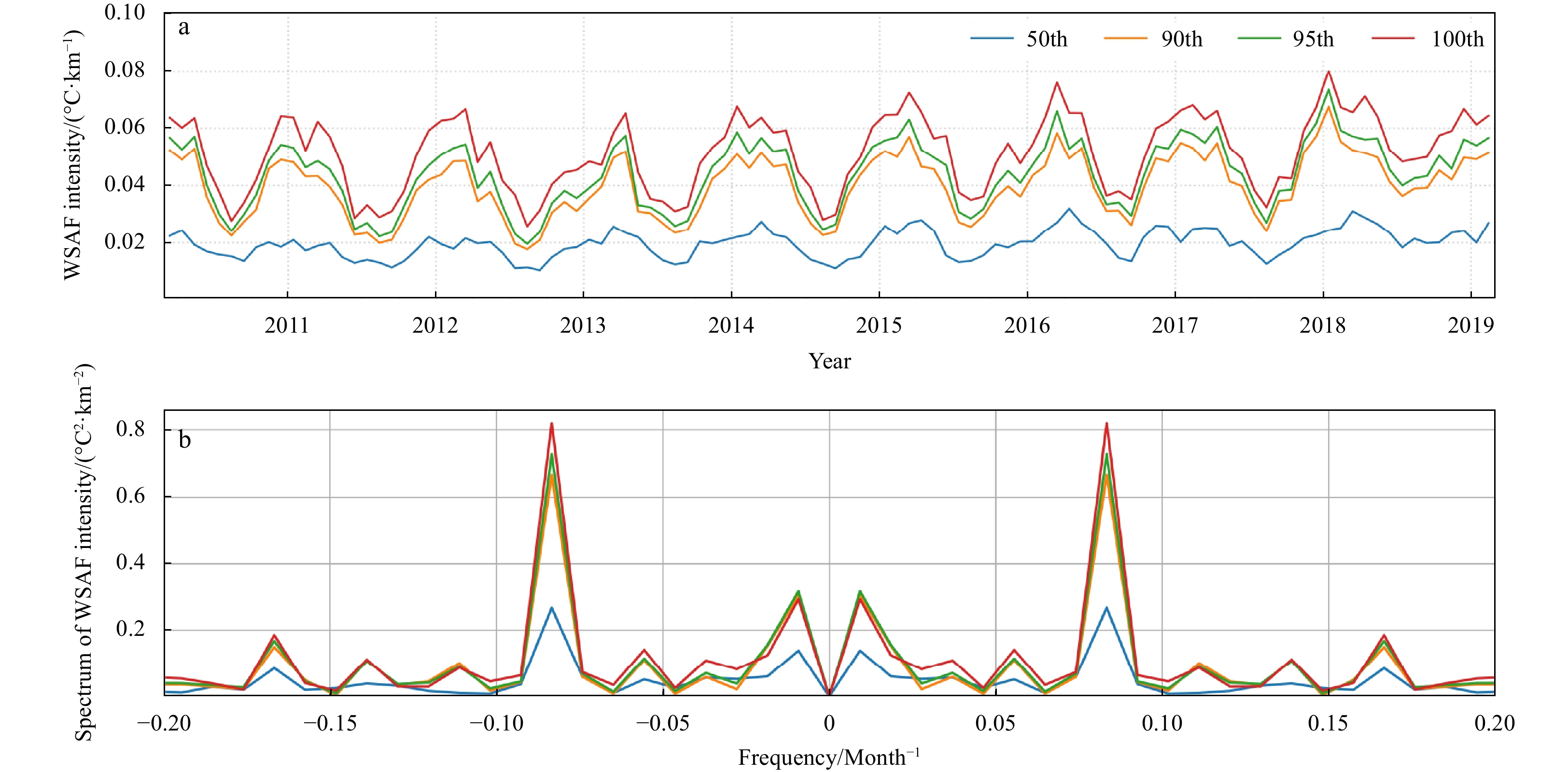
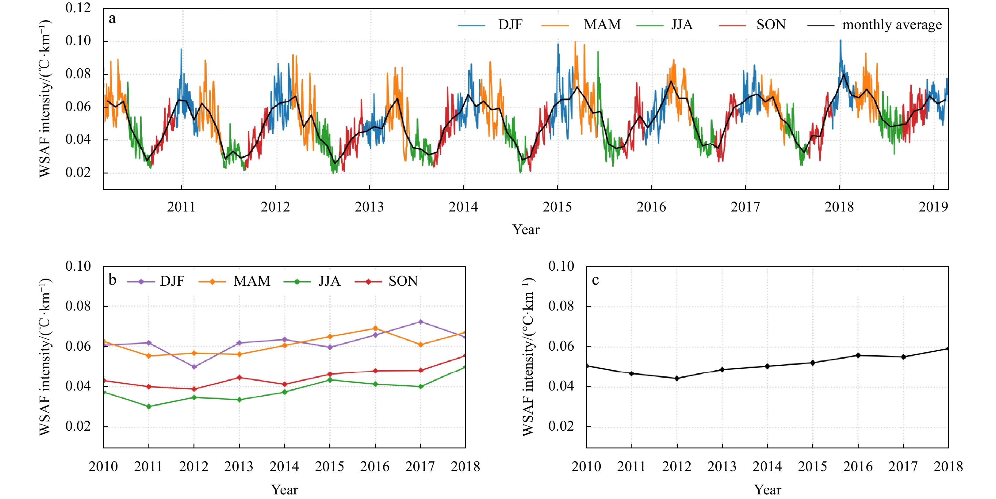
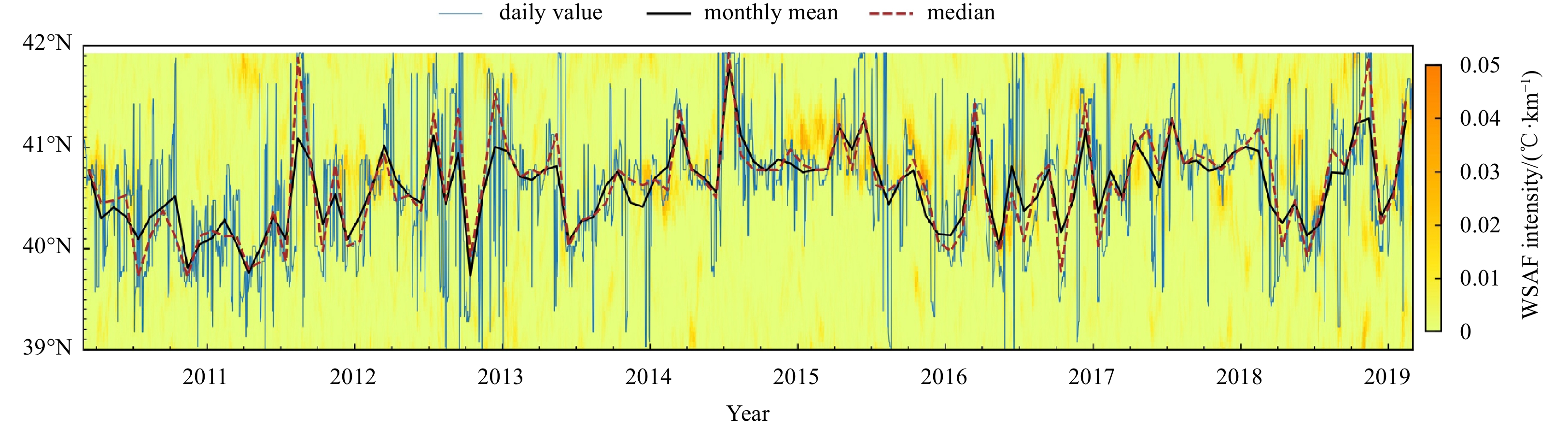
Oceanic front plays a significant role in the ocean vertical mixing and the regulation of air-sea interaction, among others. The western branch of the subarctic front (WSAF) located in the Northwest Pacific has attained lots of attention given its strong intensity and widespread influence on this region. In this study, we take advantage of the merged sea surface temperature (SST) at a high spatial resolution of 0.05° to investigate the characteristics of WSAF. The front detection algorithm that combines the Sobel operator and histogram analysis is adopted. It is advantageous in both preserving the front intensity represented by the SST gradient as well as reducing the detection noise level. We systematically applied this algorithm to the daily SST products for front detection, based on which the WSAF characteristics including its intensity, occurrence of frequency, latitudinal position and coverage area are then extracted. WSAF is mostly located within a small latitude range between 40°N and 41°N with a clear seasonal trend in its intensity that peaks in the winter and troughs in the summer. The seasonal variation of WSAF intensity is almost consistent throughout the temporal period of interest from 2010 to 2018. Similar seasonality is observed for its occurrence of frequency with the winter-summer contrast reaching up to 5%. The findings presented here shall help better interpret the WSAF characteristics in the long-term run as well as their impact on the regional weather and climate patterns at high spatial resolution.
Oceanic front plays a significant role in the ocean vertical mixing and the regulation of air-sea interaction, among others. The western branch of the subarctic front (WSAF) located in the Northwest Pacific has attained lots of attention given its strong intensity and widespread influence on this region. In this study, we take advantage of the merged sea surface temperature (SST) at a high spatial resolution of 0.05° to investigate the characteristics of WSAF. The front detection algorithm that combines the Sobel operator and histogram analysis is adopted. It is advantageous in both preserving the front intensity represented by the SST gradient as well as reducing the detection noise level. We systematically applied this algorithm to the daily SST products for front detection, based on which the WSAF characteristics including its intensity, occurrence of frequency, latitudinal position and coverage area are then extracted. WSAF is mostly located within a small latitude range between 40°N and 41°N with a clear seasonal trend in its intensity that peaks in the winter and troughs in the summer. The seasonal variation of WSAF intensity is almost consistent throughout the temporal period of interest from 2010 to 2018. Similar seasonality is observed for its occurrence of frequency with the winter-summer contrast reaching up to 5%. The findings presented here shall help better interpret the WSAF characteristics in the long-term run as well as their impact on the regional weather and climate patterns at high spatial resolution.


2023, 42(6): 33-38.
doi: 10.1007/s13131-022-2049-6
Abstract:
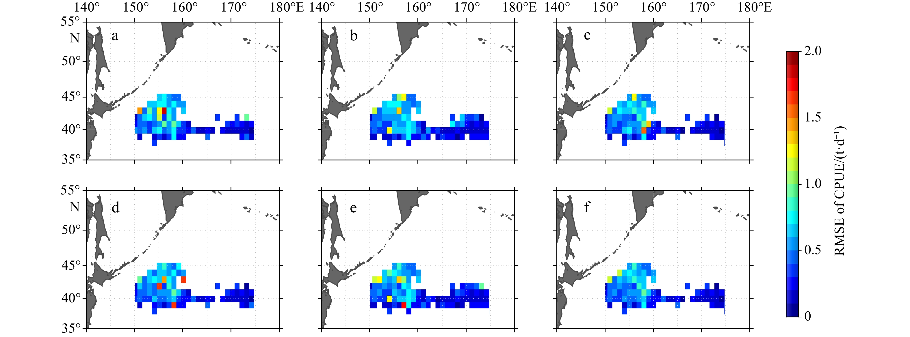
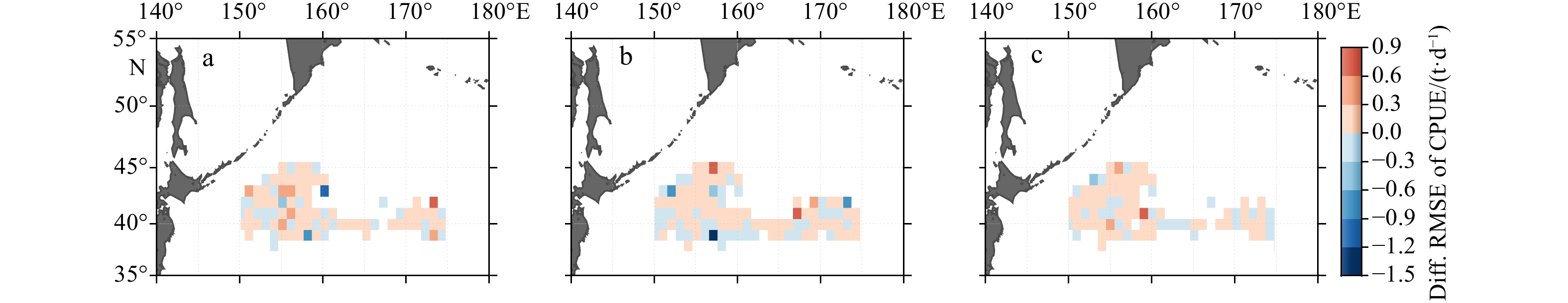
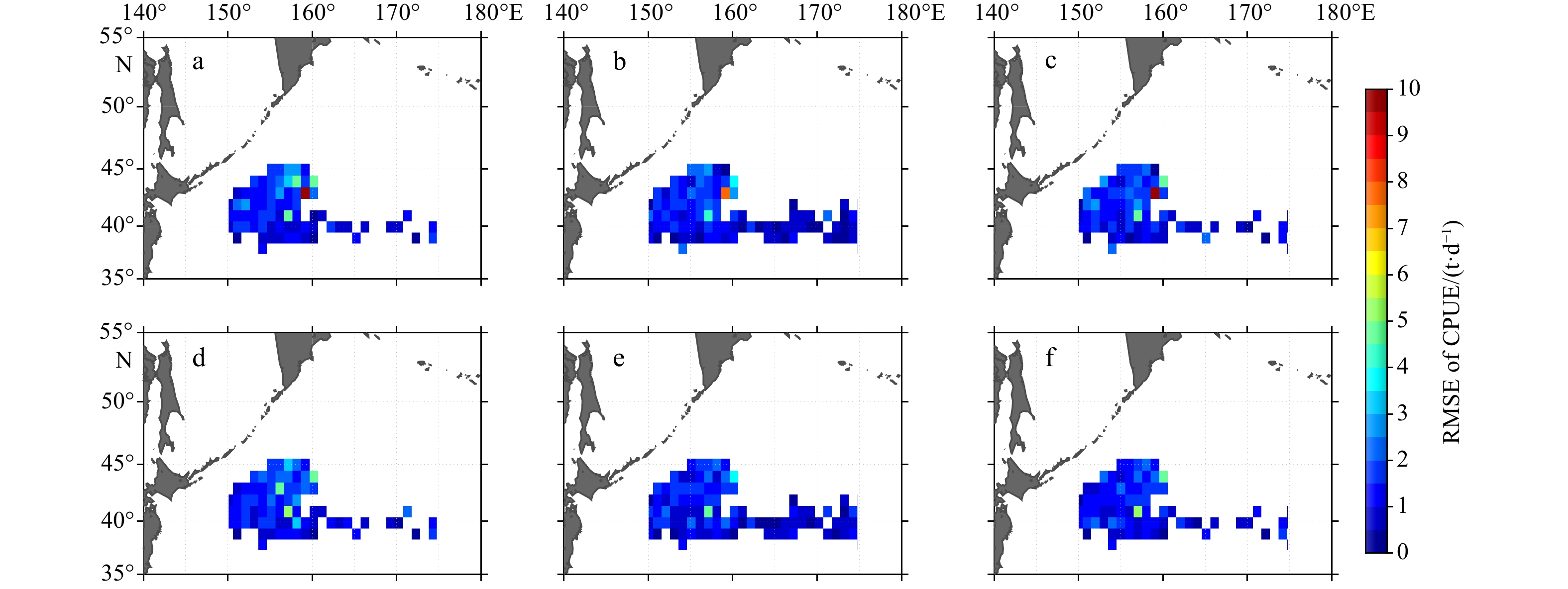
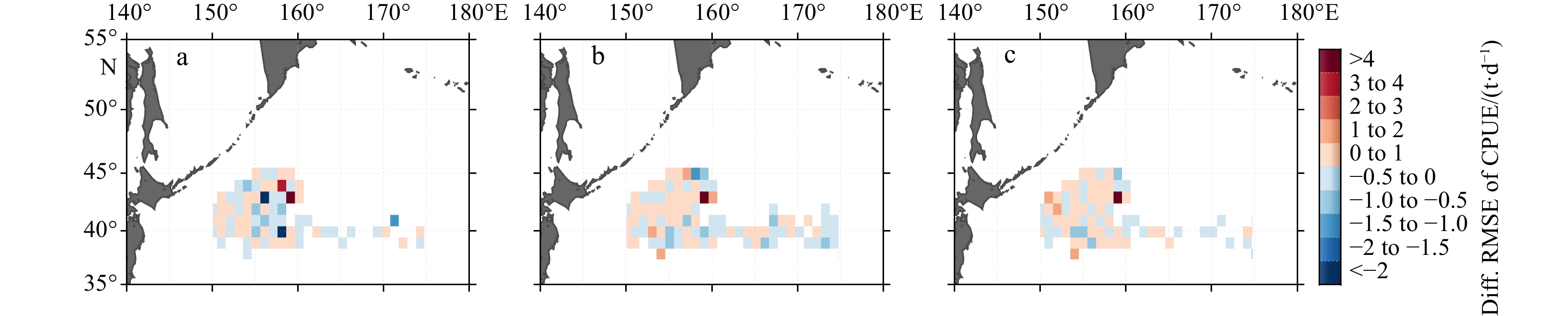
Accurately building the relationship between the oceanographic environment and the distribution of neon flying squid (Ommastrephes bartramii) is very important to understand the potential habitat pattern of O. bartramii. However, when building the prediction model of O. bartramii with traditional oceanographic variables (e.g., chlorophyll a concentration (Chl a) and sea surface temperature (SST)) from space-borne observations, part of the important spectrum characteristics of the oceanic surface could be masked by using the satellite data products directly. In this study, the neglected remote sensing information (i.e., spectral remote sensing reflectance (Rrs) and brightness temperature (BT)) is firstly incorporated to build the prediction model of catch per unit effort (CPUE) of O. bartramii from July to December during 2014–2018 in the Northwest Pacific Ocean. Results show that both the conventional oceanographic variables and the neglected remote sensing data are suitable for building the prediction model, whereas the overall root mean square error (RMSE) of the predicted CPUE of O. bartramii with the former is typically less accurate than that with the latter. Hence, the Rrs and BT could be a more suitable data source than the Chl a and SST to predict the distribution of O. bartramii, highlighting that the potential value of the neglected variables in understanding the habitat suitability of O. bartramii.
Accurately building the relationship between the oceanographic environment and the distribution of neon flying squid (Ommastrephes bartramii) is very important to understand the potential habitat pattern of O. bartramii. However, when building the prediction model of O. bartramii with traditional oceanographic variables (e.g., chlorophyll a concentration (Chl a) and sea surface temperature (SST)) from space-borne observations, part of the important spectrum characteristics of the oceanic surface could be masked by using the satellite data products directly. In this study, the neglected remote sensing information (i.e., spectral remote sensing reflectance (Rrs) and brightness temperature (BT)) is firstly incorporated to build the prediction model of catch per unit effort (CPUE) of O. bartramii from July to December during 2014–2018 in the Northwest Pacific Ocean. Results show that both the conventional oceanographic variables and the neglected remote sensing data are suitable for building the prediction model, whereas the overall root mean square error (RMSE) of the predicted CPUE of O. bartramii with the former is typically less accurate than that with the latter. Hence, the Rrs and BT could be a more suitable data source than the Chl a and SST to predict the distribution of O. bartramii, highlighting that the potential value of the neglected variables in understanding the habitat suitability of O. bartramii.
2023, 42(6): 39-48.
doi: 10.1007/s13131-022-2105-2
Abstract:
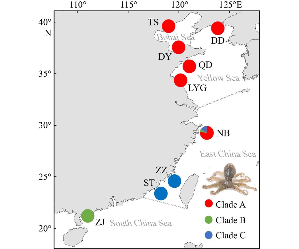
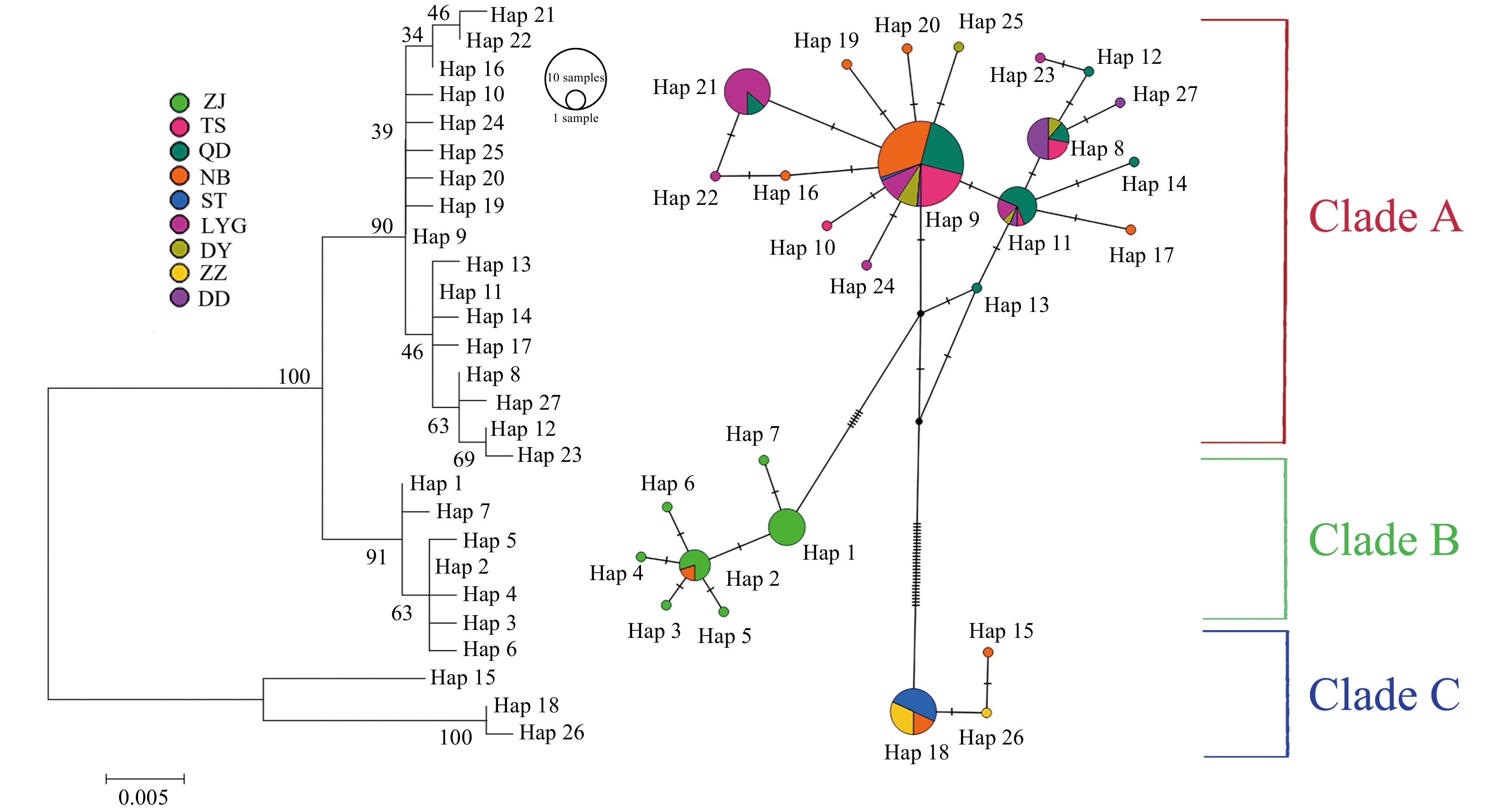
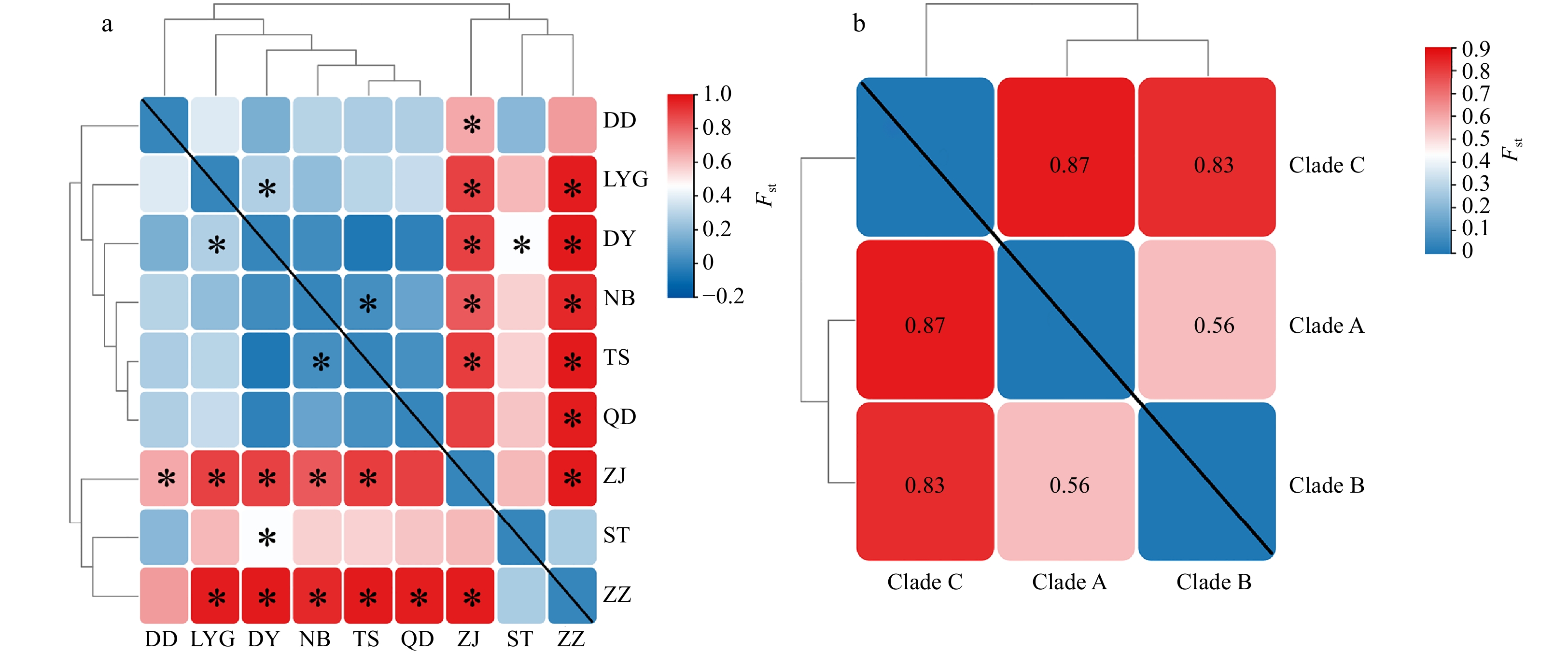
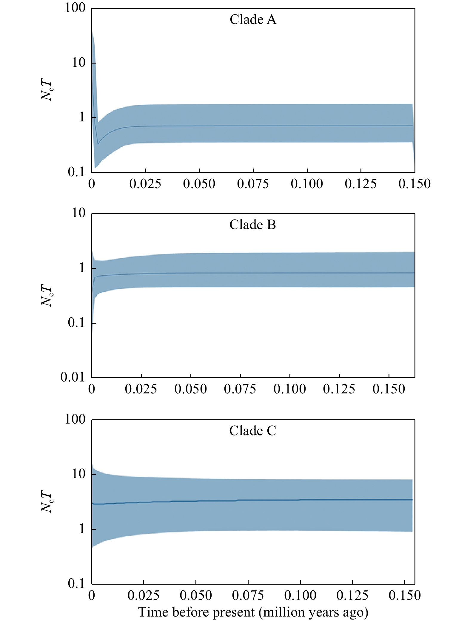
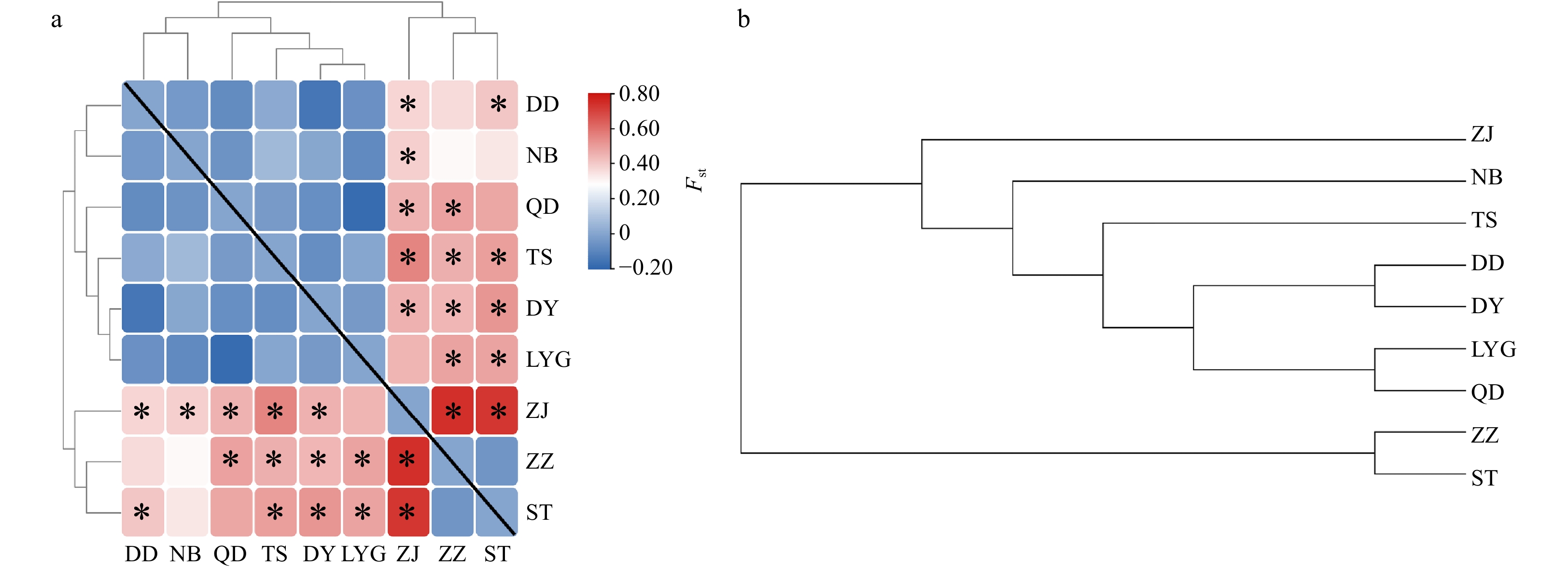
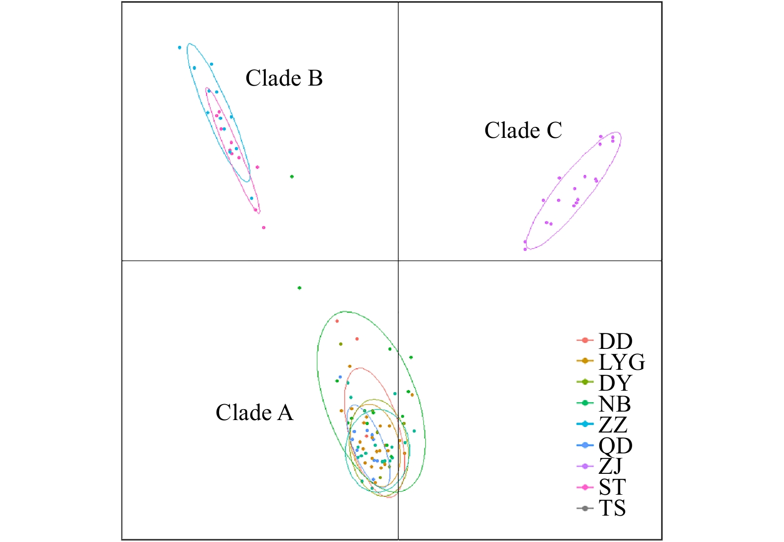
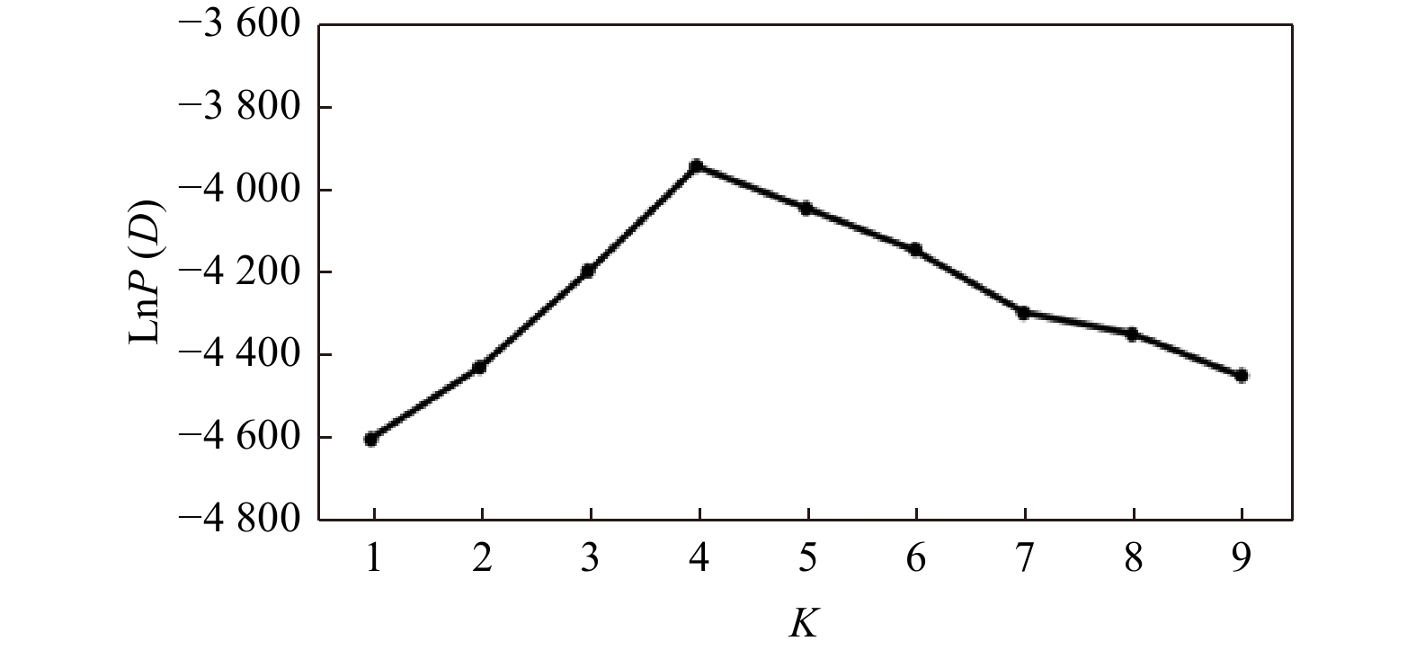
Amphioctopus fangsiao (Cephalopoda: Octopodidae) is an important commercial species in the coastal waters of China. In recent years, however, the resource of A. fangsiao have declined because of habitat destruction and overfishing. To analyze the genetic variations of A. fangsiao caused by the fluctuation of resources, the population genetic structure of nine sampling locations collected from the Bohai Sea to the South China Sea were investigated, using mtDNA COI fragments and microsatellite DNA. The results of F-statistics, AMOVA, STRUCTURE and PCA analyses showed three phylogeographic clades (Clades A, B and C), revealing limited genetic exchange between north and south populations. These clades diverged in 2.23 (Clades A and B) and 3.67 (Clades A, B and C) million years ago, during the dramatic environmental fluctuations, such as sea level and temperature changes, have exerted great influence on the survival distribution pattern of global organisms. Our results for low genetic connectivity among A. fangsiao populations provide insights into the development of management strategies, that is, to manage this species as separate management unit.
Amphioctopus fangsiao (Cephalopoda: Octopodidae) is an important commercial species in the coastal waters of China. In recent years, however, the resource of A. fangsiao have declined because of habitat destruction and overfishing. To analyze the genetic variations of A. fangsiao caused by the fluctuation of resources, the population genetic structure of nine sampling locations collected from the Bohai Sea to the South China Sea were investigated, using mtDNA COI fragments and microsatellite DNA. The results of F-statistics, AMOVA, STRUCTURE and PCA analyses showed three phylogeographic clades (Clades A, B and C), revealing limited genetic exchange between north and south populations. These clades diverged in 2.23 (Clades A and B) and 3.67 (Clades A, B and C) million years ago, during the dramatic environmental fluctuations, such as sea level and temperature changes, have exerted great influence on the survival distribution pattern of global organisms. Our results for low genetic connectivity among A. fangsiao populations provide insights into the development of management strategies, that is, to manage this species as separate management unit.
2023, 42(6): 49-56.
doi: 10.1007/s13131-022-2089-y
Abstract:
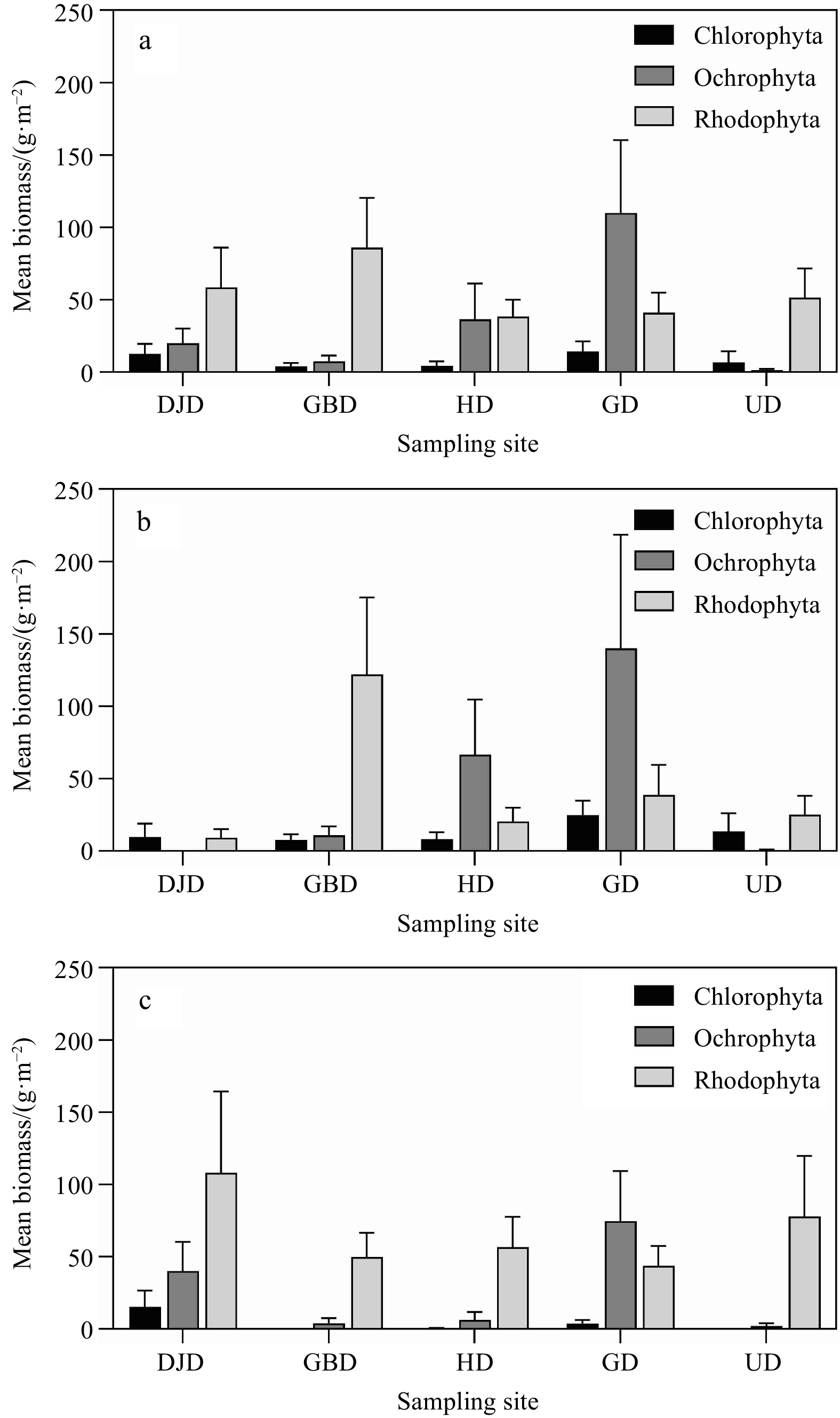
Macroalgae have long been used as biological indicators of marine ecosystem health worldwide due to their ecological importance and sensitivity to environmental stress. A number of previous studies have utilized macroalgal communities in monitoring surveys of environmental conditions. This study examined the characteristics and patterns of marine macroalgal communities in the Yellow Sea off the western coast of Korea. Macroalgae were analyzed for the number of species, biomass, and coverage ratio by macroalgal type. During the study period, 82 macroalgal species (10 green algae, 17 brown algae, and 55 red algae) were identified at the five study sites, with the highest number of species found at Gwanrido and Uido (both containing 41 species) and the lowest at Daeijakdo (27 species). The average biomass (via dry weight) was 98.63 g/m2, consisting of green algae (8.39 g/m2), brown algae (35.08 g/m2), and red algae (55.16 g/m2). The dominant macroalgae species in terms of biomass were Corallina pilulifera, Sargassum thunbergii, and Ulva australis in the intertidal zones, and Botryocladia wrightii and Gelidium elegans in the subtidal zones. Richness, evenness, and diversity indices based on the biomass of abundant species were 5.08, 0.65, and 2.30, respectively, over the entire study area. Based on the evaluation of the environmental states by the community indices, overall, the Ecological Evaluation Index of macroalgae communities in the study area was marked as “Good-Moderate”, but was determined as “Moderate-Low” at several sites during summer. The results can be a direct approach in the assessment of coastal habitats in which anthropogenic as well as climate change influences persist.
Macroalgae have long been used as biological indicators of marine ecosystem health worldwide due to their ecological importance and sensitivity to environmental stress. A number of previous studies have utilized macroalgal communities in monitoring surveys of environmental conditions. This study examined the characteristics and patterns of marine macroalgal communities in the Yellow Sea off the western coast of Korea. Macroalgae were analyzed for the number of species, biomass, and coverage ratio by macroalgal type. During the study period, 82 macroalgal species (10 green algae, 17 brown algae, and 55 red algae) were identified at the five study sites, with the highest number of species found at Gwanrido and Uido (both containing 41 species) and the lowest at Daeijakdo (27 species). The average biomass (via dry weight) was 98.63 g/m2, consisting of green algae (8.39 g/m2), brown algae (35.08 g/m2), and red algae (55.16 g/m2). The dominant macroalgae species in terms of biomass were Corallina pilulifera, Sargassum thunbergii, and Ulva australis in the intertidal zones, and Botryocladia wrightii and Gelidium elegans in the subtidal zones. Richness, evenness, and diversity indices based on the biomass of abundant species were 5.08, 0.65, and 2.30, respectively, over the entire study area. Based on the evaluation of the environmental states by the community indices, overall, the Ecological Evaluation Index of macroalgae communities in the study area was marked as “Good-Moderate”, but was determined as “Moderate-Low” at several sites during summer. The results can be a direct approach in the assessment of coastal habitats in which anthropogenic as well as climate change influences persist.
2023, 42(6): 57-69.
doi: 10.1007/s13131-022-2090-5
Abstract:
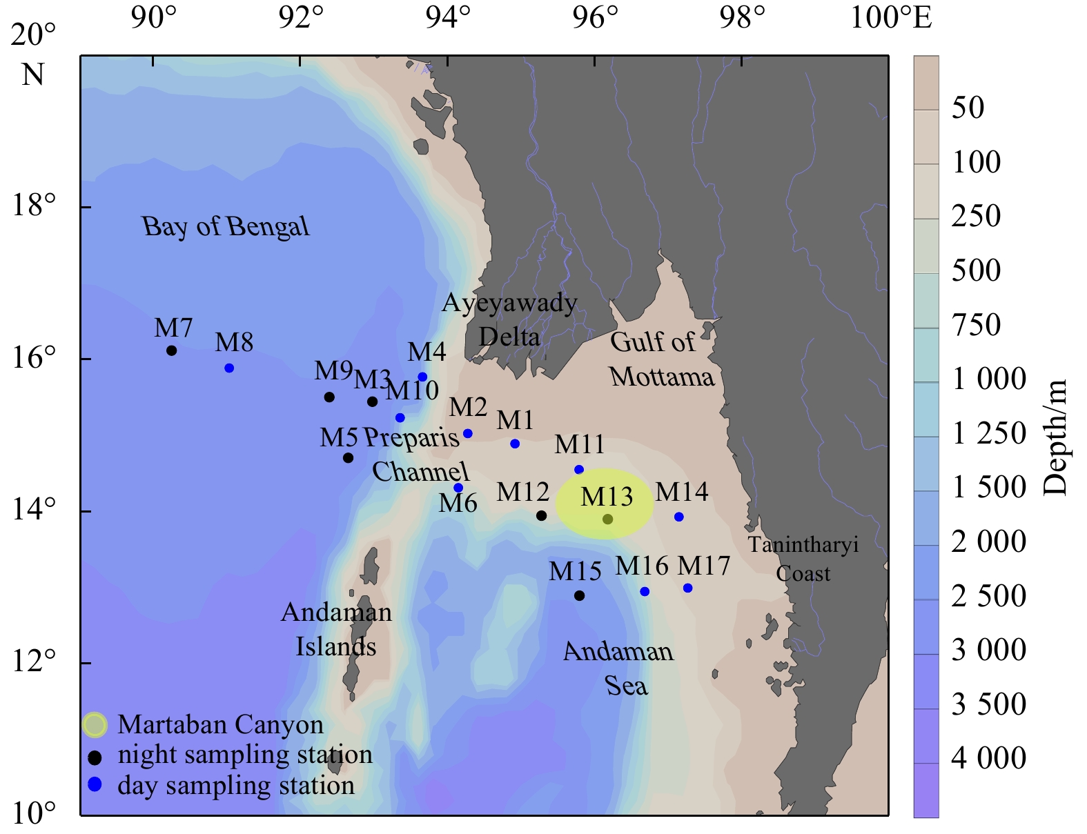
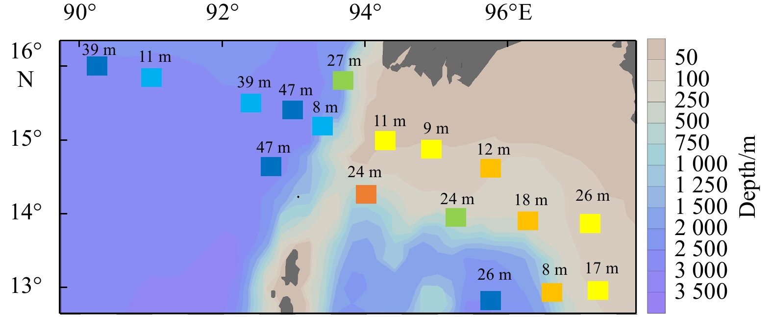
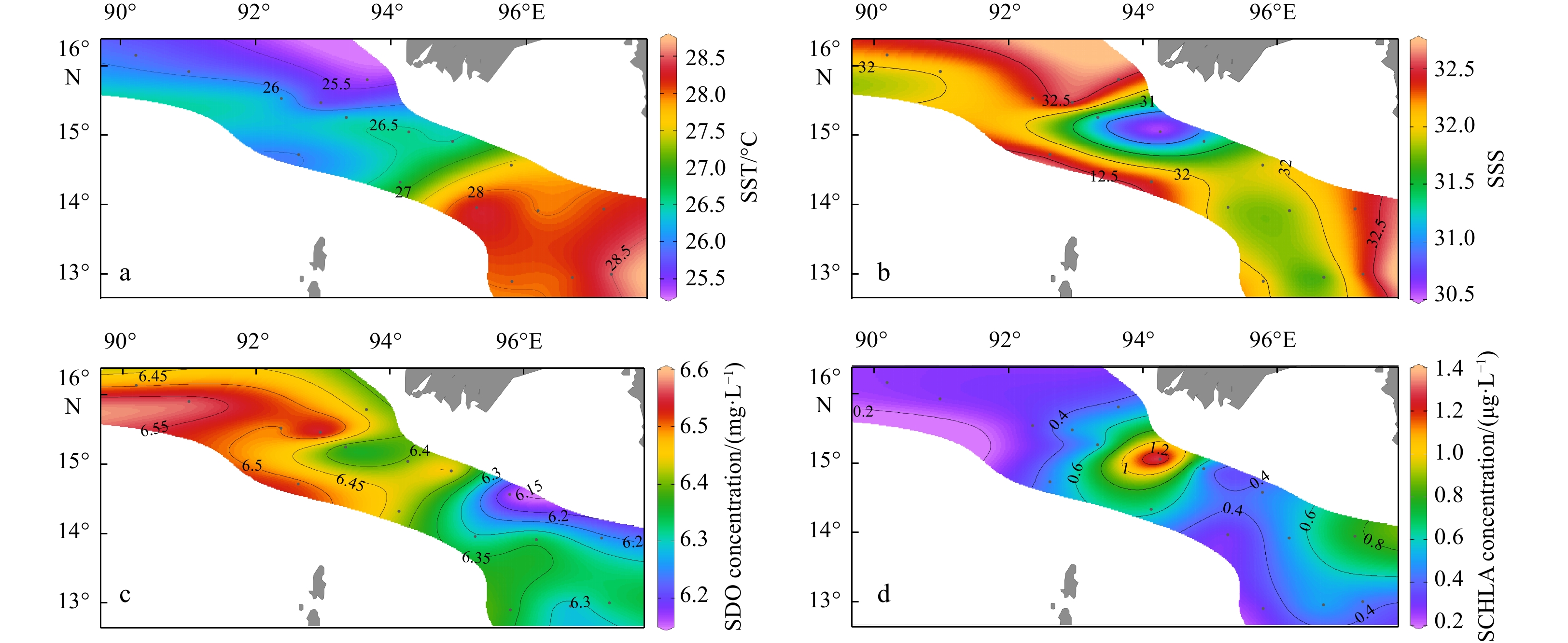
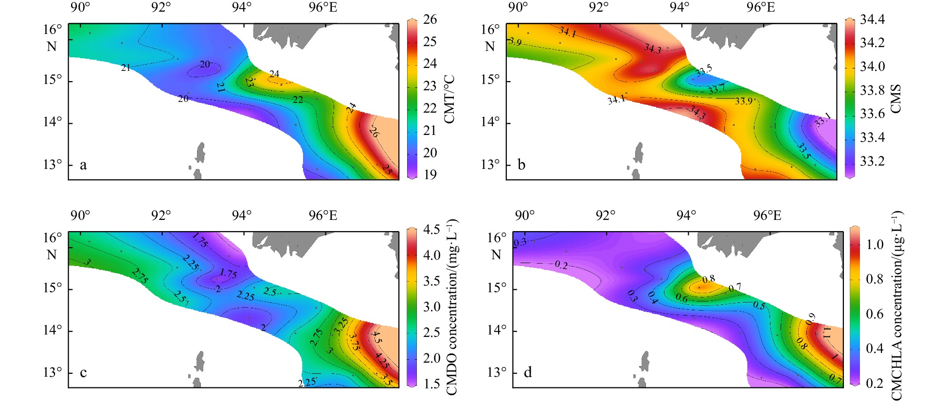
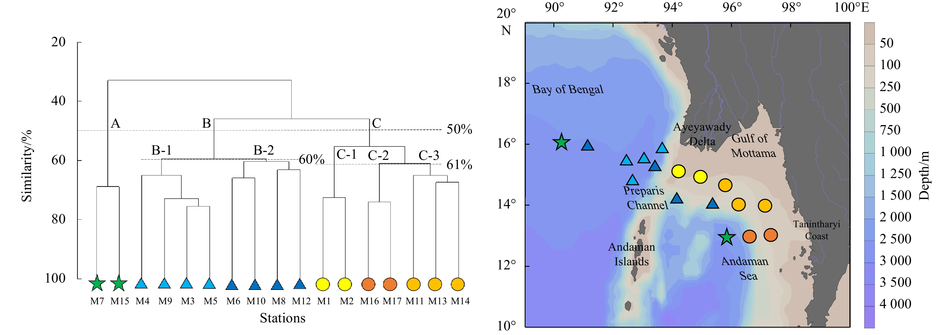
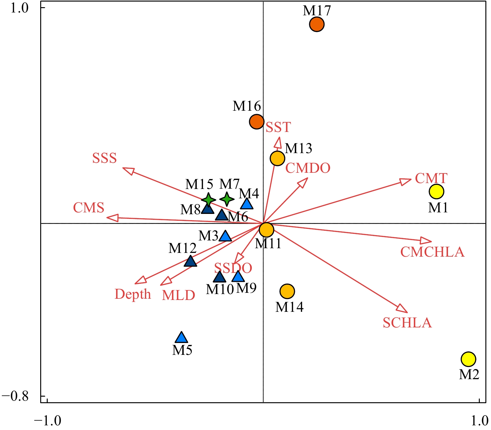
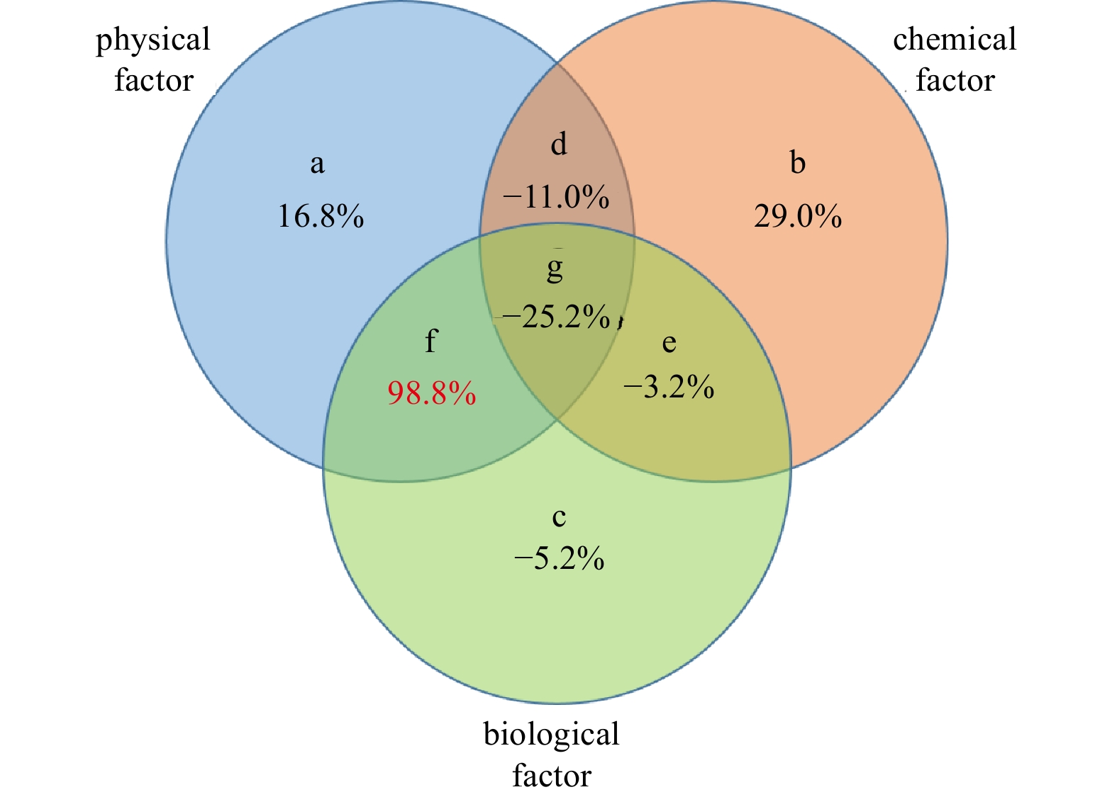
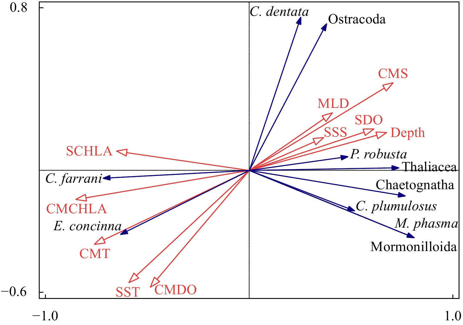
The northern Andaman Sea off Myanmar is one of the relatively high productive regions in the Indian Ocean. The abundance, biomass and species composition of mesozooplankton and their relationships with environmental variables in the epipelagic zone (~200 m) were studied for the first time during the Sino-Myanmar joint cruise (February 2020). The mean abundance and biomass of mesozooplankton were (1916.7±1192.9) ind./m3 and (17.8±7.9) mg/m3, respectively. A total of 213 species (taxa) were identified from all samples. The omnivorous Cyclopoida Oncaea venusta and Oithona spp. were the top two dominant taxa. Three mesozooplankton communities were determined via cluster analysis: the open ocean in the Andaman Sea and the Bay of Bengal (Group A), the transition zone across the Preparis Channel (Group B), and nearshore water off the Ayeyarwady Delta and along the Tanintharyi Coast (Group C). Variation partitioning analysis revealed that the interaction of physical and biological factors explained 98.8% of mesozooplankton community spatial variation, and redundancy analysis revealed that column mean chlorophyll a concentration (CMCHLA) was the most important explanatory variable (43.1%). The abundance and biomass were significantly higher in Group C, the same as CMCHLA and column mean temperature (CMT) and in contrast to salinity, and CMT was the dominant factor. Significant taxon spatial variations were controlled by CMCHLA, salinity and temperature. This study suggested that mesozooplankton spatial variation was mainly regulated by physical processes through their effects on CMCHLA. The physical processes were simultaneously affected by heat loss differences, freshwater influx, eddies and depth.
The northern Andaman Sea off Myanmar is one of the relatively high productive regions in the Indian Ocean. The abundance, biomass and species composition of mesozooplankton and their relationships with environmental variables in the epipelagic zone (~200 m) were studied for the first time during the Sino-Myanmar joint cruise (February 2020). The mean abundance and biomass of mesozooplankton were (1916.7±1192.9) ind./m3 and (17.8±7.9) mg/m3, respectively. A total of 213 species (taxa) were identified from all samples. The omnivorous Cyclopoida Oncaea venusta and Oithona spp. were the top two dominant taxa. Three mesozooplankton communities were determined via cluster analysis: the open ocean in the Andaman Sea and the Bay of Bengal (Group A), the transition zone across the Preparis Channel (Group B), and nearshore water off the Ayeyarwady Delta and along the Tanintharyi Coast (Group C). Variation partitioning analysis revealed that the interaction of physical and biological factors explained 98.8% of mesozooplankton community spatial variation, and redundancy analysis revealed that column mean chlorophyll a concentration (CMCHLA) was the most important explanatory variable (43.1%). The abundance and biomass were significantly higher in Group C, the same as CMCHLA and column mean temperature (CMT) and in contrast to salinity, and CMT was the dominant factor. Significant taxon spatial variations were controlled by CMCHLA, salinity and temperature. This study suggested that mesozooplankton spatial variation was mainly regulated by physical processes through their effects on CMCHLA. The physical processes were simultaneously affected by heat loss differences, freshwater influx, eddies and depth.


2023, 42(6): 70-77.
doi: 10.1007/s13131-022-2095-0
Abstract:
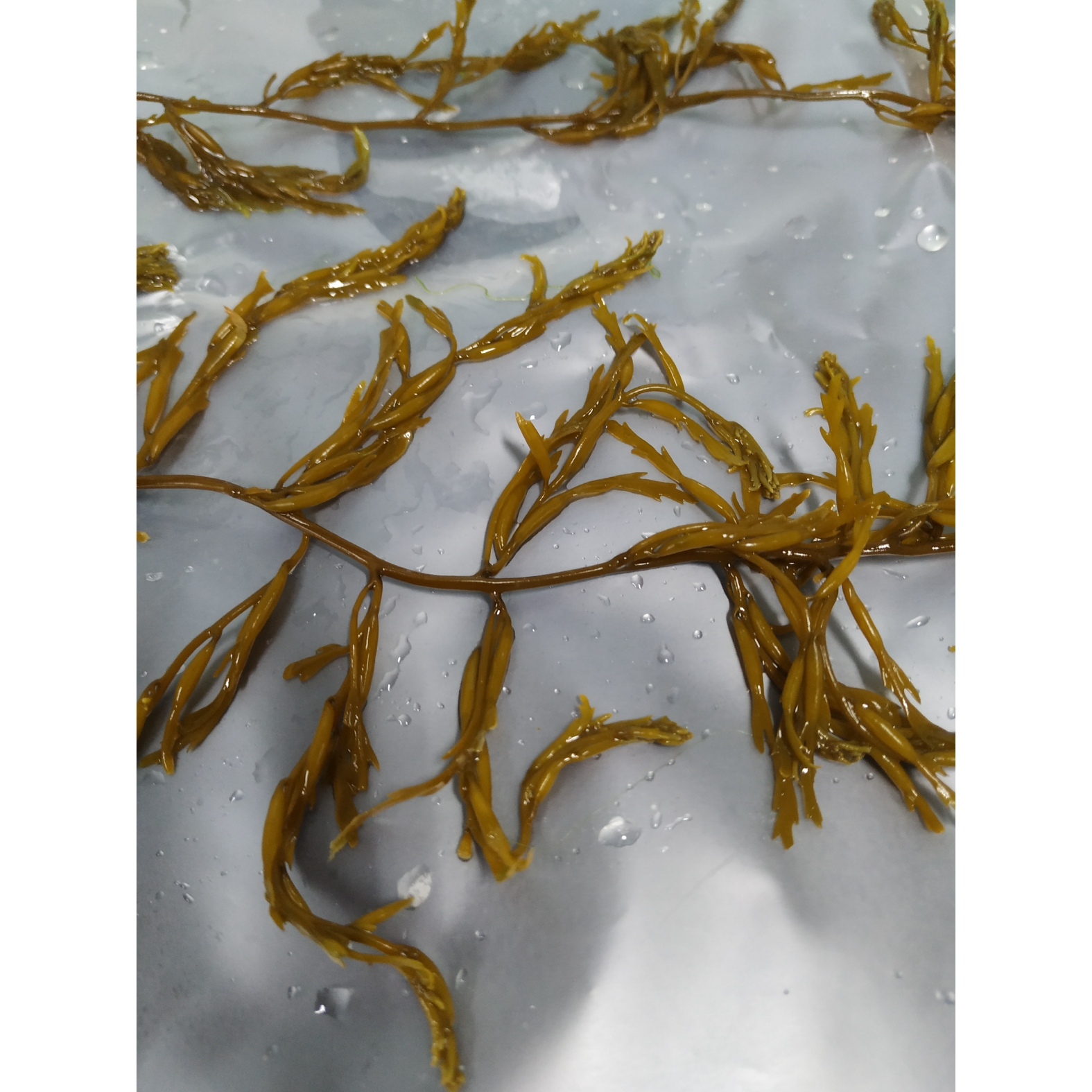
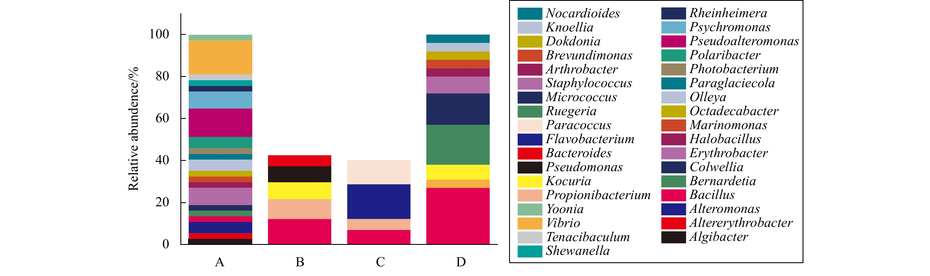
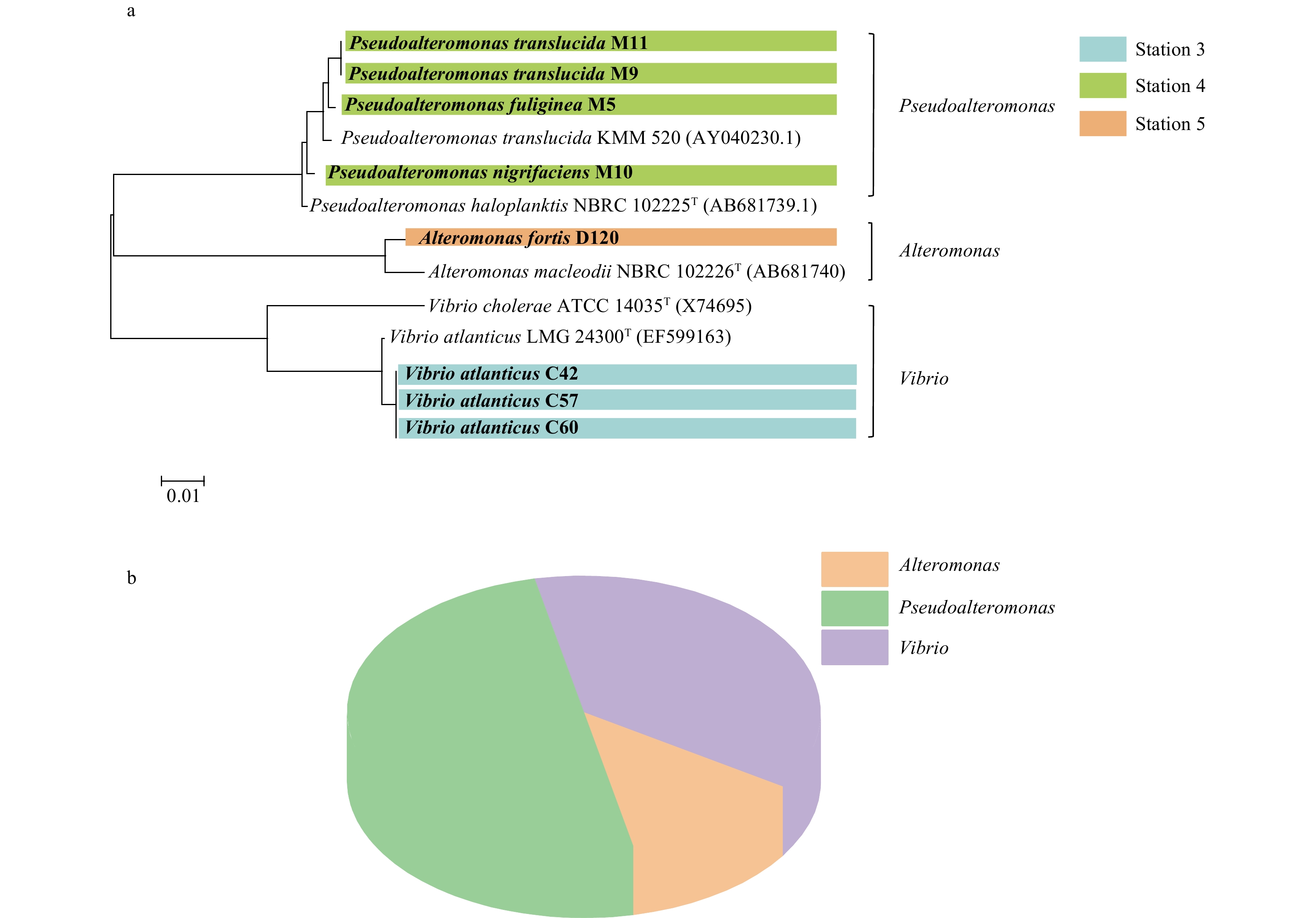
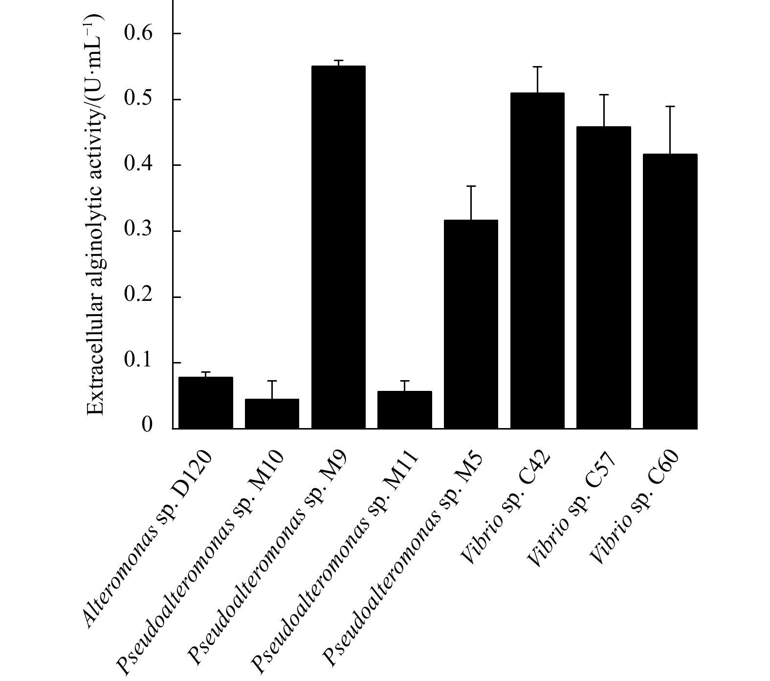
Large numbers of bacteria live on the surface of various brown algae and can produce alginate lyases to consume alginate, an important component of the cell wall of brown algae. Sargassum is a genus of the largest canopy-forming brown algae of more than 150 species, which are widely distributed in tropical and subtropical environments. However, our knowledge about the epiphytic bacteria and the alginate lyase-excreting bacteria from Sargassum is still primitive. Here, we investigated the diversity of the culturable epiphytic bacteria and alginate-degrading bacteria from Sargassum samples collected from the coastal seawaters of Shandong Province, China. In total, 37 strains belonging to 21 genera in 3 phyla were isolated, including 15 previously unreported genera, of which Vibrio (6/37) and Pseudoalteromonas (5/37) are the dominant genera. Eight strains, mainly Vibrio and Pseudoalteromonas species, were further identified as alginate lyase-excreting strains that can utilize alginate for growth. The extracellular alginolytic activity of the 8 strains was determined, and strains Vibrio sp. C42 and Pseudoalteromonas sp. M9 showed the highest activity. These results provide a better understanding of brown algae epiphytes and alginate-degrading bacteria, and are fundamental for further studies on the interactions between brown algae and their epiphytes.
Large numbers of bacteria live on the surface of various brown algae and can produce alginate lyases to consume alginate, an important component of the cell wall of brown algae. Sargassum is a genus of the largest canopy-forming brown algae of more than 150 species, which are widely distributed in tropical and subtropical environments. However, our knowledge about the epiphytic bacteria and the alginate lyase-excreting bacteria from Sargassum is still primitive. Here, we investigated the diversity of the culturable epiphytic bacteria and alginate-degrading bacteria from Sargassum samples collected from the coastal seawaters of Shandong Province, China. In total, 37 strains belonging to 21 genera in 3 phyla were isolated, including 15 previously unreported genera, of which Vibrio (6/37) and Pseudoalteromonas (5/37) are the dominant genera. Eight strains, mainly Vibrio and Pseudoalteromonas species, were further identified as alginate lyase-excreting strains that can utilize alginate for growth. The extracellular alginolytic activity of the 8 strains was determined, and strains Vibrio sp. C42 and Pseudoalteromonas sp. M9 showed the highest activity. These results provide a better understanding of brown algae epiphytes and alginate-degrading bacteria, and are fundamental for further studies on the interactions between brown algae and their epiphytes.


2023, 42(6): 78-88.
doi: 10.1007/s13131-022-2109-y
Abstract:
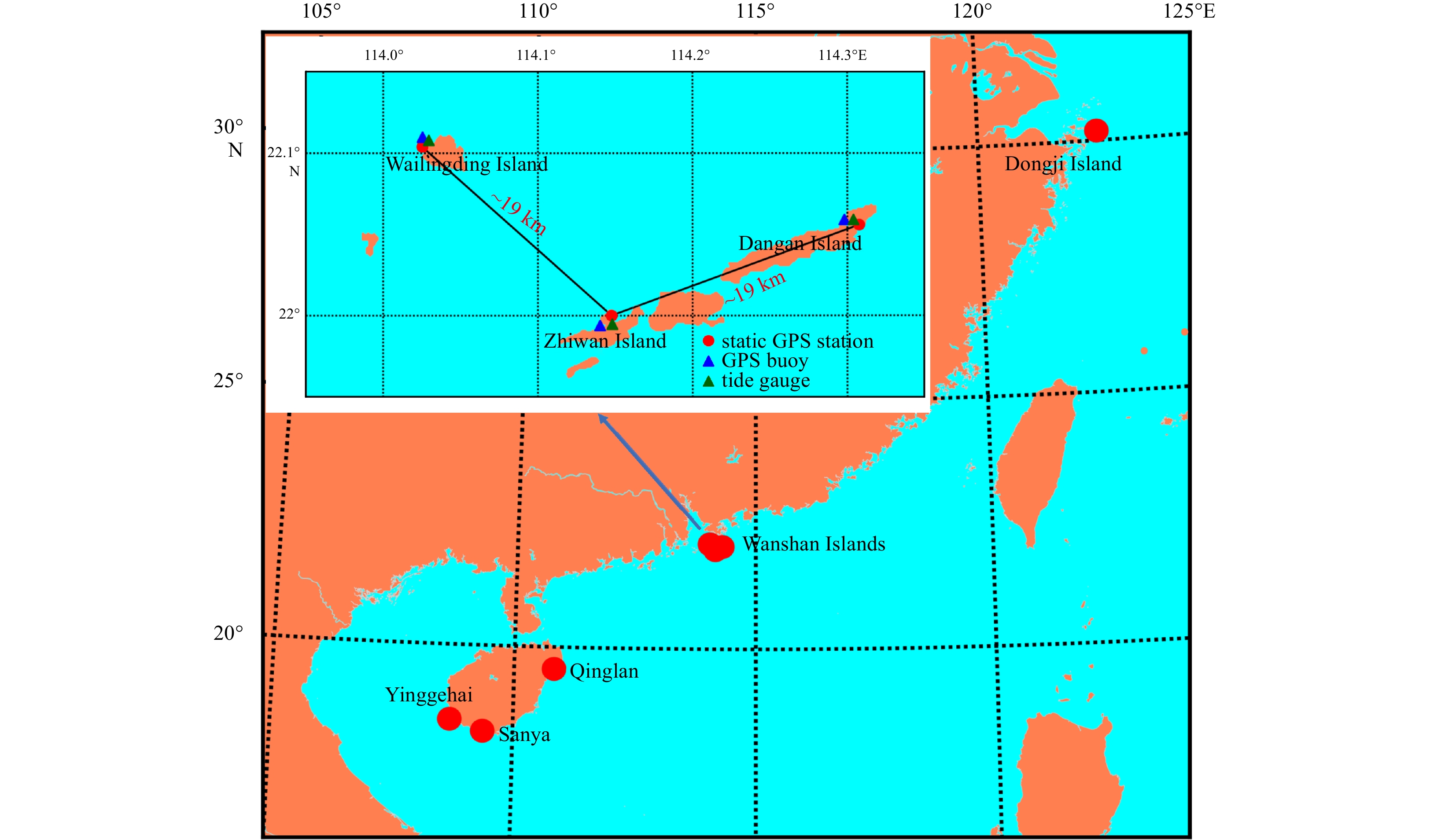
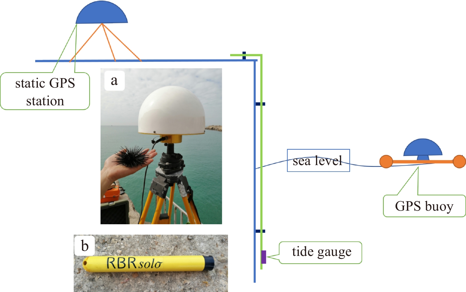
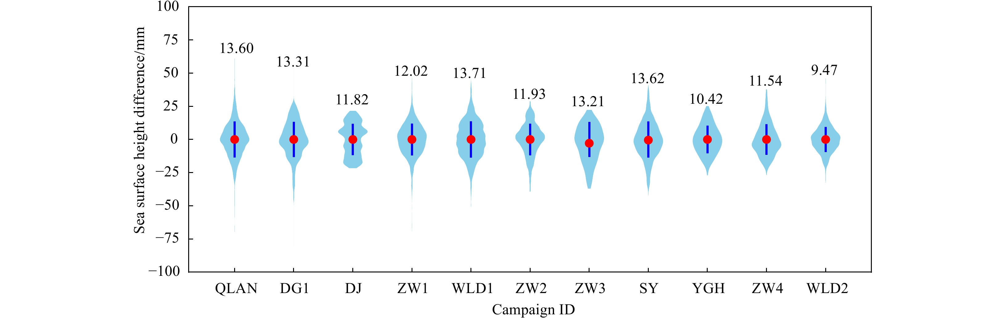
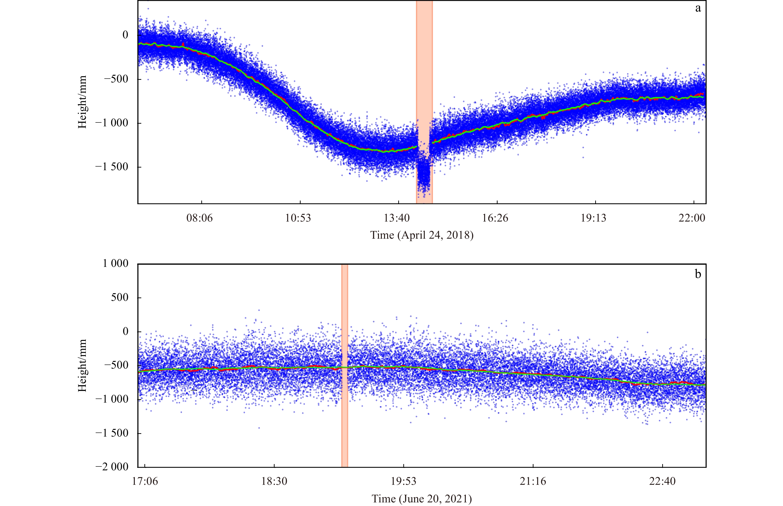
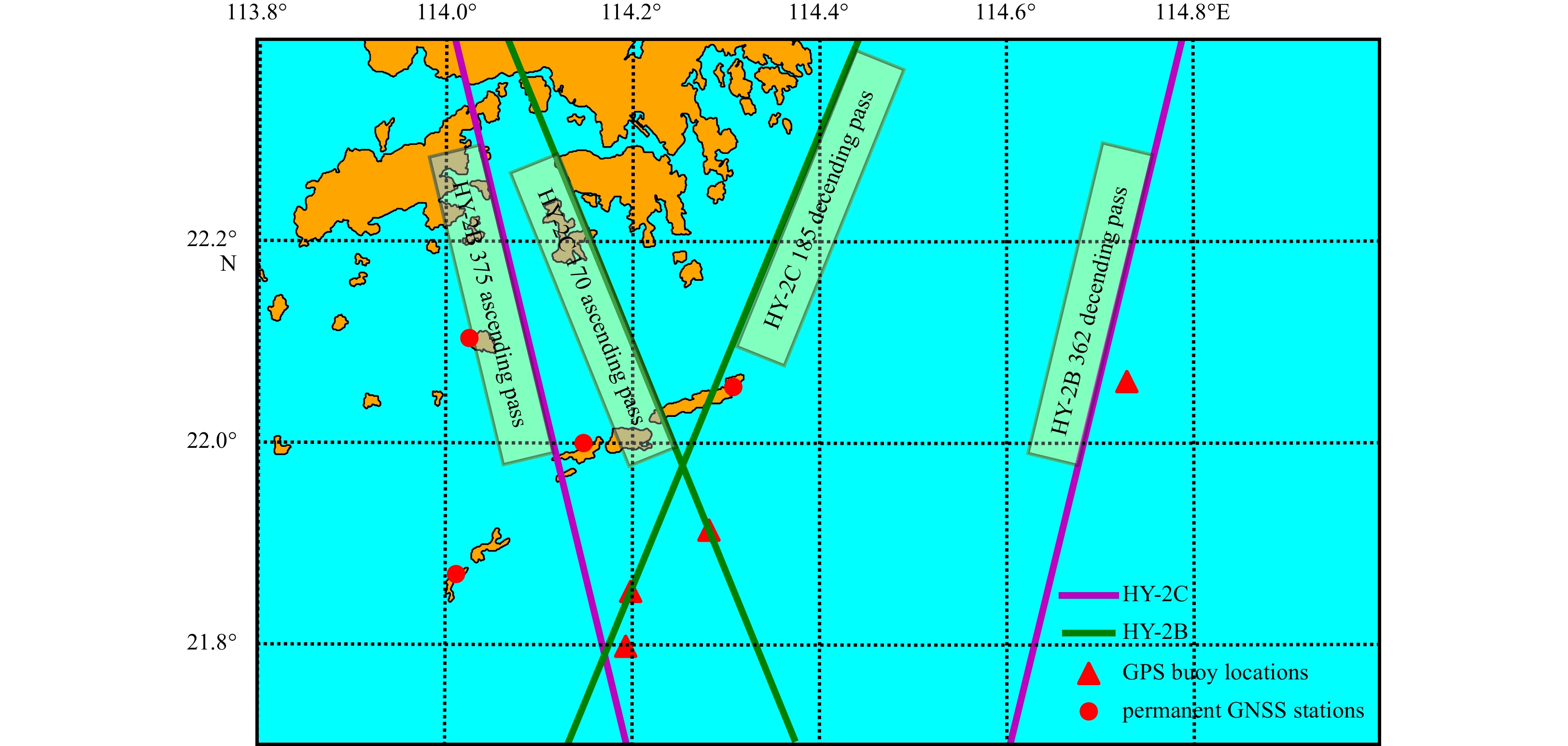
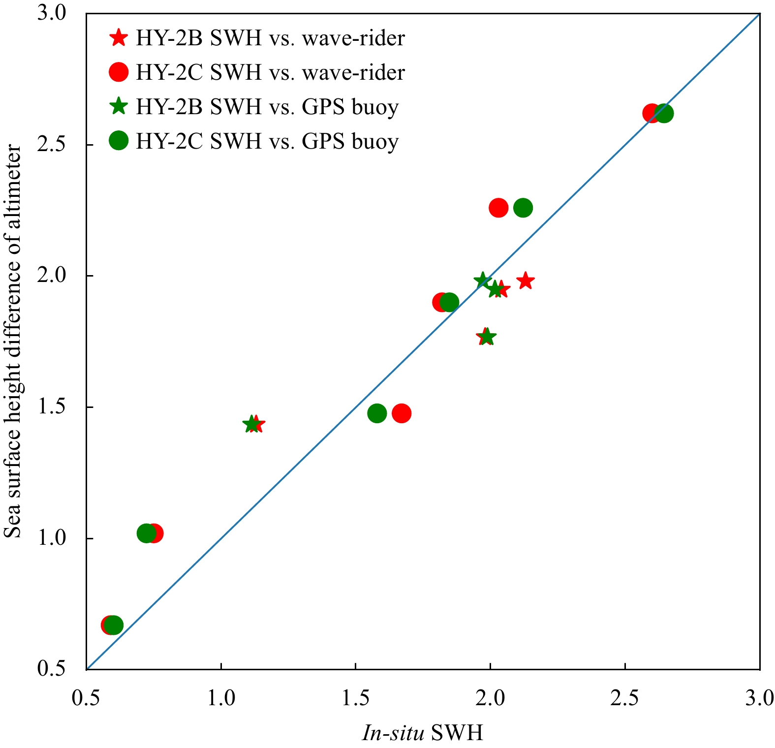
A dedicated GPS buoy is designed for calibration and validation (Cal/Val) of satellite altimeters since 2014. In order to evaluate the accuracy of the sea surface height (SSH) measured by the GPS buoy, twelve campaigns have been done within China sea area between 2014 and 2021. In six of these campaigns, two static Global Navigation Satellite System stations were installed at distances of <1 km and 19 km from the buoy to assess how the baseline length influenced the derived SSH from the buoy solutions. The GPS buoy data was processed using the GAMIT/GLOBK software+TRACK module and CSRS-PPP tool to achieve the SSH. The SSH was compared with conventionally tide gauge (TG) data to evaluate the accuracy of the buoy with the standard deviation of the height element. The results showed that the difference in the standard deviation of the SSH from the buoy and the TG was less than 16 mm. The SSHs processed with different ephemeris (Ultra-Rapid, Rapid, Final) were not significantly different. When the baseline length was 19 km, the SSH solution of the GPS buoy performed well, with standard bias of less than 26 mm between the heights measured by the buoy and TG, meaning that the buoy could be used for Cal/Val of altimeters. The bias between the Canadian Spatial Reference System-precise point positioning tool and the TRACK varied a lot, and some of them were over 130 mm. This deemed too high to be useful for Cal/Val of satellite altimeters. Moreover, the GPS buoy solutions processed by GAMIT/GLOBK software+TRACK module were used for in-orbit Cal/Val of HY-2B/C satellites in ten campaigns. The SSH and significant wave height of the altimeters showed good agreements with the GPS buoy solutions.
A dedicated GPS buoy is designed for calibration and validation (Cal/Val) of satellite altimeters since 2014. In order to evaluate the accuracy of the sea surface height (SSH) measured by the GPS buoy, twelve campaigns have been done within China sea area between 2014 and 2021. In six of these campaigns, two static Global Navigation Satellite System stations were installed at distances of <1 km and 19 km from the buoy to assess how the baseline length influenced the derived SSH from the buoy solutions. The GPS buoy data was processed using the GAMIT/GLOBK software+TRACK module and CSRS-PPP tool to achieve the SSH. The SSH was compared with conventionally tide gauge (TG) data to evaluate the accuracy of the buoy with the standard deviation of the height element. The results showed that the difference in the standard deviation of the SSH from the buoy and the TG was less than 16 mm. The SSHs processed with different ephemeris (Ultra-Rapid, Rapid, Final) were not significantly different. When the baseline length was 19 km, the SSH solution of the GPS buoy performed well, with standard bias of less than 26 mm between the heights measured by the buoy and TG, meaning that the buoy could be used for Cal/Val of altimeters. The bias between the Canadian Spatial Reference System-precise point positioning tool and the TRACK varied a lot, and some of them were over 130 mm. This deemed too high to be useful for Cal/Val of satellite altimeters. Moreover, the GPS buoy solutions processed by GAMIT/GLOBK software+TRACK module were used for in-orbit Cal/Val of HY-2B/C satellites in ten campaigns. The SSH and significant wave height of the altimeters showed good agreements with the GPS buoy solutions.


2023, 42(6): 89-99.
doi: 10.1007/s13131-022-2143-9
Abstract:
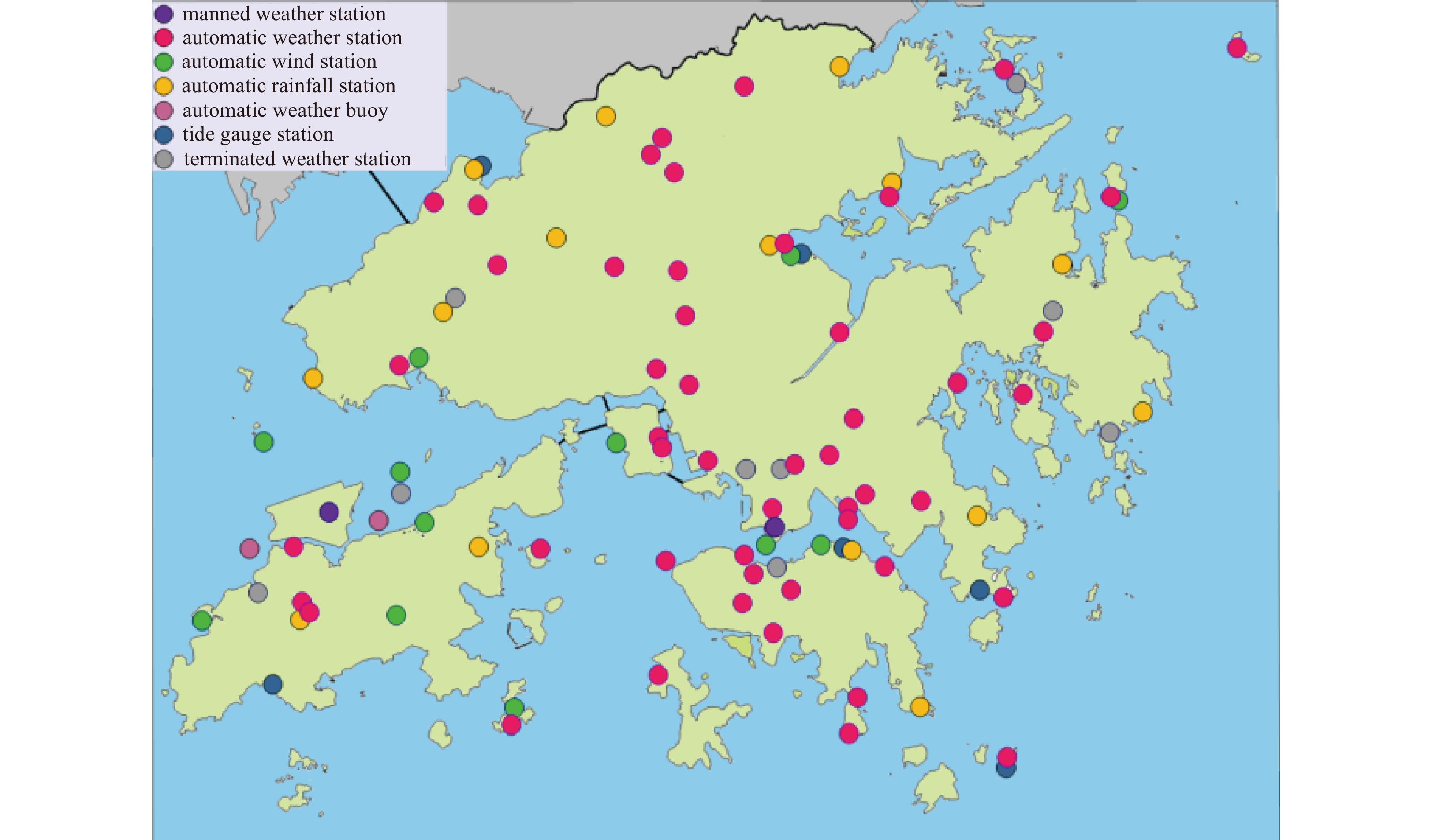
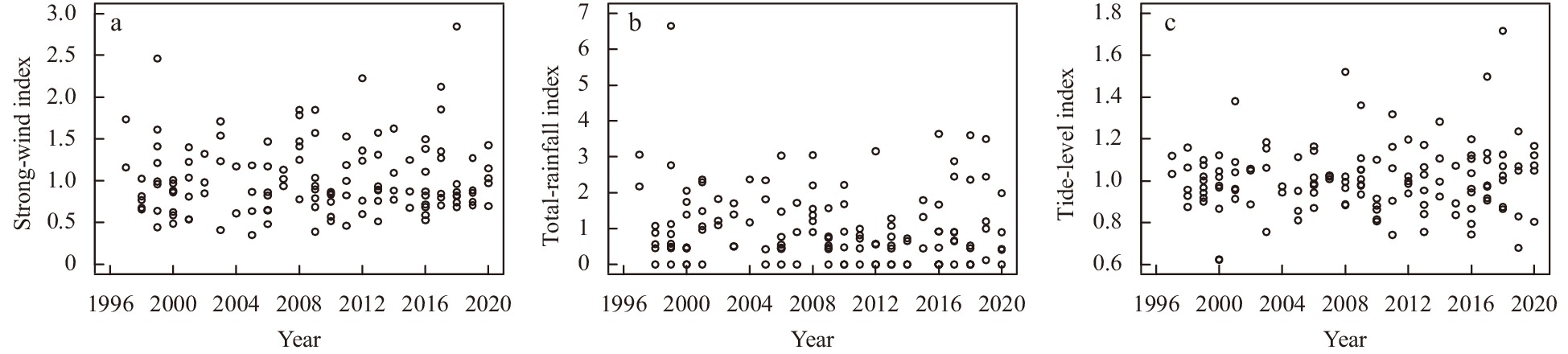
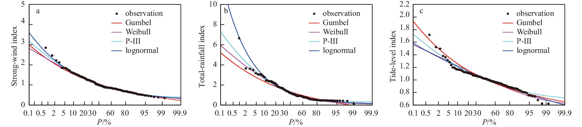
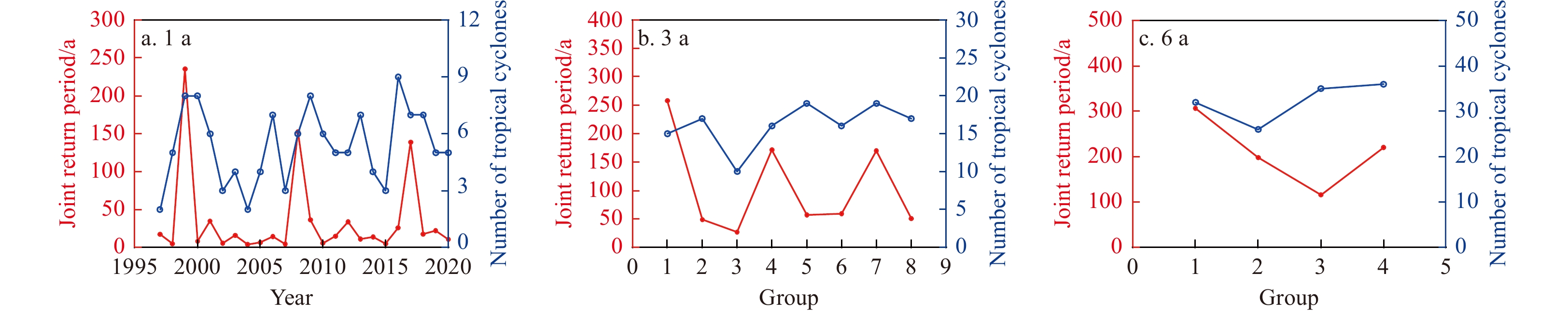
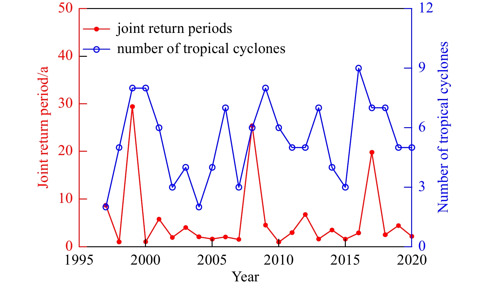
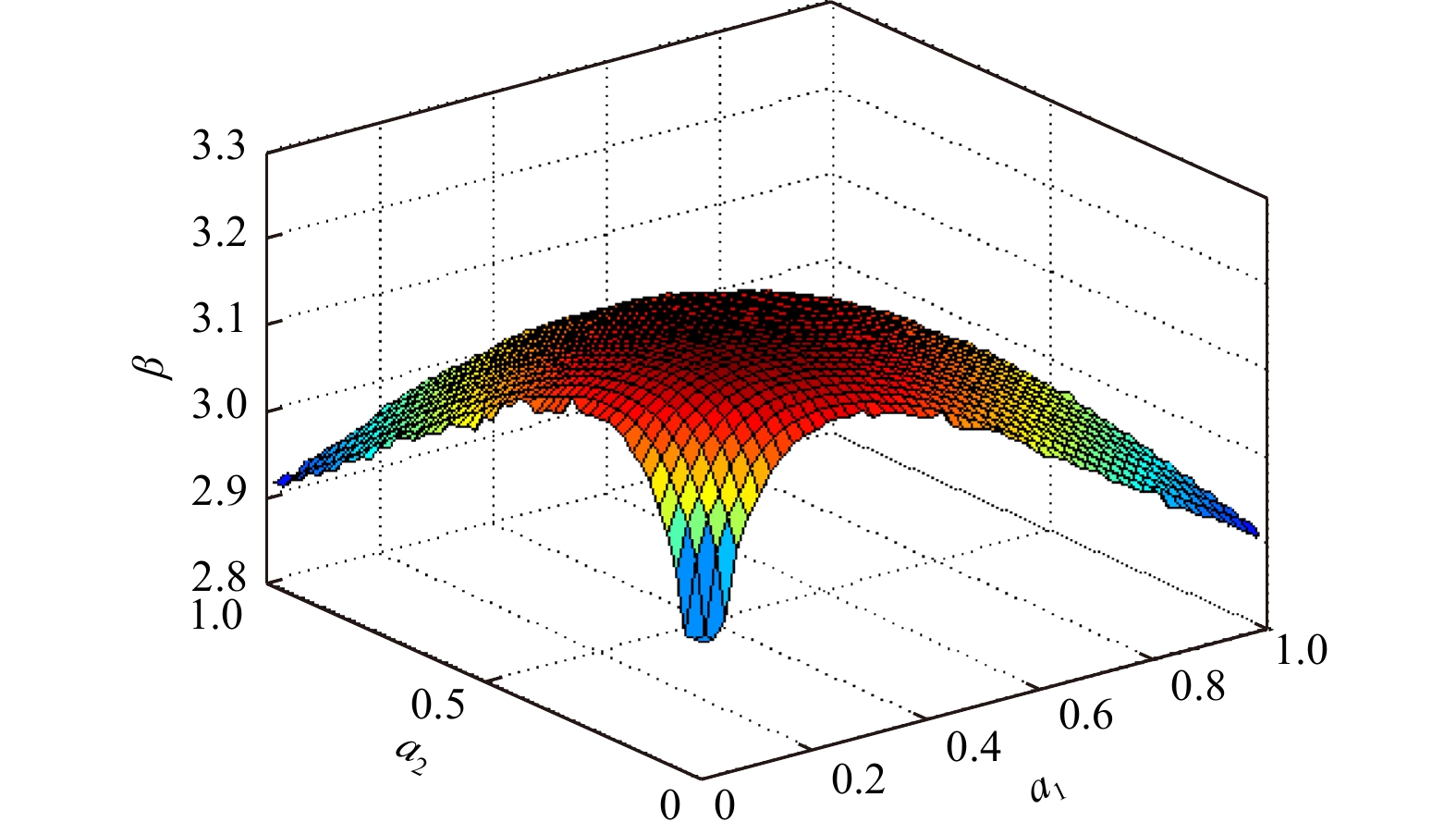
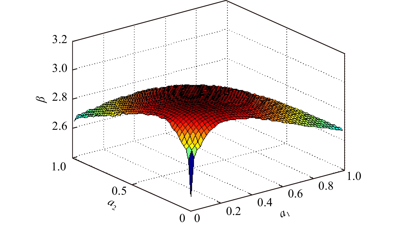
The main hazard-causing factors of tropical cyclones are strong wind, heavy rainfall, and storm surge. Evaluation of the hazard-causing degree of a tropical cyclone requires a joint intensity analysis of these hazard-causing factors. According to the maximum hourly mean wind speed, total rainfall, and maximum tide level at various observation stations in Hong Kong during these tropical cyclones, three hazard-causing indices for tropical cyclones are introduced: the strong-wind index (VI), total-rainfall index (RI), and tide-level index (LI). Through a joint probability analysis of VI, RI, and LI for a tropical cyclone affecting Hong Kong, the joint return period is calculated to evaluate its joint hazard-causing intensity. A limit state function of Hong Kong’s resistance to tropical cyclones is developed and used to evaluate the regional risk of tropical cyclones affecting Hong Kong. The results indicate that the joint return period of VI, RI, and LI can reflect the joint hazard-causing intensity of strong wind, heavy rain, and storm surge caused by tropical cyclones; if the overall design return periods of the regional structures decrease, the regional ability to defend against tropical cyclone disasters is degraded.
The main hazard-causing factors of tropical cyclones are strong wind, heavy rainfall, and storm surge. Evaluation of the hazard-causing degree of a tropical cyclone requires a joint intensity analysis of these hazard-causing factors. According to the maximum hourly mean wind speed, total rainfall, and maximum tide level at various observation stations in Hong Kong during these tropical cyclones, three hazard-causing indices for tropical cyclones are introduced: the strong-wind index (VI), total-rainfall index (RI), and tide-level index (LI). Through a joint probability analysis of VI, RI, and LI for a tropical cyclone affecting Hong Kong, the joint return period is calculated to evaluate its joint hazard-causing intensity. A limit state function of Hong Kong’s resistance to tropical cyclones is developed and used to evaluate the regional risk of tropical cyclones affecting Hong Kong. The results indicate that the joint return period of VI, RI, and LI can reflect the joint hazard-causing intensity of strong wind, heavy rain, and storm surge caused by tropical cyclones; if the overall design return periods of the regional structures decrease, the regional ability to defend against tropical cyclone disasters is degraded.


2023, 42(6): 100-111.
doi: 10.1007/s13131-022-2144-8
Abstract:
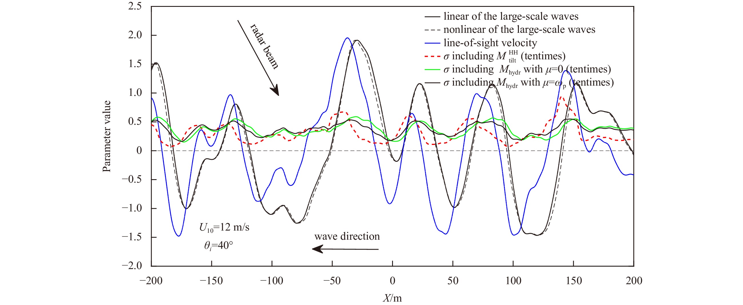
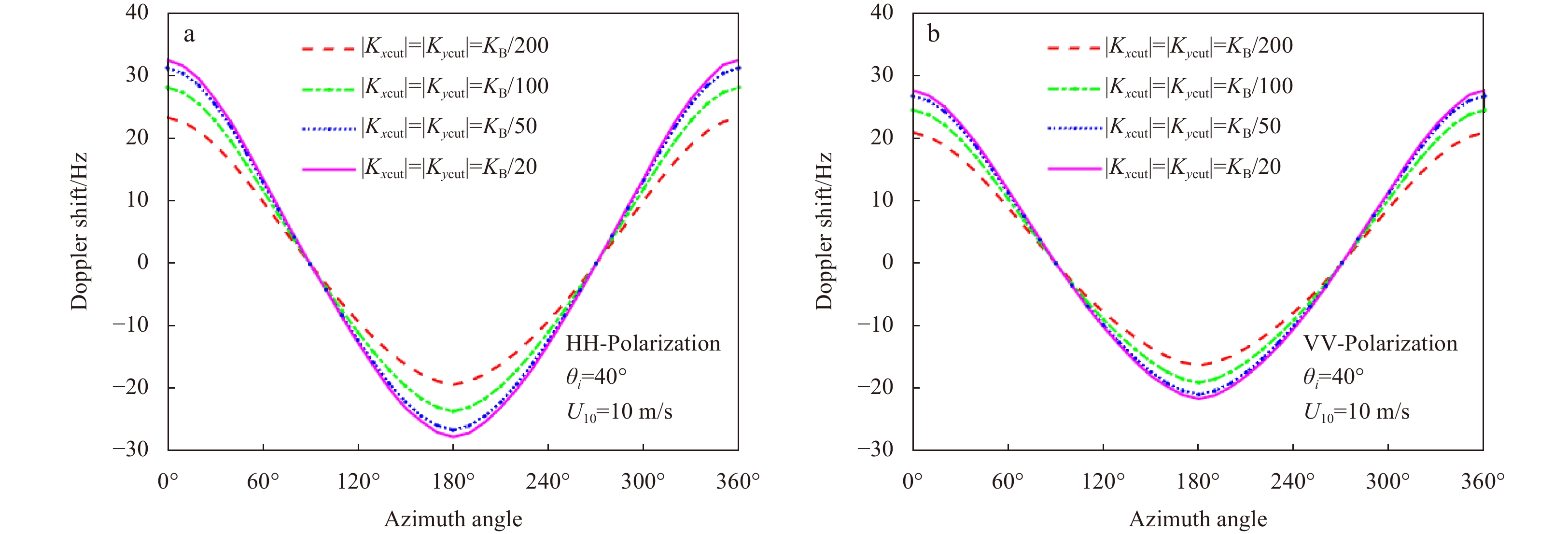
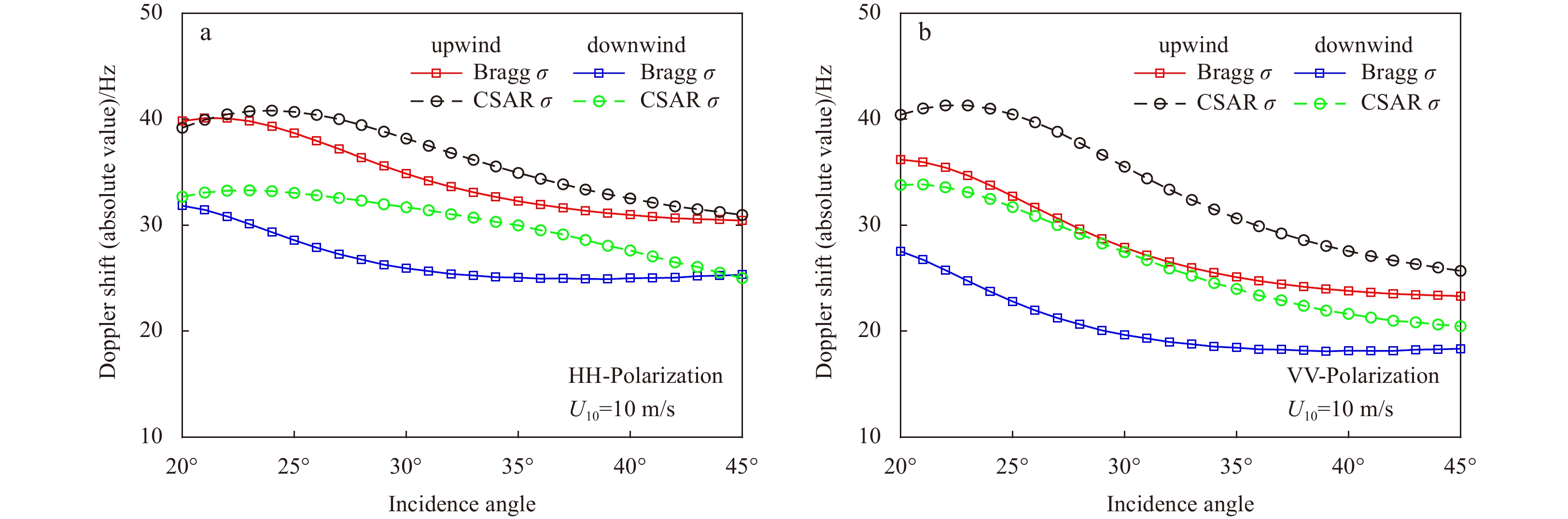
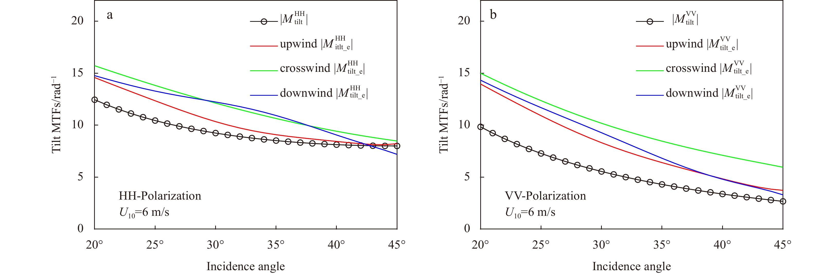
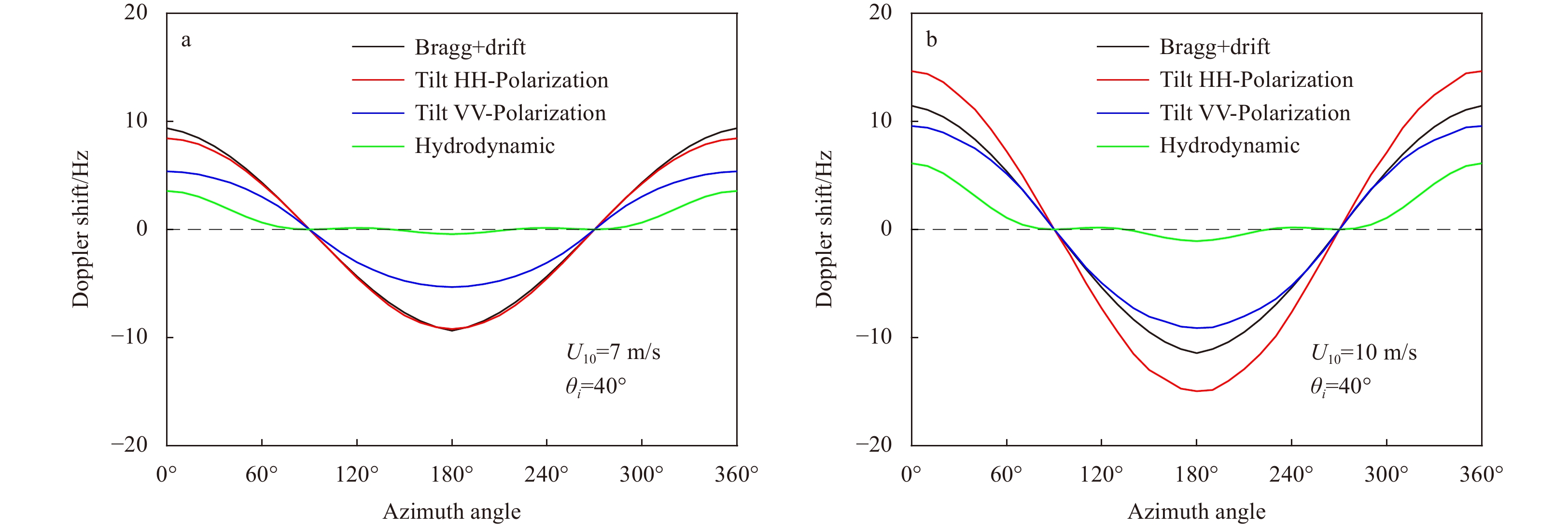
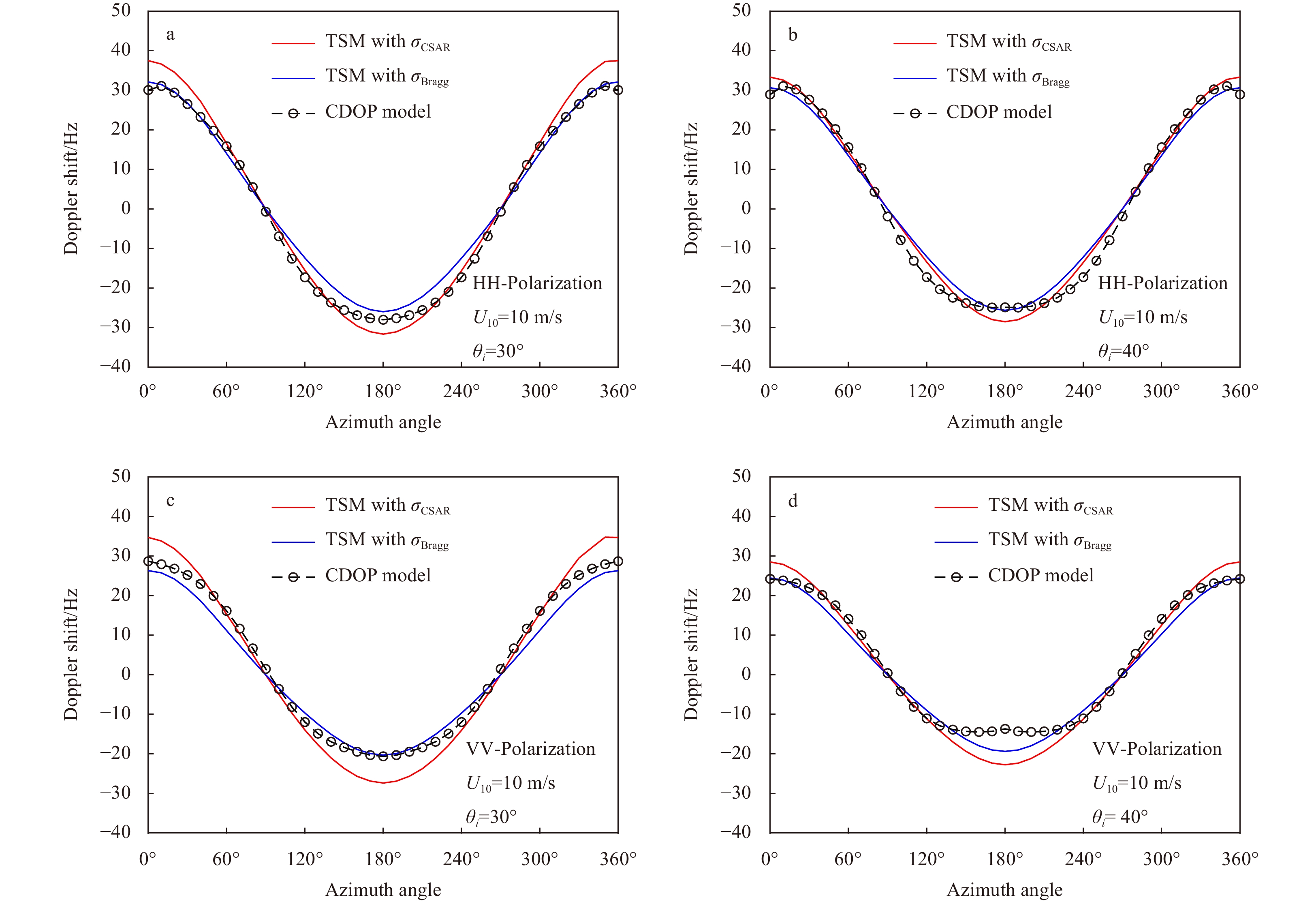
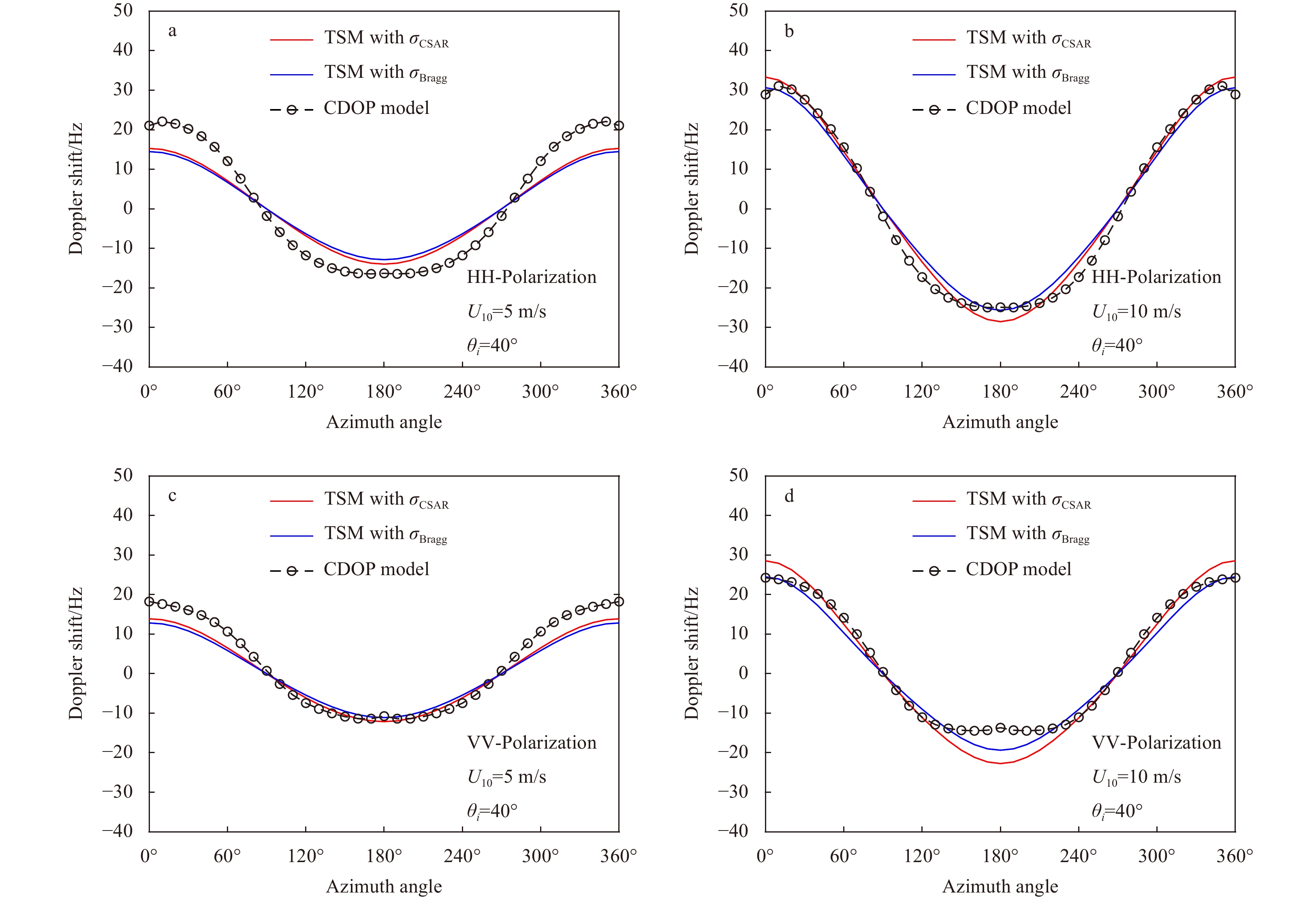
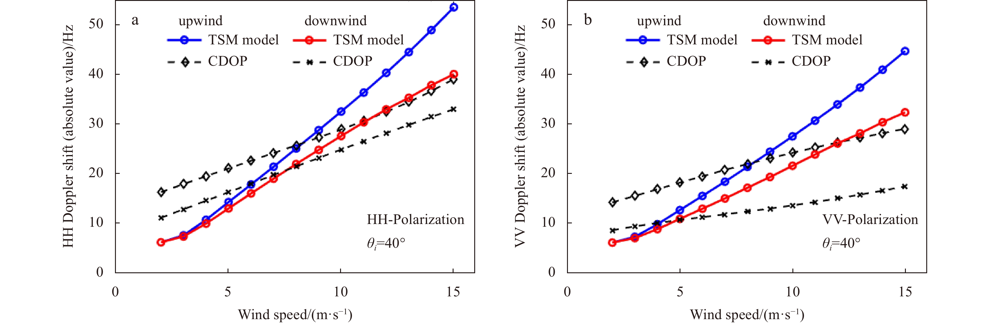
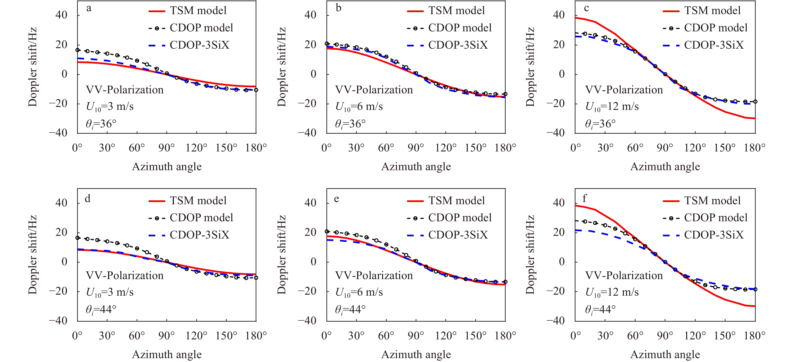
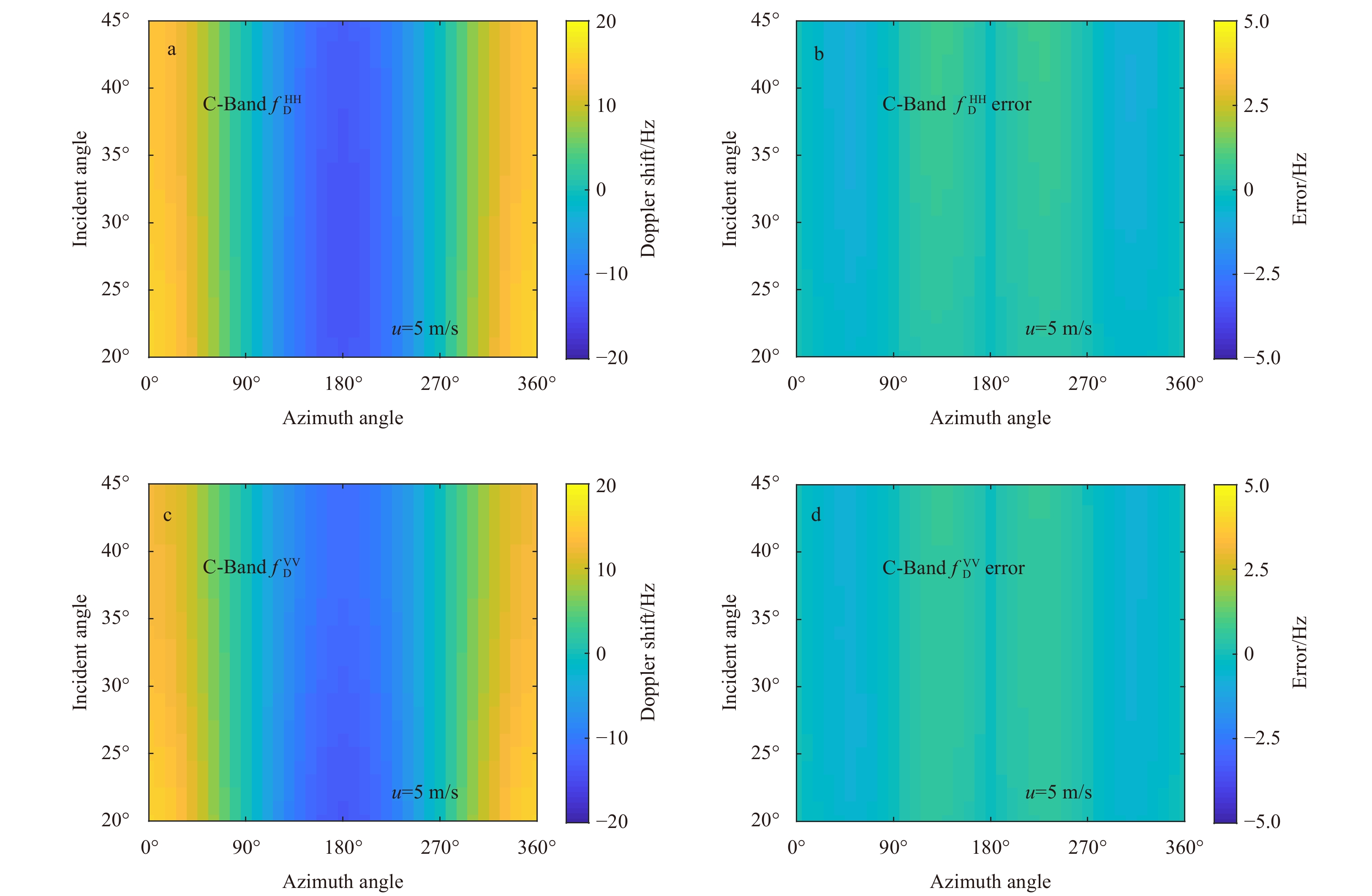
Within the framework of the two-scale scattering model, the Doppler shift of C-band radar return signals from the nonlinear sea surface are numerically evaluated. As an analytical approximation method, the Bragg resonance scattering method cannot accurately describe the backscattering field from sea surface. Therefore, in the two-scale scattering model, more accurate scattering coefficient (the normalized radar cross section, NRCS) evaluated by the C-band dual-polarized (HH/VV) empirical geophysical model function (CSAR model) is employed to replace the traditional Bragg NRCS to weight the Doppler shift. The numerical results indicate that there are obvious differences between the Doppler shift weighted by the CSAR NRCS and that weighted by the traditional Bragg NRCS. The hydrodynamic modulation of the large-scale waves is one of the important factors that affect the difference between the Doppler shift predicted in upwind and downwind directions. If the relaxation rate in the hydrodynamic modulation is set to be the angular frequency of the dominant water waves, the Doppler shift predicted by the numerical method can fit the results of the empirical model (C-band empirical geophysical model function, CDOP) well at moderate wind speed. Under low wind condition, the comparison shows that the empirical CDOP model appears to overestimate the Doppler shift. In order to facilitate the application, at the end of this paper a semi-empirical CSAR-DOP model, which is a polynomial fitting formula, is developed for evaluating the Doppler shift of C-band signals from time varying sea surface.
Within the framework of the two-scale scattering model, the Doppler shift of C-band radar return signals from the nonlinear sea surface are numerically evaluated. As an analytical approximation method, the Bragg resonance scattering method cannot accurately describe the backscattering field from sea surface. Therefore, in the two-scale scattering model, more accurate scattering coefficient (the normalized radar cross section, NRCS) evaluated by the C-band dual-polarized (HH/VV) empirical geophysical model function (CSAR model) is employed to replace the traditional Bragg NRCS to weight the Doppler shift. The numerical results indicate that there are obvious differences between the Doppler shift weighted by the CSAR NRCS and that weighted by the traditional Bragg NRCS. The hydrodynamic modulation of the large-scale waves is one of the important factors that affect the difference between the Doppler shift predicted in upwind and downwind directions. If the relaxation rate in the hydrodynamic modulation is set to be the angular frequency of the dominant water waves, the Doppler shift predicted by the numerical method can fit the results of the empirical model (C-band empirical geophysical model function, CDOP) well at moderate wind speed. Under low wind condition, the comparison shows that the empirical CDOP model appears to overestimate the Doppler shift. In order to facilitate the application, at the end of this paper a semi-empirical CSAR-DOP model, which is a polynomial fitting formula, is developed for evaluating the Doppler shift of C-band signals from time varying sea surface.

2023, 42(6): 112-120.
doi: 10.1007/s13131-022-2129-7
Abstract:
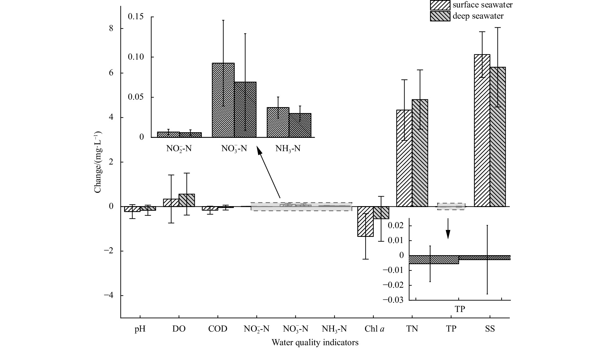
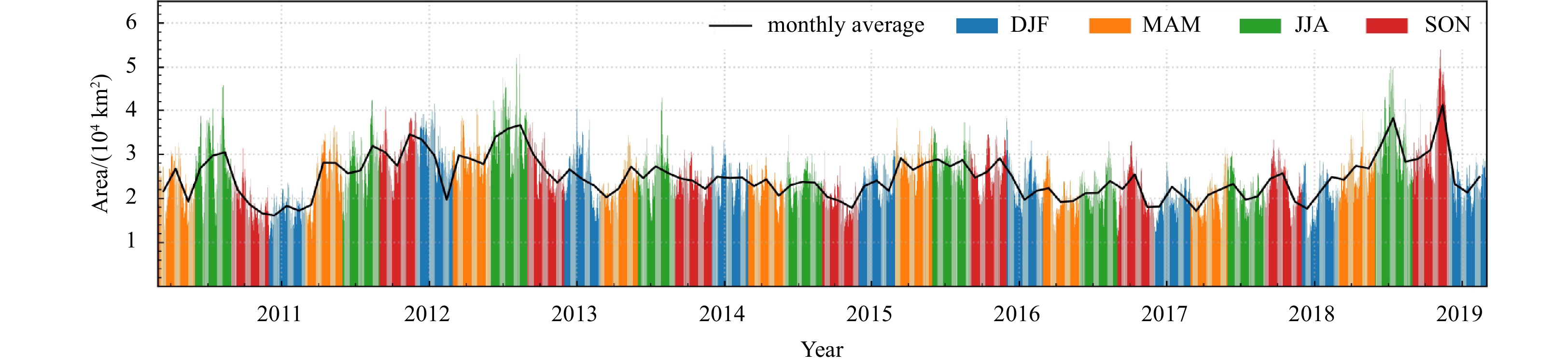
Outbreaks of Ulva prolifera have continued in the South Yellow Sea of China (SYS) since 2007, becoming a serious marine ecological disaster. Large amounts of U. prolifera drift to the coast of the Shandong Peninsula to dissipate under the action of southeast monsoons and ocean surface currents. This causes serious harm to the ecological environment and economic activities of coastal cities. To investigate the impact of U. prolifera dissipation, this study extracted the spatiotemporal distribution of U. prolifera in the SYS from 2012 to 2020 based on the Google Earth Engine. The outbreak cycle of U. prolifera was determined by fitting analysis of outbreak time and coverage area through MATLAB. This study also looked at the effect of U. prolifera dissipation on water quality through field monitoring data. The results showed that the growth curve of the U. prolifera has a significant Gaussian distribution. The U. prolifera dissipates in Haiyang, China, in July and August every year and affects the offshore environment. Water quality parameters of seawater at different depths had significant differences after the U. prolifera dissipation. Changes in pH, chemical oxygen demand, nitrite nitrogen, nitrate nitrogen, ammonia nitrogen, chlorophyll a, total phosphorus, and suspended solids were more significant in surface seawater than in deeper water. Changes in the concentrations of dissolved oxygen and total nitrogen were more significant in the deep seawater (1.63 and 1.1 times higher than those in the surface seawater, respectively). The dissipation of U. prolifera releases a large amount of carbon and nitrogen into the seawater, which provides rich nutrients for phytoplankton and may cause secondary disasters such as red tide. These findings are useful for further understanding the rules of U. prolifera dissipation, as well as preventing and controlling green tide disasters.
Outbreaks of Ulva prolifera have continued in the South Yellow Sea of China (SYS) since 2007, becoming a serious marine ecological disaster. Large amounts of U. prolifera drift to the coast of the Shandong Peninsula to dissipate under the action of southeast monsoons and ocean surface currents. This causes serious harm to the ecological environment and economic activities of coastal cities. To investigate the impact of U. prolifera dissipation, this study extracted the spatiotemporal distribution of U. prolifera in the SYS from 2012 to 2020 based on the Google Earth Engine. The outbreak cycle of U. prolifera was determined by fitting analysis of outbreak time and coverage area through MATLAB. This study also looked at the effect of U. prolifera dissipation on water quality through field monitoring data. The results showed that the growth curve of the U. prolifera has a significant Gaussian distribution. The U. prolifera dissipates in Haiyang, China, in July and August every year and affects the offshore environment. Water quality parameters of seawater at different depths had significant differences after the U. prolifera dissipation. Changes in pH, chemical oxygen demand, nitrite nitrogen, nitrate nitrogen, ammonia nitrogen, chlorophyll a, total phosphorus, and suspended solids were more significant in surface seawater than in deeper water. Changes in the concentrations of dissolved oxygen and total nitrogen were more significant in the deep seawater (1.63 and 1.1 times higher than those in the surface seawater, respectively). The dissipation of U. prolifera releases a large amount of carbon and nitrogen into the seawater, which provides rich nutrients for phytoplankton and may cause secondary disasters such as red tide. These findings are useful for further understanding the rules of U. prolifera dissipation, as well as preventing and controlling green tide disasters.