2024 Vol. 43, No. 1
Display Method:
2024, 43(1)
Abstract:
2024, 43(1): 1-10.
doi: 10.1007/s13131-023-2239-x
Abstract:
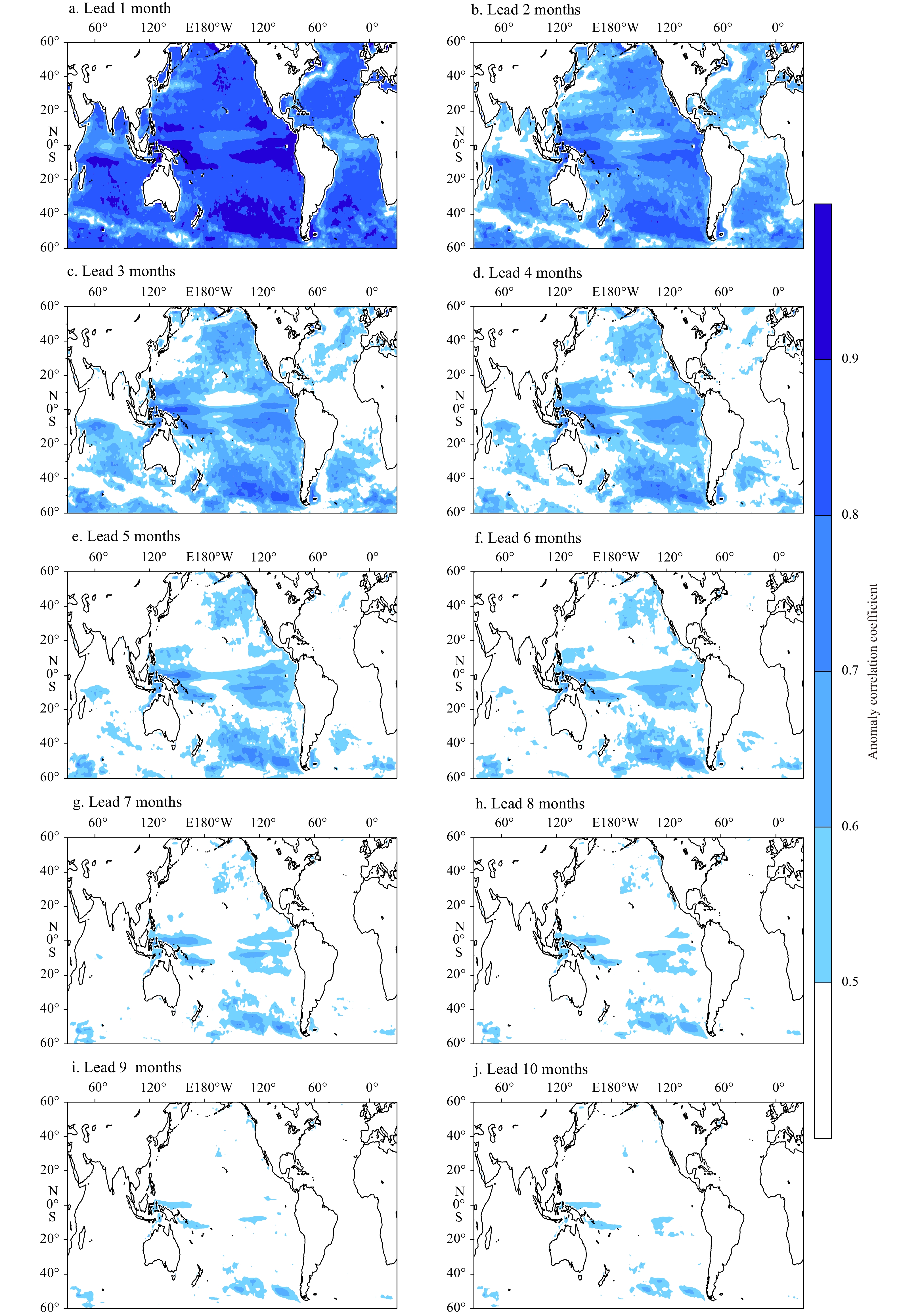
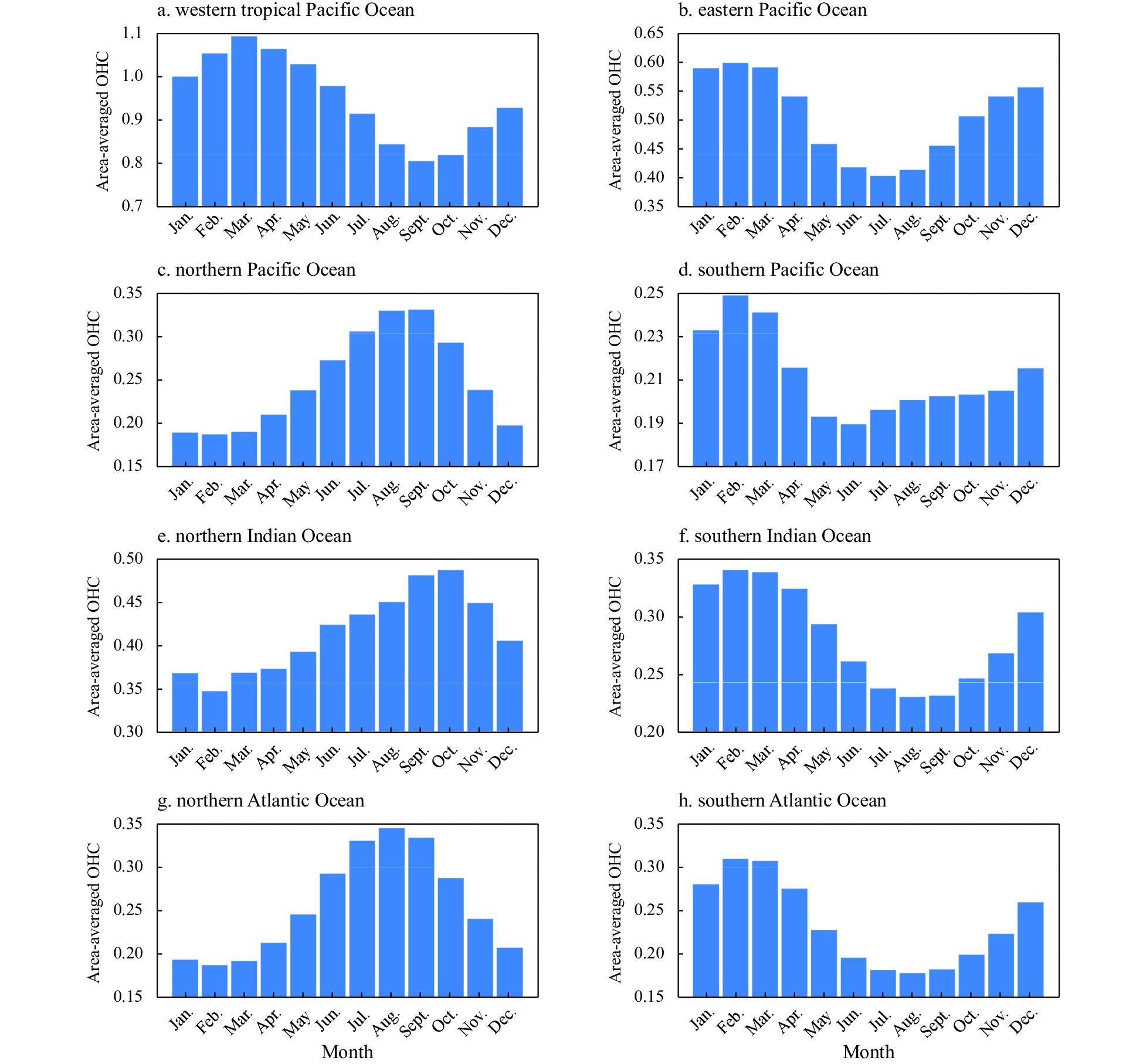
Upper ocean heat content (OHC) has been widely recognized as a crucial precursor to high-impact climate variability, especially for that being indispensable to the long-term memory of the ocean. Assessing the predictability of OHC using state-of-the-art climate models is invaluable for improving and advancing climate forecasts. Recently developed retrospective forecast experiments, based on a Community Earth System Model ensemble prediction system, offer a great opportunity to comprehensively explore OHC predictability. Our results indicate that the skill of actual OHC predictions varies across different oceans and diminishes as the lead time of prediction extends. The spatial distribution of the actual prediction skill closely resembles the corresponding persistence skill, indicating that the persistence of OHC serves as the primary predictive signal for its predictability. The decline in actual prediction skill is more pronounced in the Indian and Atlantic oceans than in the Pacific Ocean, particularly within tropical regions. Additionally, notable seasonal variations in the actual prediction skills across different oceans align well with the phase-locking features of OHC variability. The potential predictability of OHC generally surpasses the actual prediction skill at all lead times, highlighting significant room for improvement in current OHC predictions, especially for the North Indian Ocean and the Atlantic Ocean. Achieving such improvements necessitates a collaborative effort to enhance the quality of ocean observations, develop effective data assimilation methods, and reduce model bias.
Upper ocean heat content (OHC) has been widely recognized as a crucial precursor to high-impact climate variability, especially for that being indispensable to the long-term memory of the ocean. Assessing the predictability of OHC using state-of-the-art climate models is invaluable for improving and advancing climate forecasts. Recently developed retrospective forecast experiments, based on a Community Earth System Model ensemble prediction system, offer a great opportunity to comprehensively explore OHC predictability. Our results indicate that the skill of actual OHC predictions varies across different oceans and diminishes as the lead time of prediction extends. The spatial distribution of the actual prediction skill closely resembles the corresponding persistence skill, indicating that the persistence of OHC serves as the primary predictive signal for its predictability. The decline in actual prediction skill is more pronounced in the Indian and Atlantic oceans than in the Pacific Ocean, particularly within tropical regions. Additionally, notable seasonal variations in the actual prediction skills across different oceans align well with the phase-locking features of OHC variability. The potential predictability of OHC generally surpasses the actual prediction skill at all lead times, highlighting significant room for improvement in current OHC predictions, especially for the North Indian Ocean and the Atlantic Ocean. Achieving such improvements necessitates a collaborative effort to enhance the quality of ocean observations, develop effective data assimilation methods, and reduce model bias.


2024, 43(1): 11-21.
doi: 10.1007/s13131-023-2268-5
Abstract:
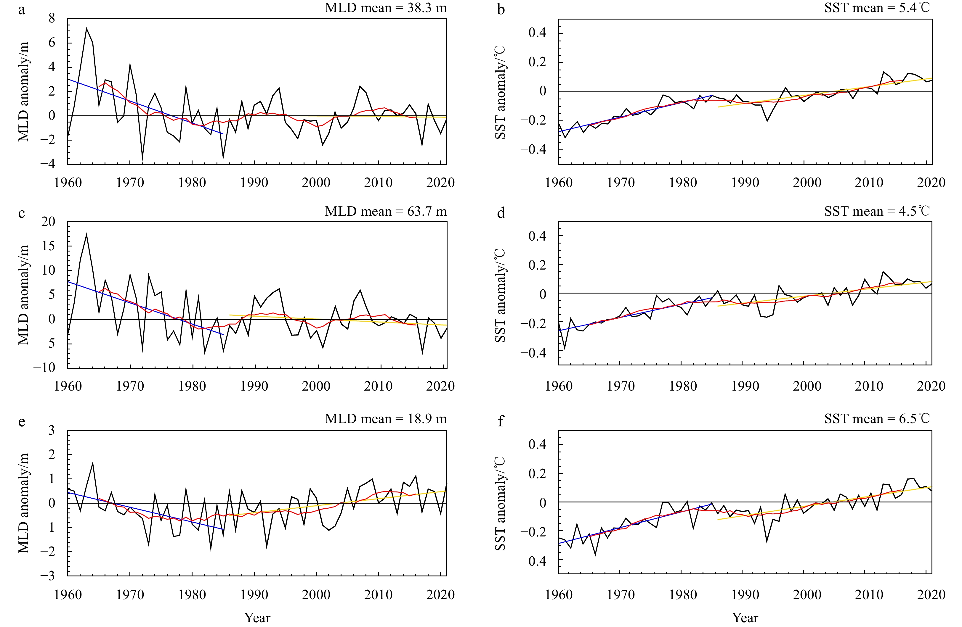
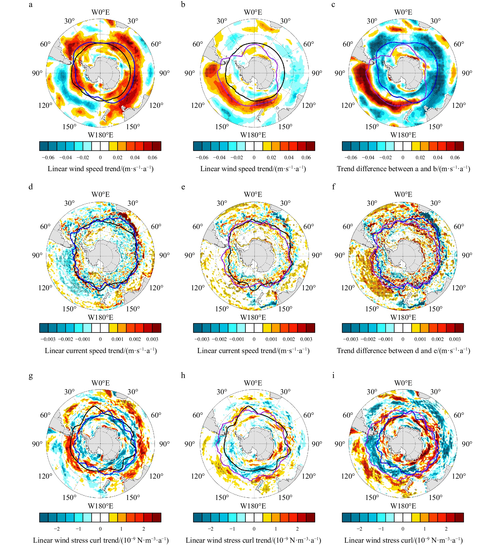
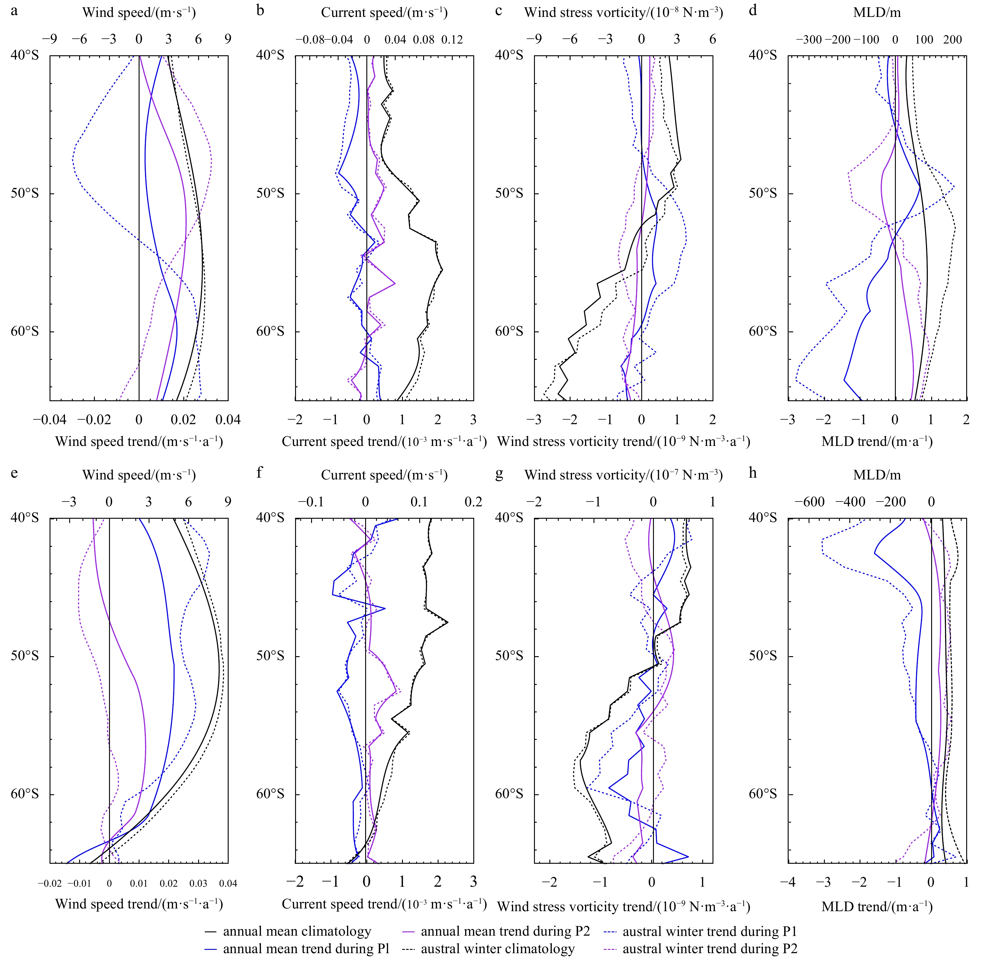
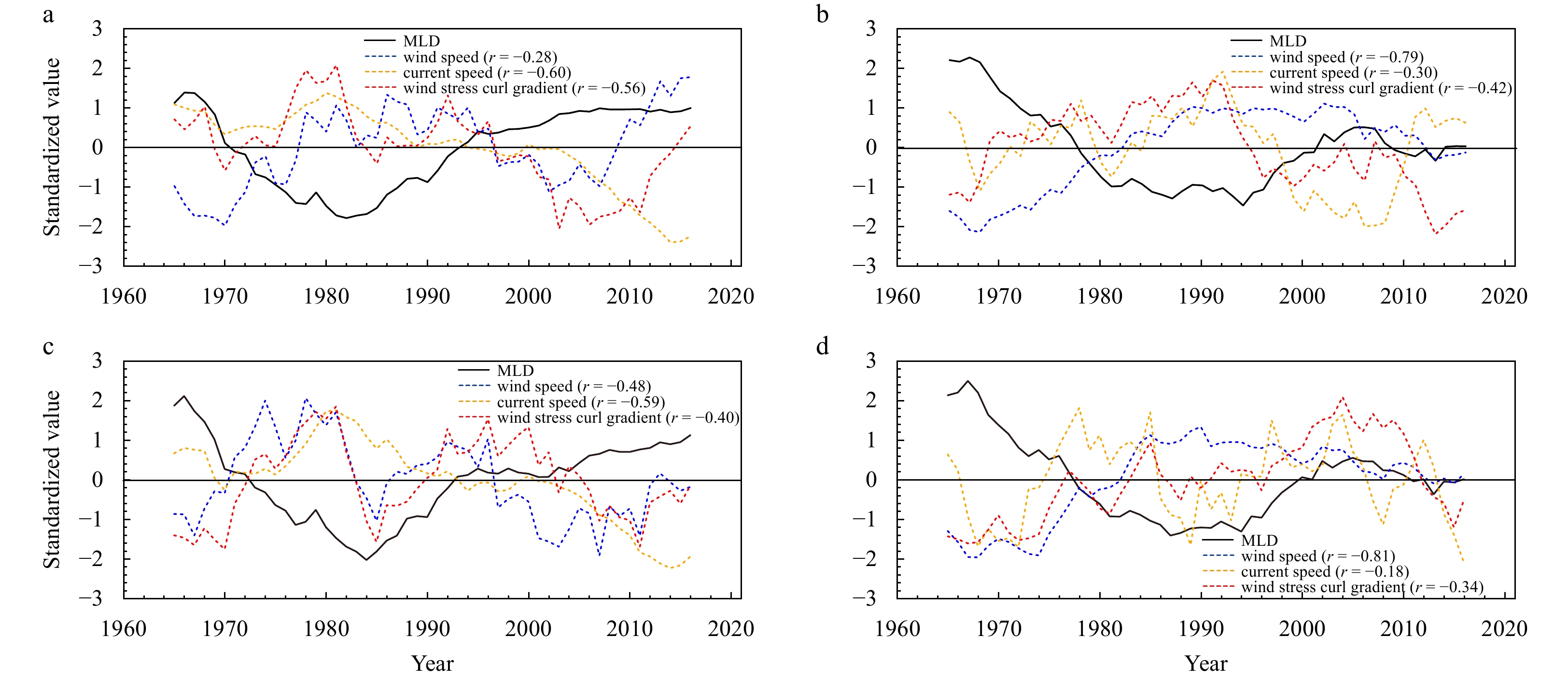
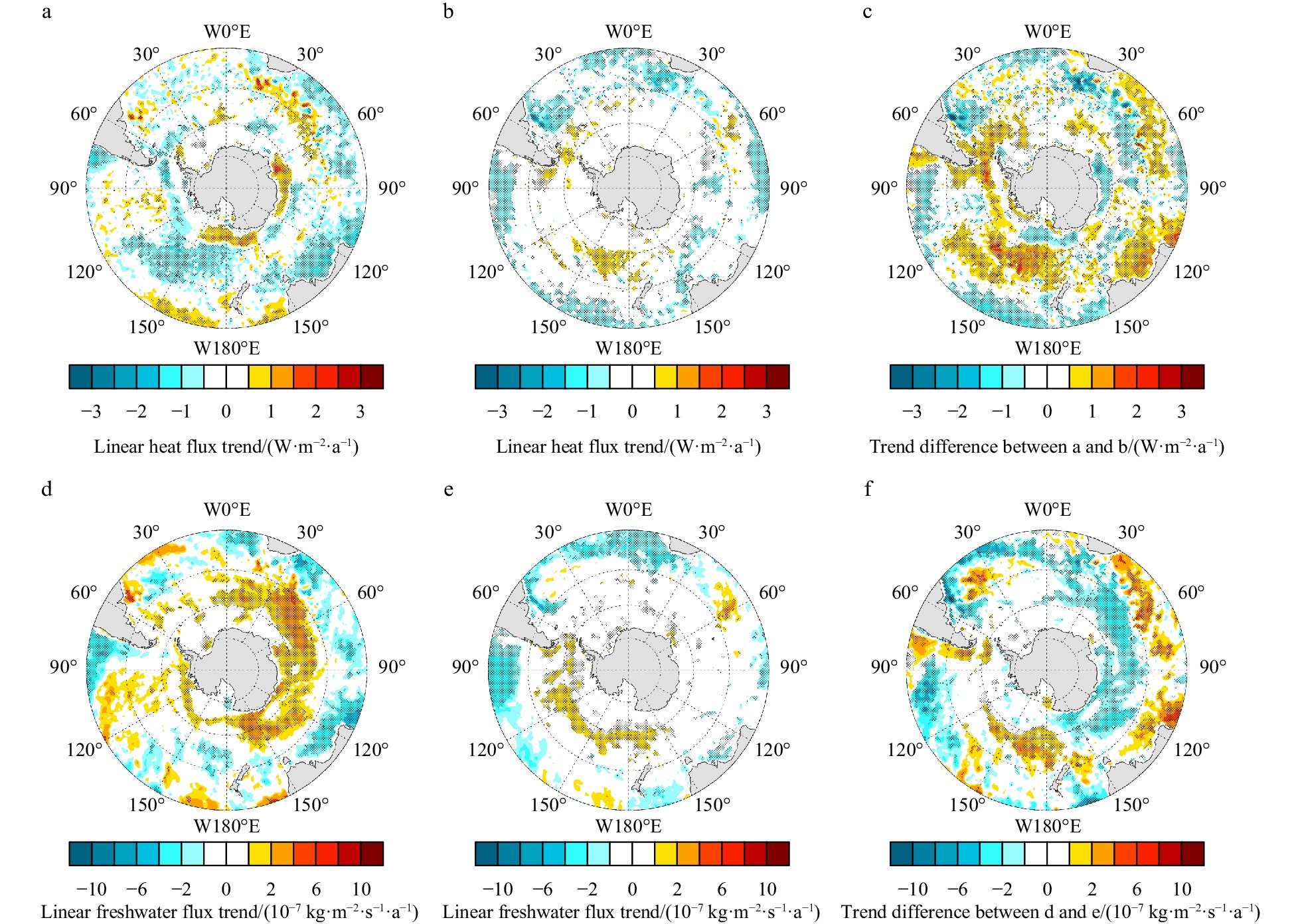
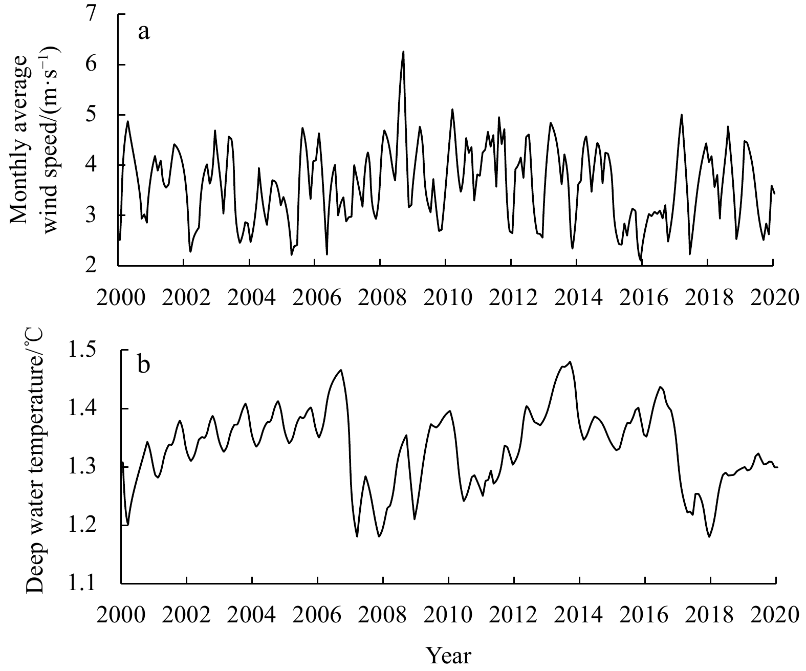
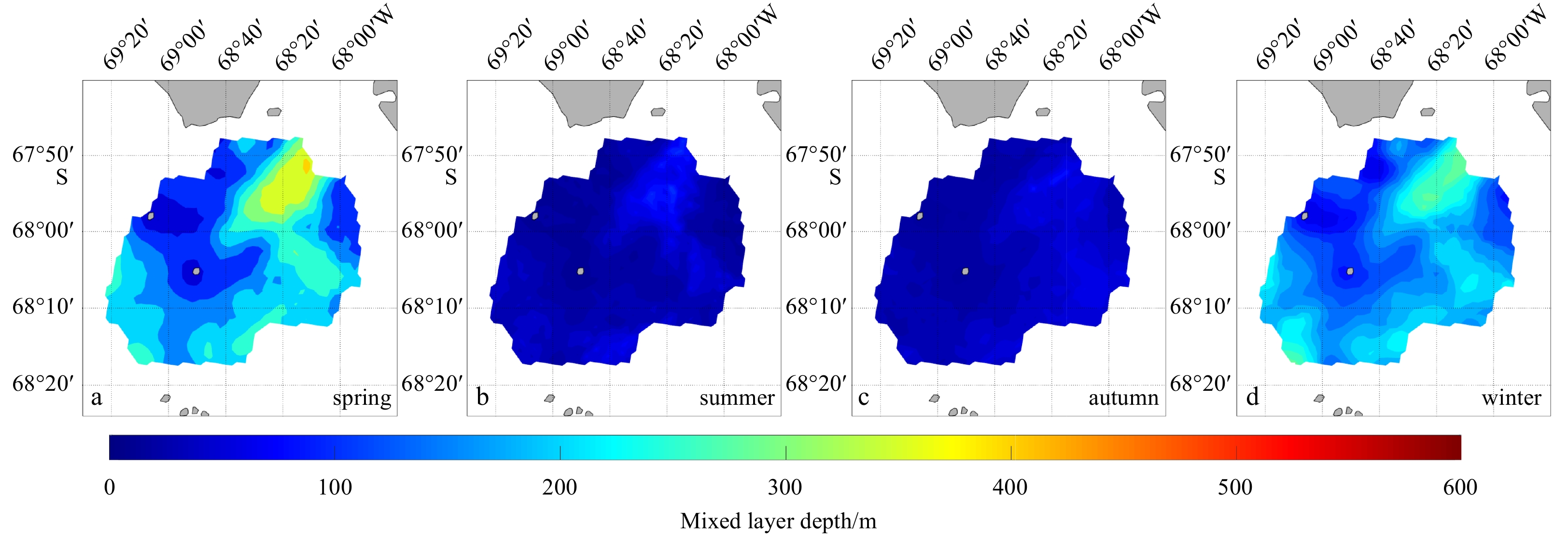
An obvious trend shift in the annual mean and winter mixed layer depth (MLD) in the Antarctic Circumpolar Current (ACC) region was detected during the 1960–2021 period. Shallowing trends stopped in mid-1980s, followed by a period of weak trends. The MLD deepening trend difference between the two periods were mainly distributed in the western areas in the Drake Passage, the areas north to Victoria Land and Wilkes Land, and the central parts of the South Indian sector. The newly formed ocean current shear due to the meridional shift of the ACC flow axis between the two periods is the dominant driver for the MLD trends shift distributed in the western areas in the Drake Passage and the central parts of the South Indian sector. The saltier trends in the regions north to Victoria Land and Wilkes Land could be responsible for the strengthening mixing processes in this region.
An obvious trend shift in the annual mean and winter mixed layer depth (MLD) in the Antarctic Circumpolar Current (ACC) region was detected during the 1960–2021 period. Shallowing trends stopped in mid-1980s, followed by a period of weak trends. The MLD deepening trend difference between the two periods were mainly distributed in the western areas in the Drake Passage, the areas north to Victoria Land and Wilkes Land, and the central parts of the South Indian sector. The newly formed ocean current shear due to the meridional shift of the ACC flow axis between the two periods is the dominant driver for the MLD trends shift distributed in the western areas in the Drake Passage and the central parts of the South Indian sector. The saltier trends in the regions north to Victoria Land and Wilkes Land could be responsible for the strengthening mixing processes in this region.


2024, 43(1): 22-34.
doi: 10.1007/s13131-023-2271-x
Abstract:
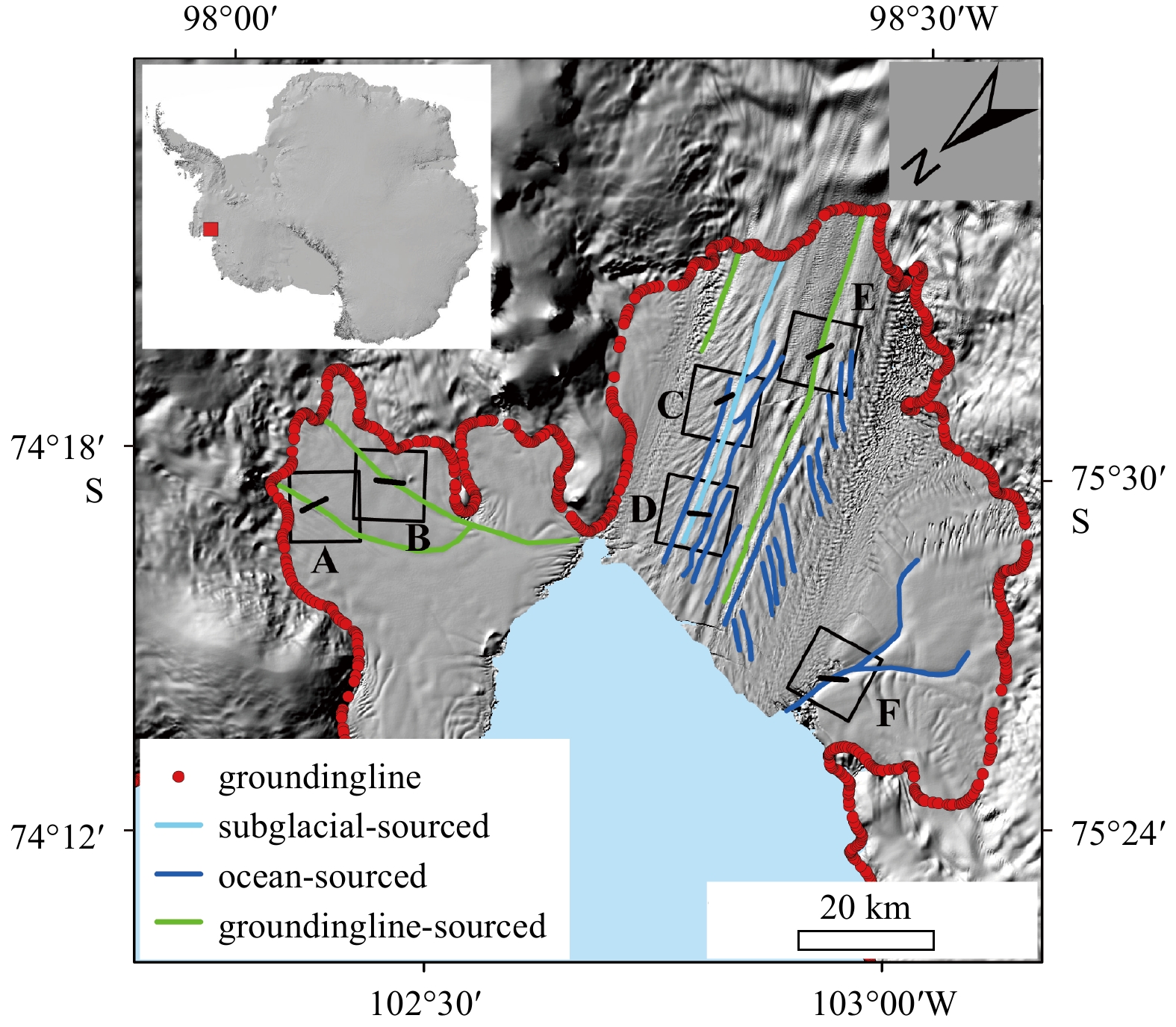
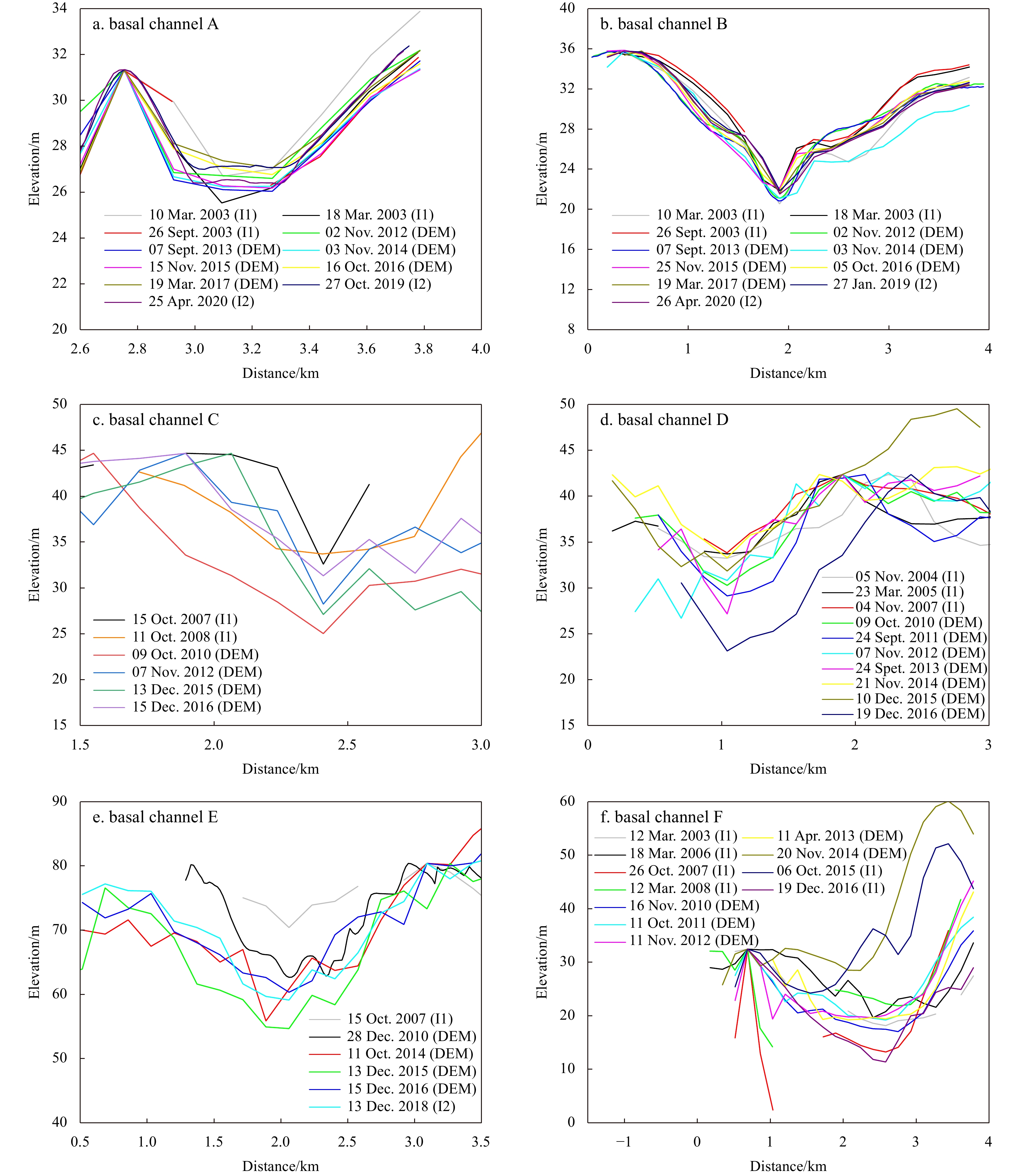
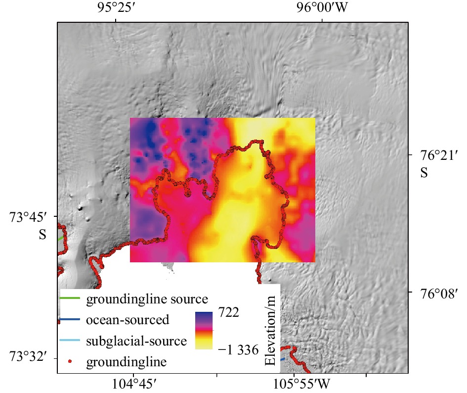
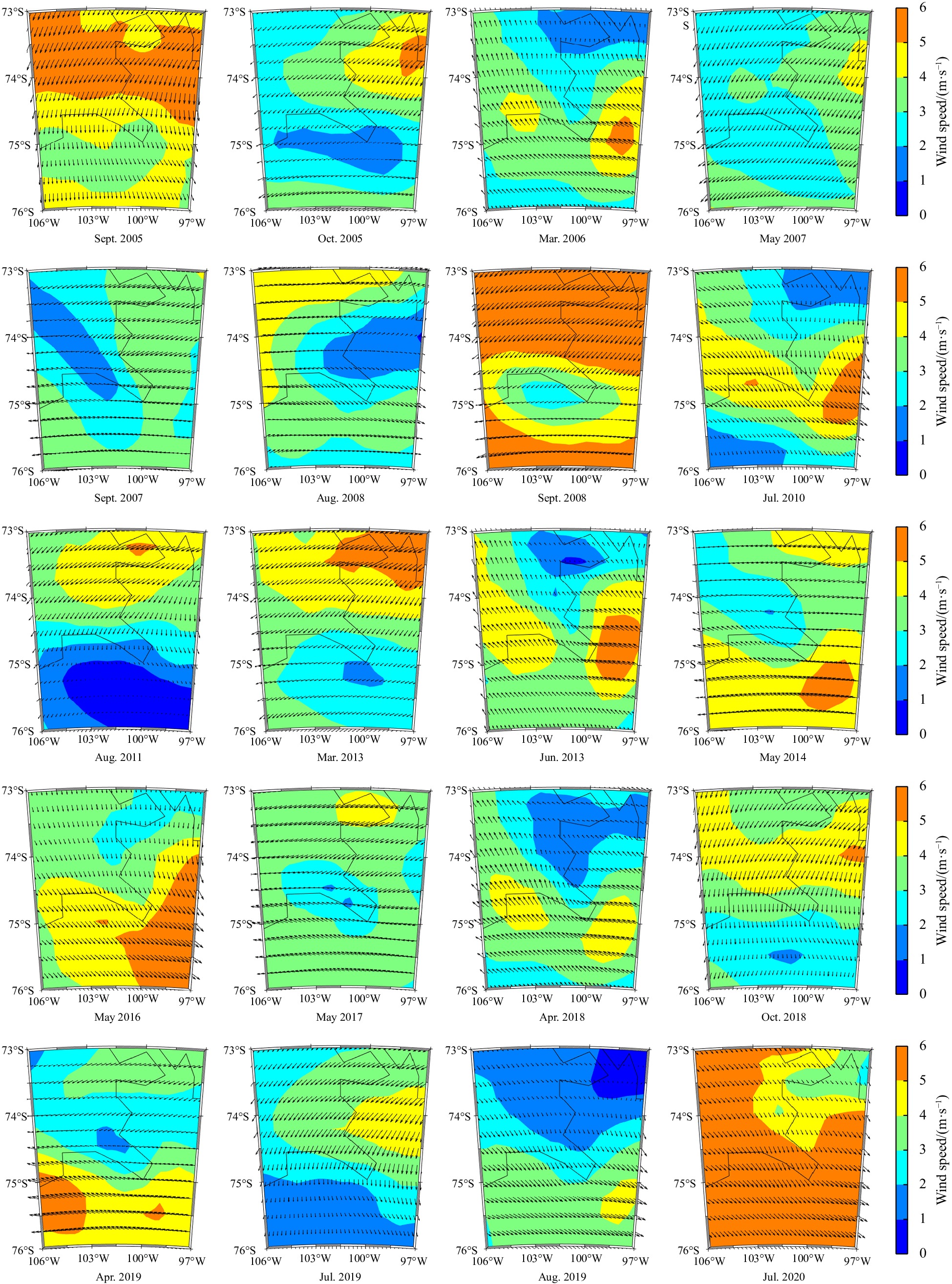
In recent years, there has been a significant acceleration in the thinning, calving and retreat of the Pine Island Ice Shelf (PIIS). The basal channels, results of enhanced basal melting, have the potential to significantly impact the stability of the PIIS. In this study, we used a variety of remote sensing data, including Landsat, REMA DEM, ICESat-1 and ICESat-2 satellite altimetry observations, and IceBridge airborne measurements, to study the spatiotemporal changes in the basal channels from 2003 to 2020 and basal melt rate from 2010 to 2017 of the PIIS under the Eulerian framework. We found that the basal channels are highly developed in the PIIS, with a total length exceeding 450 km. Most of the basal channels are ocean-sourced or groundingline-sourced basal channels, caused by the rapid melting under the ice shelf or near the groundingline. A raised seabed prevented warm water intrusion into the eastern branch of the PIIS, resulting in a lower basal melt rate in that area. In contrast, a deep-sea trough facilitates warm seawater into the mainstream and the western branch of the PIIS, resulting in a higher basal melt rate in the main-stream, and the surface elevation changes above the basal channels of the mainstream and western branch are more significant. The El Niño event in 2015–2016 possibly slowed down the basal melting of the PIIS by modulating wind field, surface sea temperature and depth seawater temperature. Ocean and atmospheric changes were driven by El Niño, which can further explain and confirm the changes in the basal melting of the PIIS.
In recent years, there has been a significant acceleration in the thinning, calving and retreat of the Pine Island Ice Shelf (PIIS). The basal channels, results of enhanced basal melting, have the potential to significantly impact the stability of the PIIS. In this study, we used a variety of remote sensing data, including Landsat, REMA DEM, ICESat-1 and ICESat-2 satellite altimetry observations, and IceBridge airborne measurements, to study the spatiotemporal changes in the basal channels from 2003 to 2020 and basal melt rate from 2010 to 2017 of the PIIS under the Eulerian framework. We found that the basal channels are highly developed in the PIIS, with a total length exceeding 450 km. Most of the basal channels are ocean-sourced or groundingline-sourced basal channels, caused by the rapid melting under the ice shelf or near the groundingline. A raised seabed prevented warm water intrusion into the eastern branch of the PIIS, resulting in a lower basal melt rate in that area. In contrast, a deep-sea trough facilitates warm seawater into the mainstream and the western branch of the PIIS, resulting in a higher basal melt rate in the main-stream, and the surface elevation changes above the basal channels of the mainstream and western branch are more significant. The El Niño event in 2015–2016 possibly slowed down the basal melting of the PIIS by modulating wind field, surface sea temperature and depth seawater temperature. Ocean and atmospheric changes were driven by El Niño, which can further explain and confirm the changes in the basal melting of the PIIS.


2024, 43(1): 35-47.
doi: 10.1007/s13131-023-2201-y
Abstract:
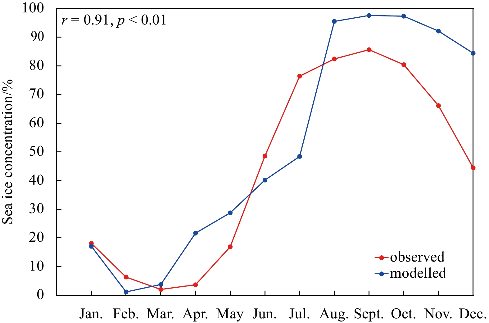
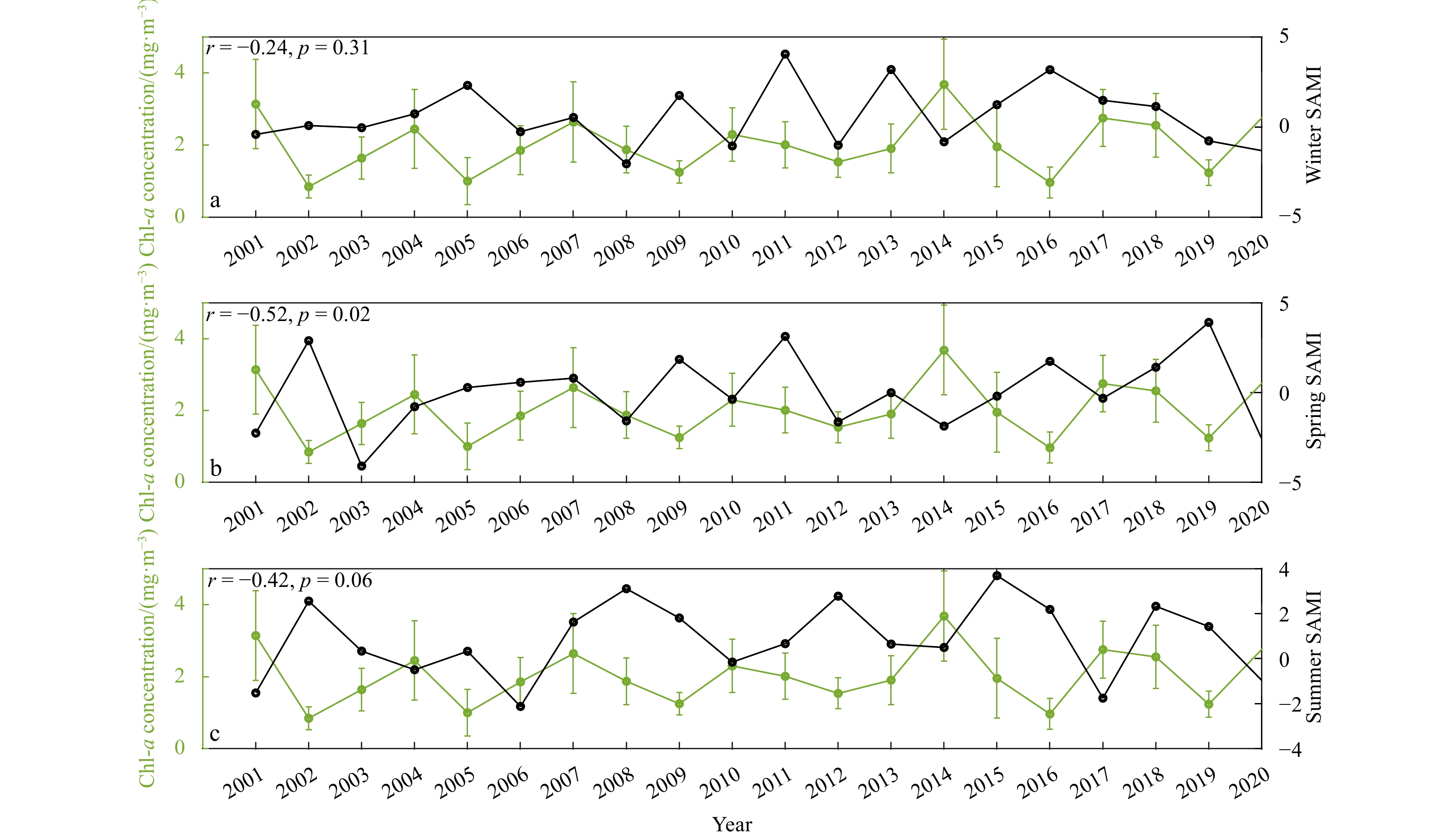
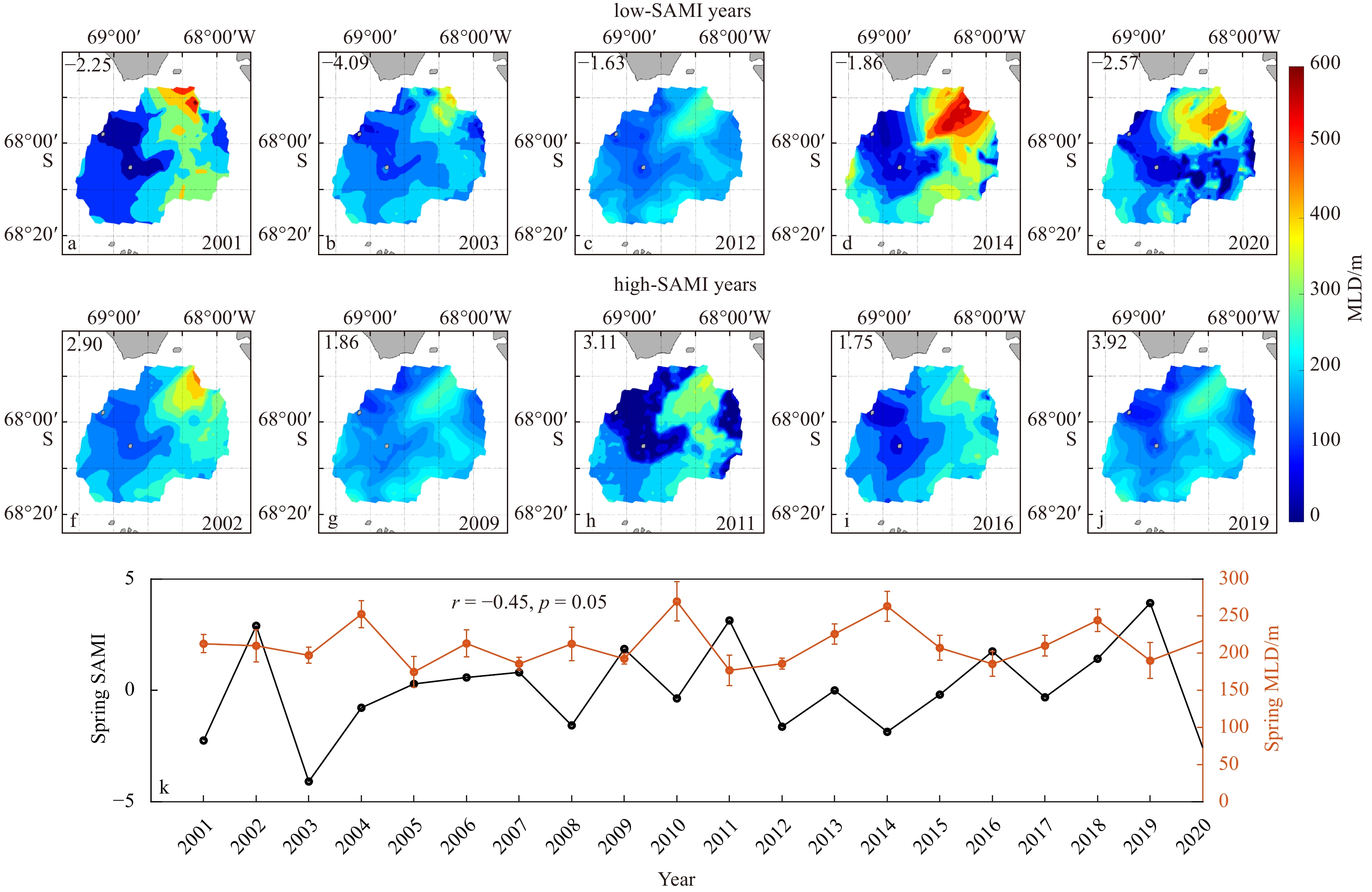
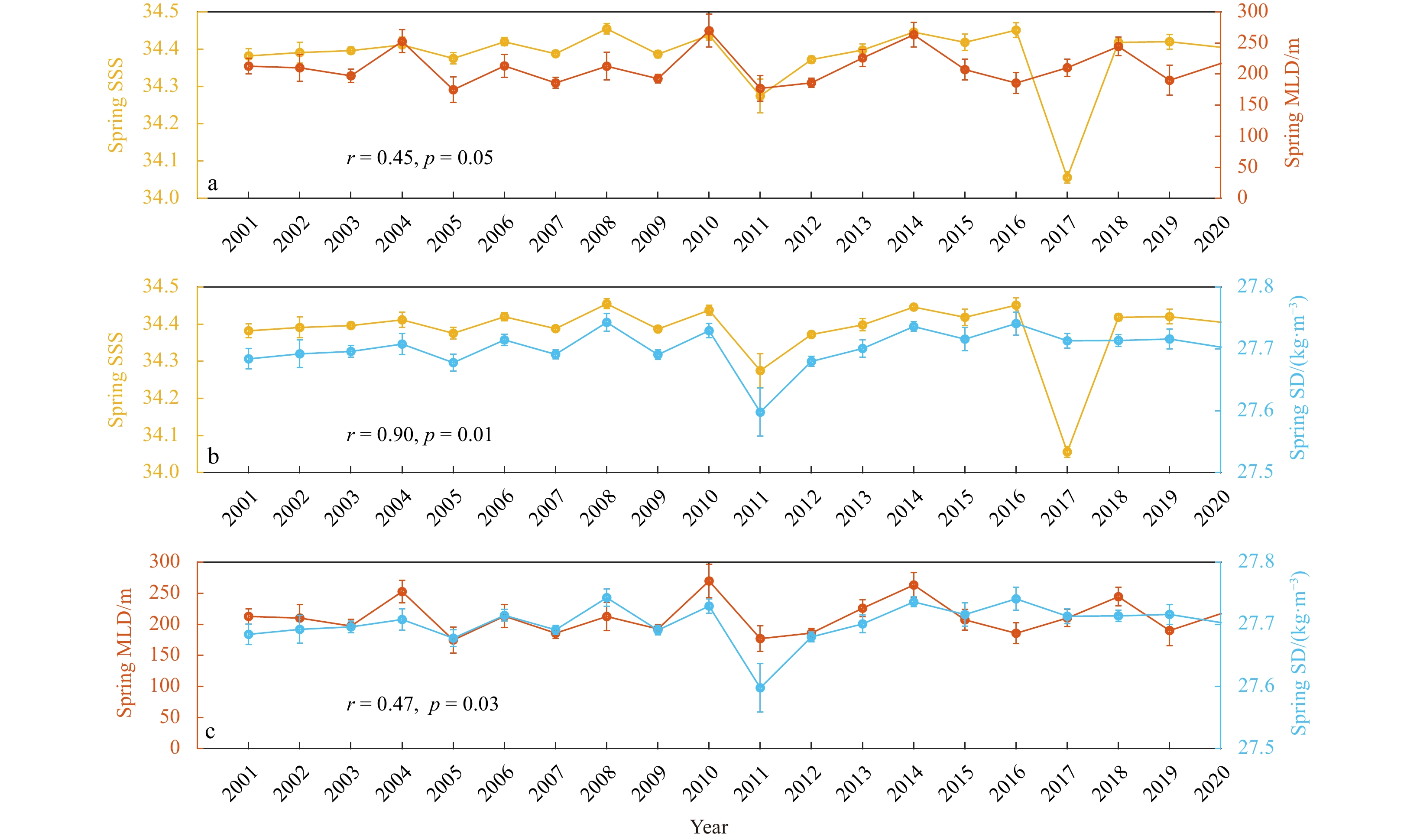
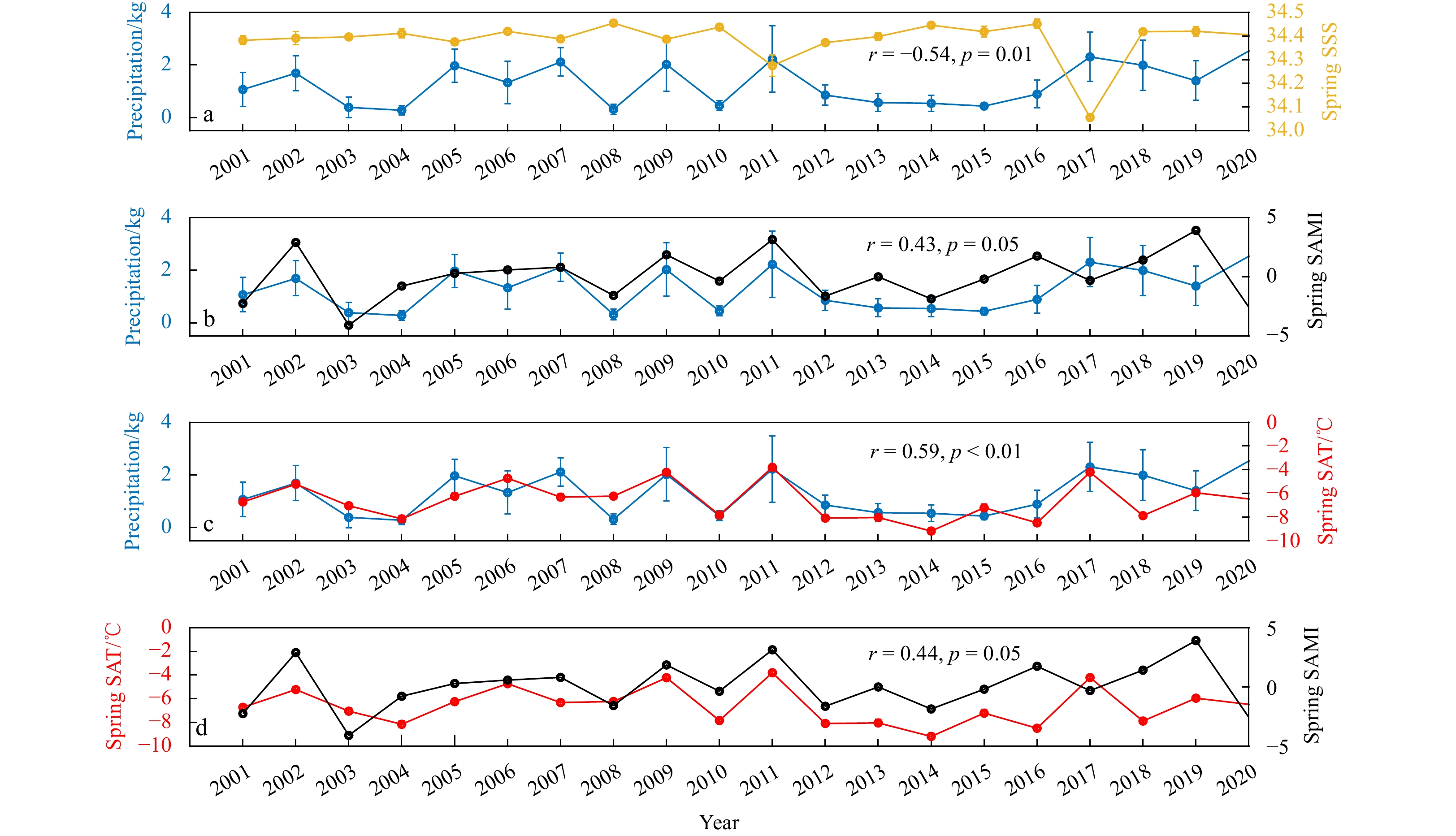
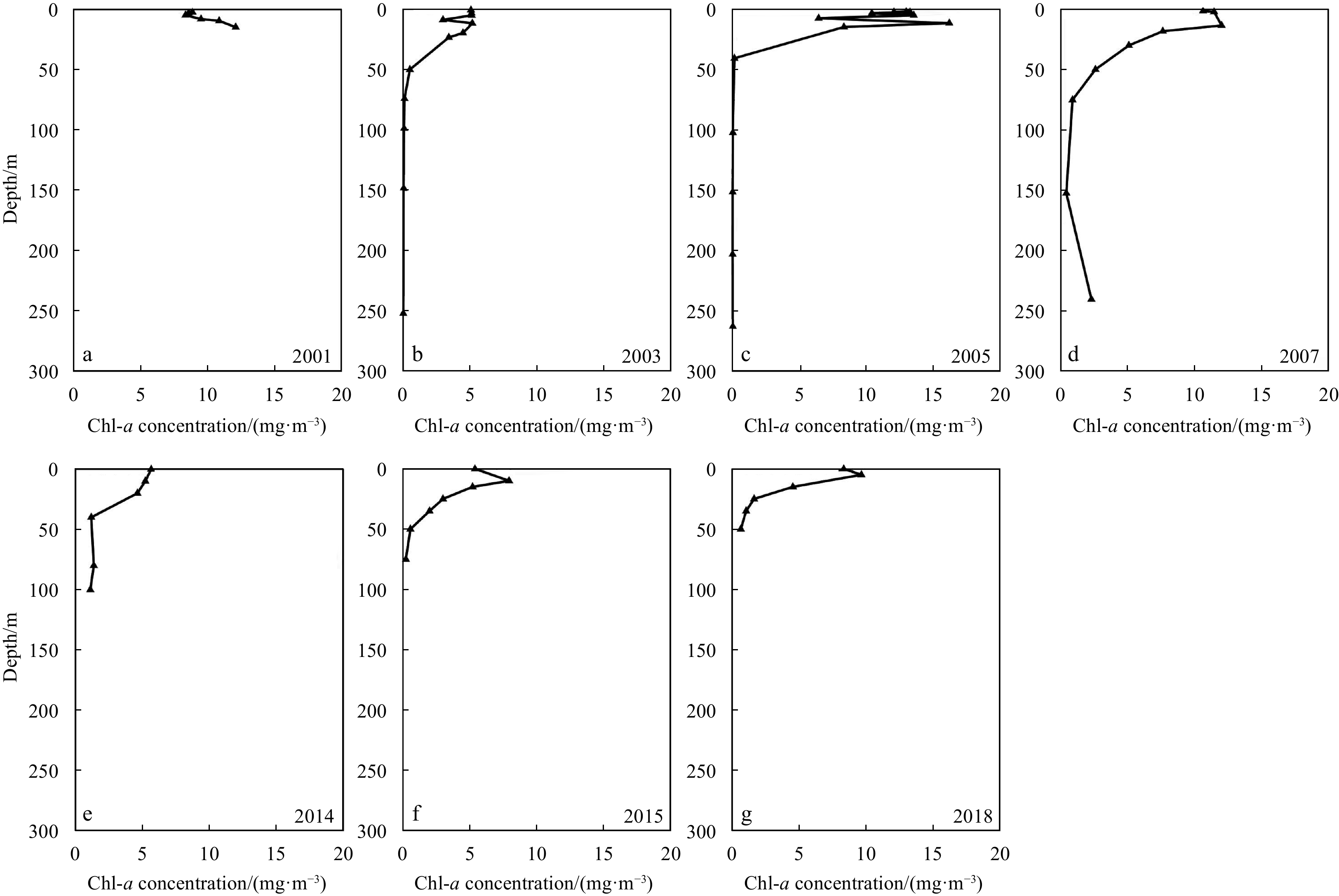
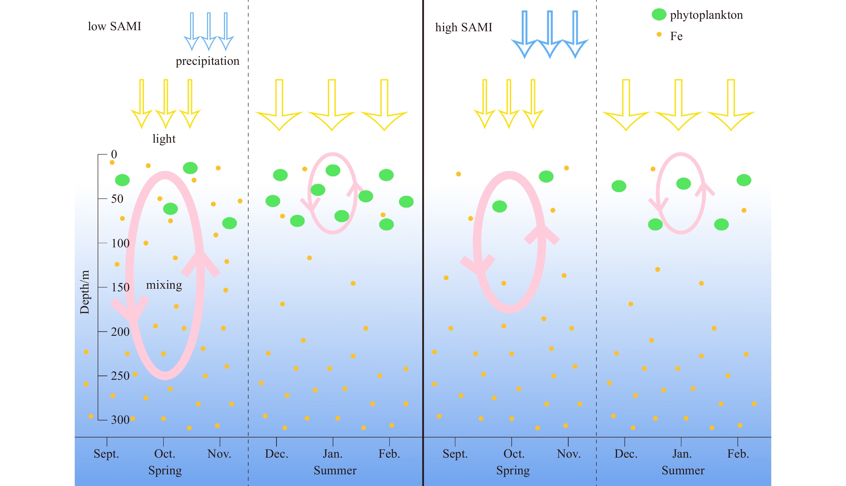
Antarctic coastal polynyas are biological hotspots in the Southern Ocean that support the abundance of high-trophic-level predators and are important for carbon cycling in the high-latitude oceans. In this study, we examined the interannual variation of summertime phytoplankton biomass in the Marguerite Bay polynya (MBP) in the western Antarctic Peninsula area, and linked such variability to the Southern Annular Mode (SAM) that dominated the southern hemisphere extratropical climate variability. Combining satellite data, atmosphere reanalysis products and numerical simulations, we found that the interannual variation of summer chlorophyll-a (Chl-a) concentration in the MBP is significantly and negatively correlated with the spring SAM index, and weakly correlated with the summer SAM index. The negative relation between summer Chl-a and spring SAM is due to weaker spring vertical mixing under a more positive SAM condition, which would inhibit the supply of iron from deep layers into the surface euphotic layer. The negative relation between spring mixing and spring SAM results from greater precipitation rate over the MBP region in positive SAM phase, which leads to lower salinity in the ocean surface layer. The coupled physical-biological mechanisms between SAM and phytoplankton biomass revealed in this study is important for us to predict the future variations of phytoplankton biomasses in Antarctic polynyas under climate change.
Antarctic coastal polynyas are biological hotspots in the Southern Ocean that support the abundance of high-trophic-level predators and are important for carbon cycling in the high-latitude oceans. In this study, we examined the interannual variation of summertime phytoplankton biomass in the Marguerite Bay polynya (MBP) in the western Antarctic Peninsula area, and linked such variability to the Southern Annular Mode (SAM) that dominated the southern hemisphere extratropical climate variability. Combining satellite data, atmosphere reanalysis products and numerical simulations, we found that the interannual variation of summer chlorophyll-a (Chl-a) concentration in the MBP is significantly and negatively correlated with the spring SAM index, and weakly correlated with the summer SAM index. The negative relation between summer Chl-a and spring SAM is due to weaker spring vertical mixing under a more positive SAM condition, which would inhibit the supply of iron from deep layers into the surface euphotic layer. The negative relation between spring mixing and spring SAM results from greater precipitation rate over the MBP region in positive SAM phase, which leads to lower salinity in the ocean surface layer. The coupled physical-biological mechanisms between SAM and phytoplankton biomass revealed in this study is important for us to predict the future variations of phytoplankton biomasses in Antarctic polynyas under climate change.


2024, 43(1): 48-58.
doi: 10.1007/s13131-023-2278-3
Abstract:
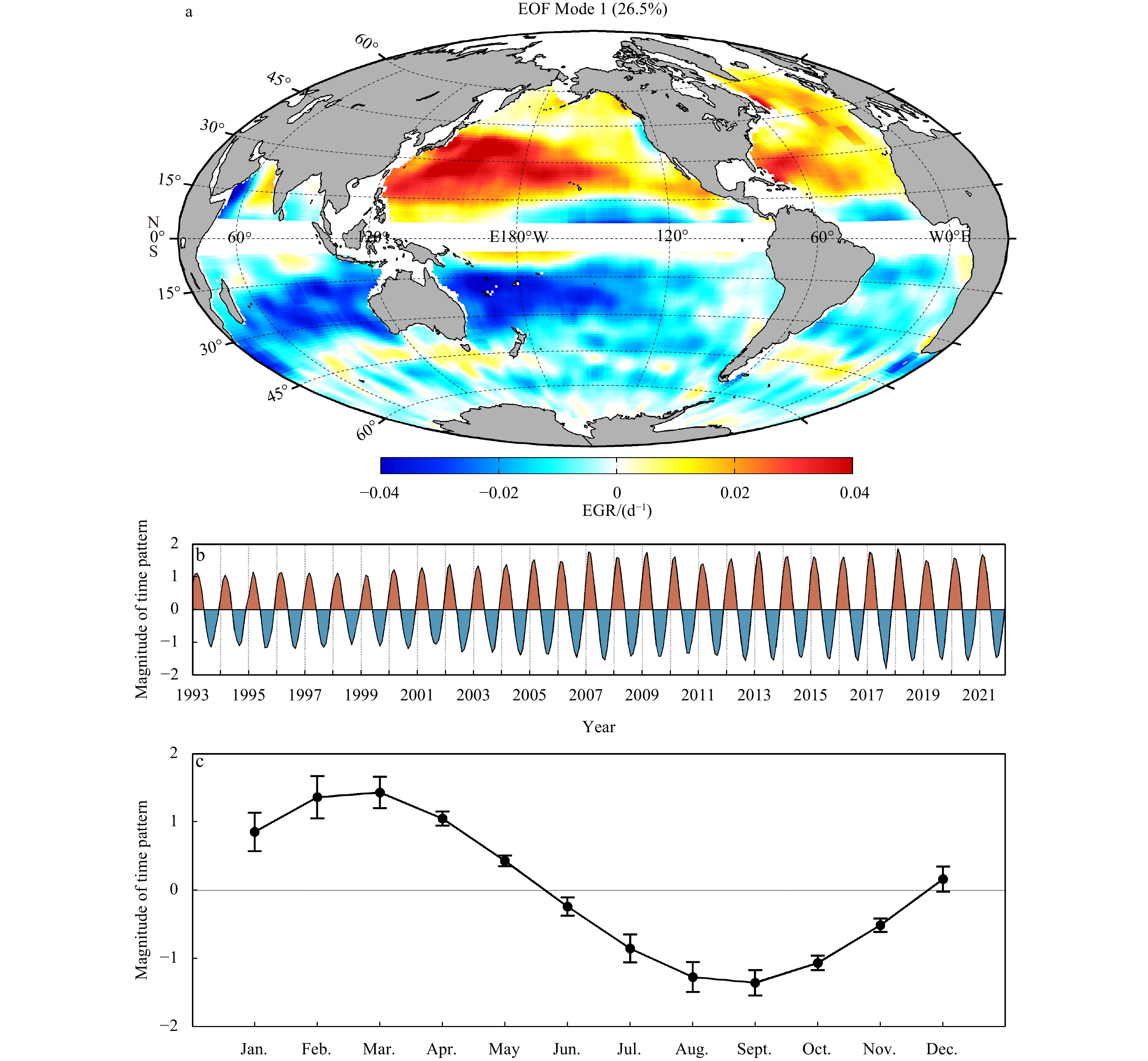
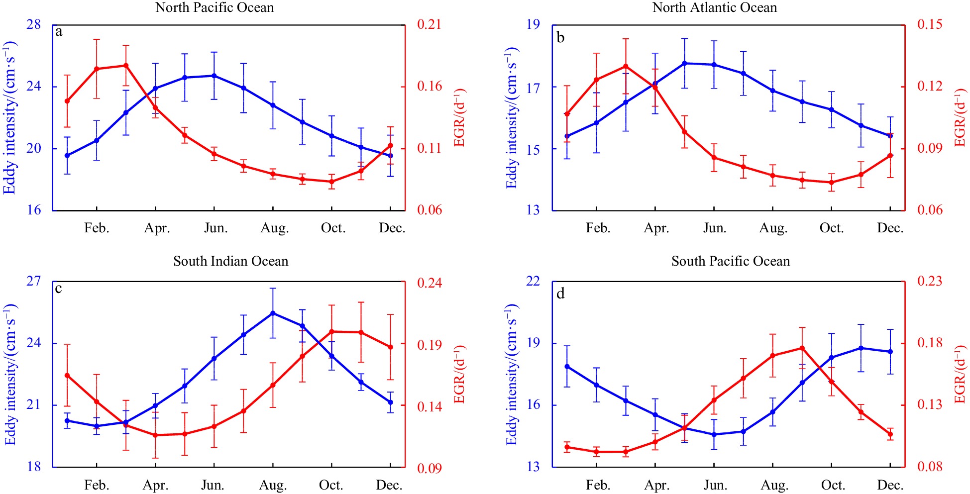
Mesoscale eddies are a prominent oceanic phenomenon that plays an important role in oceanic mass transport and energy conversion. Characterizing by rotational speed, the eddy intensity is one of the most fundamental properties of an eddy. However, the seasonal spatiotemporal variation in eddy intensity has not been examined from a global ocean perspective. In this study, we unveil the seasonal spatiotemporal characteristics of eddy intensity in the global ocean by using the latest satellite-altimetry-derived eddy trajectory data set. The results suggest that the eddy intensity has a distinct seasonal variation, reaching a peak in spring while attaining a minimum in autumn in the Northern Hemisphere and the opposite in the Southern Hemisphere. The seasonal variation of eddy intensity is more intense in the tropical-subtropical transition zones within latitudinal bands between 15° and 30° in the western Pacific Ocean, the northwestern Atlantic Ocean, and the eastern Indian Ocean because baroclinic instability in these areas changes sharply. Further analysis found that the seasonal variation of baroclinic instability precedes the eddy intensity by a phase of 2–3 months due to the initial perturbations needing time to grow into mesoscale eddies.
Mesoscale eddies are a prominent oceanic phenomenon that plays an important role in oceanic mass transport and energy conversion. Characterizing by rotational speed, the eddy intensity is one of the most fundamental properties of an eddy. However, the seasonal spatiotemporal variation in eddy intensity has not been examined from a global ocean perspective. In this study, we unveil the seasonal spatiotemporal characteristics of eddy intensity in the global ocean by using the latest satellite-altimetry-derived eddy trajectory data set. The results suggest that the eddy intensity has a distinct seasonal variation, reaching a peak in spring while attaining a minimum in autumn in the Northern Hemisphere and the opposite in the Southern Hemisphere. The seasonal variation of eddy intensity is more intense in the tropical-subtropical transition zones within latitudinal bands between 15° and 30° in the western Pacific Ocean, the northwestern Atlantic Ocean, and the eastern Indian Ocean because baroclinic instability in these areas changes sharply. Further analysis found that the seasonal variation of baroclinic instability precedes the eddy intensity by a phase of 2–3 months due to the initial perturbations needing time to grow into mesoscale eddies.


2024, 43(1): 59-69.
doi: 10.1007/s13131-023-2150-5
Abstract:
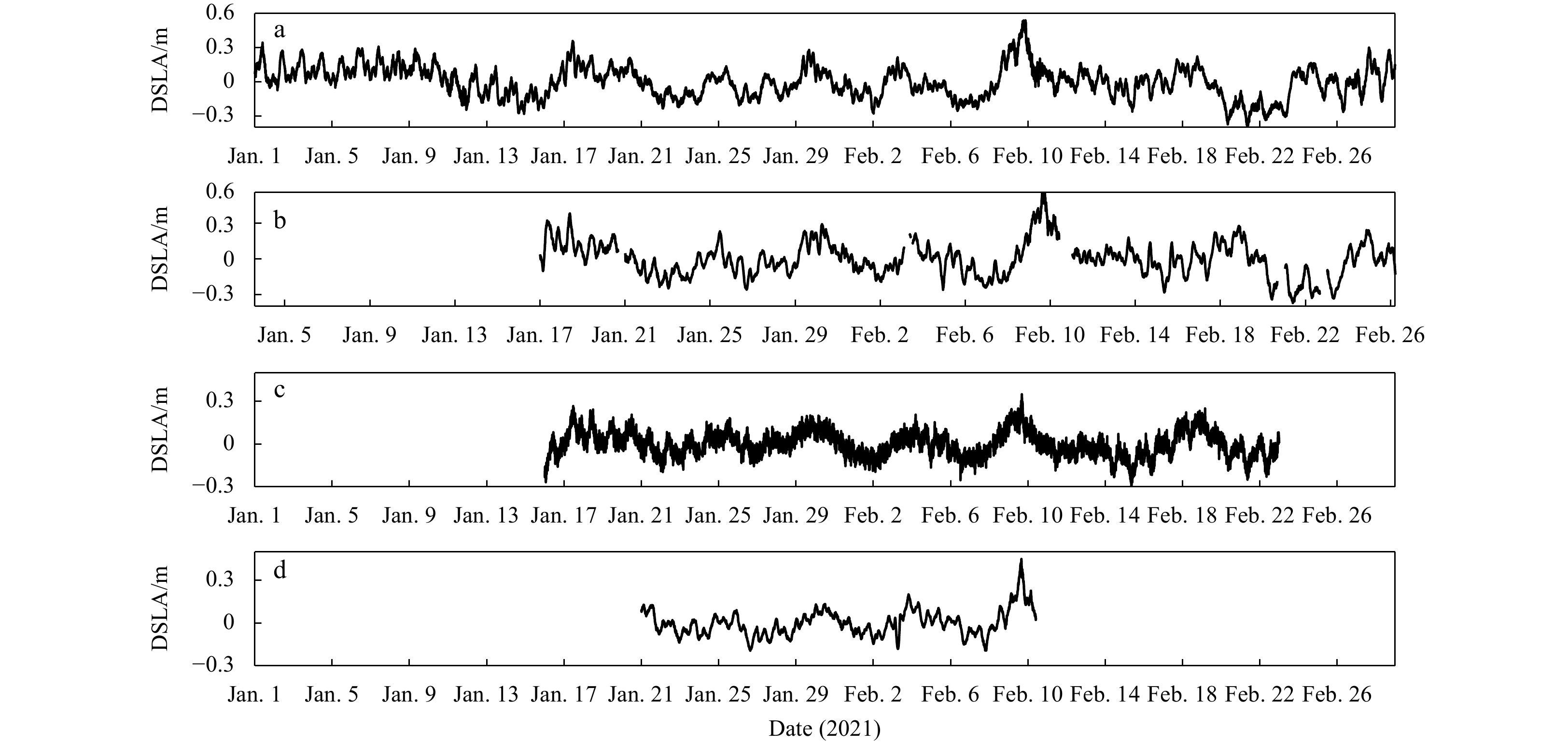
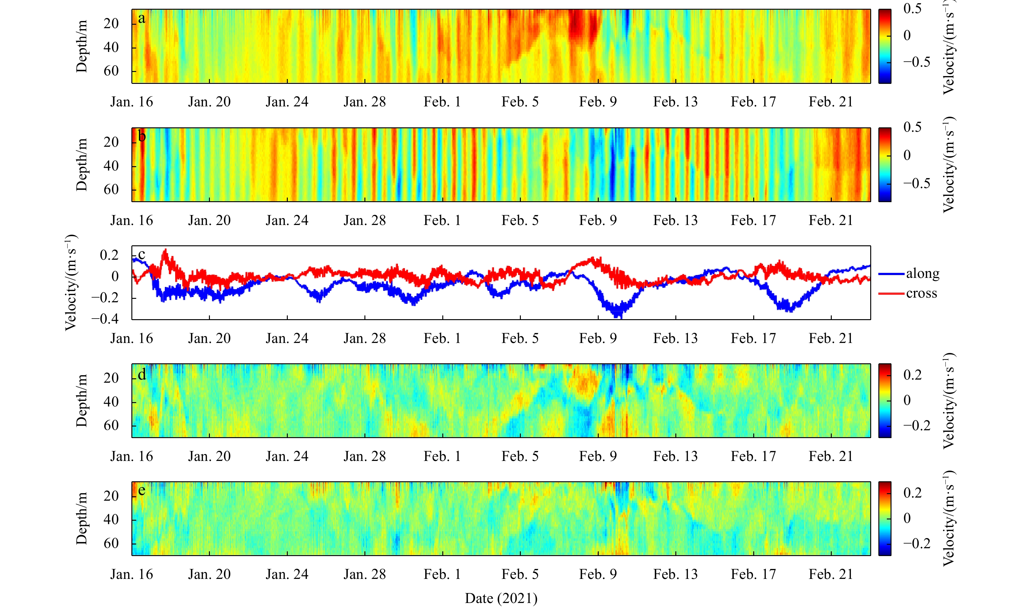
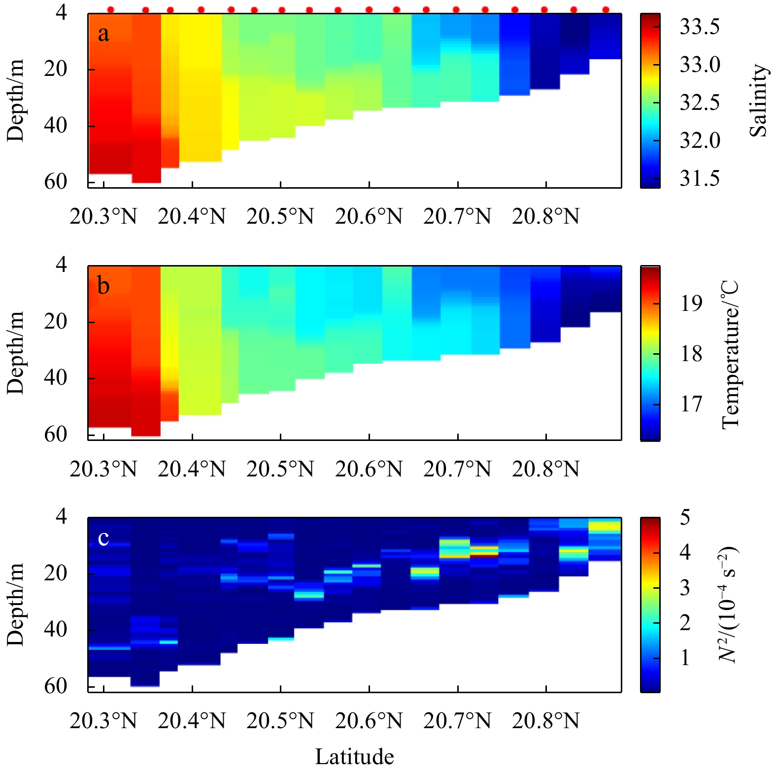
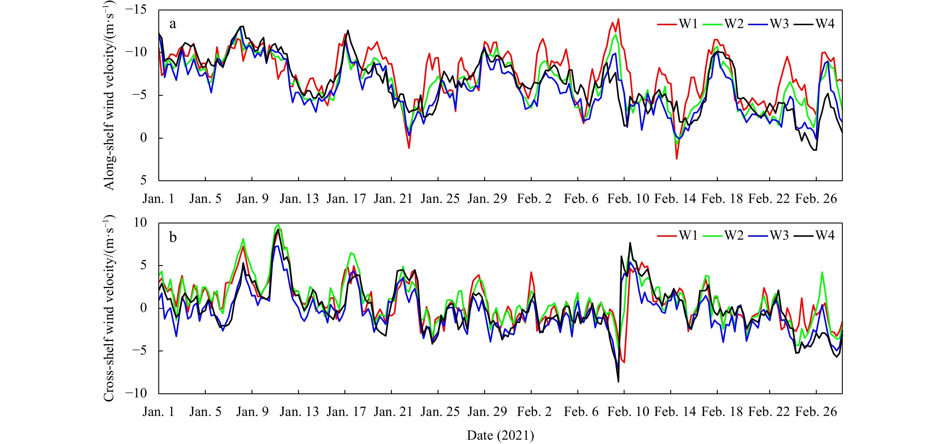
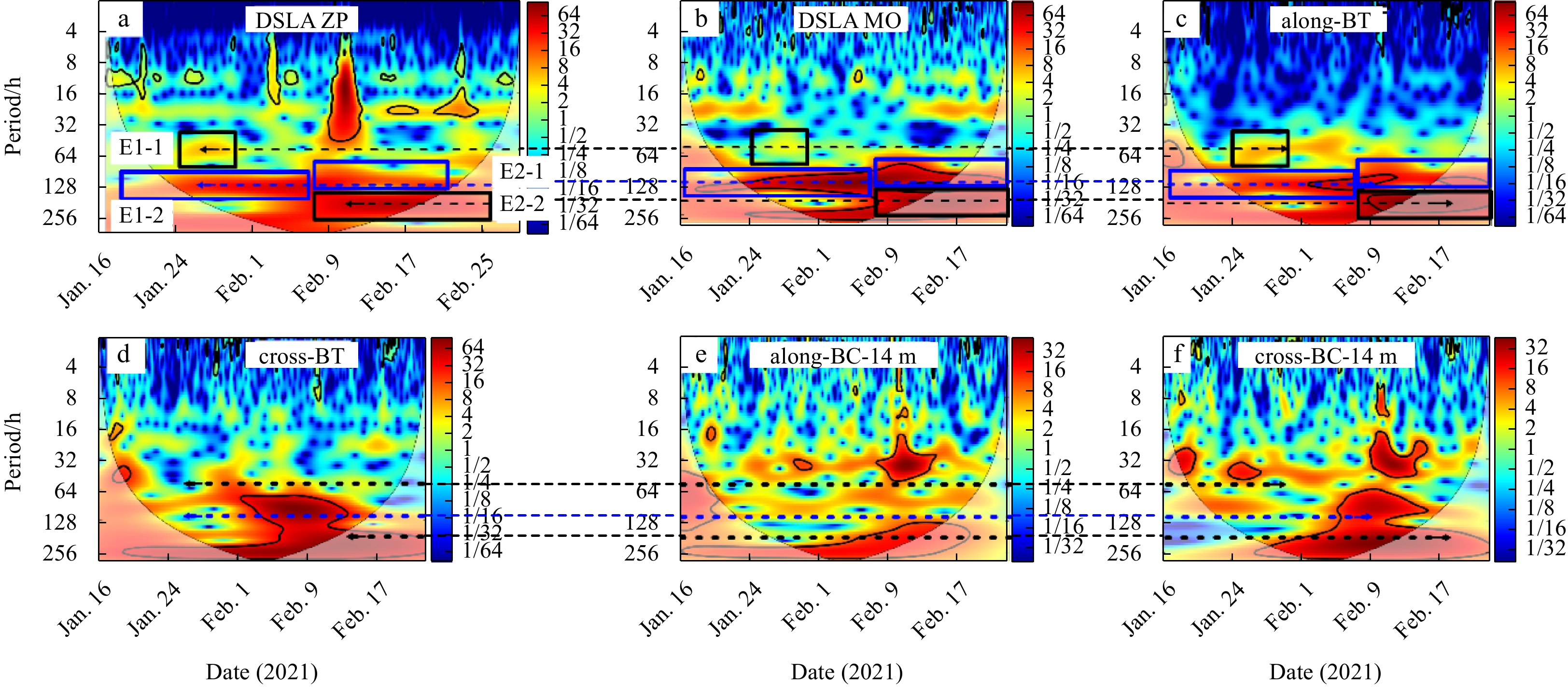
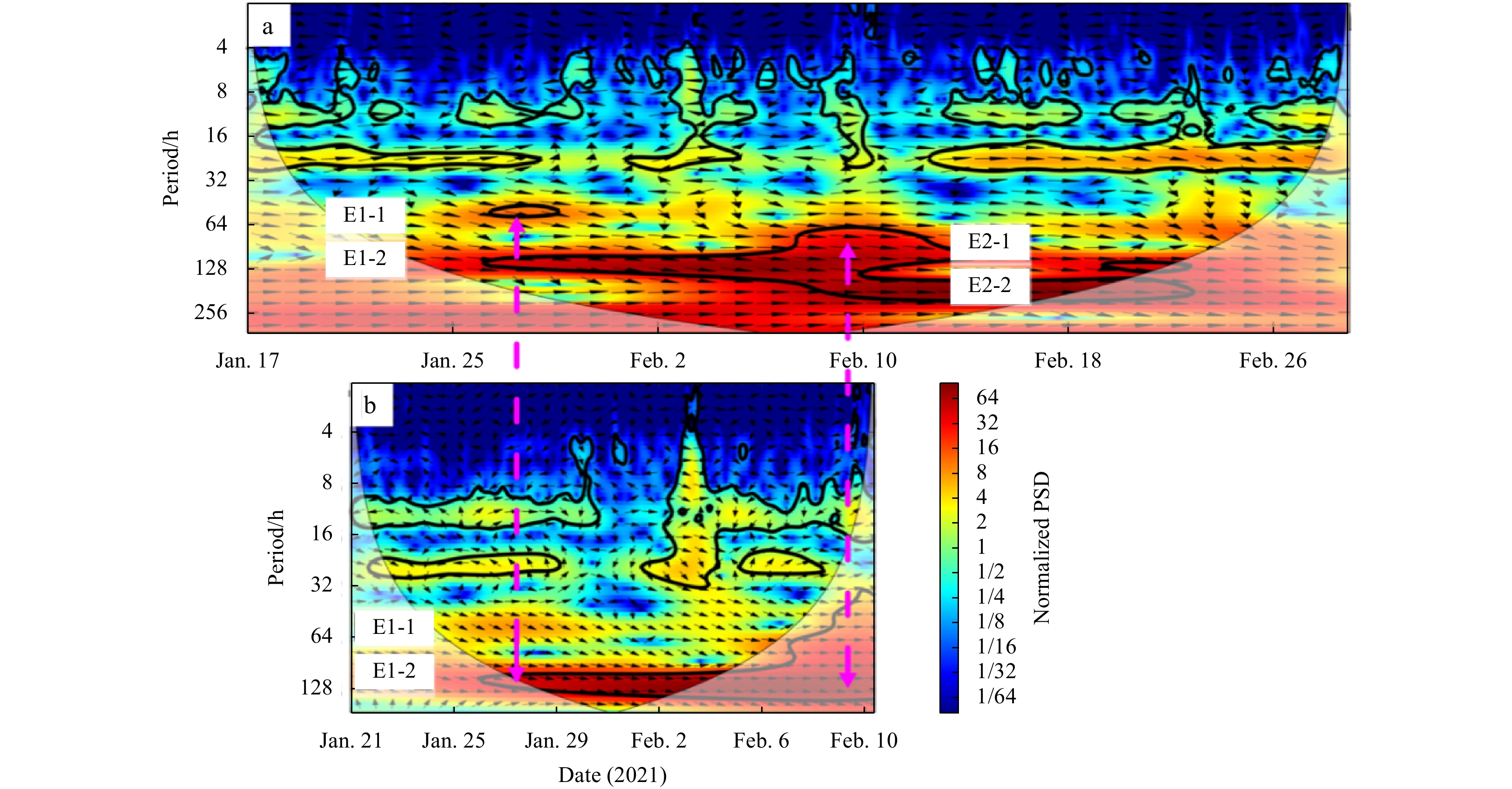
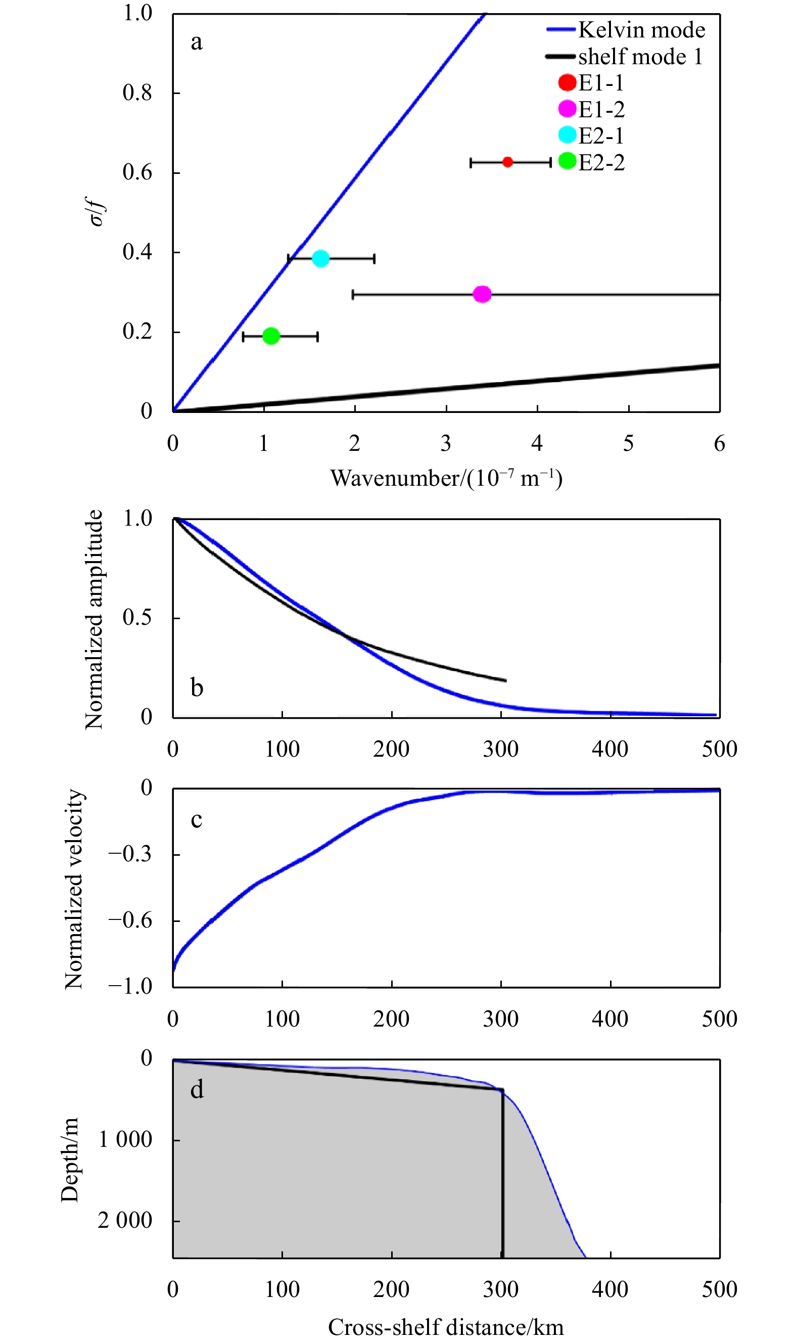
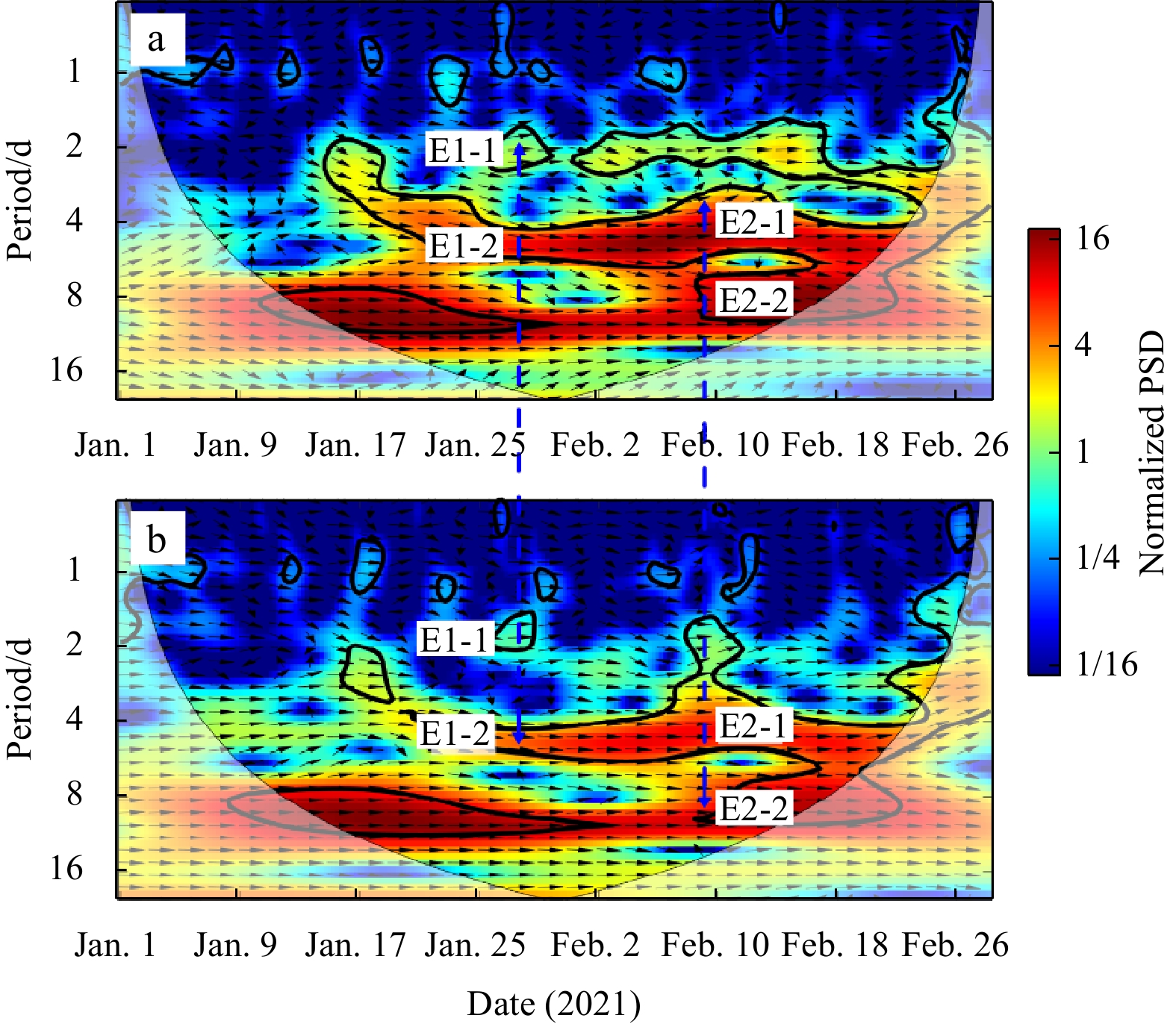
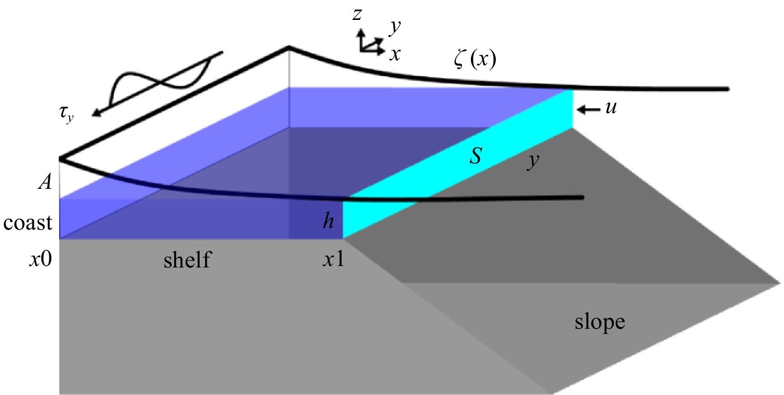
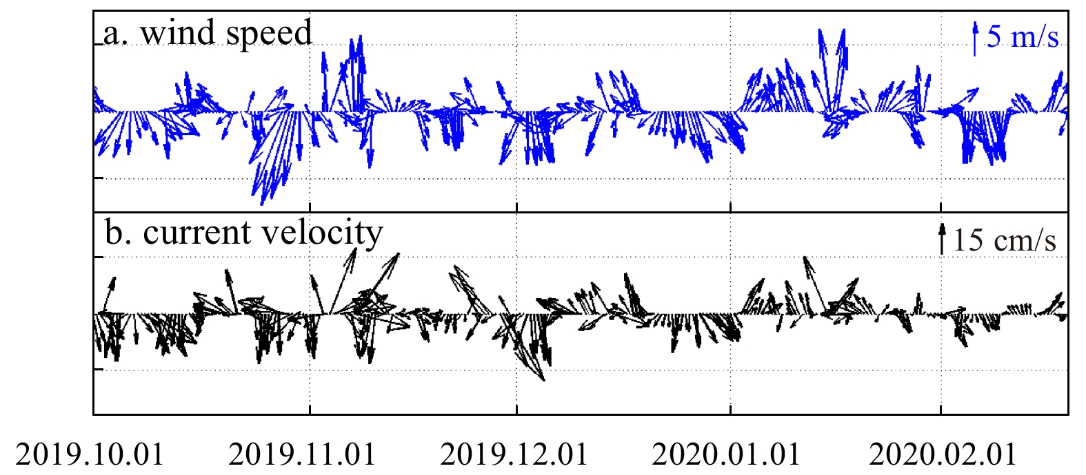
This study aims to investigate characteristics of continental shelf wave (CSW) on the northwestern continental shelf of the South China Sea (SCS) induced by winter storms in 2021. Mooring and cruise observations, tidal gauge data at stations Hong Kong, Zhapo and Qinglan and sea surface wind data from January 1 to February 28, 2021 are used to examine the relationship between along-shelf wind and sea level fluctuation. Two events of CSWs driven by the along-shelf sea surface wind are detected from wavelet spectra of tidal gauge data. The signals are triply peaked at periods of 56 h, 94 h and 180 h, propagating along the coast with phase speed ranging from 6.9 m/s to 18.9 m/s. The dispersion relation shows their property of the Kelvin mode of CSW. We develop a simple method to estimate amplitude of sea surface fluctuation by along-shelf wind. The results are comparable with the observation data, suggesting it is effective. The mode 2 CSWs fits very well with the mooring current velocity data. The results from rare current help to understand wave-current interaction in the northwestern SCS.
This study aims to investigate characteristics of continental shelf wave (CSW) on the northwestern continental shelf of the South China Sea (SCS) induced by winter storms in 2021. Mooring and cruise observations, tidal gauge data at stations Hong Kong, Zhapo and Qinglan and sea surface wind data from January 1 to February 28, 2021 are used to examine the relationship between along-shelf wind and sea level fluctuation. Two events of CSWs driven by the along-shelf sea surface wind are detected from wavelet spectra of tidal gauge data. The signals are triply peaked at periods of 56 h, 94 h and 180 h, propagating along the coast with phase speed ranging from 6.9 m/s to 18.9 m/s. The dispersion relation shows their property of the Kelvin mode of CSW. We develop a simple method to estimate amplitude of sea surface fluctuation by along-shelf wind. The results are comparable with the observation data, suggesting it is effective. The mode 2 CSWs fits very well with the mooring current velocity data. The results from rare current help to understand wave-current interaction in the northwestern SCS.


2024, 43(1): 70-79.
doi: 10.1007/s13131-023-2202-x
Abstract:
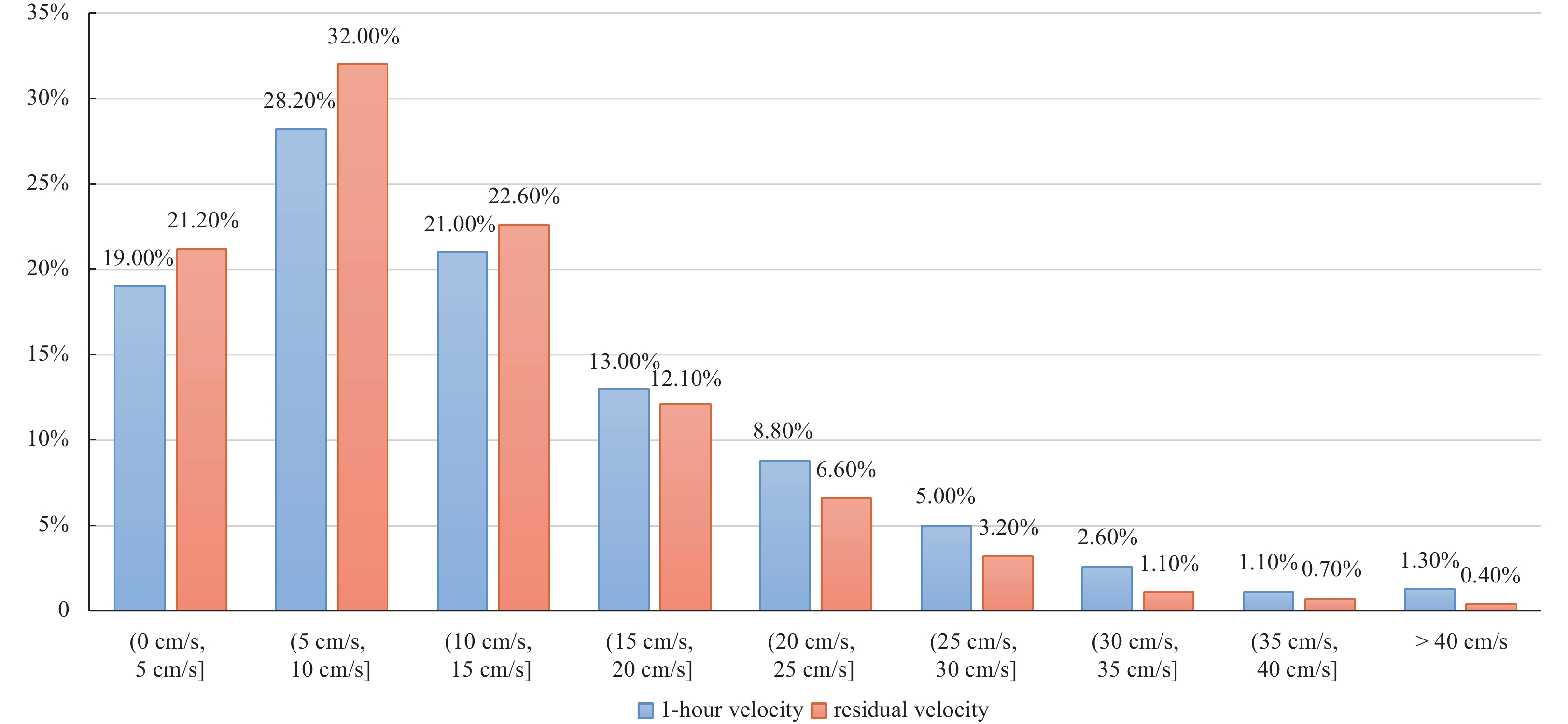
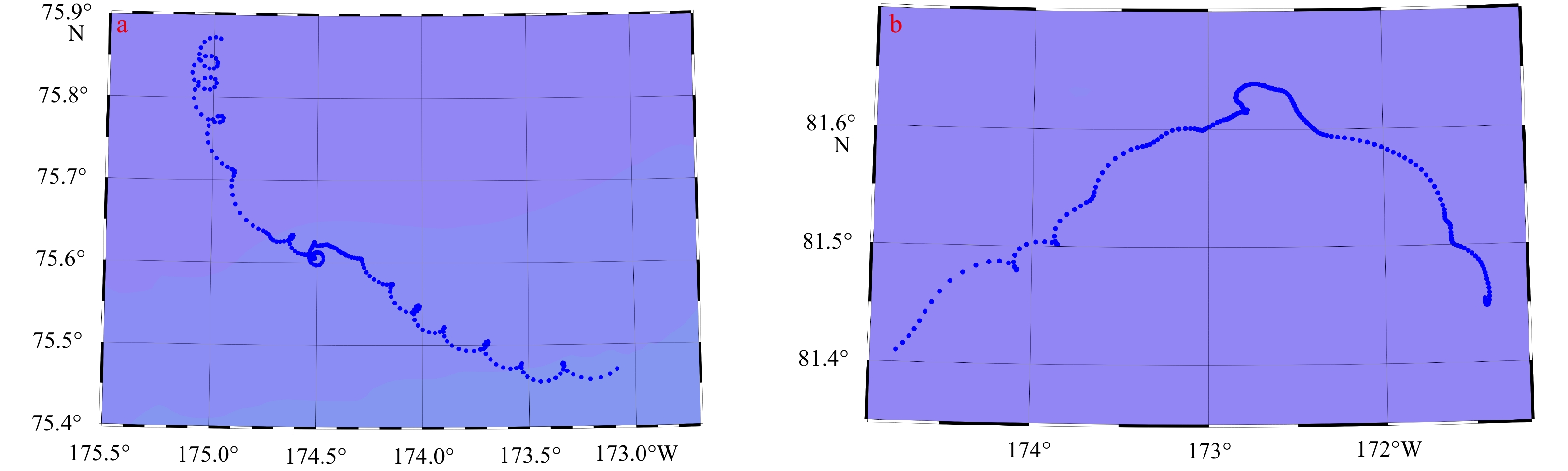
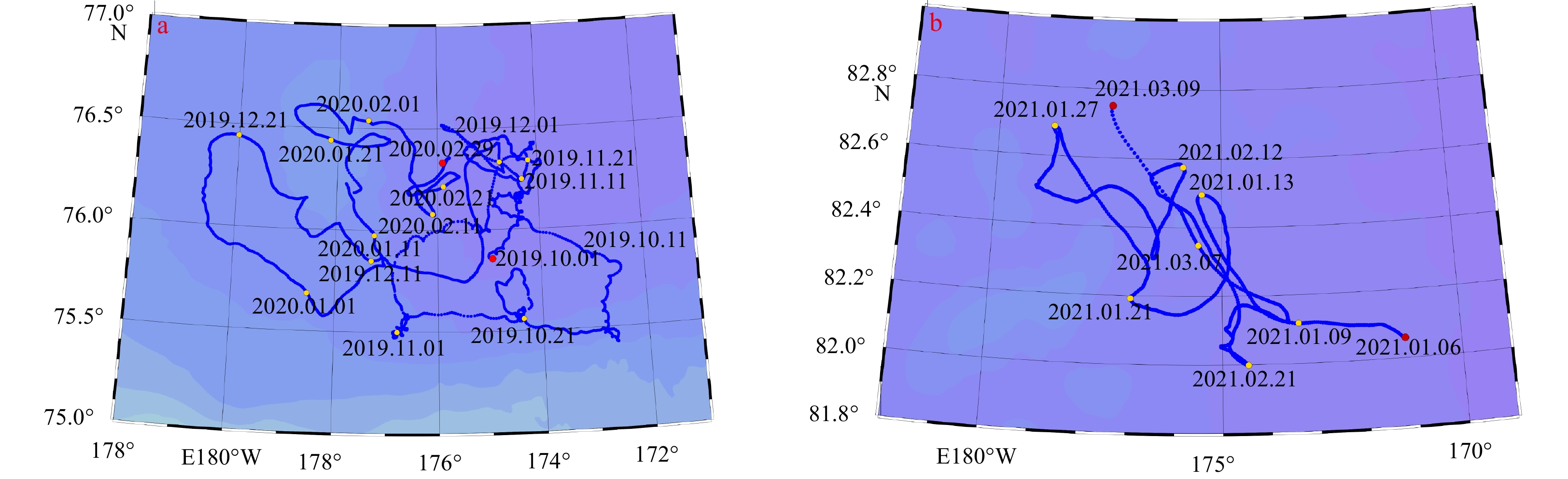
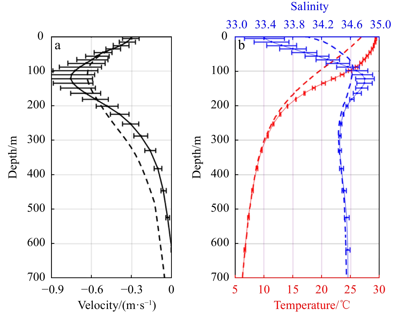
During the 10th Chinese Arctic scientific expedition carried out in the summer of 2019, the surface current in the high-latitude areas of the Arctic Ocean was observed using a self-developed surface drifting buoy, which was initially deployed in the Chukchi Sea. The buoy traversed the Chukchi Sea, Chukchi Abyssal Plain, Mendeleev Ridge, Makarov Basin, and Canada Basin over a period of 632 d. After returning to the Mendeleev Ridge, it continued to drift toward the pole. Overall, the track of the buoy reflected the characteristics of the transpolar drift and Chukchi Slope Current, as well as the inertial flow, cross-ridge surface flow, and even the surface disorganized flow for some time intervals. The results showed that: (1) the transpolar drift mainly occurs in the Chukchi Abyssal Plain, Mendeleev Ridge, and western Canada Basin to the east of the ridge where sea ice concentration is high, and the average northward flow velocity in the region between 79.41°N and 86.32°N was 5.1 cm/s; (2) the average surface velocity of the Chukchi Slope Current was 13.5 cm/s, and while this current moves westward along the continental slope, it also extends northwestward across the continental slope and flows to the deep sea; and (3) when sea ice concentration was less than 50%, the inertial flow was more significant (the maximum observed inertial flow was 26 cm/s, and the radius of the inertia circle was 3.6 km).
During the 10th Chinese Arctic scientific expedition carried out in the summer of 2019, the surface current in the high-latitude areas of the Arctic Ocean was observed using a self-developed surface drifting buoy, which was initially deployed in the Chukchi Sea. The buoy traversed the Chukchi Sea, Chukchi Abyssal Plain, Mendeleev Ridge, Makarov Basin, and Canada Basin over a period of 632 d. After returning to the Mendeleev Ridge, it continued to drift toward the pole. Overall, the track of the buoy reflected the characteristics of the transpolar drift and Chukchi Slope Current, as well as the inertial flow, cross-ridge surface flow, and even the surface disorganized flow for some time intervals. The results showed that: (1) the transpolar drift mainly occurs in the Chukchi Abyssal Plain, Mendeleev Ridge, and western Canada Basin to the east of the ridge where sea ice concentration is high, and the average northward flow velocity in the region between 79.41°N and 86.32°N was 5.1 cm/s; (2) the average surface velocity of the Chukchi Slope Current was 13.5 cm/s, and while this current moves westward along the continental slope, it also extends northwestward across the continental slope and flows to the deep sea; and (3) when sea ice concentration was less than 50%, the inertial flow was more significant (the maximum observed inertial flow was 26 cm/s, and the radius of the inertia circle was 3.6 km).


2024, 43(1): 80-98.
doi: 10.1007/s13131-023-2186-6
Abstract:
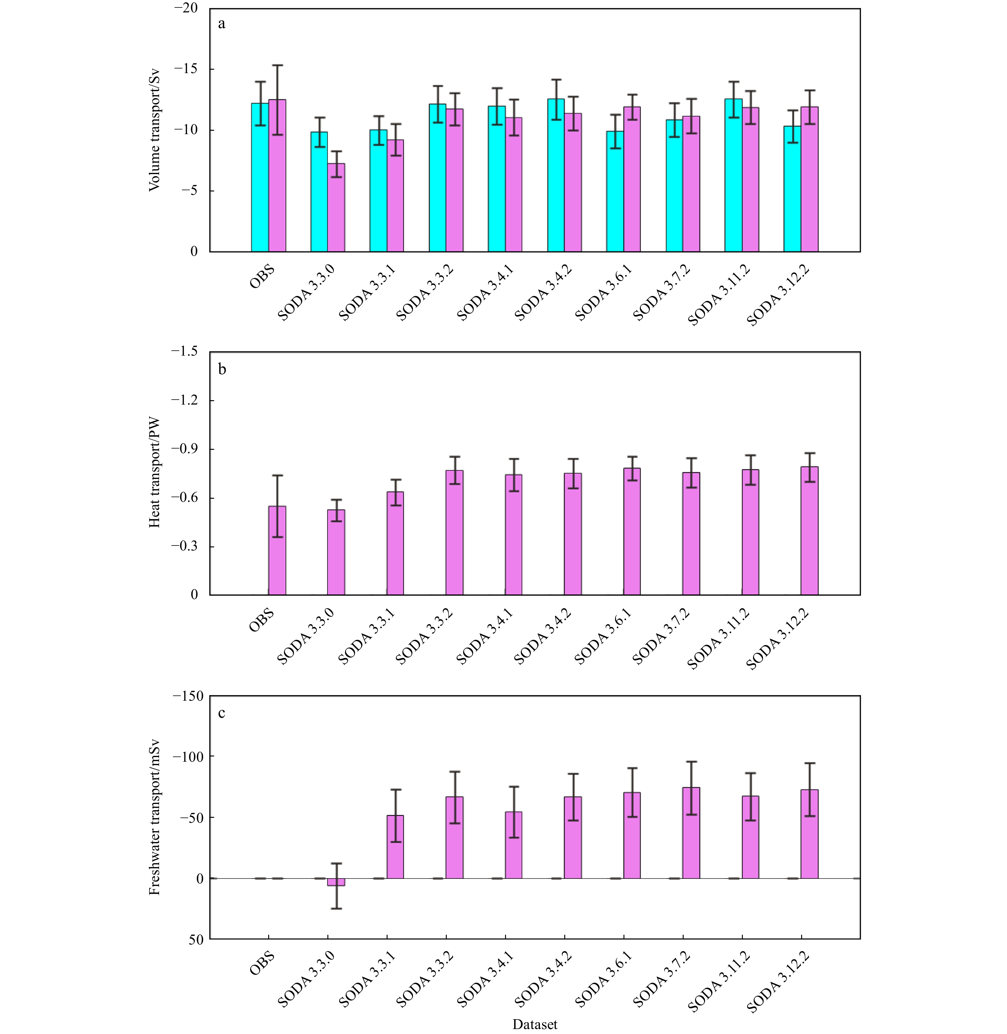
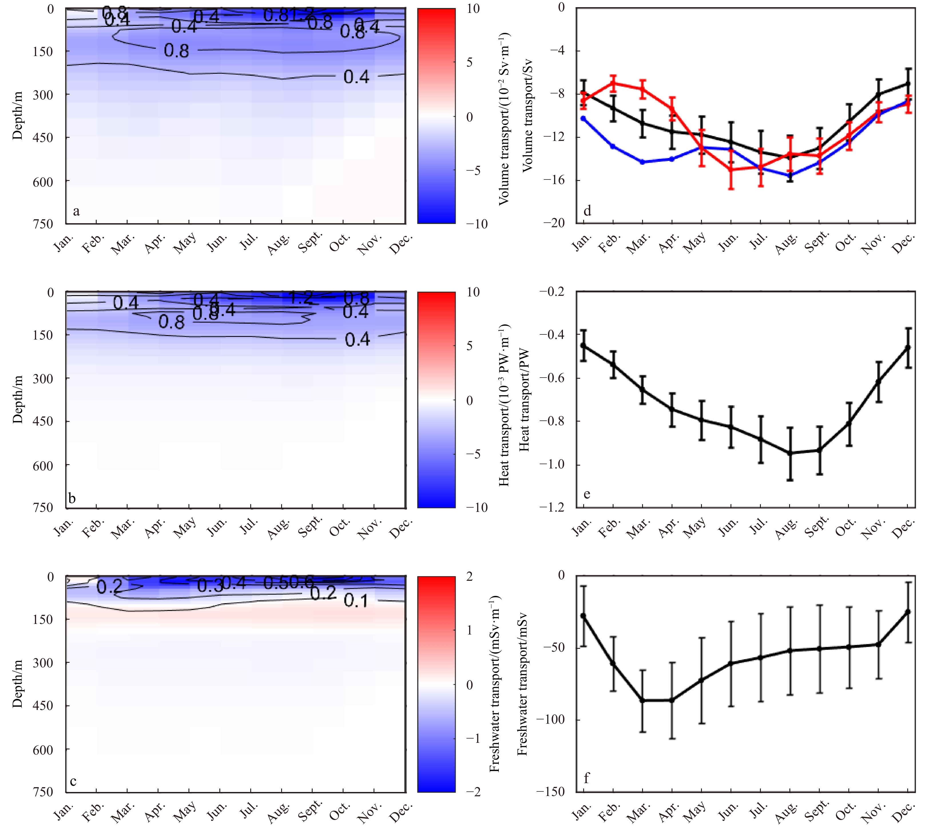
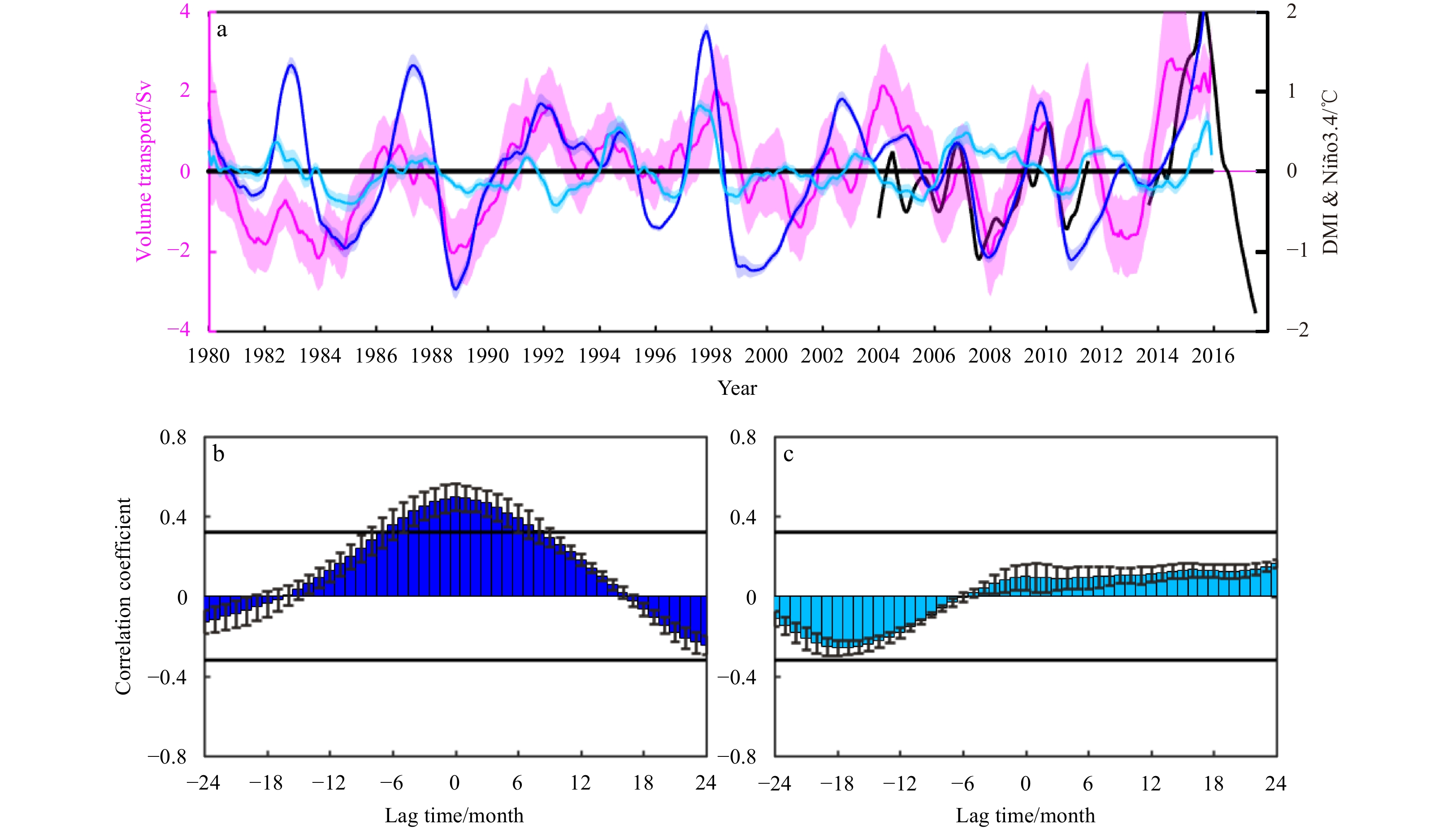
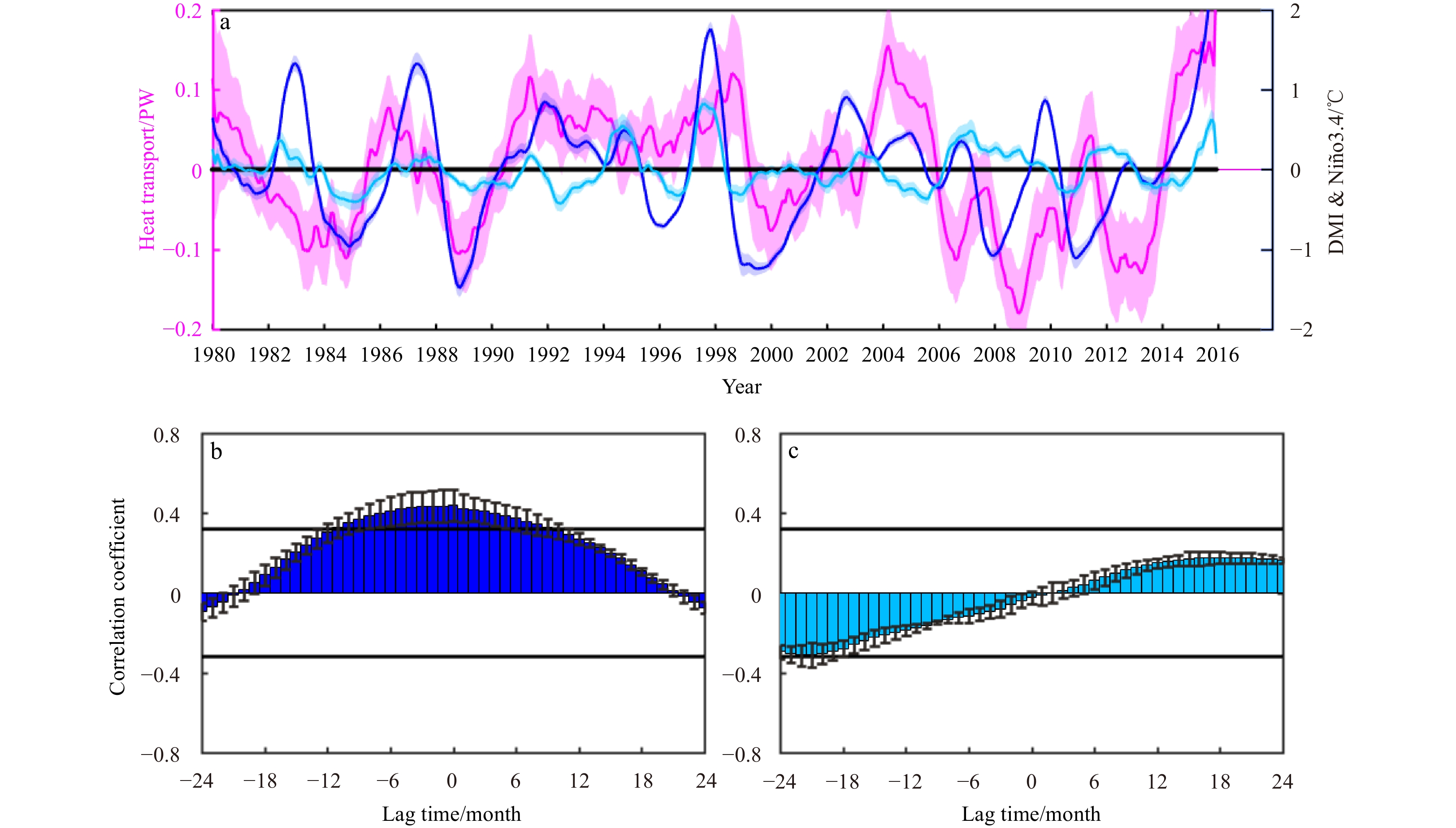
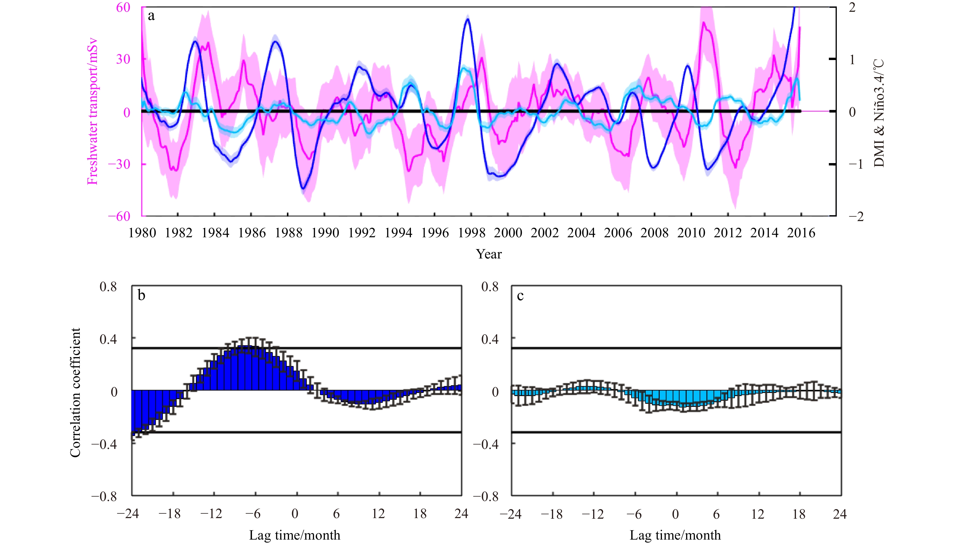
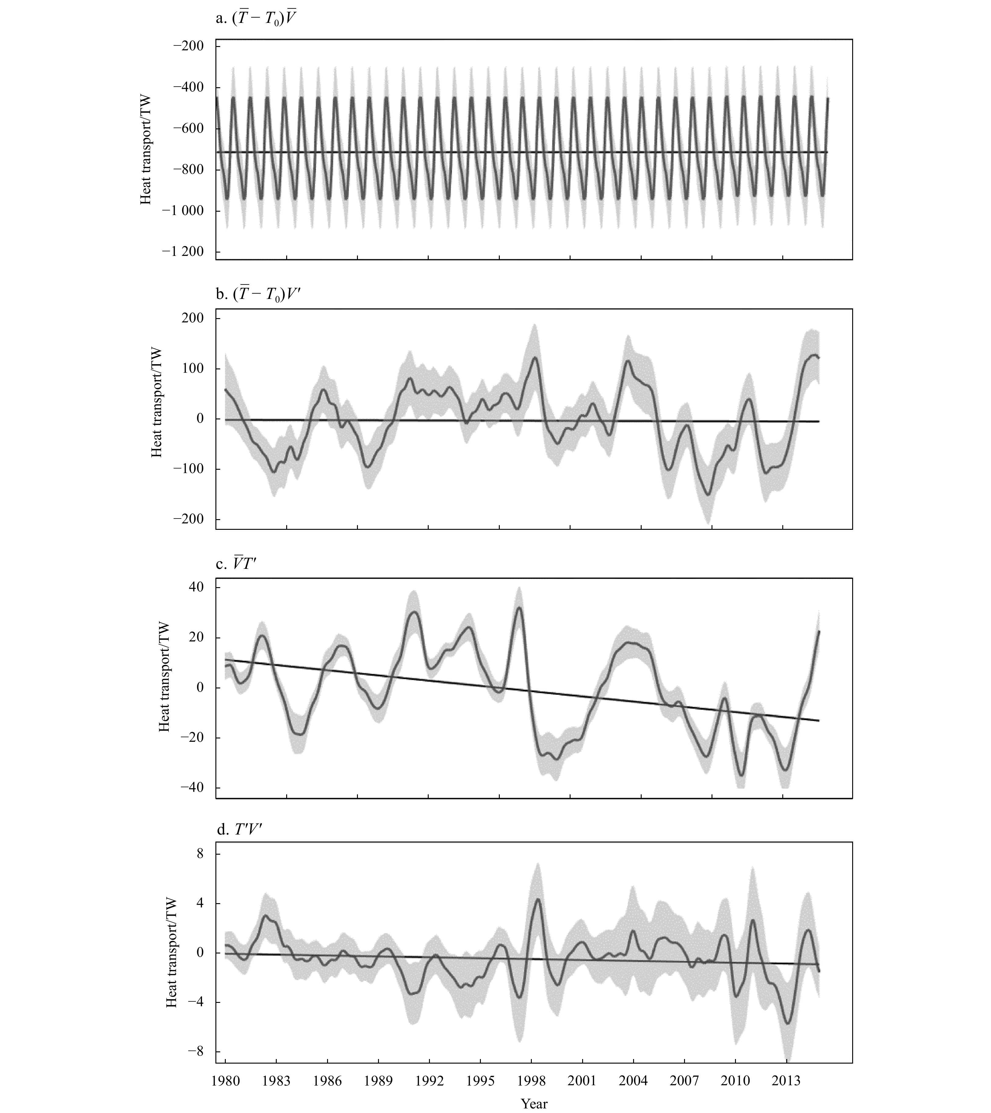
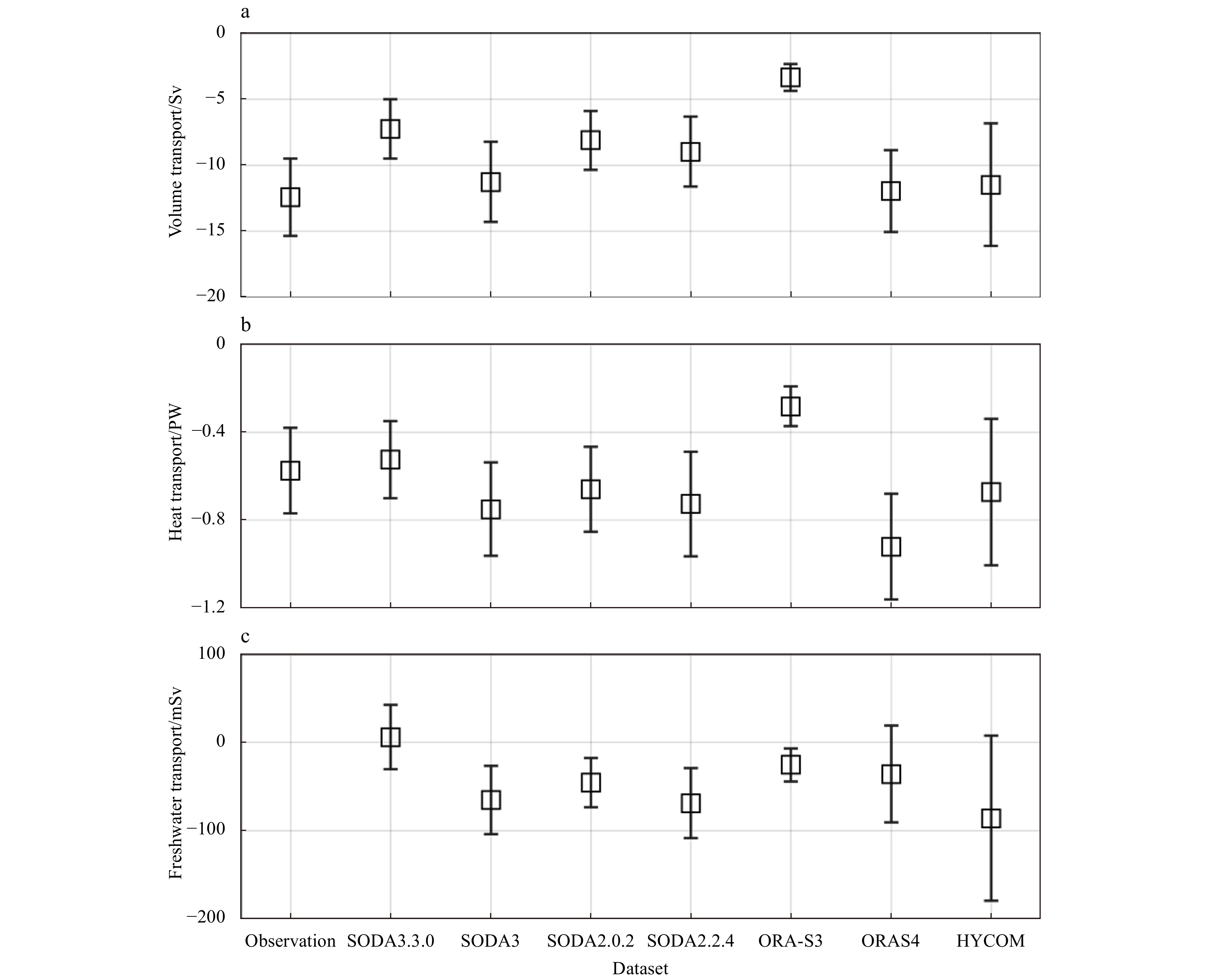
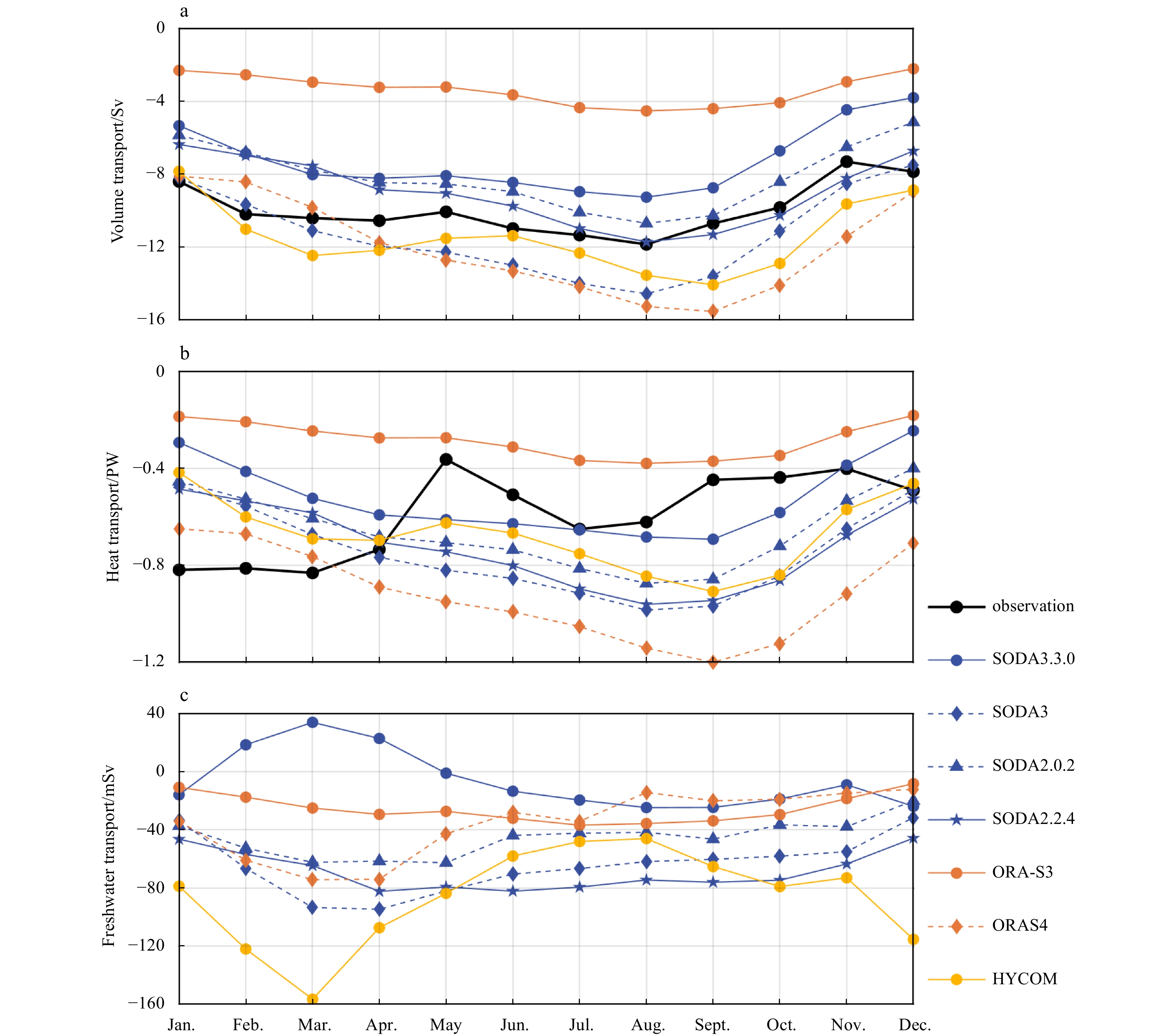
The Indonesian Throughflow (ITF), which connects the tropical Pacific and Indian oceans, plays important roles in the inter-ocean water exchange and regional or even global climate variability. The Makassar Strait is the main inflow passage of the ITF, carrying about 77% of the total ITF volume transport. In this study, we analyze the simulated ITF in the Makassar Strait in the Simple Ocean Data Assimilation version 3 (SODA3) datasets. A total of nine ensemble members of the SODA3 datasets, of which are driven by different surface forcings and bulk formulas, and with or without data assimilation, are used in this study. The annual mean water transports (i.e., volume, heat and freshwater) are related to the combination of surface forcing and bulk formula, as well as whether data assimilation is employed. The phases of the seasonal and interannual variability in water transports cross the Makassar Strait, are basically consistent with each other among the SODA3 ensemble members. The interannual variability in Makassar Strait volume and heat transports are significantly correlated with El Niño-Southern Oscillation (ENSO) at time lags of −6 to 7 months. There is no statistically significant correlation between the freshwater transport and the ENSO. The Makassar Strait water transports are not significantly correlated with the Indian Ocean Dipole (IOD), which may attribute to model deficiency in simulating the propagation of semi-annual Kelvin waves from the Indian Ocean to the Makassar Strait.
The Indonesian Throughflow (ITF), which connects the tropical Pacific and Indian oceans, plays important roles in the inter-ocean water exchange and regional or even global climate variability. The Makassar Strait is the main inflow passage of the ITF, carrying about 77% of the total ITF volume transport. In this study, we analyze the simulated ITF in the Makassar Strait in the Simple Ocean Data Assimilation version 3 (SODA3) datasets. A total of nine ensemble members of the SODA3 datasets, of which are driven by different surface forcings and bulk formulas, and with or without data assimilation, are used in this study. The annual mean water transports (i.e., volume, heat and freshwater) are related to the combination of surface forcing and bulk formula, as well as whether data assimilation is employed. The phases of the seasonal and interannual variability in water transports cross the Makassar Strait, are basically consistent with each other among the SODA3 ensemble members. The interannual variability in Makassar Strait volume and heat transports are significantly correlated with El Niño-Southern Oscillation (ENSO) at time lags of −6 to 7 months. There is no statistically significant correlation between the freshwater transport and the ENSO. The Makassar Strait water transports are not significantly correlated with the Indian Ocean Dipole (IOD), which may attribute to model deficiency in simulating the propagation of semi-annual Kelvin waves from the Indian Ocean to the Makassar Strait.


2024, 43(1): 99-111.
doi: 10.1007/s13131-023-2230-6
Abstract:
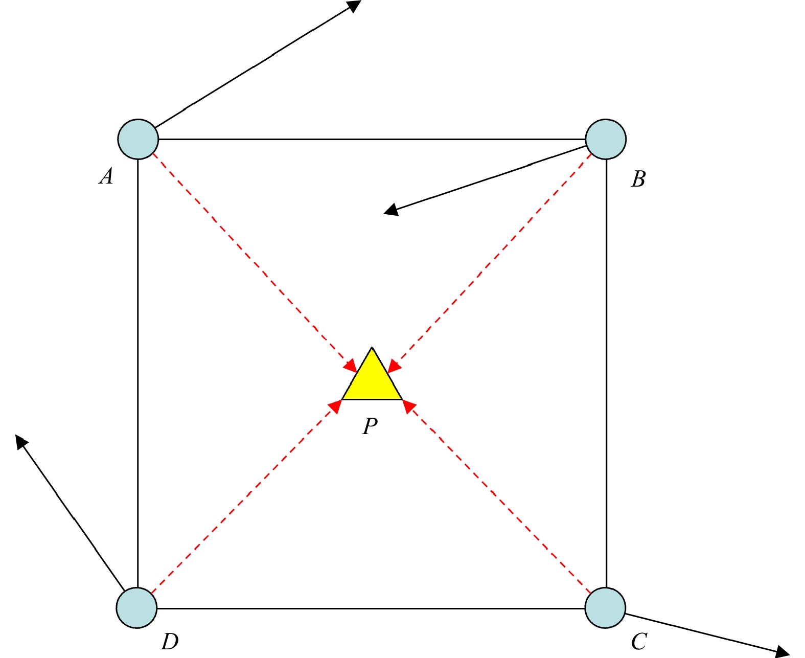
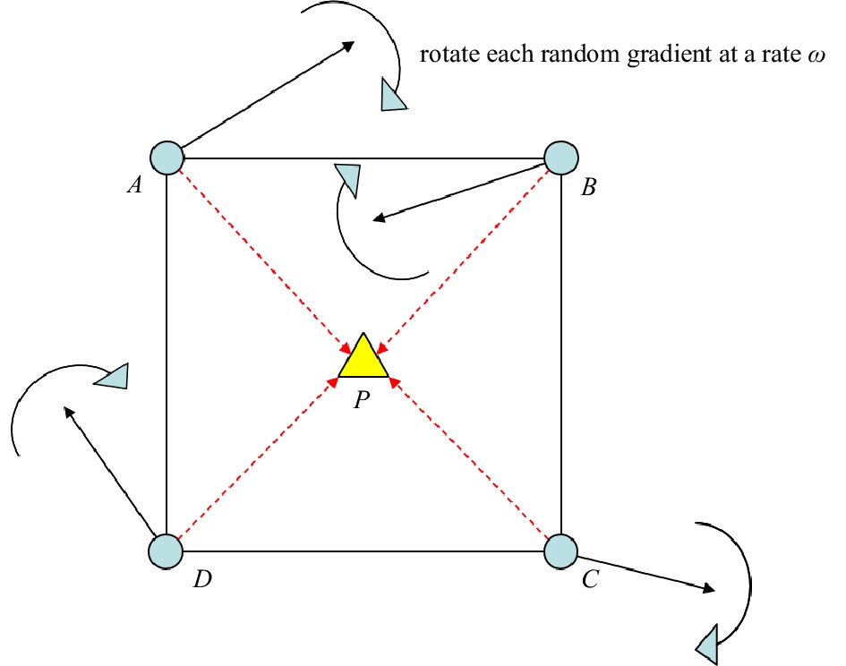
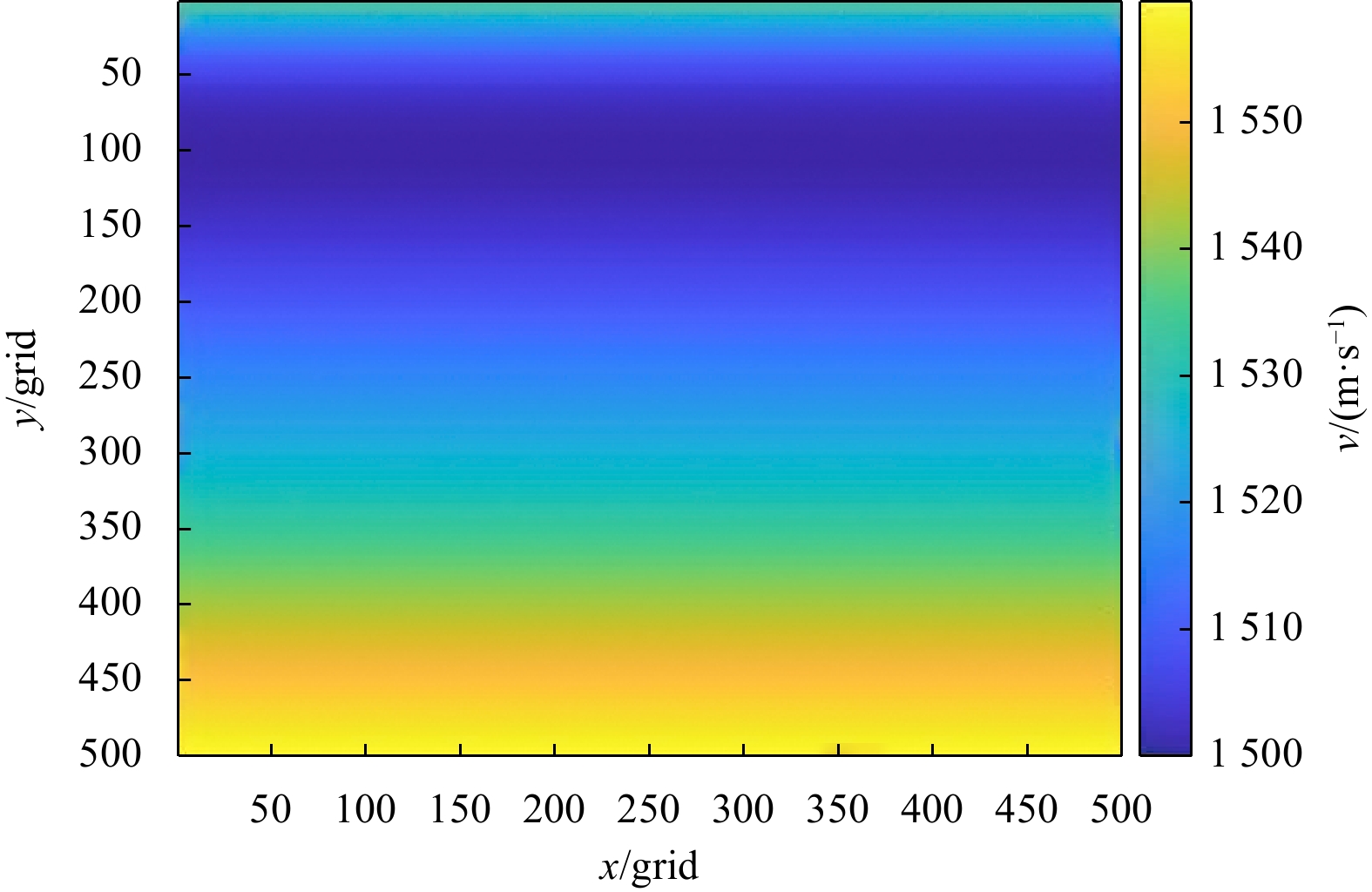
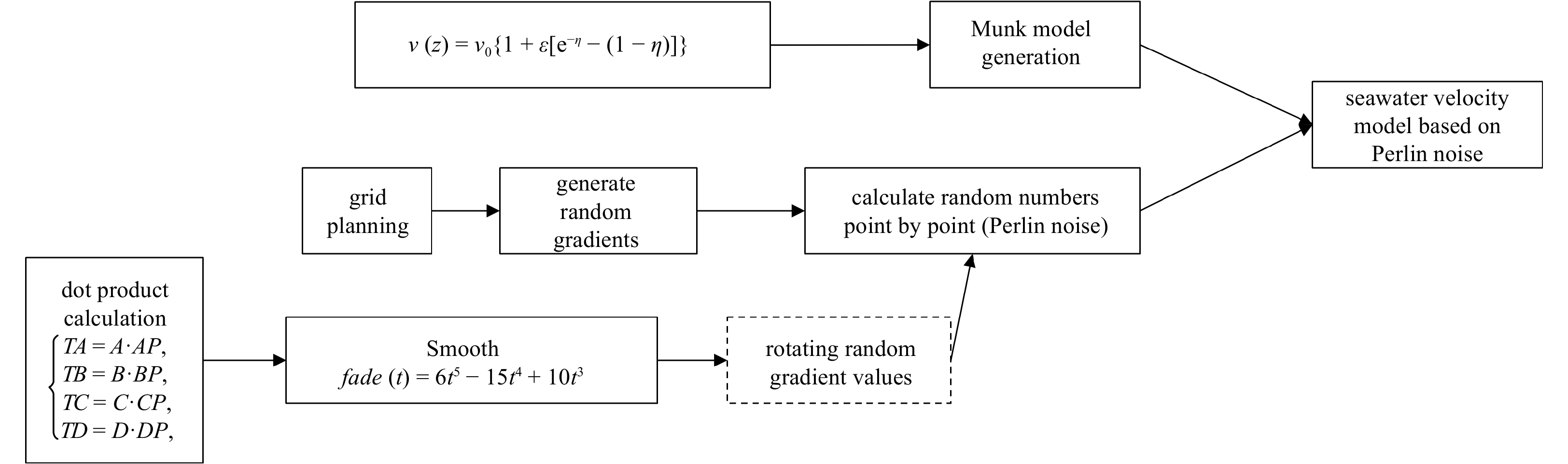
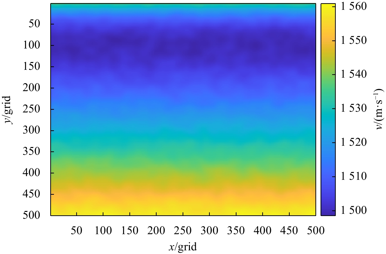
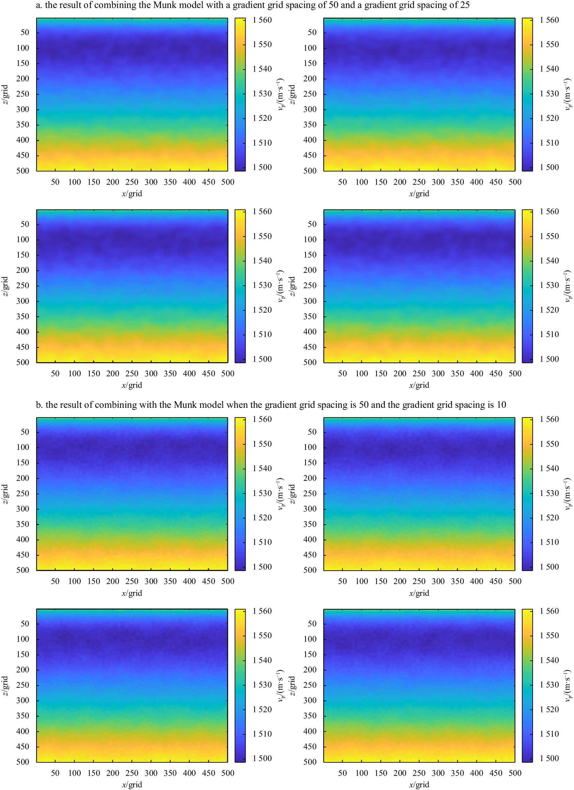
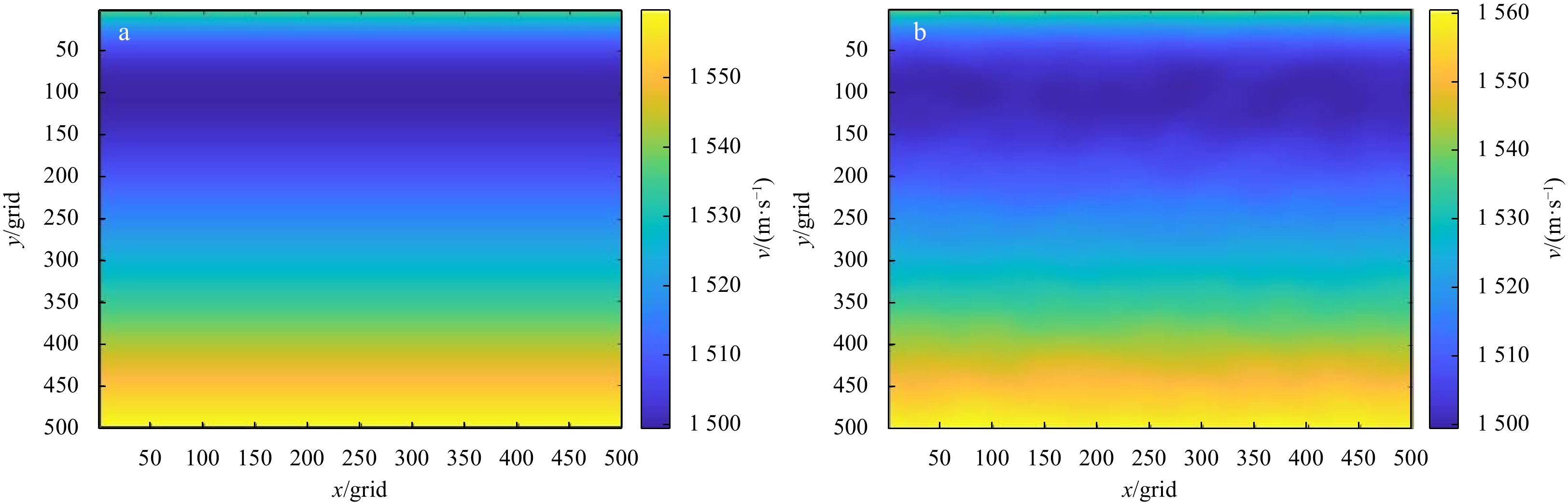
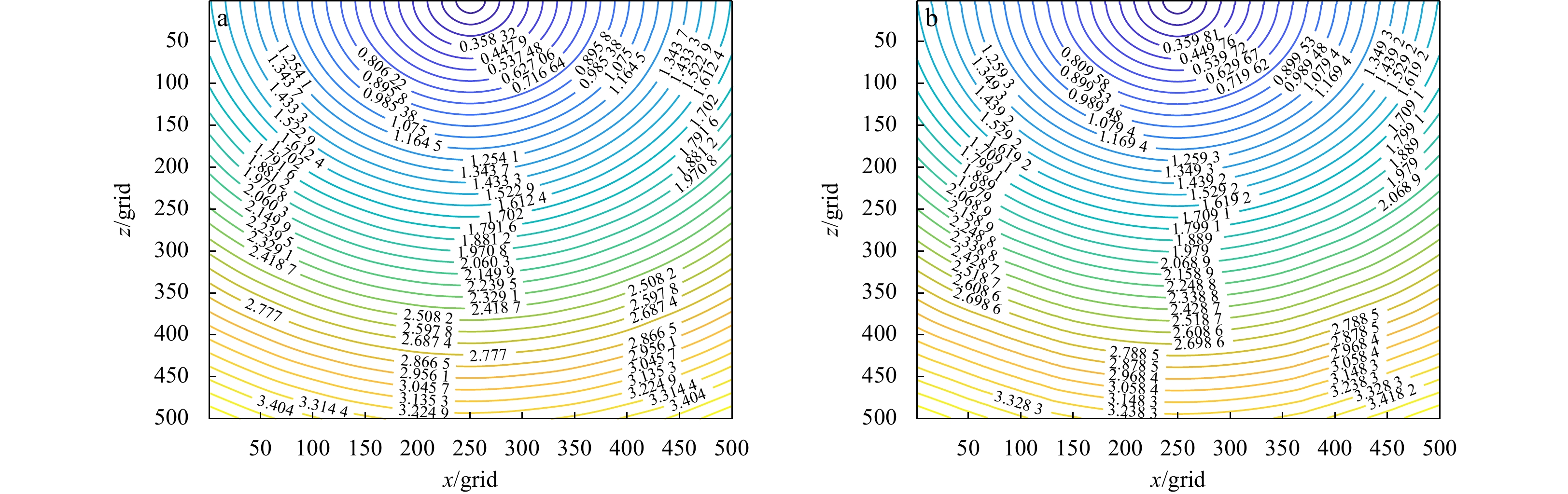
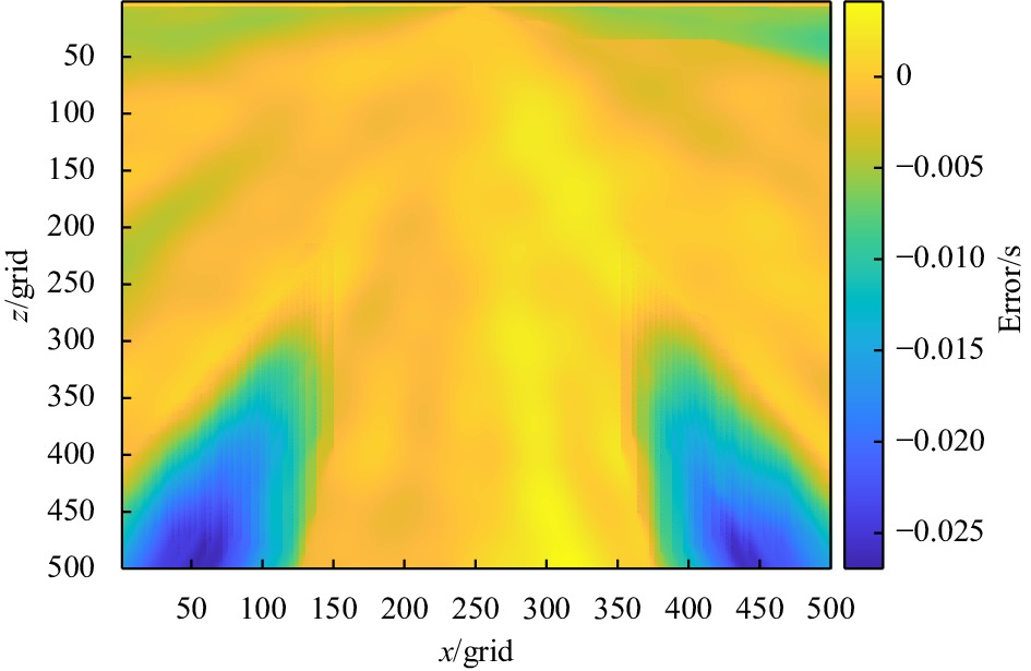
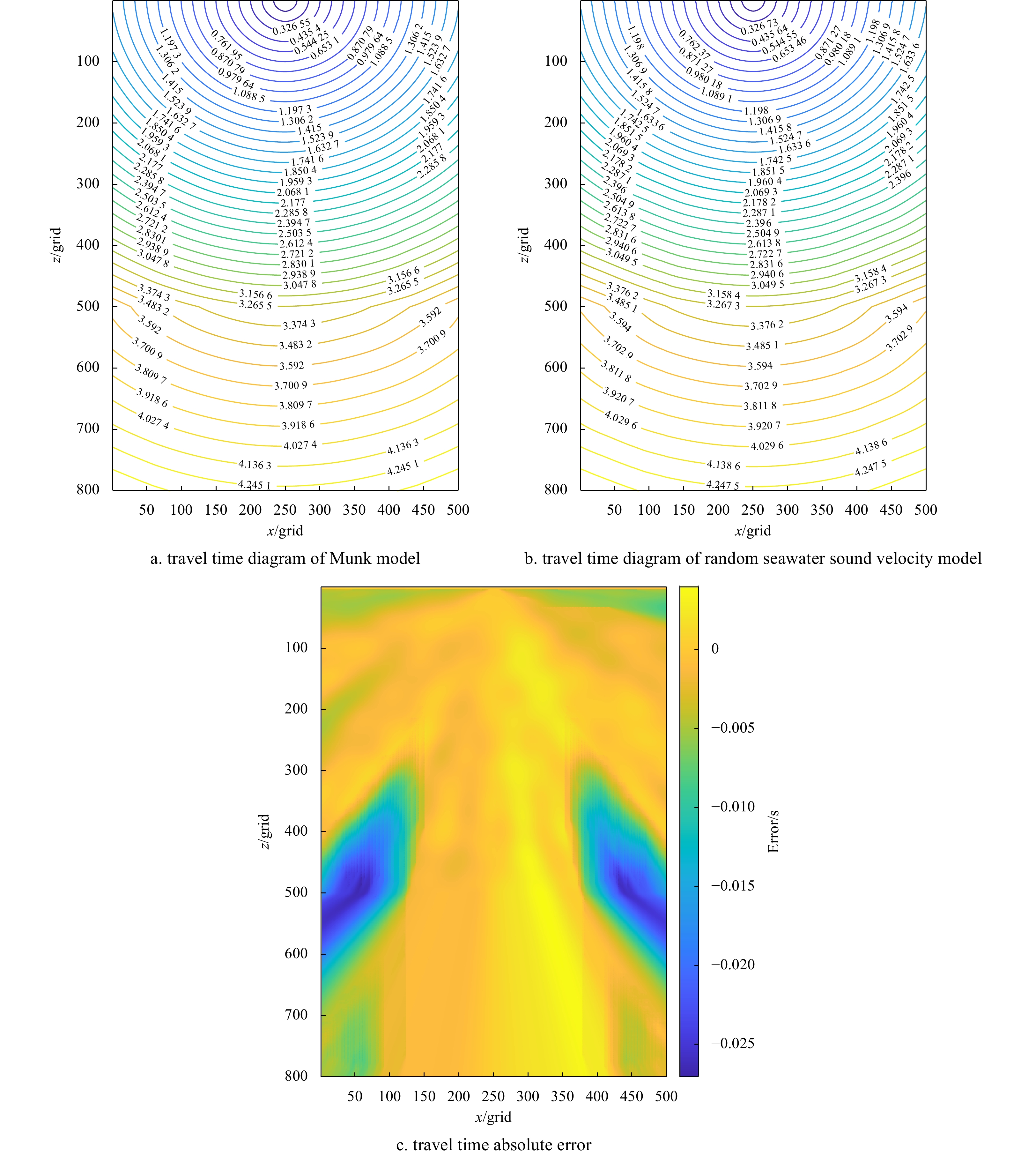
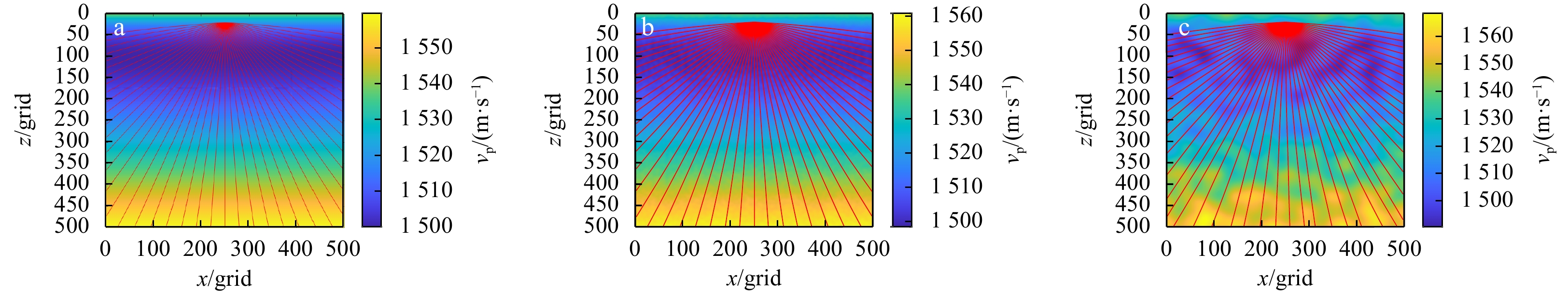
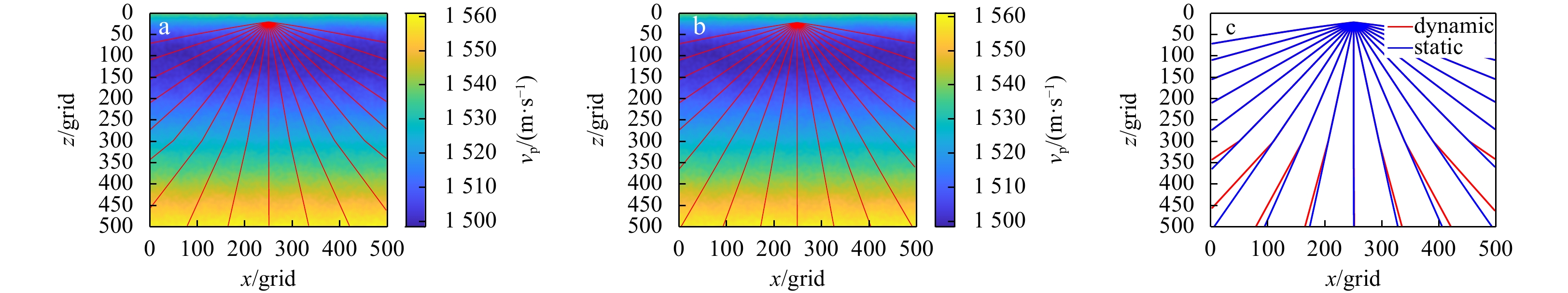
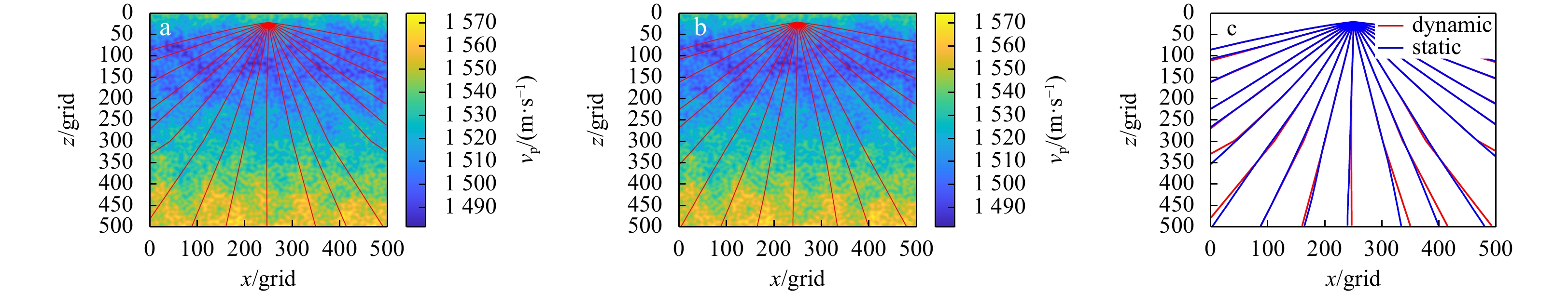
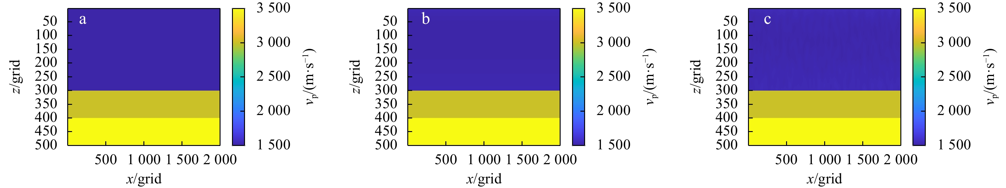
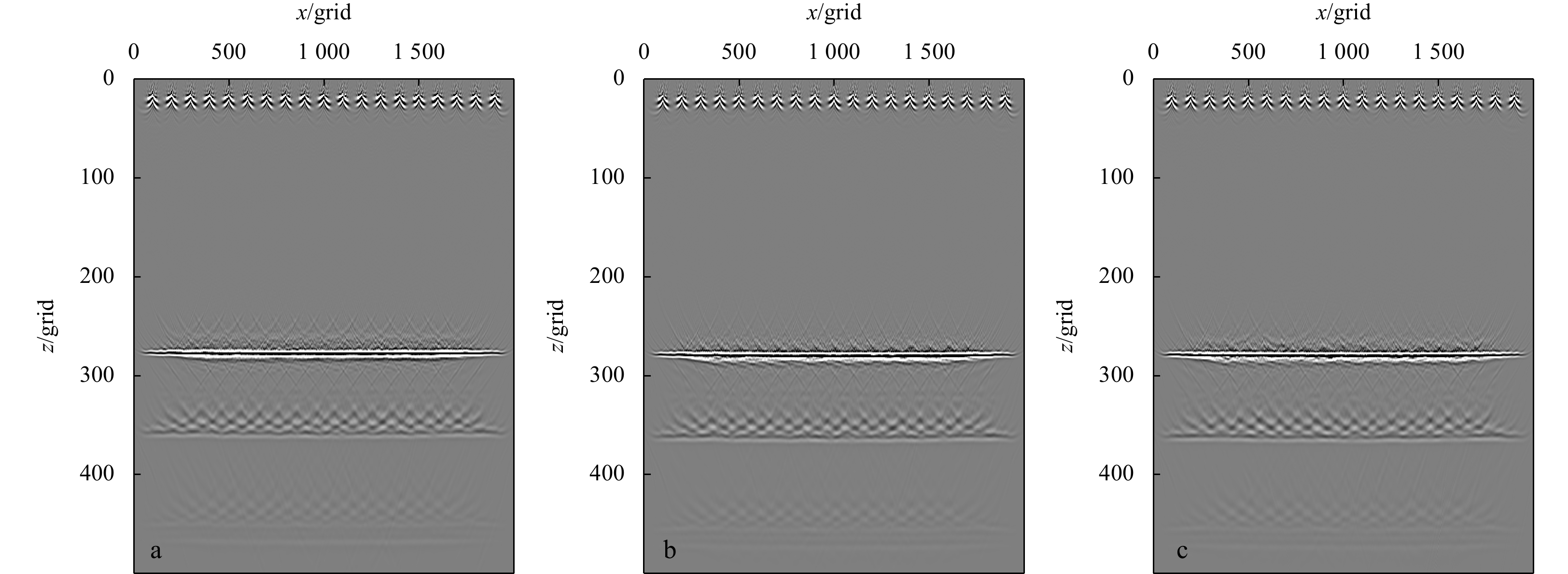
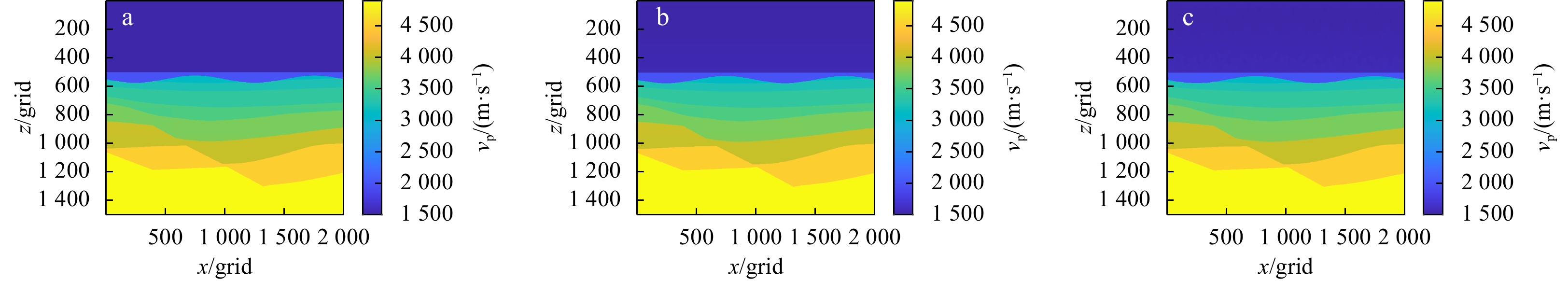
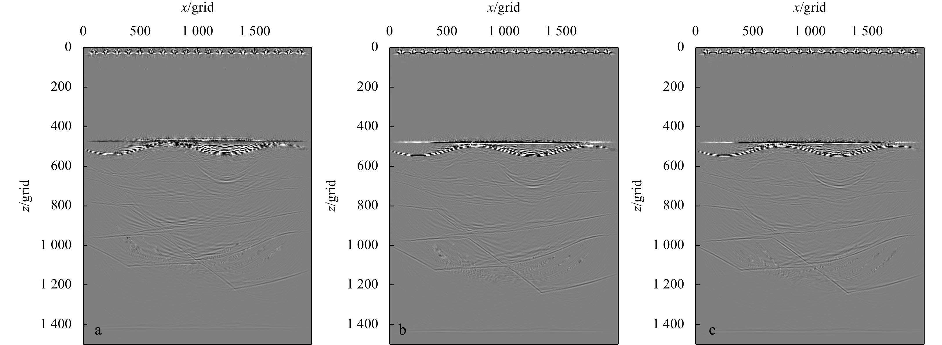
In the processing of conventional marine seismic data, seawater is often assumed to have a constant velocity model. However, due to static pressure, temperature difference and other factors, random disturbances may often frequently in seawater bodies. The impact of such disturbances on data processing results is a topic of theoretical research. Since seawater sound velocity is a difficult physical quantity to measure, there is a need for a method that can generate models conforming to seawater characteristics. This article will combine the Munk model and Perlin noise to propose a two-dimensional dynamic seawater sound velocity model generation method, a method that can generate a dynamic, continuous, random seawater sound velocity model with some regularity at large scales. Moreover, the paper discusses the influence of the inhomogeneity characteristics of seawater on wave field propagation and imaging. The results show that the seawater sound velocity model with random disturbance will have a significant influence on the wave field simulation and imaging results.
In the processing of conventional marine seismic data, seawater is often assumed to have a constant velocity model. However, due to static pressure, temperature difference and other factors, random disturbances may often frequently in seawater bodies. The impact of such disturbances on data processing results is a topic of theoretical research. Since seawater sound velocity is a difficult physical quantity to measure, there is a need for a method that can generate models conforming to seawater characteristics. This article will combine the Munk model and Perlin noise to propose a two-dimensional dynamic seawater sound velocity model generation method, a method that can generate a dynamic, continuous, random seawater sound velocity model with some regularity at large scales. Moreover, the paper discusses the influence of the inhomogeneity characteristics of seawater on wave field propagation and imaging. The results show that the seawater sound velocity model with random disturbance will have a significant influence on the wave field simulation and imaging results.


2024, 43(1): 112-122.
doi: 10.1007/s13131-023-2203-9
Abstract:
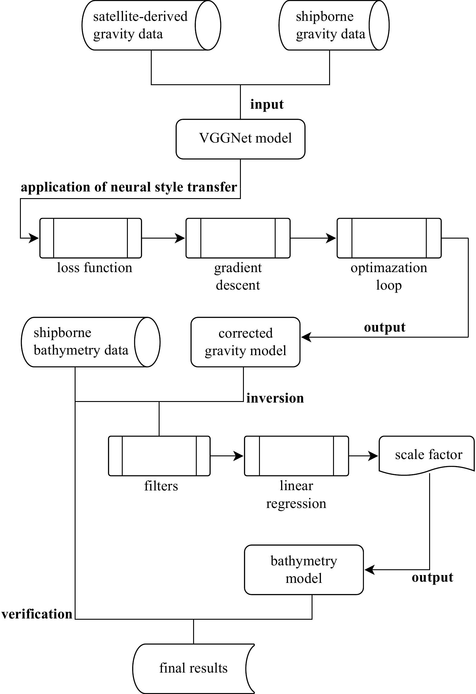
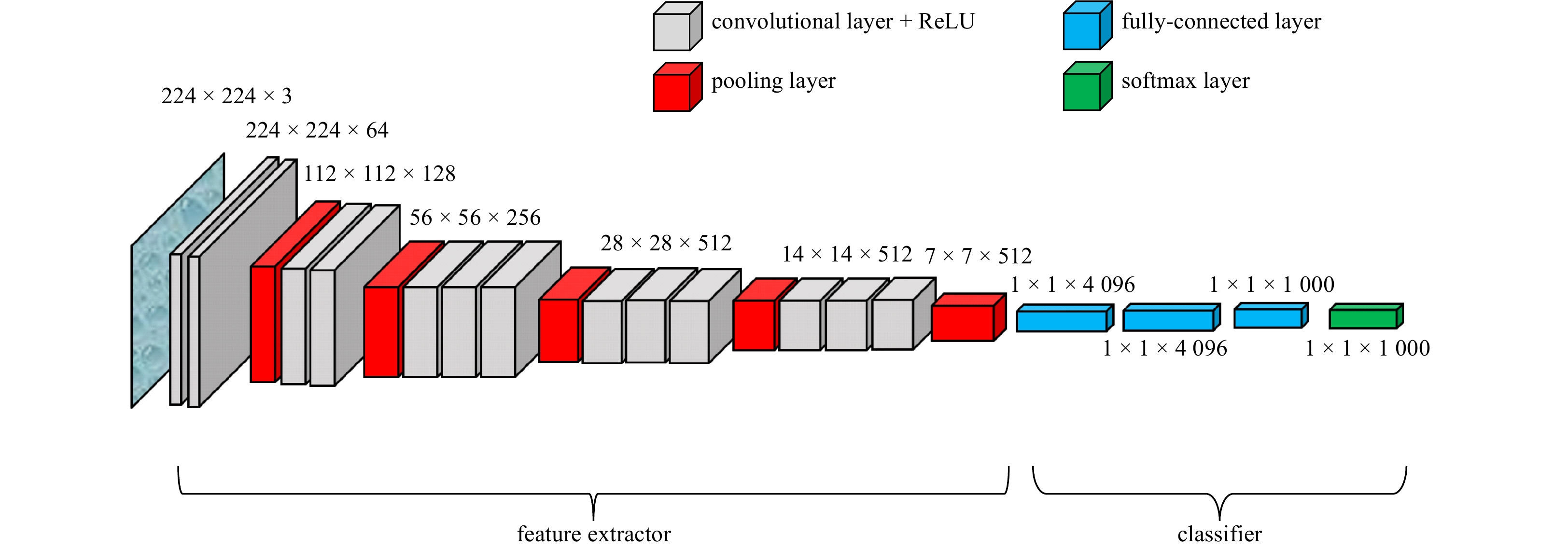
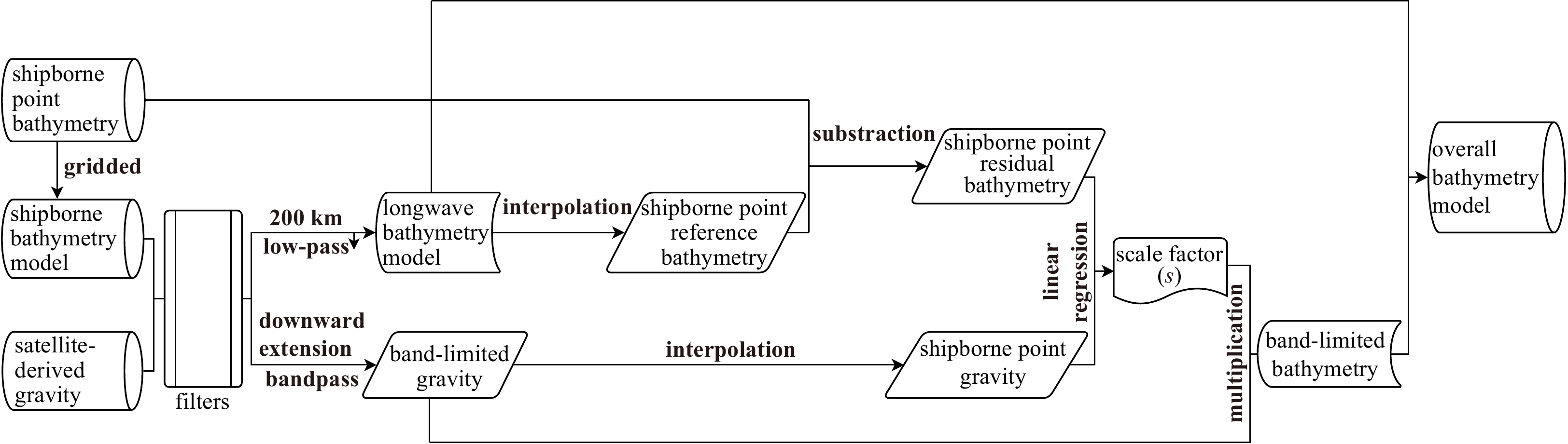
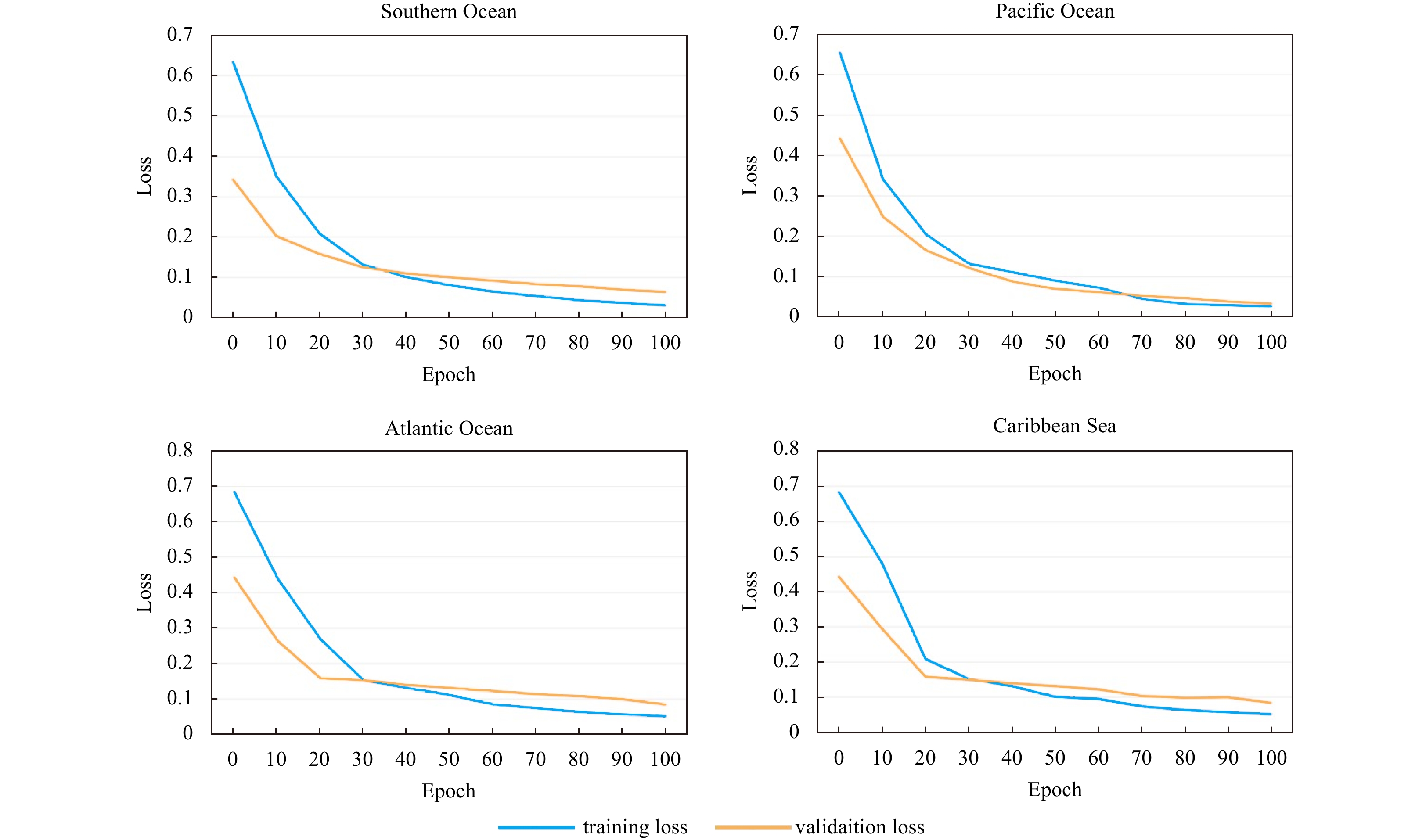
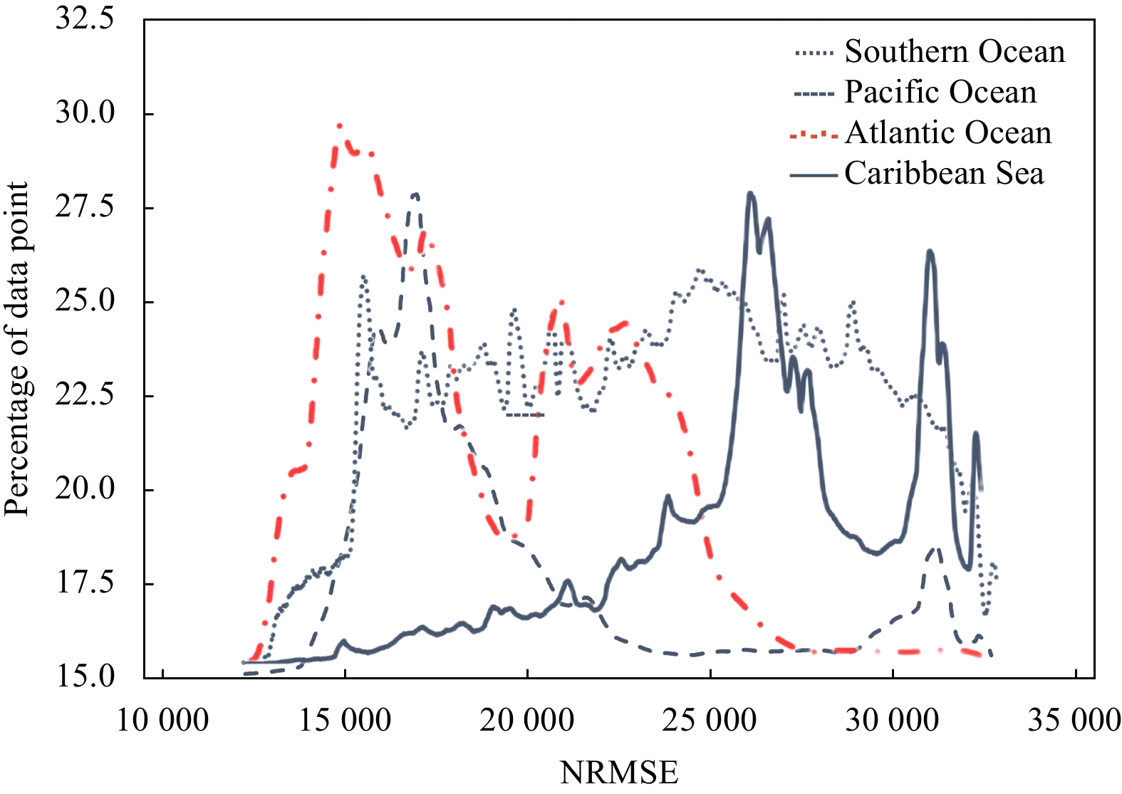
Understanding the topographic patterns of the seafloor is a very important part of understanding our planet. Although the science involved in bathymetric surveying has advanced much over the decades, less than 20% of the seafloor has been precisely modeled to date, and there is an urgent need to improve the accuracy and reduce the uncertainty of underwater survey data. In this study, we introduce a pretrained visual geometry group network (VGGNet) method based on deep learning. To apply this method, we input gravity anomaly data derived from ship measurements and satellite altimetry into the model and correct the latter, which has a larger spatial coverage, based on the former, which is considered the true value and is more accurate. After obtaining the corrected high-precision gravity model, it is inverted to the corresponding bathymetric model by applying the gravity-depth correlation. We choose four data pairs collected from different environments, i.e., the Southern Ocean, Pacific Ocean, Atlantic Ocean and Caribbean Sea, to evaluate the topographic correction results of the model. The experiments show that the coefficient of determination (R2) reaches 0.834 among the results of the four experimental groups, signifying a high correlation. The standard deviation and normalized root mean square error are also evaluated, and the accuracy of their performance improved by up to 24.2% compared with similar research done in recent years. The evaluation of the R2 values at different water depths shows that our model can achieve performance results above 0.90 at certain water depths and can also significantly improve results from mid-water depths when compared to previous research. Finally, the bathymetry corrected by our model is able to show an accuracy improvement level of more than 21% within 1% of the total water depths, which is sufficient to prove that the VGGNet-based method has the ability to perform a gravity-bathymetry correction and achieve outstanding results.
Understanding the topographic patterns of the seafloor is a very important part of understanding our planet. Although the science involved in bathymetric surveying has advanced much over the decades, less than 20% of the seafloor has been precisely modeled to date, and there is an urgent need to improve the accuracy and reduce the uncertainty of underwater survey data. In this study, we introduce a pretrained visual geometry group network (VGGNet) method based on deep learning. To apply this method, we input gravity anomaly data derived from ship measurements and satellite altimetry into the model and correct the latter, which has a larger spatial coverage, based on the former, which is considered the true value and is more accurate. After obtaining the corrected high-precision gravity model, it is inverted to the corresponding bathymetric model by applying the gravity-depth correlation. We choose four data pairs collected from different environments, i.e., the Southern Ocean, Pacific Ocean, Atlantic Ocean and Caribbean Sea, to evaluate the topographic correction results of the model. The experiments show that the coefficient of determination (R2) reaches 0.834 among the results of the four experimental groups, signifying a high correlation. The standard deviation and normalized root mean square error are also evaluated, and the accuracy of their performance improved by up to 24.2% compared with similar research done in recent years. The evaluation of the R2 values at different water depths shows that our model can achieve performance results above 0.90 at certain water depths and can also significantly improve results from mid-water depths when compared to previous research. Finally, the bathymetry corrected by our model is able to show an accuracy improvement level of more than 21% within 1% of the total water depths, which is sufficient to prove that the VGGNet-based method has the ability to perform a gravity-bathymetry correction and achieve outstanding results.


2024, 43(1): 123-134.
doi: 10.1007/s13131-023-2187-5
Abstract:
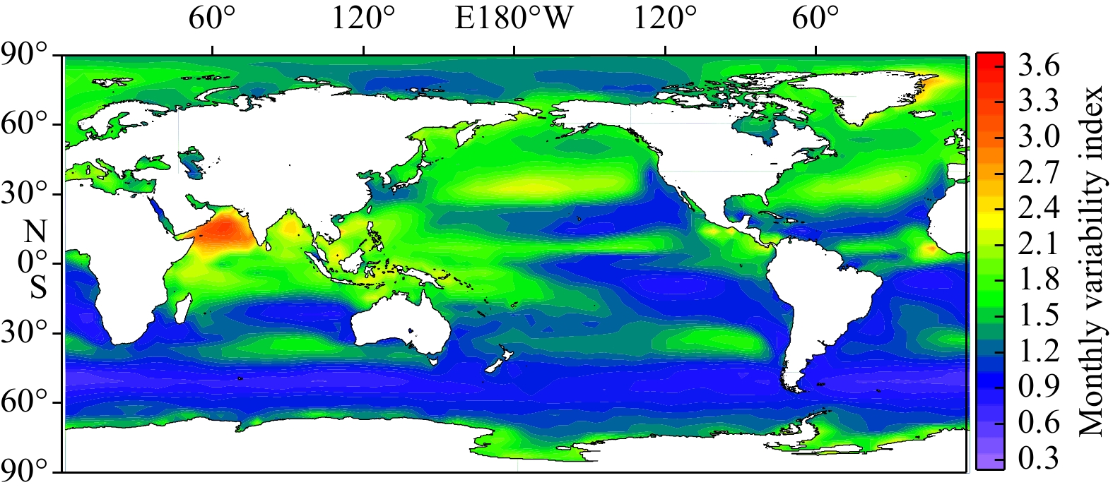
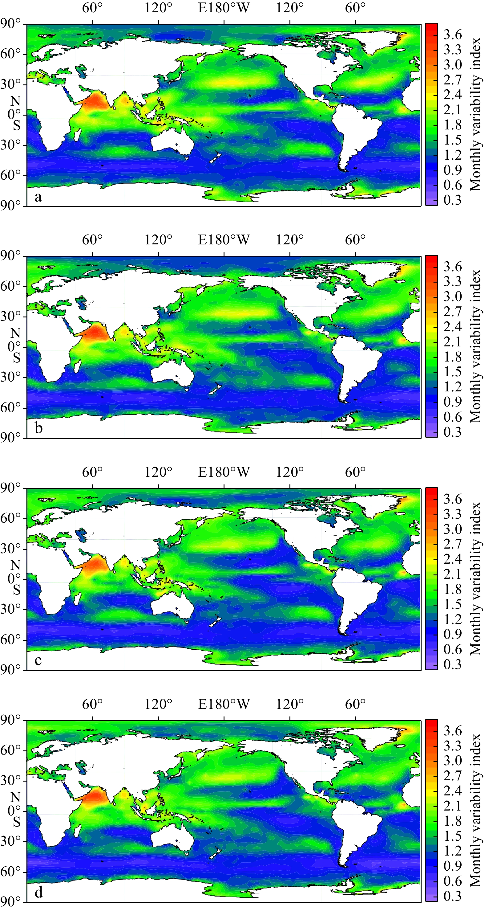
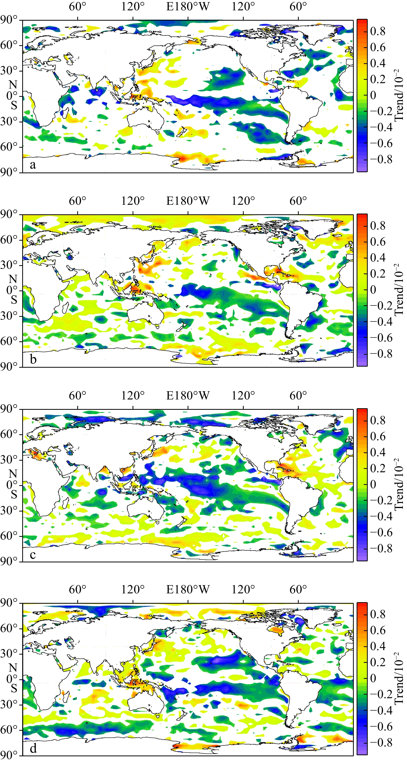
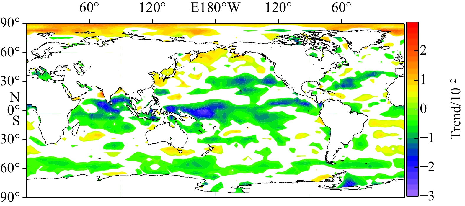
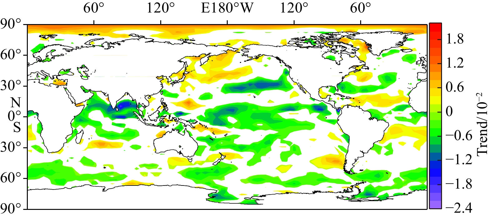
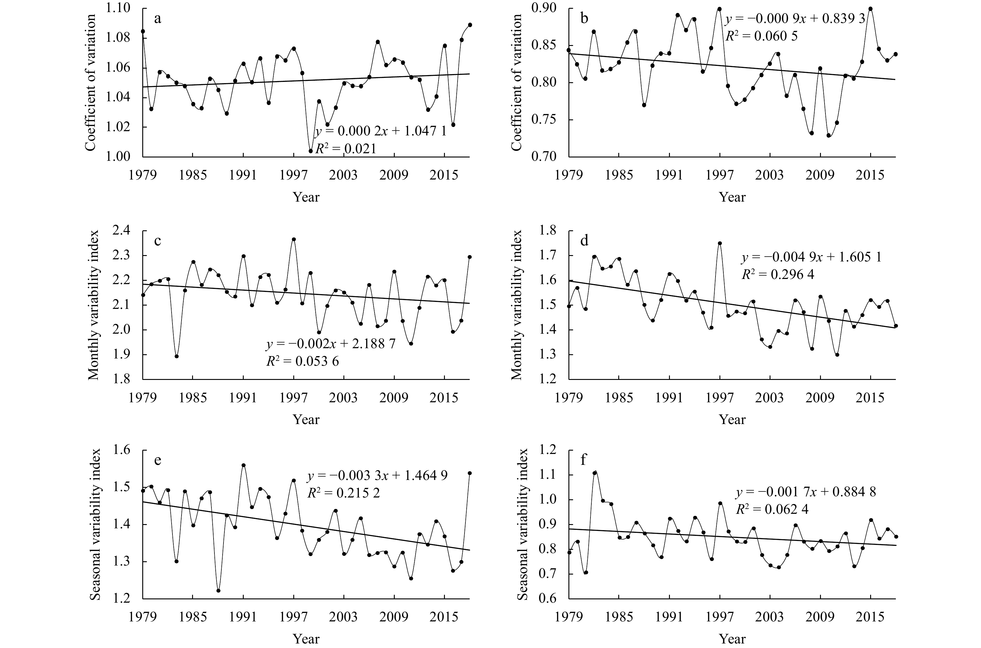
The recognition on the trend of wind energy stability is still extremely rare, although it is closely related to acquisition efficiency, grid connection, equipment lifetime, and costs of wind energy utilization. Using the 40-year (1979–2018) ERA-Interim data from the European Center for Medium-Range Weather Forecasts, this study presented the spatial-temporal distribution and climatic trend of the stability of global offshore wind energy as well as the abrupt phenomenon of wind energy stability in key regions over the past 40 years with the climatic analysis method and Mann-Kendall (M-K) test. The results show the following 5 points. (1) According to the coefficient of variation (Cv) of the wind power density, there are six permanent stable zones of global offshore wind energy: the southeast and northeast trade wind zones in the Indian, Pacific and Atlantic oceans, the Southern Hemisphere westerly, and a semi-permanent stable zone (North Indian Ocean). (2) There are six low-value zones for both seasonal variability index (Sv) and monthly variability index (Mv) globally, with a similar spatial distribution as that of the six permanent stable zones. Mv and Sv in the Arabian Sea are the highest in the world. (3) After Cv, Mv and Sv are comprehensively considered, the six permanent stable zones have an obvious advantage in the stability of wind energy over other sea areas, with Cv below 0.8, Mv within 1.0, and Sv within 0.7 all the year round. (4) The global stability of offshore wind energy shows a positive climatic trend for the past four decades. Cv, Mv and Sv have not changed significantly or decreased in most of the global ocean during 1979 to 2018. That is, wind energy is flat or more stable, while the monthly and seasonal variabilities tend to shrink/smooth, which is beneficial for wind energy utilization. (5) Cv in the low-latitude Pacific and Mv and Sv in both the North Indian Ocean and the low-latitude Pacific have an obvious abrupt phenomenon at the end of the 20th century.
The recognition on the trend of wind energy stability is still extremely rare, although it is closely related to acquisition efficiency, grid connection, equipment lifetime, and costs of wind energy utilization. Using the 40-year (1979–2018) ERA-Interim data from the European Center for Medium-Range Weather Forecasts, this study presented the spatial-temporal distribution and climatic trend of the stability of global offshore wind energy as well as the abrupt phenomenon of wind energy stability in key regions over the past 40 years with the climatic analysis method and Mann-Kendall (M-K) test. The results show the following 5 points. (1) According to the coefficient of variation (Cv) of the wind power density, there are six permanent stable zones of global offshore wind energy: the southeast and northeast trade wind zones in the Indian, Pacific and Atlantic oceans, the Southern Hemisphere westerly, and a semi-permanent stable zone (North Indian Ocean). (2) There are six low-value zones for both seasonal variability index (Sv) and monthly variability index (Mv) globally, with a similar spatial distribution as that of the six permanent stable zones. Mv and Sv in the Arabian Sea are the highest in the world. (3) After Cv, Mv and Sv are comprehensively considered, the six permanent stable zones have an obvious advantage in the stability of wind energy over other sea areas, with Cv below 0.8, Mv within 1.0, and Sv within 0.7 all the year round. (4) The global stability of offshore wind energy shows a positive climatic trend for the past four decades. Cv, Mv and Sv have not changed significantly or decreased in most of the global ocean during 1979 to 2018. That is, wind energy is flat or more stable, while the monthly and seasonal variabilities tend to shrink/smooth, which is beneficial for wind energy utilization. (5) Cv in the low-latitude Pacific and Mv and Sv in both the North Indian Ocean and the low-latitude Pacific have an obvious abrupt phenomenon at the end of the 20th century.